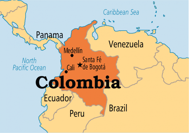
Colombia
Area 439,735 square mi (1,138,910 square km)
Population 48.93 million 2014
Capital Bogota
Highest Point 18,947 ft (5,775 m)
Lowest Point 0 m
GDP $377.7 billion 2014
Primary Natural Resources petroleum, natural gas, coal, iron ore.
COLOMBIA IS A country located in northwestern South America. Named for Christopher Columbus, it is the only South American country to have coastline on both the CARIBBEAN SEA and the PACIFIC OCEAN. The fifth-largest country in South America, Colombia is a nation of great geographic contrasts. From the 16th through 19th centuries, Colombia was a Spanish colony. In the early 1800s, the country gained its independence as part of Gran Colombia, consisting of modern-day Colombia, VENEZUELA, ECUADOR, and PANAMA. By 1830, Venezuela and Ecuador had separated from Colombia. In 1903, Panama also broke away from Colombia.
The Colombian ANDES consists of three ranges, or cordilleras. The Cordillera Occidental, Cordillera Central, and Cordillera Oriental branch off from each other just north of Colombia's border with Ecuador and run parallel to the north and northwest. While the Andes in Colombia are not as high as in some other South American countries, they have still traditionally posed a barrier to effective communication in the country. At the same time, they have provided Colombia with natural resources. The Cordillera Oriental is a major source of emeralds, allowing Colombia to become the world's leading producer of the precious stone. Colombia is the world's second leading producer of coffee; most is grown in the Andean highlands at altitudes of approximately 3,000 ft (914 m) to 6,000 ft (1,828 m).

The Andean highlands are the most densely populated region of Colombia. During the 19th and 20th centuries, between 60 and 70 percent of the country's population lived in the 15 percent of the territory located above 3,330 ft (1,006 m). Historically, the Andes have been the center of political and economic power in the country. Before the arrival of Europeans, Native American settlements concentrated in the Andes. Most notable were the Chibchas, a sedentary group who lived near modern-day Bogota. This region also attracted early Spanish colonists in the 1500s because of its mineral resources such as gold, a more pleasant climate than the tropical lowlands, and the potential labor force of the Native Americans.
In 1538, the Spanish founded the city of Bogota in the Cundinamarca basin because of the fertile soil and temperate climate. As the capital of Colombia, Bogota became and continues to be the political, cultural, and artistic center of Colombia. By the early 21st century, the city had nearly 7 million inhabitants. Other major cities in the highlands include Medellin and Cali. Located in the Antioquia region, Medellin prospered in the 19th century from the coffee industry. Residents invested much of the coffee profits in factories, making the city into Colombia's industrial, banking, and commercial center. Cali can be found in the Cauca Valley, a rich agricultural area. At the end of the 20th century, both Medellin and Cali served as centers for the illegal drug trade.
Two major river valleys play important roles in the Colombian highlands. The Cauca Valley is a narrow rift valley through which the Cauca River flows. The Magdalena River Valley is navigable for 600 mi (965 km) from the Caribbean coast. Until well into the 20th century, the Magdalena River was highland Colombia's main link with the outside world, as people and goods traveled up and down the river.
However, there were limitations to transportation along the river, as it possessed a difficult entry to its mouth and numerous rapids. Travelers sometimes needed as long as two months to travel along the tropical and mosquito-infested river. The Magdalena Valley has also been an important source of petroleum for Colombia.
Colombia possesses tropical lowlands along both the Caribbean and Pacific coasts. The Pacific coast is more sparsely populated. The natural conditions along the Pacific coast, such as the heat, heavy rainfall, and dense forests, have traditionally inhibited large settlements. The Pacific coast has a large Afro-Colombian population. Many of the region's inhabitants practice subsistence agriculture. Buenaventura is the main Pacific Port and is connected by rail to Cali.
Three main port cities dominate the Caribbean coast of Colombia. Founded in 1533, Cartagena was the principal Spanish colonial port in northern South America. By the 19th century, Baranquilla and Santa Marta were the country's main ports. The region around Santa Marta also became an important banana producing area. All three Caribbean ports have been important in connecting the outside world to the main population centers of Colombia in the Andes. Historically, communication took place via the Magdalena River.
The southeastern plains and jungles of Colombia comprise over half of the country's territory. However, the region contains just over 1 percent of the population. Located beyond the eastern Andes mountains, the oriente covers some 250,000 square mi (647,947 square km), representing about 60 percent of the country's total area. The region is roughly divided into two parts by the Guaviare River. The northern section of the region is known as the llanos, which is an area of grasslands used mainly for ranching. The llanos in turn are divided into two parts. The llanos arriba, or high plains, are closer to the Andes, receive more rainfall, and are used more for agriculture. The llanos abajo, or lower plains, receive much less rainfall and are used principally for grazing. The southern section of the oriente consists largely of tropical rainforest that reaches into the Amazon jungle. By the late 20th century, the southeastern section of the country had become more important thanks to the discovery of significant oil deposits.