El Nino and La Nina
Moody, tempestuous, violent: it's so easy to assign human qualities to El Nino and its companion, La Nina. This pair of atmospheric cycles broke into the news in the late 1990s when a remarkably strong El Nina wreaked global havoc. The pithy name fits well with headlines, and the concept – a strange, portentous warming of a faraway ocean that triggers bad weather – captured the public's fancy, especially in the US and Australia.
Millions of people around the world knew about El Nino by 1998, but few could have told you exactly what it was. Even the best scientists in the field have yet to detail all of the important factors that make El Nino and La Nina events blossom and wither. One thing that's now clear is that the brother-and-sister duo are part of an extended family of ocean/atmosphere cycles that shape weather over large chunks of the globe.
The basics
El Nino and La Nina are two sides of a coin. At the most basic level, an El Nirto happens when the surface water becomes warmer than average through the eastern tropical Pacific, a strip running west from the Ecuador coast. La Nirta is the opposite – the same waters are cooler than average.
These temperature changes aren't dramatic: only about 1-2°C/1.8-3.6°F for a weak Nino and 3-4°C/5.4-7.2°F for a quite strong one. La Nina departures are even less. What gives the cycles their immense power is their geographic scope. During the El Nino of 1997-98, the warmed waters covered an area the size of the US. Vast amounts of heat were pumped into the air above, and the result was a shift in weather patterns that cascaded across much of the globe. The exact chain of events that produces some El Nino impacts at surprising distances, such as in eastern Africa, isn't always well understood.
However, thanks to careful statistical analysis, we know the general kinds of weather that El Nino tends to produce, even if we don't know precisely how it does each trick.
El Nino and La Nina typically alternate, separated by neutral or near-normal periods that can last several years. On average, each Nino or Nina takes from one to three years to play out, although the lengths vary wildly. In the long run, the in-between periods occupy about as much time as El Ninos and La Ninas combined.
What makes it happen
To get to the bottom of El Nino, you have to go to its birthplace. The tropical Pacific is the world's broadest stretch of ocean. A boat trip from Ecuador to Papua New Guinea takes you more than a third of the way around the globe. Easterly trade winds blow almost incessantly across the length of these tropics. They push up so much water along their path that the sea level on the west side normally runs more than 50cm/ 20in higher than on the east side. The western end of this equatorial belt, close to Indonesia, is known as the western Pacific warm pool. It has some of the toastiest ocean water on the planet, averaging 30-32°C/86-90°F. Meanwhile, far to the east, much cooler seas prevaiL Offshore currents allow deep water to well up, supporting a rich marine life near the coasts of Ecuador and Peru.
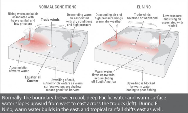
A similar set of contrasts normally play out in the atmosphere above. Near-constant showers and thunderstorms dump huge amounts of rain each year on the islands and oceans of the warm pool. But what goes up must come down, and the air that rises in rainstorms above the warm pool tends to flow back east at high levels and then subside over the eastern Pacific, suppressing rainfall there. Parts of the west coast of South America can go months or even years without seeing anything more than drizzle.
El Nino acts to reverse this flow of air and water. The stage is set with a gradual deepening of the warm pool waters so that they extend from the surface down as far as 200m/660ft. Every so often, a batch of especially strong and long-lived showers and thunderstorms pops up over the warm pool, coupled with a surge of westerly wind. As it presses against the ocean surface, this surge appears to help force a kink in the thermocline (the undersea boundary that separates warm surface water from cooler deep water). As the surge and the kink in the thermocline both push into the eastern Pacific, they help to suppress the usual cool upwelling. In a few weeks or months, warm surface water thus covers the entire tropical Pacific from shore to shore. Without the strong east-west contrast in sea-surface temperature, the trade winds weaken, sometimes even reversing direction.
Once this new air-and-water pattern is in place, it tends to sustain itself until El Nino runs out of steam. How this happens isn't totally clear, but one factor is the same thermocline kink that got things started. As the downward kink hits the east end of the Pacific, a slower-moving impulse rebounds to the west. It's eventually reflected off the shallow west end of the warm pool, and within a year or two, makes its way back across to the eastern Pacific, where it may help to shut down El Nino.
In some ways, the La Nina pattern is “even more normal than usual”. Instead of weakening, the prototypical air and water circulations strengthen. Trade winds blow harder, more warm water builds up near Indonesia, and the upwelling of cool water off Ecuador and Peru intensifies. The normally heavy rains in and near the warm pool, including eastern Australia, become even more intense. In the US, the standard wintertime clashes in air mass often step up, so that brutal cold spells may alternate with unusual warmth. The factors that make La Nina come and go are even more shrouded in mystery than El Nino's. We do know there isn't any tit-for-tat: the strength and length of a Nino have little bearing on the timing or intensity of the next Nina, and vice versa.
Calling the shots
In 1982, nobody knew that a catastrophic El Nino was forming until its effects were at hand In response, a set of instrument-studded buoys was installed across the tropical Pacific, and a new kind of weather and climate watching emerged These bobbing platforms sent back data every day on the water temperature at and below the surface. It was the first early-warning system for El Nino and La Nina. Now, with the buoys and with satellite monitoring of the ocean, we can spot the signs of a developing Nina or Nino months before its effects reach some places.
Computers make a big difference as well. Global models specially tuned to follow El Nino and La Nina can extrapolate the data from sea and sky and help provide a glimpse of whether the coming event is likely to be a doozy or a dud. Several of the models sensed in early 1997 that an El Nino was on its way, although none predicted its colossal strength until the Nino actually began unfolding that summer. Still, that was enough time to warn of the impacts that would likely follow by year's end. Governments around the world took heed Public awareness campaigns helped get roofs sealed, crops harvested and reservoirs drained before the impacts hit. Damages in California were far less than expected, most likely due to a combination of being prepared and a late start to the well-predicted torrential rains. (Comedians who mocked “El No-Show” in January had to eat their words in February.)
We haven't attained forecast nirvana yet. In parts of the developing world, warning systems aren't yet in place. Where the word does get out, El Nino fatigue can set in. The term became an all-purpose scapegoat across the US for what seemed like every weather event in 1997-98. Actually, El Nino or La Nina effects are seldom guaranteed. The odds may shift markedly toward wet or dry, warm or cold, but in any year the rest of the global atmosphere can counterbalance these likelihoods. For instance, rain and snow usually pound the US Pacific Northwest during La Nina, but conditions were unusually dry as a weak La Nina hung on during the winter of 2000-01. Toughest of all to predict are starting and stopping times. Much goes on in the water and air of the Pacific beyond the gaze of our observing system. And the most sophisticated computer models often disagree on timing, especially during the period from April to June, when the Pacific tends to be in transition between regimes. By September, though, it's often clear who will help dictate the worlds weather for the next few months: brother, sister or neither.