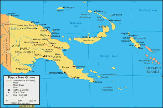
Papua New Guinea
Area 178,707 square mi (462,840 square km)
Population 7.464 million 2014
Capital Port Moresby
Highest Point 14,793 ft (4,509 m)
Lowest Point 0 m
GDP $15.41 billion 2013
Primary Natural Resources gold, silver, copper, natural gas, timber.
PAPUA NEW GUINEA IS an archipelago that includes the eastern half of the equatorial island of New Guinea, which lies between the Coral Sea and the South PACIFIC OCEAN, east of INDONESIA and north of AUSTRALIA. The country also encompasses much of the Bismarck Archipelago, including the islands of New Ireland and New Britain and the northernmost island of the SOLOMONS chain, Bougainville. The region has a monsoonal climate, with the wettest season lasting from December to March. Port Moresby, the capital of southern New Guinea, receives 39 in (1 m) of rainfall annually, while western New Britain regularly sees more than 20 ft (6 m) of rainfall per year.
The island of New Guinea was populated by migrants from Asia some 50,000 years ago. Evidence of complex human societies based on irrigated agriculture dates from 9000 B.C.E. Portuguese and Spanish explorers visited the area during the 16th century, but the island's size, large population, and difficult climate limited Europeans' advances. Dutch officials asserted their control over the western half of the island in the early 1800s, and it eventually became part of modern Indonesia.
GERMANY and the UNITED KINGDOM established claims over the eastern half of New Guinea in the 1880s, and Britain transferred its sector to AUSTRALIA in 1906, renaming it Papua. Germany lost its sector to Australia during World War I, and under an international mandate Australia governed the eastern half of the island. Much of it was seized by the Japanese, who also took control of the outlying islands, in World War II. After the war, New Guinea and many of the associated islands again were overseen by Australia, which guided them to full independence in 1975 as Papua New Guinea.
New Guinea is the world's second largest island, after GREENLAND. It is a geologically complex island dominated by rugged interior mountain ranges, high plateaus, and precipitous valleys, while its coastal areas feature powerful rivers, reedy deltas, and mangrove swamps. On the southwestern coast the country's longest river, the Fly, rises in the Victor Emmanuel mountains and flows through forested gorges before crossing plains and swamps. At is estuary it is 33 mi (53 km) wide. Also in the west is Lake Murray, the country's largest lake, which grows to five times its usual 400 square km (155 square mi) during the rainy season. In the northeast the great Sepik River travels 700 mi (1,126 km). With no natural delta, it deposits silt as far as 31 mi (50 km) out to sea.
The major islands of New Britain, New Ireland, and Bougainville, east of New Guinea, are part of an active volcanic formation known as the RING OF FIRE. The islands are surrounded by some of the largest coral reef complexes in the world. In 1994, 1997, and 2002, New Britain's principal city, Rabaul, was devastated by eruptions of the nearby volcano Tavurvur.
Papua New Guinea hosts 9,000 plant species, 700 species of birds, and some 200 species of mammals. Intensive logging of its rainforests and heavy metals pollution from mining operations, particularly on New Guinea and Bougainville, present difficult environmental challenges.