Hurricanes and tropical cyclones
The weather was probably quite tranquil on the Caribbean island of Barbados on the night of October 9, 1780: the calm before the storm. We know what it was like the next evening, thanks to Sir George Rodney. He and his fellow British colonials cowered in the government house, watching walls a metre thick crumble in a wind worse than any they'd ever seen. The next day, Rodney wrote: “Had I not been an eyewitness, nothing could have induced me to have believed it. More than six thousand persons perished, and all the inhabitants are entirely ruined.”
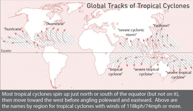
Such is the power of the atmosphere's trump card. Hurricanes – also called typhoons in the northwestern Pacific and cyclones in the Indian Ocean and South Pacific – have induced more abject misery more swiftly than any other weather feature on earth. The 1780 hurricane killed a total of 20,000 people on several islands. India and Bangladesh have fared even worse. Since 1700, more than a million people have perished in the face of tropical cyclones arriving from the north Indian Ocean.
The horror of hurricanes is intermingled with the romance of the tropics. One nightclub in New Orleans created a drink in honour of hurricanes, and hurricane parties were once a staple of coastal culture. Most people now know enough to base any such bashes well inland. In the US, hurricane damage continues to grow along with coastal development, but improved warnings and public awareness kept death tolls well under 100 per year from the 1970s into the start of the twenty-first century. That changed in a horrific way with 2005's Hurricane Katrina, whose vicious winds and floods teamed up with government ineptitude and an ill-prepared populace to kill more than 1700 residents of Louisiana and Mississippi.
Ironically, the worst disasters often happen as hurricanes dissipate, when slow-moving remnants can dump prodigious rains on mountainous areas. A dying Hurricane Mitch produced floods that killed some 10,000 in Honduras and Nicaragua in the autumn of 1998. In 1974 Typhoon Nina stalled just west of Shanghai and dropped more than 1.6m/63in of rain over three days. When two huge reservoirs failed, almost 100,000 Chinese died.
Ingredients of a hurricane
At heart, a hurricane is a heat engine that sucks energy from tropical oceans, often carting it northward or dispersing it along the way in the form of wind, rain and muggy air. Hurricanes always form over warm ocean waters. Since it's so much denser than air, water can hold a tremendous amount of heat Hurricanes feed on the warmth of the sea surface, as well as on the extra heat released into the air when a molecule of water vapour from the ocean condenses as rain. Experience shows that ocean temperatures usually need to be above 26°C/79°F for a hurricane to thrive. Since it takes a couple of months for ocean temperatures to peak after the summer solstice, hurricanes are most likely in late summer and early autumn. Late August and September bring the most Atlantic activity.
There's another requirement for hurricane growth: the upper winds mustn't be too strong, or the embryonic circulation will get pulled apart. The key incubation areas all lie between about 10° and 30° latitude north and south – in and near the tropics, but far enough from the equator so that Earth's turning can impart a cyclonic spin to the storm. Hurricanes can grow out of a variety of low-pressure centres across the tropical oceans, but the usual seeds are clusters of showers and thunderstorms called tropical disturbances or tropical waves. These pockets of disturbed weather slide like pearls along and near a necklace of converging easterly (west-flowing) trade winds that encircle the tropics. This band, called the intertropical convergence zone (ITCZ), shifts north and south to one side of the equator or the other every six months. Hundreds of waves form close to the ITCZ each year, but only some of them evolve into closed centres of low pressure. The closed low acts as a nucleus around which thunderstorms can further focus; it may be a chicken-and-egg question whether the thunderstorms induce the closed low or vice versa. Either way, the rising motion in the storms helps to draw in surrounding air, which rushes in to fill the vacuum that would otherwise result The stronger these winds are, the more warmth and moisture they can absorb from the ocean below. Predicting when this process will unfold successfully and when it will fail is still an uncertain art.
After a few hours or a few days, the sustained winds in a closed tropical low, or tropical depression, may reach 62kph/39mph. Once forecasters verify this trend – by sending a plane in to take measurements, or by watching cloud motion on satellite – they give the depression, now called a tropical storm or cyclonic storm, a name. Once winds reach 118kph/74mph, the storm is described as a hurricane, typhoon or tropical cyclone, depending on its location. There are about 80-90 such systems each year around the globe. This average is remarkably reliable in most years, even when some parts of the world are hyperactive and others stagnant.
Its possible that greenhouse-warmed oceans are adding extra punch to the hurricanes that do form. Several studies in 2005-06 lent credence to this idea, including a global survey that revealed nearly twice as many systems packing winds above 209kph/130mph than was the case in the 1970s. Critics pointed to errors inherent in hurricane analyses of past decades, but they also found themselves confronting the Atlantic's astounding 2005 season. Over the past century, hurricane production in the Atlantic has oscillated on an apparent multi-decadal cycle. It was active from the 1920s to the 1960s, then quiet until the mid-1990s, when activity again picked up. It's expected to begin waning again by the 2010s or 2020s, assuming that global change doesn't skew the cycle.
Charting its course
Before the days of aircraft and satellites, many tropical storms and hurricanes waltzed across the open ocean with only ships to keep tabs on them. One infamous surprise took place on September 21, 1938 on the US east coast Forecasters tracked a hurricane to the mid-Atlantic, off North Carolina, and then assumed it would veer offshore, as is typical at that latitude. Instead, it barrelled north into coastal New York at highway speeds. The hurricane flooded much of Providence, Rhode Island, and brought 299kph/186mph wind gusts to Blue Hill, Massachusetts, where forecasts a few hours earlier had called for a breezy but otherwise uneventful evening. Although more than 600 people died, the storm was virtually ignored outside the region The front page was stolen by British prime minister Neville Chamberlain's visit to Adolf Hitler and the Munich Pact finalized a few days later.
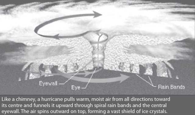
Aircraft began probing hurricanes and collecting weather data during World War II, and the practice became standard shortly afterwards. Radar in the 1940s, and satellites in the 1960s, gave humans their first look at the complete spectacle of a full-blown hurricane. Spiral bands of thunderstorms pinwheel around the centre. In the strongest storms, the central eye – a zone of clear skies and calm winds – appears as a picture-perfect circle.
With the help of current tools – including instrument packages that drop from airplanes, gathering and transmitting data as they parachute to sea – forecasters can now track hurricanes with ease. Computer guidance helps plot their course, with fair accuracy in most cases, up to five days in advance. When the upper-level winds that steer hurricanes are especially weak or poorly diagnosed, the track forecasts are the toughest. Fortunately, if a hurricane sits in one place for too long, it often churns up enough cool water from below to quell its strength. Strong upper-level winds can also weaken or destory a hurricane by tilting the circulation, blowing off the tops of its thunderstorms, or otherwise jeopardizing its symmetry and integrity.
Although forecasters can usually tell when a hurricane is doomed, it's much harder to predict when strengthening will occur. Even if all the ingredients seem to be on hand, not all storms will thrive as expected. The worst storms often go through a phase of rapid intensification that can transform them from minimal hurricanes to monsters in less than 24 hours. Hurricane Wilma shocked onlookers in 2005 as it vaulted from tropical-storm status to become the Atlantic's strongest hurricane on record (based on barometric pressure) in less than a day's time. Satellite-based radar can now scan some parts of the ocean for patches of warm water that are several times deeper than usual, extending as far down as 150m/500ft compared to the usual 30-45m/100-150ft. This extra fuel seems to be one element that hastens rapid strengthening.
Landfall and beyond
The classical motion of a Northern Hemisphere hurricane is westward through the tropics, with a gradual veering toward the north, and then a sharp “recurving” to the north and east at about 30°N, where the hurricane often encounters the westerly (east-flowing) winds that predominate at mid- latitudes. In the Southern Hemisphere, the tracks tend to be a mirror image; southwesterly, then southeasterly. The curve in these favoured paths tends to put the east coasts and the equator-facing sides of continents at the greatest risk of a hurricane strike. Tropical waters are at their warmest toward the western Pacific and western Atlantic, which adds to the east-coast risk, although the northwest Australian coast – which adjoins the warm Indian Ocean – is a particular hot spot. The northwest Pacific is the world capital of tropical cyclones, producing more than a third of the global total in a typical year. Some two dozen each year thread their way through otherwise tranquil islands; many go on to threaten Vietnam, China or Japan.
The air tends to sink on the periphery of a hurricane or typhoon to compensate for all the rising air within the showers and storms. This often produces strangely calm weather in the hours before a hurricane arrives. Winds and douds then increase, and periods of squally weather gradually intensify, punctuated by calmer spells. The eyewall – a ring of the most intense squalls – produces most of the wind damage. After Hurricane Andrew struck Florida in 1992, surveyors found evidence for mini-bursts of wind that caused severe damage across areas of less than a city block in no more than five seconds. A direct hurricane strike brings the eye across, producing a respite of a few minutes to an hour or more, inevitably followed by the other side of the eye wall, a trick of nature that has lured more than a few people to their deaths.
Wind is only one part of a hurricanes bag of destructive tricks. The sea surface bulges up a few inches in the low-pressure eye, but a far greater rise, or storm surge, is produced as the storms waters are funnelled into the coast. If the waters offshore are especially shallow, if the coastline is concave, or if a hill or mountain blocks the coast – or if any combination of the above occurs – the surge can be 6m/20ft or more. (Should a powerful hurricane ever approach New York City from the right direction – an unlikely but conceivable event – the city's harbour would help induce a storm surge that could inundate a good part of Manhattan Island.) As a hurricane moves inland and loses its oceanic fuel, friction helps weaken the winds, but it also helps set up a wind structure conducive to tornadoes. As many as sixty twisters have been reported in land falling hurricanes. Also, as happened with Mitch and Nina, heavy rains can trigger devastating floods.
Leaving the immediate coast is the best way to avoid the risk of hurricane. However, evacuation can be a delicate matter. If too many people leave from safer spots inland, they can clog highways and hinder the escape of those truly at risk along the immediate coast. Some US cities have emergency plans in place to house people in large structures such as stadiums when evacuation times are short, although Katrina showed how such a plan can quickly devolve into chaos. Well-built homes on high ground can be equipped to withstand many hurricanes with the help of clips that hold roofs in place and shutters that block debris from shattering windows. For more on hurricane precautions. Hurricane strength is assessed most often with the Saffir-Simpson intensity scale.