A shifting outer shell
Like any other crust, the Earths is a stiff outer layer that conceals what lies beneath. However, it is not a monolithic structure that sits unchanging and impervious below our feet. It is being transformed the whole time and on every timescale, from the day-to-day change associated with minor earthquakes on up to the shifting of continents and the opening and closing of oceans over millions of years.
The idea of the Earths crust has a solid foundation in evidence. Most of it comes from earthquakes. Although many earth scientists spend their careers trying to reduce the hazard that earthquakes pose to humanity, they also find them irresistibly interesting. Just as the true journalist loves a good murder for the front-page stories it will yield, so the Earth scientist appreciates a nice strong earthquake for the information it provides.
Even a modest earthquake registering 6 on the Richter scale releases as much energy inside the Earth as a one-megaton nuclear weapon. As the shock waves it produces spread through the Earths interior and are detected across the Earths surface, they provide information about the world beneath our feet. The approach is more or less a nature-powered version of the seismic technology used to hunt for structures which might contain oil and other resources inside the Earth. In addition, this talk of megatons is no coincidence. The same methods are used to detect underground nuclear explosions. Because armies tend to have bigger budgets than universities, one might argue that the Cold War was the best thing that ever happened to geophysics, the application of physics methods to the Earth.
These shock waves are able to tell us about the thickness of the Earths crust. It is apparent from observing the time they take to reach detecting devices – called seismometers – around the world that some of the earthquake energy is being reflected back from a major feature several tens of kilometres below the surface. In addition, other energy is running along this subsurface join and then getting refracted back to the surface.
This marker at the base of the crust was first identified by Andrija Mohorovicic, a Croatian scientist, in 1909. It is known as the Mohorovicic Discontinuity, or the Moho. There are two main reasons why the join between two layers inside the Earth will reflect seismic waves strongly. One is a big change in the density of the rock, and the other is a change in the velocity at which sound will travel through that rock. Below the Moho, it seems, the rocks allow sound to travel at about 8 kilometres a second, a kilometre or two per second faster than at the base of the crust. This change is very abrupt. Not only does it cause some waves to be reflected back up to the surface, but it also means that those waves which do pass through the crust into the mantle will get to distant detectors faster than those that have come through the crust. This allows the thickness of the crust to be calculated.
Continents afloat
The surprises come when the distance to the Moho is measured across the Earth. It turns out that the idea that the continents float on the mantle is pretty accurate. Below the oceans, the Moho is near to the surface and the crust is at its thinnest. Here it can be as thin as 5km, with 12km more typical. Below a continental landmass, it is typically perhaps 45km deep with a maximum depth of 75km below major new mountain ranges such as the Himalayas.
This means that it is best to think of the oceanic crust as a raft afloat on a lake, whereas the continental crust is more like a big ship, or even an iceberg, where there is as much below the sea as there is above. The deep invisible parts of a mountain range are called its roots. As we shall see, there are many places on the Earth where the passage of time has left these roots visible.
Of course, one object will only float on another if it is less dense but more solid than the thing it is floating in. This holds for continents as much as for shipping. Thus the continental crust has a density of about 2.7 grams per cubic centimetre, which is the typical density of granite, its dominant type of rock. The ocean floor is dominated by the denser rock basalt, about 2.9 grams per cc, while the top of the mantle averages about 3.4 grams per cc.
It has long been understood that the continents and oceans do not start and end where the blue bits on the map meet the land. It was known that sea level was far from being fixed in any case, so the coastline was best regarded as a temporary demarcation. Instead, depth sounding had shown that at the edge of (say) western Europe, the sea gets steadily deeper until it reaches a depth of perhaps 100-200m. This area is called the continental shelf and is economically important for everything from fishing to oil production. Generally the shelf might be a few tens of kilometres wide but some extend for hundreds of kilometres.
But the edge of the shelf is rarely in doubt. It is marked by the continental slope, a steep plunge – at Alpine angles of up to 45 degrees – down to the abyssal plain thousands of metres below. This is the ocean proper. During the 1960s, we began to appreciate the true difference between the make-up of the oceans and the continents, in a thought revolution as gripping as anything Einstein ever did for physics. This was the realization that oceans are new and constantly re-formed, while continents float about the Earth indefinitely.
Continents on the move
Even before the 1960s, there had been speculation for many years that the continents were not static. In particular, the apparent fit between the western coastline of Africa and the eastern shore of South America had tempted many observers to think they might once have sat together. Use the edge of the continental shelf as the marker instead of todays coastline and the fit is even more blatant.
The German geophysicist Alfred Wegener found many other lines of argument to corroborate the view that Africa and South America had once fitted together, especially from shared fossil species. He also looked back deeper into time and saw that there could once have been a single huge continent that he called Pangea.
However, Wegener died without seeing his theory gather a worthwhile evidence base. It was not until more than thirty years after his death on a scientific expedition to Greenland in 1930 that explanations began to emerge.
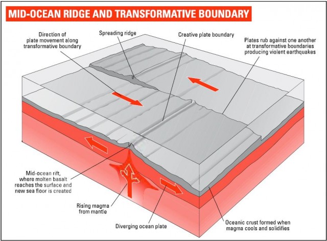
They started to appear with the development of instruments capable of measuring small variations in the magnetic properties of rocks. The centre of the action was the mid-Atlantic, which has long been known to be home to a ridge marked by active volcanoes and earthquake activity deep below the ocean. At some points, such as Iceland, it emerges above sea level. Measurements of the thickness of the crust along the ridge and other such ridges show that they are the places on Earth where the Moho is at its shallowest. It had been suggested that continents might drift because of the sea floor spreading from these ridges.
Now imagine sailing east or west from the ridge and measuring the magnetism of the rocks below. The scientists Fred Vine and Drummond Matthews found that the basalt of the ocean floor formed symmetrical bands of rock each side of the ridge whose magnetism alternated between pointing north and south. The reason (as we shall see in the next chapter) is that the Earths magnetism periodically reverses itself, so that the iron atoms in cooling lava sometimes settle in one direction as it solidifies and sometimes in the opposite one. As everyone said at the time, the stripes were like the magnetic domains in a tape recording, although nowadays nobody still alive remembers what that was.
It is now possible to corroborate the steady opening of the Atlantic at a few centimetres a year (in a much-used analog)', about as fast as your fingernails grow) by reflecting light from lasers in Europe and America off satellites. The time taken for the light to arrive gives the distance with an accuracy of less than a centimetre and allows the widening of the Atlantic to be seen in real time But the steady generation of new material shoving Europe and Africa on one side of the ocean steadily away from North and South America on the other cannot be the whole story. For one thing, the Earth is not getting detectably bigger, so if there is a machine making new crust, there must be another one removing it. Areas where crust is being drawn deep into the Earth are called subduction zones. These are where old oceanic crust descends deep into the Earth as it is pulled below thicker layers of continental crust.
For the full picture we must enter the world of plate tectonics – tectonics being the term tor the study of the Earths structure on a large scale. Don't call this process continental drift in the presence of geologists, or you will sound like an amateur.
Sliding plates
The large areas of the Earths crust that move about under the influence of plate tectonics are called plates. There are thirteen main ones on most reliable tectonic maps of the Earth. Tracing their boundaries is essentially about seismology (the study of earthquakes). At ridges where new material is being produced, small and relatively shallow earthquakes are common. They tend not to be massively damaging. At subduction zones, earthquakes are often rarer and more destructive, as in Turkey or the very destructive Indonesian earthquake of Boxing Day 2004. At places where the plates slide past each other, energy again has to be released in earthquake form. Here the models are California, or the 1755 earthquake that caused the destruction of Lisbon.
A few major plates make up most of the Earths surface, notably the Eurasian plate, which runs from the Mid-Atlantic Ridge to Japan, the African plate, which again starts at the Mid-Atlantic Ridge and covers all of Africa apart from its north-eastern extremities, and the Pacific, North American, South American, Indo-Australian and Antarctic plates, which you find more or less where the labels imply. Live in the centre of one of these plates and you are almost guaranteed not to die in a volcano or an earthquake. There are some seismically active faults, for example in Scotland, well away from plate boundaries, but they normally turn out to be fossil relics of old plate tectonic activity.
However, as the map shows, the picture is complicated by the existence of a number of much smaller plates, such as the Caribbean, Philippine and Arabian plates. One, the Juan da Fuca, deserves to be better known because its easterly edge, in California, is marked by the San Andreas Fault. This makes it perhaps the most closely observed geological feature on Earth. Its movement was responsible for the destruction of San Francisco in 1906, and it is constantly monitored for portents of what Californians term the Big One.
The existence of these small plates adds much to the supply of geological hazards. But it also tells us something of Earth history. As plates move around, new matter is either created at ridges or swallowed in subduction zones, characterized by deep ocean trenches. But it is impossible for this process to go on for hundreds of millions of years without some plates being broken up or partly consumed. Most of the small plates seem to have come into being in this way.
There are three main ways in which plates can meet: creative, destructive and transformative. Much as the Mid-Atlantic Ridge, pushing against the North and South American plates to the west and the African and Eurasian plates to the east, is the epitome of ocean floor spreading and therefore of creative plate tectonics, so the western coast of South America is the model for its destruction.
There, a deep ocean trench marking the edge of the Nazca plate is the spot where ocean crust is pushed below the South American plate, generating the earthquakes and live volcanoes of the Andes as it goes. The same process – this time where the Indo-Australian plates northward movement has brought it up against the Eurasian plate – is responsible for the formation of the Himalayas, the greatest mountain range of todays Earth.
At a transformative boundary, such as the San Andreas Fault, the plates rub against each other in ways that can cause tremendous upheaval but involve only marginal gains or losses of crust area.
Although plate tectonic maps of the Earth look definite, not every boundary has been explored in detail. But the idea of the Earths crust in motion turns out to have enormous explanatory power. The phenomenon of the “Ring of Fire”, the band of earthquake and volcano zones that surrounds the Pacific Ocean, is accounted tor. So is the tact that volcanoes associated with subduction zones produce lavas with a completely different composition from those responsible for sea-floor spreading. Indeed the Andes, produced as an effect of subduction, have given their name to Andesite, the lava that goes with it. Finally, the location of major mountain ranges is explained, as well as the forces behind their creation and destruction.