Maps and Cartography
Cartography is the field of geography concerned with making maps. A map is a paper representation of space showing point, line, or area data—that is, locations, connections, and regions. It typically displays a set of characteristics or features of the Earth's surface that are positioned on the map in much the same way that they occur on the surface. The map's […]
Development of Cartographic Understanding
The development of cartographic understanding has been approached from four different theoretical per spectives. The Nativist Approach The first one, the nativist, posits that cartographic understanding is innate. Three kinds of argument have been advanced for this perspective. The first one comes from a particular view concerning evolutionary development, according to which much of the structure of human mind is innately […]
Cartographic Animation
Animated maps, sometimes called movie maps or change maps, are primarily used to depict geographic change and processes. Cartographers have long been interested in the potential of map animation because representing complex geographic processes on static maps is a significant challenge. Put simply, animated maps are appealing because we live in an animated world. Humans also possess an eye–brain system […]
Cartography and Surveying in Iran in the Twentieth Century
In the twentieth century, cartography developed in Iran in three sectors – private cartographic and surveying companies, the army, and governmental civil institutions. The first private cartographic company, Sahab Geographic & Drafting Company, was founded in 1315 h sh/1936 by 'Abdolghasem Sahab (1265–1335 h sh/1886–1956) and led for most of the century by his son 'Abbas Sahab (1300–79 h […]
Cartographic Genres and Practices
In addition to the world and regional maps, portolan charts, and handbooks for sailing directions discussed in the previous section, a number of other cartographic formats were developed in Islamic societies. Early in the ninth century, or perhaps even in the eighth century, the question of how to determine from any given place the direction toward Mecca was raised. David A. King […]
Cartography in Islamic Societies
In Islamic societies, cartographic activities were part of courtly patronage and diplomatic exchange, educational literacy and scientific study, religious rituals and reminiscence, entertainment and the arts, and to some extent of war, seafaring, and administration. Many of the extant cartographic products are parts of manuscripts. Words, narratives, numbers, tables, and geometrical figures organize, structure, delineate, and interpret them. Books […]
Historical Cartography
A second form of geographical and historical investigation about the past involves maps compiled from data relating to an earlier situation. Interpreted generously as the writing of history with maps rather than words, the practice is older and the reasons for it more diverse than is generally described. In the thirteenth and fourteenth centuries, for example, maps of the world […]
The History of Cartography
The division of the history of cartography into 'old' and 'new' came about in the penultimate decade of the twentieth century. Examples of the use of the word 'cartography' in Germany as early as the second decade of the nineteenth-century have been found, but the idea of a formal history of cartography for the study of old, that is, nonmodern, maps […]
Approaches to the History of Cartography
For geographers, the relationsip between maps and history has taken several forms. The terms used to describe each form are not synonymous; the 'history of cartography' is not the same thing as 'historical cartography' or the 'history of mapping', although in practice the boundaries between the categories of activities noted below are neither precise nor impermeable. Many studies conducted under […]
Cartography, History of
The ubiquity of maps today is beyond dispute. They are treasured as decoration in private and public places, and enjoyed in exhibitions. Whether in manuscript or print, or on television, maps are the workhorses of weather forecasters, reporters, political and cultural commentators, cartoonists, textbook writers, scientific researchers, administrators, and planners alike. As printed road atlases (or, increasingly, electronic satellite navigation systems), they […]
Invisible Data Mappers: Artists Who Use Cartographic Metaphors to Visualize Informational Territories Such as the Stock Market, the Internet, or the Human Genome
The twentieth century witnessed many technological and social changes as people developed new ways of sensing the world, communicating with each other, killing each other, and moving through space. These changes helped spawn what might be called 'informational territories' – virtual, invisible, infinitely small or large, multidimen sional, time based, and even cultural and political 'spaces'. The Internet, the stock market, the […]
Art and Cartography
In the last century, and especially in the last 30 years, artists have made maps, subverted maps, performed itineraries, imagined territories, contested borders, charted the invisible, and hacked physical, virtual, and hybrid spaces in the name of cartography. Numerous names have been suggested for various strains of this intersection: 'psychogeography', 'locative media', 'experimental geography', 'site specific art', 'new genre […]
cartography
A TERM DERIVED from the word for chart (charte) or drawing, cartography is traditionally defined as the art and science of making maps. But over the years, a great deal of theoretical and practical research has been done in all aspects of the subject, including work on map projections, map designs, map visualization, cartograms, terrain models, and the incorporation of new computer-based […]
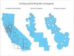
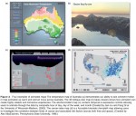
cartogram
ONE OF THE LIMITATIONS of the traditional paper map is that real world areas with large populations are usually small in physical size and therefore represented as small area units on a map. As such, traditional paper maps have tended to mask geographic patterns in small area units that are of importance and interest on the map. The […]