cartography
A TERM DERIVED from the word for chart (charte) or drawing, cartography is traditionally defined as the art and science of making maps. But over the years, a great deal of theoretical and practical research has been done in all aspects of the subject, including work on map projections, map designs, map visualization, cartograms, terrain models, and the incorporation of new computer-based technologies such as geographic information system (GIS) data and remote sensing images into the map-making process. These research and technological developments have increased the utility of cartography for services such as geographic data display, storage and analysis, communication, planning, and decision making. At present, the International artographic
Association defines cartography as the art, science, and technology of making maps, together with their study as scientific documents and works of art.
An understanding of general cartography trends can proceed along two interconnected pathways. In the first pathway, the emphasis is usually on the finished map product together with valuations about the map functionalities, techniques used, symbology, and aesthetics. In the second pathway, the emphasis is on the data-surveying and compilation aspects of the mapping process. Historical maps and their presentation as graphical objects such as atlases and sheet maps are characteristic of the first “map product” pathway. Later, the integration of information and communication technology (ICT) into mapping and the inevitable data generation and processing consequences have come to define the “data compilation” pathway. In this second pathway, the impact of the mapping process on the map output is the major focus of study.
THE STUDY OF MAPS
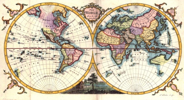
The modern study of maps always originates with a description of how maps work. All maps are about spaces and places that are represented by shape, area, distance, direction, and location in a graphical medium. The surface of the Earth is not a flat plane, so a modification is required to transform the positions of places on the curved earth to the flat sheet of the map so that distortions in shape, area, distance, direction, and location are minimized. This process is called map projection, and the transformation is governed by rigorous mathematical rules.
The projection process takes the lines of latitude and longitude of the round earth and arranges them on a flat plane as a uniform grid. These grids, together with a scale that links the relative linear proportions of the round earth and its representation on the flat plane, allow the map space to be structured so that map properties can be determined to a high level of accuracy. Some examples of projections include the Mercator and Robinson projections.
The scale of the map determines the level of detail that can be shown. Maps of a large scale show more detail with greater accuracy. As the map scale becomes progressively smaller, larger swaths of geographic areas are shown and so features on the map must be generalized to avoid congestion. The generalization procedure involves stages of simplification, selection, enlargement, displacement, and merging. Simplification involves the progressive collapsing of map features from area to line to point representation as scale decreases. As an example, a lake may be represented as an area at one scale but as a point at a smaller scale. Selection attempts to retain features that are important given the goals and uses of the map. However, some of these important features might not be clearly visible at the desired scale, and so enlargement artificially distorts their dimensions to enhance visibility. Displacement shifts overlapping features so that they become separate elements and more clearly identifiable. Merging aggregates multiple features into simpler ones to correct map overload that can arise from too much detail.
The mapping process also includes the symbolization of the real world using a standardized graphical language. The symbols used have dimensions—point, lines, areas, volumes, and duration—and can be distributed in a discrete, continuous, or sequential manner to communicate feature patterns. Lettering and text labels also form an important part of the feature encoding process. Information about each feature, such as type of road or population, is encoded using variations in nine graphic variables. The graphic variables are size, shape, orientation, color value, color intensity, level of grayness, texture, focus, and arrangement. These graphic variables, together with strict rules for their use, allow the cartographer to encode and distinguish the many features on the spherical real world unto the flat map.
Cartography demands a diverse mixture of scientific and artistic skills to produce effective maps. Cartographers are visually oriented individuals with a talent for communicating with drawings, symbols, and graphics. They attempt to balance rigorous scientific methods with artistic elegance to communicate an accurate, appealing, and easily understandable message through the map medium. However, simply combining all the map elements does not guarantee an effective and aesthetically pleasing map. The challenge then is to understand what constitutes a good map.
A list of qualities that could characterize excellence in statistical graphic designs was proposed by Edward Tufte in 1983. This list was viewed by cartographers as important because if applied to maps it would emphasize the importance of the perceptual qualities of the map design rather than the individual map components. Key principles to emerge were that a visual organization of images and a hierarchy should guide the map design between different visual levels. These design principles, together with the artistic abilities of the cartographer, can lead to a balanced, pleasing map.
Computer technology has also influenced cartography in many ways. The use of computer software to automate the map design process has probably been the greatest influence. However, with these improvements in efficiency come new challenges. Selecting the best software for the mapping task and using the software effectively has become one of the main challenges. The proliferation of drawing and illustration software packages has only served to intensify the challenge. Computer literacy is also a cause for concern because many software packages require some knowledge of computer systems operation. Other challenges include paper to digital map conversion accuracies, complexity of data to be presented, output medium, and the future usability of digital data derived from the conversion process.
GIS AND RS
Geographic information systems (GIS) and remote sensing (RS) have established a beneficial synergy with cartography. Although these technologies have been around since the 1960s, it is only in the last 10 years or so that a stronger link was established with cartography. A GIS is a collection of computer hardware, software, and trained personnel designed to capture, store, manage, manipulate, and communicate data that is spatially referenced. Remote sensing is the gathering of information related to the Earth's surface and does not involve contact with the object under study. RS techniques include aerial photography, radar, and satellite imagery.
Usually remote sensing is accompanied by some “ground truthing,” where the researcher visits multiple areas to make sure that the images being received are interpreted correctly. These new digital tools have aided the production of maps. While some maps are still hand-drawn, many more are produced through the analysis of GIS data sets and overlay operations, and digital image processing and classification. Current GIS and RS software now support mapping modules that allow the flexibility and functionality to produce good map products.
Well-known GIS software includes ArcView, Arc- GIS, MapInfo, and ArcInfo; ER-Mapper, IDRISI, and ERDAS Imagine are equivalent digital image processing software. An important concept that permeates GIS and RS software is that of raster and vector data processing capabilities. Raster data store the real world as grid cells where each cell represents some attribute on the Earth's surface. Vector data store the real world as a collection of points, lines and areas. While it is relatively easy to convert between the raster and vector data forms, the cartographic approach has been to select one data form most appropriate for the project goals and to use it consistently throughout the project.
However, despite their advanced functionalities, GIS and RS software still do not yet allow cartographers the flexibility to go beyond the creation of an electronic version of the paper map. This is maybe due to software business strategies that minimize GIS and RS software complexity to maintain broad-based enduser adoption. Ultimately the customization of the final map product is completed by illustration and drawing software packages such as Adobe Illustrator and Macromedia FreeHand. The integration of GIS and RS has provided new ways to visualize data in search for new map patterns and trends that can support analysis and decisions. The role of cartography in the synergy is to guide the development of “good mapping” products for multiple uses and users.
The rapid evolution of the internet and its impact on cartography have been another area of excitement and new opportunities for cartographers. The internet and world wide web (web) are a distributed collection of multimedia information networked together. Access to this information resource is through a browser such as Internet Explorer and Netscape. Of importance to cartographers is the use of the web to enhance, access, and deliver map products. The first wave of enhancements in multimedia cartography improved the static digital map by integrating features such as video, audio clips, and animations to present information in a more integrated manner.
The current wave of enhancements is termed web- GIS, internet-GIS, or web-based mapping and addresses issues such as data democratization and end-user analysis capabilities. The mapping products delivered to end users can range from a simple static digital map to a completely immersive and interactive mapping environment in which to explore and navigate the digital map space. Despite the rapid progress in multimedia cartography and web-GIS, there are still a number of challenges to overcome with the use of the Web in cartography. These challenges are directly related to the data used and incorporate research issues such as standards, interoperability, quality, confidentiality, copyright, and individual privacy.
Today, traditional cartographic principles have been continuously adapted to a variety of user needs and technological changes but still form the core of many digital mapping projects. The Internet holds the key to the continual evolution of cartography. This is so because the Internet integrates both cartographers and noncartographers to communicate, use, and analyze maps, all of which raises awareness of and competence in digital mapping products. The proliferation of digital data on the Internet has also made it relatively easy to produce digital maps.
Students can best prepare for the future of cartography by keeping up to date with new technologies such as GIS, RS, and spatial data analysis. A lack of relevant training in these areas has been cited as the primary source for poor mapping products, especially since software products are now readily making mapping functionalities available but with little or no guidelines for effective map design. Another aspect of relevance to good map design is color choice and selection. While color theory is well developed for paper maps, there is not much systematic knowledge about color choice and use in an electronic medium.