Types of Atlases
Atlases, whether in conventional or electronic form, portray (1) a clearly defined region geographically or (2) a specific topic or theme.
General-Reference Atlases
Atlases can depict a specific area or cover the entire Earth. The latter are often referred to as general refer ence atlases and contain mainly small scale physical maps to emphasize locations of places and their spatial relationships. General reference atlases typically also contain additional noncartographic information such as tabular data, (air) photos, satellite images, explanatory texts, and, most importantly, indexes of place names and geographic objects linked to coordinates (e.g., latitude and longitude or an internal locational grid consisting of numbers and letters along the sides of the atlas maps). General reference atlases, which portray a specific area rather than the entire Earth, typically comprise large to medium scale topographic maps, depending on the size of the region shown, and are often referred to as topo graphic atlases. Two examples of general reference at lases are the Times Atlas of the World and the Atlas of the World by Oxford University Press.
Regional and National Atlases
Some atlases concentrate on a specific region, for ex ample, a specific country, a province or state, or any other geographically or culturally defined region and portray it in a more comprehensive manner. Atlases, portraying a region, province, or state rather than a specific country, are referred to as regional atlases. Other than general reference atlases, regional atlases are not limited to dis playing the physical environment and topography but document a region more broadly. In doing so topics can vary and cover all subject areas of physical and human geography. A region or area can vary from a relatively small area such as a city to a group of states or even a continent. Most regional atlases are also considered to be thematic atlases as they focus on one main theme or subject area. Examples of regional atlases among many others are the Atlas of Oregon and the Atlante Socio economico della Regione Insubrica (Socio economic Atlas of the Insubrica Region), produced in the Swiss–Italian cooperation.
Special types of regional atlases are national atlases. As complex regional atlases referring to a national state they display current thematic information on the physical and human environment, usually in a series of medium to small scale maps. At the same time, they depict the status of geographic visualization and geographic information technology employed in their production and can therefore be seen as a country's official carto graphic business card. Typically, government agencies or research institutions edit and publish national atlases, which are predominately geared toward research, and are of a problem oriented nature. National atlases can also be seen as comprehensive collections of current geographic knowledge of the countries they document. Depending on the design and structure, many national atlases also address the general public to raise awareness of a country's specific characteristics. Additionally, national atlases play more than one role: on the one hand, they provide a comprehensive summary of a country's physical and human geography by displaying current results of geographic and cartographic research and achievements; on the other hand, they are a symbol of a country's unity and political independence. Hence, national atlases have played an important role in nation building (e.g., the National Atlas of Finland was pub lished in 1899 before Finland became an independent state in 1917).
Due to the complexity and the large number of pos sible themes and related workload, national atlases are often published in a number of separate volumes, each portraying one single theme (e.g., demography, physical environment, and climate). Other national atlases are published as a series of single map sheets, which are successively assembled in a map case.
Thematic Atlases
Contrasting to general reference or topographic atlases, thematic atlases depict one selected geographic theme (or a small number of related topics). The number of themes is almost unlimited. Themes can range from geology, climatology, demography, land use, planning, etc.
A special type of thematic atlas is a school atlas. It is based on didactics, following the principle from familiar to unknown, from near to far away, rather than the re verse, more common order of maps and topics found in general reference atlases. Traditionally, school atlases focused on small scale physical maps but are increasingly complemented by thematic maps on various topics. School atlases usually are published according to official school curricula.
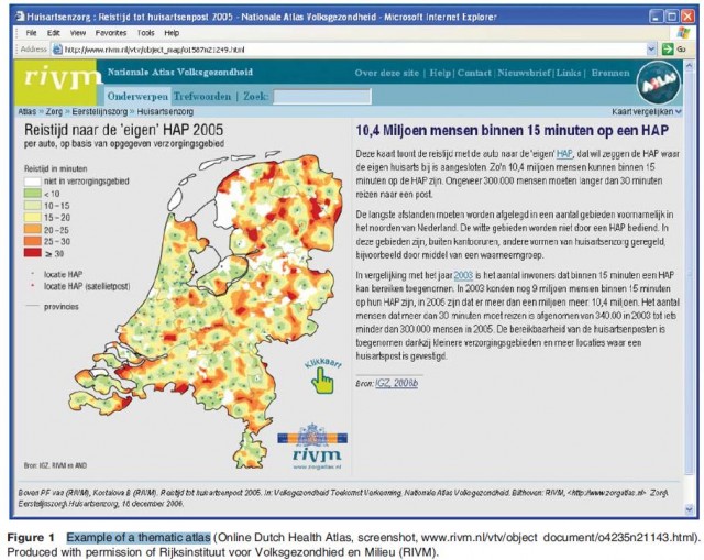
Thematic atlases can be produced and distributed as conventional paper version or as electronic version. Selected examples of thematic atlases are the Historical Atlas of Canada, the German Weltseuchenatlas (Atlas of Epidemic Disease), and the digital Dutch Health Atlas (Figure 1).