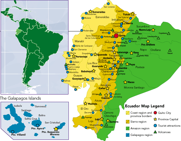
Ecuador
Area 109,483 square mi (283,560 square km)
Population 15.98 million 2014
Capital Quito
Highest Point 20,561 ft (6,267 m)
Lowest Point 0 m
GDP $100.5 billion 2014
Primary Natural Resources petroleum, fish, timber, hydropower.
ECUADOR IS A SMALL country located on the west coast of South America. The equator crosses the country, thus giving Ecuador its name. The country is bordered by the PACIFIC OCEAN to the west, COLOMBIA to the north, and PERU to the east and south. Territorial disputes with both Colombia and Peru have reduced Ecuador's territory.
The Pacific coastal zone, mainly an ALLUVIAL PLAIN, consists of 60,000 square mi (155,399 square km) of land between the ANDES MOUNTAINS and the Pacific Ocean. These lowlands form the widest coastal plain in South America, reaching widths of 125 mi (201 km). While there are some hills, the region is largely flat. The northern coastal region is largely RAINFOREST, while the south consists of tropical woodlands. The region contains a number of important river valleys. Some of the rivers are navigable for long distances, with the basins of the Guayas, Esmeraldas, and Santiago rivers creating an extensive inland waterway network.

The key area of the coastal zone is the Guayas Lowland, where much agricultural production takes place. This agricultural production is geared to the export economy. The main crops include cacoa, coffee, bananas, and rice. Others regions of the coastal lowlands are used for fishing and cattle raising. Ecuador has also exploited oil reserves in the coastal region. Thanks to the presence of such resources, the coast has long dominated the economy of Ecuador.
The main city of the lowlands is Guayaquil, located on the western bank of the Guayas River. Guayaquil is an important port and commercial center, serving as an outlet for the region's products. It is also the country's largest city.
Known as the Sierra, the Andean highlands of Ecuador make up about one-fourth of the country's territory. These highlands are made up of two cordilleras, or ranges. The Ecuadorian Andes are narrow but high, averaging an altitude of over 10,000 ft (3,048 m). The ranges consist of high, snow-topped, volcanic peaks. The highest peaks are Chimborazo, which reaches an altitude of just over 20,000 ft (6,096 m), and Cotopaxi, which is just under 20,000 ft. In addition to dozens of volcanoes, the region is also subject to strong earthquakes. For example, an earthquake in 1797 completely destroyed the city of Riobamba, forcing survivors to rebuild at a new location.
A 300-mi- (483-km-) long intermontane plateau is located between the eastern and western ranges. Transverse mountains divide the plateau into 10 basins at elevations between 7,000 ft (2,133 m) and 10,000 ft (3,048 m). The basins fall into one of four climatic zones. The area above 10,065 ft (3,246 m) is known as paramo, which is barren and windswept. The paramo is generally used for pastureland and to grow potatoes, a crop native to South America. At elevations of 8,052 ft (2,454) to 10,065 ft (3,246 m) is the altiplano, used for both pasture and growing grains. Temperate valleys can be found at altitudes from 6,039 ft (1,840 m) to 8,052 ft (2,454 m). Temperate crops are grown in these valleys. Finally, from 3,018 ft (920 m) to 6,039 ft (1,840 m) are tropical valleys, where in addition to potatoes and grains, Ecuadorians grow cotton, sugarcane, and fruits.
This plateau forms the densely populated heart of Ecuador and has historically dominated the country. Pre-Hispanic cultures centered here and the Spanish preferred the Andean plateau over the coastal zone. Quito, the capital city, is located in the plateau at 9,350 ft (2,850 m). The region contains a large percentage of Native Americans and mestizos (mixed race).
The hot and humid eastern lowlands of Ecuador are known as the Oriente. This region comprises about half of the country's territory. The Oriente has often been at the center of territorial disputes, and Ecuador has lost large sections of this region to its neighbors. It covers the area stretching from the eastern foothills of the Andes to the AMAZON RIVER basin. Much of the Oriente is a FLOODPLAIN covered with tropical woodlands and rain forests. There are navigable rivers in the region. However, they generally flow away from the settled areas, making them of limited use.
Historically, the Oriente has been isolated, underdeveloped, and sparsely populated by humans. Before the 1960s, both settlement and investment in the region were very limited. Ecuadorian authorities paid attention to the area only when border disputes arose. The fact that most of the population consisted of Native Americans further contributed to government neglect.
Heavy rainfall has made human settlement unattractive, as dry land shrinks during the rainy season, wild game is scarce, and agriculture is difficult. In the northern Oriente, annual rainfall can reach 167 in (424 cm). After the 1960s, the government became more interested in the Oriente due to the discovery of significant oil deposits. High world oil prices in the 1970s led to increased investment in the region.
Ecuador is also home to the famous Galapagos Islands, where Charles Darwin conducted experiments there in 1836 leading to his evolutionary theories. Known as the Archipelago de Colon, the Galapagos Islands consist of five larger islands and nine smaller ones.
The islands are located in the Pacific Ocean about 600 mi (965 km) west of the mainland. Their total area is just under 3,000 square mi (7,770 square km) and there are few inhabitants, most notably because potable water is scarce.