Equatorial Guinea
Area 10,831 square mi (28,051 square km)
Population 778,100 (2014)
Capital Malabo
Highest Point 9,870 ft (3,008 m)
Lowest Point 0 m
GDP $14.31 billion (2014)
Primary Natural Resources petroleum, wood uranium, gold, manganese.
EQUATORIAL GUINEA is located in west-central Africa just north of the equator. It is made up of Rio Muni on the African mainland and the islands of Bioko, Annobon, Corisco, Elobey Grande, and Elobey Chico. Rio Muni is bordered by CAMEROON to the north and by GABON to the east and south. The Campo River forms part of the northern boundary with Cameroon, and the Rio Muni River forms part of the southern boundary with Gabon. These two rivers, along with the Mbini River, located in the center of Rio Muni, are the three largest rivers in the country.
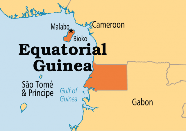
Rio Muni contains 93 percent of Equatorial Guinea's total landmass, and 80 percent of the population lives here. The major urban areas in Equatorial Guinea include Malabo and Luba on Bioko Island and Bata, Mbini, Ebebiyin, Mongomo, and Evinayong on the mainland of Rio Muni. Both Bioko and Annobon islands are volcanic. Equatorial Guinea has a tropical climate that is hot and humid year-round. Along the coastal plain, the city of Bata is cooler and drier than the rest of the country. Rio Muni is mainly hilly terrain averaging about 2,000 ft (610 m) in elevation with some 4,000-ft (1,220-m) peaks.
Bioko Island, which was called Fernando Po until the 1970s, lies about 25 mi (40 km) from Cameroon and is the largest island in the Gulf of Guinea, covering 780 square mi (2,017 square km). It was discovered in 1471 by Portuguese explorer Fernando Poo, who was seeking a route to INDIA. PORTUGAL controlled the island until 1778, when it ceded this, surrounding islets, and commercial rights to the mainland between NIGER and the Ogoue River to SPAIN in the Treaty of Pardo in exchange for territory in South America (mainly territories in BRAZIL). Bioko is made up of three extinct volcanoes, the largest of which, Pico Basile, reaches up 9,870 ft (3,008 m). The coastline is 120 mi (195 km) long, very steep to the south from the volcanoes rising up, and much lower in the northwest, with good harbors at both Malabo and Luba.
Also along the northwestern coast between Malabo and Luba are several scenic beaches. Indigenous to Bioko Island are the Bubi people constituting 15 percent of the population. The Bubi are descendants of slaves liberated from western Africa by the British during the 19th century.
Originally, it is believed that the first inhabitants of Equatorial Guinea were Pygmies who still live in isolated areas of northern Rio Muni. The majority of the people of Equatorial Guinea are of Bantu origin, most of these being from the Fang tribe, which makes up 80 percent of the total population of Equatorial Guinea. Spain granted Equatorial Guinea independence on October 12, 1968. After gaining independence, they suffered for 11 years under a repressive dictatorship that suppressed the local economy. Equatorial Guinea's economy was mainly based on developing the rich volcanic soil for agricultural use. They grow cacoa, coffee, plantains, cassavas, sweet potatoes, and palm oil. They are slowly developing their fishing industry with the help of Spain, NIGERIA, and MOROCCO. Oil and gas discovered offshore is now the main export and will continue to drive the economy for years to come.