How Do Variations in Temperature and Pressure Cause Local Atmospheric Circulation?
PRESSURE GRADIENTS INDUCE FLOW at all scales, including local and regional ones, arising from unequal heating by insolation and latent heat, by differing thermal responses of land versus sea, and even from the construction of large metropolitan areas. Such circulations contribute to the climate of a place, particularly in the absence of, or interaction with, more powerful circulations.
What Causes Breezes along Coasts to Reverse Direction Between Day and Night?
People who live along coasts know that gentle winds sometimes blow in from the sea and at other times blow toward the sea. The gentle winds are called a sea breeze if it blows from sea in toward the land and a land breeze if it blows from the land out to sea. Such breezes are mostly due to differences in the way that land and sea warm up during the day and cool down at night.
The Sea Breeze (Daytime)
1. During daytime hours, land heats up significantly, particularly in summer. Land, which has a lower specific heat capacity than water, heats up more overall and more rapidly than water does. The hot air over the land surface rises, inducing a local low-pressure area over the land.
2. At the same time, air over the water body is cooled by the relatively cool water temperatures and by cooling associated with evaporation. The relatively cool air over the water sinks, inducing a local high-pressure area over the water.
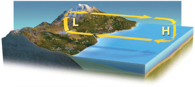
3. The difference between the low pressure over land and the high pressure over the water represents a pressure gradient. The associated pressure-gradient force pushes air near the surface, from higher pressure to lower pressure. This flow is an onshore breeze or sea breeze that feels cool to people on the beach.
4. Air aloft moves in the opposite direction, from land to sea. This is a response to an upper-level pressure gradient caused by the “extra” air rising over land and less upper-level air over the sea, due to air sinking.
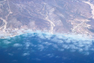
5. In this photograph, heating of the hot, desert land causes air over the land to rise, drawing in moist air from the adjacent water. Rising of the moist air along the coast forms thin, scattered clouds, but can draw in much thicker masses of clouds, forming coastal fog and overcast skies.
The Land Breeze (Nighttime)
1. At night, land cools significantly, particularly if there isn't much cloud cover. The relatively cool air over the land surface sinks, inducing a surface high-pressure area. Sometime in the evening hours, the surface low over the land weakens and becomes a high.
2. The water body doesn't cool as much at night, partly because of water's higher specific heat capacity and because of mixing. So air over the water stays relatively warm compared to the air over the land. Therefore, this air rises, generating relatively low pressure over the water body.
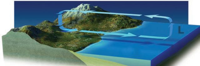
3. The difference between the high pressure over land and the low pressure over the water is a pressure gradient. The pressure-gradient force pushes near-surface air from higher to lower pressure, from the land to the water as an offshore breeze or land breeze.
4. Aloft, the pressure-gradient force causes the air that rose over the low to return to land to replace the air that sank to create the surface high.
5. The strength of sea and land breezes is proportional to the temperature gradient. The land breeze circulation strengthens through the night, begins to weaken at sunrise, stops sometime in the morning, and then reverses to a sea breeze, when it strengthens until peaking in the afternoon.
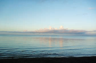
6. In this photograph, an early morning offshore flow, from the land to the sea, pushes moist air offshore, moving clouds out to sea and causing clear conditions along the shoreline.
How Does Topography Cause Pressure Gradients?
On land, topography can cause pressure gradients and winds that blow in different directions during the day versus at night. These are primarily related to differences in the way land and the atmosphere heat up and cool down, and to temperature differences as a function of elevation.
1. The Sun heats the surface more efficiently than it heats the atmosphere. During the day, the land heats up and in turn heats the adjacent air. Such heated air from lower elevations is especially warm and rises, causing upslope winds, known as a valley breeze, or anabatic wind. Air that is farther from the surface, aloft in the center of the figure shown here, is less heated and so sinks to replace the rising air. Upslope winds are most obvious when winds from other types of circulation, like storms, are weak.
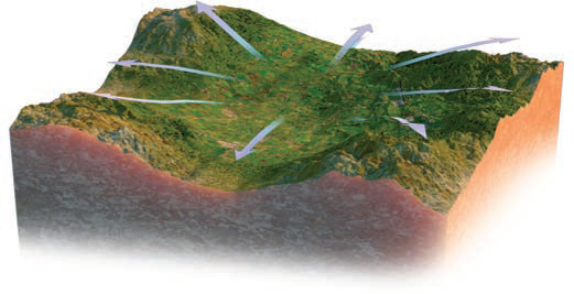
2. At night, the situation is reversed. With no insolation to warm the surface, the surface will cool more rapidly than the air above it, as it emits longwave radiation to the atmosphere. Thus, the land and adjacent air at higher elevations cools significantly, and the resulting relatively cool surface air will move downslope, producing a mountain breeze, or katabatic wind. The cool air displaces warmer air in the valley upward, where it can flow to replenish the air lost at higher elevations. The end result is that valley bottoms can be substantially colder at night than areas at a slightly higher elevation.
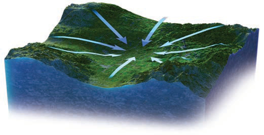
3. Pollution in rugged terrain is mostly produced in the valleys where people are more likely to live, so the daytime valley breezes push polluted air upslope. But if the pollution is too intense or the slopes are too high and steep to push the air over the ridges and peaks before nightfall, the mountain breeze will send the polluted air back down into the valley to join the new polluted air produced during the next day. The cycle repeats day after day. Persistent high pressure (with its sinking air) over the area can make the situation even worse. Some of the poorest air quality exists in valleys surrounded by higher terrain, such as Mexico City.
How Do Urban Areas Affect Pressure Features?
Human development of land can cause pressure gradients as natural ground cover is replaced by buildings, asphalt, and concrete. These human-produced materials have different properties from those of natural materials, and the resulting temperature differences can cause pressure differences.
1. Urban areas, such as cities and towns, are usually warmer than the surrounding rural environments, for several reasons. Urban areas often lack trees for shade and standing water for latent heating rather than sensible heating. They contain waste heat from engines, street lights, and fireplaces, along with urban building and road materials that absorb intense heat. The urban area causes the air to heat up more than air in the less developed surroundings. The warmer air over the city is less dense and rises, leaving behind a local low-pressure area.
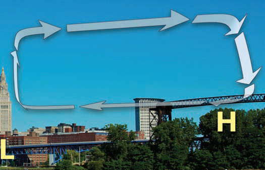
2. The outlying areas are generally cooler because they are more likely to contain vegetation for shading and near-surface water, which absorbs insolation for latent heat rather than sensible heating. Outlying areas also have less human-generated waste heat.
3. This phenomenon is known as the urban heat island (UHI). Urban-rural temperature differences usually peak in the evening hours, after a day of surface heating and busy human activities that generate the urban heating. The UHI is responsible for some of the modern observed increase in surface temperatures.
4. This urban-caused circulation of air can redistribute heat and pollution from the city center to outlying suburban and rural areas. Polluted air can be lifted out of the urban area, flow laterally, and descend into outlying areas. Higher pressure in the outlying areas may trap pollution near the ground. As with the sea breezes and valley breezes, the urban heat island can be diminished by storms and other strong air-circulation patterns.