How Does the Coriolis Effect Influence Wind Direction at Different Heights?
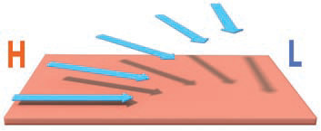
PRESSURE GRADIENTS INITIATE MOTION in the atmosphere, but the actual direction in which the air moves is greatly influenced by the Coriolis effect. Close to the surface, where friction with the planetary surface is greatest and wind velocities are lowest, the pressure gradient dominates. Higher in the atmosphere, winds have higher velocities and the Coriolis effect dominates. The resulting patterns of airflow can dominate weather systems.
Why Do Wind Speed and Direction Change with Height near the Surface?
The direction in which air moves is determined by three factors: 1) the pressure-gradient force (winds blow from higher pressure toward lower pressure); 2) the Coriolis effect, which appears to deflect objects moving across Earth's surface, and 3) friction with Earth's surface, which cannot change direction by itself but can interact with the other two forces to change the speed and direction of wind. Friction becomes less important upward.
1. This figure shows how wind direction can change upward, from the surface to well above the friction layer. Winds are fastest higher up and progressively slower down closer to the surface. This example is in the Northern Hemisphere.
2. The pressure-gradient force, caused by the pressure gradient between a high (H) and a low (L), causes winds right above the surface to blow from higher pressure to lower pressure, in an attempt to even out the pressure gradient. Even though friction is strong near the surface, it merely slows the wind; it does not by itself change the wind's direction.
3. Higher up, friction is decreased, so winds are stronger. Since the Coriolis effect is proportional to wind speed, it begins deflecting air to the right (or to the left in the Southern Hemisphere). This causes successively more and more deflection with height.
4. At some height, the deflection will be such that the winds flow parallel to the pressure gradient — no longer from higher to lower pressure. Further turning cannot happen because if it did, the flow would be going against the pressure gradient, from lower pressure toward higher pressure. The height at which this flow neither toward nor away from lower pressure (i.e., parallel to isobars) occurs is called the geostrophic level. It typically occurs when air pressure is about half that at the surface (i.e., the 500 mb level).
5. To illustrate how wind direction can change with altitude, examine what commonly happens to a balloon as it ascends from the surface. The red arrows indicate wind direction and the inset maps show isobars between high- and low-pressure areas. Follow the balloon's progress from the surface upward, starting with the text below.
6. Right after the balloon takes off, in Position 1 on this figure, the pressure-gradient force and friction are the primary factors that affect wind speed. The balloon will go from higher pressure to lower pressure, across the pressure gradient as it rises. Friction slows the circulation in this lowest part of the friction layer, which is called the surface boundary layer.
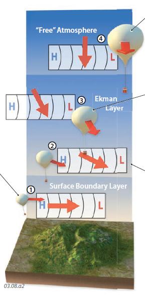
7. In Position 2, the balloon has risen high enough from the surface that friction becomes weaker. This weakening of friction speeds up the balloon, and it also increases the impact of the Coriolis effect, because faster winds cause an increasing rightward deflection. This causes the balloon to move somewhat to the right of the direction that the pressure-gradient force would otherwise take it. The balloon therefore begins to travel more to the right as it rises.
8. As the balloon continues to rise, near Position 3, it experiences less and less friction, so the winds strengthen with height. This makes the Coriolis deflection even stronger with increasing height. The winds and the balloon move even less from higher pressure to lower pressure, instead turning at an angle to the isobars. This layer characterized by a turning of the winds with height (shown in Positions 2 and 3) is called the Ekman layer. It exists from about 100 m to about 1–2 km above the surface. The Ekman layer is a part of the friction layer.
9. Eventually, the balloon will ascend to a height (1–2 km above the surface) at which friction becomes negligible (above the friction layer). At that point, only the pressure-gradient force and the Coriolis effect are important in dictating flow. The wind speed is faster because of the reduced friction, so the Coriolis effect continues to pull the balloon to the right until it no longer flows toward lower pressure. Instead, the wind is perpendicular to the pressure-gradient force and parallel to isobars. This type of wind, flowing parallel to the isobars, is called a geostrophic wind.
How Do We Depict Upper-Level Wind Patterns?
1. This map shows another way to represent pressure in the atmosphere, by contouring the height (in meters) at which 500 mb of pressure is reached. The contour lines represent lines of constant height and are called isohypses. Surface pressure is about 1000 mb, so the 500 mb level represents the height bounding the lower half of the atmospheric mass. This height is also generally considered to be the lowest level at which geostrophic winds occur. The higher the 500 mb level occurs, the higher the pressure. These “constant pressure surface maps” are used by the National Weather Service and other organizations in making weather maps, because of the need for constant pressure surfaces in the aviation industry.
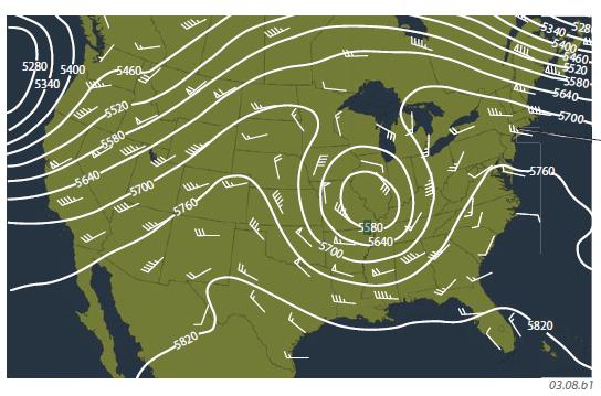
2. This map also has symbols, called wind barbs, that show the direction and velocity from which the wind is blowing. The barb is parallel to wind direction, and each flag on the barb represents 50 knot (kt) winds (two flags indicate winds of 100 knots). Each full hash mark designates 10 kt, and each half-barb represents 5 kt. The wind barbs on this map show that winds generally flow parallel to the isohypses (they are geostrophic).
Which Way Does Air Flow Around Enclosed High- and Low-Pressure Areas Aloft?
Aloft, in upper parts of the troposphere, well above the friction layer, wind directions are dominated by the Coriolis effect and so are typically geostrophic. As a result, air circulation can be nearly circular around upper-level lows and highs. In situations in which the flow is nearly circular, the low or high pressure typically lasts for a longer period of time than in cases where the flow is not enclosed as tightly, such as in an upper level ridge or trough of pressure. Closed circulations at the 500 mb level or above suggest a strong circulation that is not likely to dissipate soon. The figures below are map views.
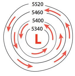
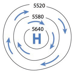
Northern Hemisphere
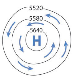
For low pressure, the pressure-gradient force pushes air into the low from all directions, but at high altitudes the Coriolis effect deflects this air until it parallels the isohypses. In the Northern Hemisphere, the deflection into a low is to the right, so the upper-level flow goes counterclockwise around the enclosed low-pressure area. This type of curved flow is called gradient flow.
For a high-pressure area, the pressure-gradient force pushes air out of the high in all directions, but the Coriolis effect deflects winds to the right, parallel to the isohypses. Due to this deflection, the gradient flow goes clockwise around the high-pressure area.
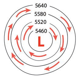
Southern Hemisphere
Similar processes occur around lows in the Southern Hemisphere. Air pushed into the low from all directions is deflected to the left by the Coriolis effect, until it flows parallel to the isohypses. The gradient flow therefore goes clockwise around a low in the Southern Hemisphere.
In the Southern Hemisphere, deflection of air moving out from a high is to the left, causing the gradient flow to be counterclockwise around a high. In both hemispheres, pressure gradients tend to be weaker around highs, which are typically associated with fair weather, than around lows, which are commonly associated with stormy and windy weather.