What Are Some Significant Regional Winds?
DIFFERENCES IN AIR PRESSURE cause a variety of regional to local wind conditions, such as those associated with storms, which are discussed in the chapter on weather. Some local winds are not so much related to weather systems as they are to differences in pressure that tend to occur at certain times of the year or after the establishment of an area of high pressure. These local to regional winds have interesting names, like Chinook winds or Santa Ana winds, and can have profound impacts on people.
What Is a Chinook Wind and Where Do They Form?
The term Chinook originated in the Pacific Northwest and can refer to several types of winds. The most common usage is for a warm, dry wind that blows down the flanks of a mountain range. Chinooks are so warm and dry they are called “snow eaters,” for the way in which they can cause a sudden melting of snow and ice on the ground. The onset of a Chinook wind can cause a sudden rise in temperatures, especially during the winter. A Chinook in Loma, Montana, caused temperatures to rise from ?48°C (?59°F) to 9°C (49°F) within a 24-hour period, the most change recorded for a single day in the U.S. In Spearfish, South Dakota, a Chinook off the adjacent Black Hills caused temperatures to rise 27 C° (49 F°) in two minutes, the world's fastest rise in temperature ever recorded!
1. This figure depicts the formation of a Chinook wind. The process begins when winds push moist air against the windward side of a mountain, where windward refers to the side toward which wind is blowing (the left of the mountain in this figure). As the moist air rises up the mountain, it cools, causing the formation of clouds, a process that also releases latent heat. The heat warms the air, which continues rising toward the mountain peaks.
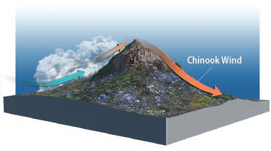
2. Once the air reaches the peak, it begins flowing down the other side — the leeward side, of the mountain (the side opposite the windward side). As the air descends, it continues drying out and is compressed and heated. It is also warm from the release of latent heat on the windward side. The warm, dry air descends from the mountain and spreads across the adjacent lowland, forming a Chinook wind.
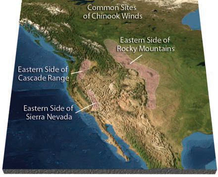
3. This map shows the locations where Chinook winds are relatively common. As expected, Chinooks occur on the leeward side of mountain ranges (prevailing winds are from the west to east in this region), in Alaska, and elsewhere.
How Do Katabatic Winds Affect Polar Regions?
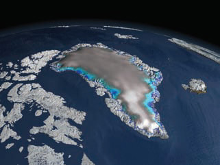
1. On the previous two pages, we introduced the term katabatic wind for a wind that blows downslope, forming a cool mountain breeze. More regional and pronounced katabatic winds affect Antarctica and Greenland, both of which have a high central landmass surrounded by ocean. Air over the middle of the landmasses is very cold and so very dense, flowing off the central topographic highs and down the icy slopes.
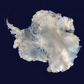
2. These two perspective views show that Antarctica (on the left) and Greenland (on the right) both have a broad, high area centered in the middle of the ice. Katabatic winds blow down off these high areas in all directions. These winds are especially strong where they are channeled down valleys, such as the famous Dry Valleys of Antarctica, so named because strong katabatic winds have stripped most ice off the land surface.
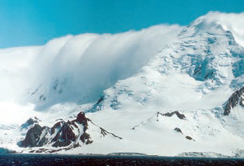
3. Katabatic winds in Antarctica generally involve cold but dry air, but they can interact with clouds along the coast, sometimes creating stunning effects as the cold air and clouds spill off the highlands, similar to the scene in the photograph above.
How Do Santa Ana Winds Affect Southern California?
Winds in Southern California typically blow from west to east, bringing relatively cool and moist air from the Pacific Ocean eastward onto land, especially in areas right along the coast, like Los Angeles and San Diego. These coastal cities also often have onshore sea breezes during the day and offshore land breezes at night. At other times, however, regional winds, called Santa Ana winds, blow from the northeast and bring dry, hot air toward the coast, causing hot, uncomfortable weather and setting the stage for horrendous wildfires.
Setting of Santa Ana Wind
1. Santa Ana winds are regional winds that blow from the northeast, typically developing during spring and fall, when high pressure forms over the deserts of eastern California and Nevada. Circulation of air associated with the area of high pressure pushes winds south and westward, toward the coast, in marked contrast to the normal onshore flow. This air is coming from the Mojave Desert and other desert areas to the north and east, so is very dry. The winds bring this dry air southwestward across the very dry Mojave Desert and toward the coast.
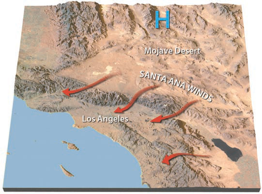
2. Santa Ana winds from the Mojave Desert are partially blocked by the mountains on the northern and eastern sides of Los Angeles. The winds spill through mountain passes, such as Cajon Pass northeast of Los Angeles, and are funneled down the canyons and into the Los Angeles basin. The funneling effect causes winds to be especially strong within the canyons. As the air moves from higher deserts to the northeast and down toward Los Angeles, the air compresses and heats up. As a result, during an episode of Santa Ana winds, the coastal areas of Southern California experience much hotter and drier weather conditions than are normal. Due to this behavior of air flowing from high to low areas, Santa Ana winds are considered to be a type of katabatic wind.
Effect on Wildfires
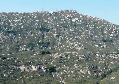
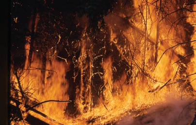
1. The hills and mountains of coastal Southern California receive enough precipitation to be covered with thick brush, such as oak, or by forests at higher elevations. During a Santa Ana wind, the fast winds dry out the brush, trees, and other vegetation, making it extremely prone to wildfires.
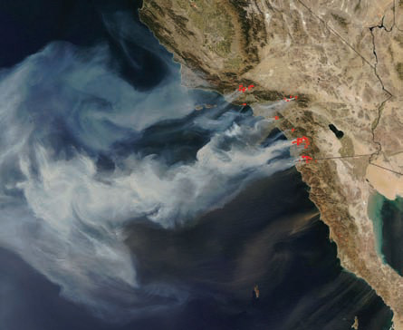
2. The hills and mountains of Southern California experience some of the most spectacular but devastating wildfires of any place on the planet. Santa Ana winds push these fires southwestward, toward the cities and through neighborhoods in the foothills. Wildfires associated with Santa Ana winds can burn thousands of homes, causing hundreds of millions of dollars in damage. Pushed by the strong winds down the canyons, the fast-moving fires can cause the deaths of firefighters and people who did not evacuate in time.
3. This amazing image from NASA combines a satellite image of Southern California and adjacent states with the locations of fires (shown in red), as determined by processing a different kind of satellite data. The smoke produced by a number of fires trails off across the Pacific Ocean, clearly showing Santa Ana winds blowing from the northeast. These fires occurred in October of 2007 and killed 9 people and injured dozens of others, destroyed more than 1,500 homes, and burned more than 2,000 km2 of forest, brush, and neighborhoods. The region was declared a federal and state emergency, as more than one million people were evacuated, the largest such evacuation in California history. The especially large amount of destruction from these fires was due to the combination of strong Santa Ana winds and a prolonged drought that had dried out the natural vegetation.