Natural Environment
Jamaica has a rich and varied natural environment. The island's land features range from low-lying coastal plains to the Blue Mountain crests reaching nearly 7,500 feet (2,286 meters) in elevation. Part of the island is a lush tropical paradise, and some areas are dry much of the year making them almost desertlike in appearance and character. The island is rich in a variety of resources, including bauxite (the ore from which aluminum is made), and suffers from occasional natural hazards, including devastating hurricanes.
ORIGIN OF A CARIBBEAN ISLAND
With a few exceptions, the islands of the West Indies are actually the summits of a range of submarine volcanic mountains. Over millions of years, this range has undergone episodes of uplift followed by subsidence (sinking or settling to the bottom), leaving all but the highest peaks covered by water. Jamaica's Blue Mountain range is the oldest and highest of the mountains on the island.
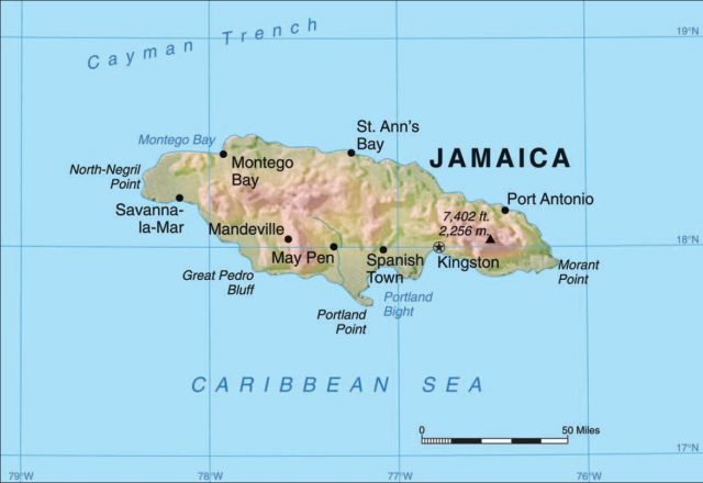
During the period of most active uplifting and folding, the Blue Mountains pushed up to over 7,000 feet (2,134 meters). Blue Mountain Peak, the highest point in Jamaica and one of the highest peaks in the entire Caribbean region, towers 7,402 feet (2,256 meters) above the island's surrounding terrain. Four other peaks rise above 6,000 feet (1,830 meters). They are Sugar Loaf, the country's second highest point, with an elevation of 7,055 feet (2,150 meters), and High, Mossman's, and Sir John peaks. Only the highest mountains of the Dominican Republic (over 10,000 feet, or 3,048 meters) and Haiti (over 9,000 feet, or 2,743 meters) stand taller than the Blue Mountains of Jamaica.
On a clear day, the range is visible from nearly all points on the island. Seen from a distance, it appears blue in color, as is the case with the Blue Ridge Mountains in the central Appalachians. In both locations, atmospheric moisture creates a haze that gives the ranges a blue cast.
During periods of submergence under the sea, thick limestone deposits were formed. Limestone is a sedimentary rock that is created from the remains of sea creatures, including coral. Yellow limestone was formed first and was overlaid by white limestone layers. More than half of Jamaica's surface is covered by white limestone overlying yellow limestone. Over time, dissolving of the white limestone led to the development of depressions (solution basins) and extensive cave networks.
Some depressions have an almost circular shape and have filled-in areas of bright red earth (bauxite). Bauxite is the source of aluminum metal. Sizes of individual deposits vary from small pockets to large basins of more than 309 acres (125 hectares) and in thickness from several feet to more than 98 feet (30 meters). Bauxite mining is the second-largest industry in Jamaica.
Waters of the rivers flowing through the white or yellow limestone or red earth material take on the color of the land: Some are nearly white and others are yellow to orange. Several thousand years ago, Phoenician voyagers from the eastern Mediterranean region sailed to some undocumented distant land. When they returned, they told of a land where rivers flowed with waters resembling “milk and honey.” Could they have reached Jamaica 2,000 years before Columbus? Some historical geographers think so.
PHYSICAL REGIONS
Jamaica can be divided into three physical regions: an eastern mountainous region, a central and western plateau, and coastal lowlands. Two-thirds of the country is covered with soft, porous limestone.Nearly half of Jamaica is more than 1,000 feet (304 meters) above sea level, with elevations rising gradually from west to east and culminating in the Blue Mountains.
Eastern Mountain Region
In the east, the Blue and John Crow mountains dominate the physical landscape. The Blue Mountain range is formed from a central ridge of metamorphic rock (rock hardened under heat and pressure) running in a northwest to southeast direction with many long spurs jutting north and south. The John Crow Mountains, lying to the north and east of the Blue Mountains, are formed from a strongly tilted limestone plateau, which rises to elevations of more than 3,700 feet (1,138 meters). The Rio Grande River separates the two mountain ranges. This mountainous region is picturesque and rugged, and it is here that the famous Blue Mountain coffee is grown.
Central and Western Plateau Region
Sculpted limestone blocks and other karst formations dominate the central and western plateau region. Karst is formed by solution weathering (when limestone rock is chemically dissolved by water) and erosion. The results of this unique kind of rock decomposition include sinkholes, caves and caverns, disappearing streams, and haystack-shaped hills, all of which are typical features of a karst landscape. High limestone plateaus separated from each other by north- and south-flowing streams and by underground rivers dominate the center of the island. Hector's and Cave rivers are notable examples of rivers whose flow is partially underground. The Mocho, Dry Harbor, May Day, Don Figueroa, and Santa Cruz mountains are all found in the central part of the island. They range in elevation from 1,500 to 2,200 feet (457 to 610 meters), with several peaks. To the west of the central plateaus lies the rugged terrain of the Cockpit Country, a truly dramatic example of karst topography.
The Cockpit Country
The Cockpit Country is identified by its varying landscape of gently rolling soil-covered plains to a rough jumble of deep depressions, isolated towers, and pointed hills. It is the result of karst (solution) weathering and erosion of white and yellow limestone groups, which vary considerably in purity, hardness, and depth. The Cockpit Country represents an especially well-developed topography of bowl-shaped depressions, called cockpits for their resemblance to cockfighting pits, and cone-shaped peaks. It is recognized globally as the type locality for this pattern of aboveground karst. Until well into the twentieth century, this area, because of its rugged terrain, was very isolated. Many escaped slaves sought refuge in the Cockpit Country, where they came to be known as “Maroons.”
Coastal Lowlands Region
Coastal lowlands are formed from stream deposits of rivers flowing both to the north and south coasts of the island. The plains are narrow on the north coast but elsewhere extend far inland to the limestone foothills. Major lowlands exist in the southern half of the island, where they are often associated with coastal mangrove (a type of tree or shrub) swamps. This land-building process is continuing along the south coast, with a large fan delta rising at the mouth of the Yallahs River and an extensive submarine shelf building up seaward.
Many of the Jamaica's 120 rivers are dry for most of the year, but they fill rapidly during periods of heavy rainfall, causing extensive local flooding. Three large rivers are the Rio Grande, which collects much of the drainage of the northeast slopes; the Yallahs River, which drains to the southeast; and the Black River, which originates in the Cockpit Country and flows to the southwest coast. The Black River is the largest river and the only navigable stream on the island. The Black River Lower Morass, located near the mouth of the river, is recognized as an internationally significant wetland. This largely freshwater swamp covers 14,085 acres (5,700 hectares) and contains a mix of peat lands, mangrove forests, and limestone islands.
SOILS
The most important influences on soil development in Jamaica are the parent materials (rocks and stream deposits), climate, and vegetation. There are four major soil groups: upland plateau soils, alluvial soils (soils containing material deposited by running water), highland soils, and a catchall category of “others.” Upland plateau soils, terra rossa (red limestone soil) and rendzina (black marl; marl is a deposit with a large amount of calcium carbonate), account for 64 percent of the island's soils. Rendzina is a clay soil formed over yellow limestone and marl. Moderately deep and relatively fertile, they have good agricultural potential. Terra rossa, formed over white limestone, are poorer soils that are low in nitrogen, phosphorus, and potassium. Although they contain substantial organic matter, they also have high concentrations of iron and aluminum, giving a distinctive brownish-red “brick” color to the soils. Alluvial soils are loams, sands, and gravel deposited by streams and make up about 14 percent of the country's soil. They are the most fertile and productive soils on the island. Because they are stream-deposited, alluvial soils are located on the coastal plains, inland basins, and valleys. Highland soils, formed in mountainous terrain, account for another 11 percent of Jamaica's soil and are concentrated in the Blue Mountains. The highland soils tend to be porous and susceptible to leaching (the removal of nutrients) and erosion under conditions of high rainfall.
WEATHER AND CLIMATE
Jamaica has a tropical climate that is somewhat moderated by the cooler waters of the surrounding sea and highlands of the interior. Average daily temperatures along the coast and lowlands average about 79°F (26°C) and range only about 4°F (about 1 to 2°C), from a seasonal low of 78°F (26°C) in February to a high of 82°F (28°C) in August. Temperature extremes also do not have a great range. Rarely do they climb into the 90s (low 30s Centrigrade) or drop into the 50s (low teens Centrigrade). Humidity is high, however, averaging more than 75 percent throughout most of the year and often reaching 100 percent. The moist air makes temperatures feel “hot and muggy.” Similar conditions exist during the summer months in the Southeastern United States. Jamaica's mountainous interior has somewhat lower temperatures and humidity. In general, the temperature decreases about 3.5°F (1°C) with each 1,000-foot (300-meter) increase in elevation. Nighttime cooling is also more pronounced at higher elevations.
Mean annual rainfall over the island is about 78 inches (1,980 millimeters). The main dry season lasts from December to April, and peaks in rainfall occur in May and October.Much of the rainfall results from the moisture-laden northeast trade winds, which, when forced upward over the mountain ranges, deposit most of their precipitation on the northern slopes. The southern half of the island experiences a rainshadow effect, receiving notably lower amounts of rainfall. A similar condition exists in Washington, Oregon, and northern California. The windward (western) slopes of the Cascade Mountains are extremely moist, but east of the mountains, desert conditions prevail. Rainfall on the northeastern slopes of the Blue Mountains ranges from 100 to about 200 inches (3,000 to 5,000 millimeters) a year. On the rainshadowinfluenced south central coastal plains of St. Catherine and Clarendon parishes, less than 60 inches (1,500 millimeters) of rain falls each year. In the tropical climate, however, the evaporation rate is high, so much less moisture is actually available for plants. Some locations have an almost desertlike vegetation cover. The much drier conditions on the southern half of the island have important consequences for community water supplies and agriculture.
Jamaica's wet north, drier south, and varied mountainous pattern of precipitation are reflected in the types of natural vegetation occurring on the island. Dense tropical forest occurs under natural conditions in areas of high rainfall areas, and mixed forest, grasslands, and scrub (stunted trees and shrubs) grow in areas of low rainfall and high evaporation.
NATURAL HAZARDS
Jamaica's greatest natural hazards are hurricanes, flooding, earthquakes, and landslides. The island is regularly the victim of tropical storms and hurricanes. Strong winds and high amounts of intense rainfall, which often contribute to severe flooding and massive landslides, characterize these often violent weather events. The hurricane season lasts from July to November. Nearly 70 hurricanes (sustained winds above 74 miles per hour, or 119 kilometers per hour) and tropical storms (39 to 73 miles per hour, or 63 to 118 kilometers per hour) have struck the island between 1886 and 2003.
Hurricane Gilbert was one of the strongest Atlantic hurricanes ever recorded. The deadly storm roared into the Caribbean Sea and approached Jamaica on September 12, 1988, with sustained winds averaging 75 miles per hour (121 kilometers per hour) and gusts up to 127 miles per hour (204 kilometers per hour). Barometric pressure continued to drop and winds intensified as the storm struck Jamaica.
Atmospheric pressure ultimately dropped to 888 millibars, which is the second-lowest pressure ever recorded for an Atlantic hurricane. Screaming winds reached 180 miles per hour (290 kilometers per hour), making it one of the most intense Atlantic hurricanes in recorded history. Gilbert devastated Jamaica as it raked the entire length of the island, killing an estimated 50 people and affecting another 810,000. Nearly everyone on the island suffered some damage and loss.
Jamaica lies near the northern edge of the Caribbean Plate—a huge mass of Earth's crust—that is thought to be moving in an east-northeasterly direction with respect to the North American Plate. As a result of this movement, earthquakes and the accompanying landslides are common in Jamaica and pose a real threat to life and property. The country experiences up to 200 detectable earthquakes a year. Records of earthquakes in Jamaica date back to the sixteenth century.
Port Royal Earthquake
The Port Royal earthquake of June 7, 1692, is perhaps the most famous of the early earthquakes. Just before noon, a violent quake struck the densely populated city of Port Royal (the city was located on a sand spit, a piece of land jutting into the sea, just southeast of present-day Kingston).
In less than five minutes, three shocks, each of greater intensity, caused the sea to recede and then rush back with tremendous force. A wave six feet (1.82 meters) high swept the bay, and much of the city sank into the sea. Earthquake tremors and resulting land subsidence (settling or sinking) destroyed 90 percent of the city's buildings and most of the ships in the harbor. Between 1,500 and 2,000 of the city's 6,500 people were killed by the earthquake and the accompanying tidal wave.
Other major earthquakes occurred in Jamaica in 1712, 1722, 1744, 1812, 1907, and 1957. The earthquake of January 14, 1907, was particularly destructive, leveling both Kingston and nearby rebuilt Port Royal. Kingston, then a town of 46,000, was reduced to rubble in a matter of minutes, and fires raged for up to four days after the quake. More than 800 people died on that day. After the devastating quake, Kingston was rebuilt. The city now is home to nearly onethird of the island's population, which clearly is at risk from future earthquakes.
PLANT AND ANIMAL LIFE
Natural vegetative patterns have been strongly modified by agriculture, mining, and forest industries. Had humans not intervened, the northern coast and the central plateau region would have remained thickly forested. The drier southern plains would have supported a natural vegetation cover of grass, sedges, cacti, acacia scrubland, and scattered tropical trees such as the lignum vitae and cottonwood.
Human Activities and Vegetation
For centuries, Jamaicans have cut mahogany and other cabinet woods in the mountain forests, leaving little of the natural woodland still standing. Only an estimated 6 percent of virgin forest remains.Mountains that at one time were entirely covered by tropical forest now show signs of accelerating deforestation and soil erosion. Hurricanes, floods, landslides, and especially the mining of bauxite, building of tourist resorts, and encroaching coffee plantations, are blamed for the loss of woodlands. Yet pockets of relatively undisturbed vegetation, now in protected reserves, do remain on the island.
Jamaica has more than 128 protected sites that encompass well more than 386 square miles (1,000 square kilometers) of land area. Blue Mountains/John Crow Mountains National Park was established in 1990 to provide stricter protection for government land and designated forest reserves. The park covers 313 square miles (809 square kilometers) and houses the watershed for the city of Kingston and all communities on the eastern third of Jamaica.Much of the Cockpit Country, an area of 166 square miles (430 kilometers), has forest reserve status. Other important forest and wildlife preserves are the Negril Environmental Protection Area, Portland Bight Protected Area, Montego Bay Marine Park, and the Black River Lower Morass.
Lush, diverse vegetation characterizes Jamaican plant life in the less developed areas. The island boasts an extraordinary number of endemic (native) plant species. Among the world's islands, Jamaica ranks fifth in the diversity of native plants and animal species. More native ferns (100) are found in Jamaica than on any other Caribbean Island. Of the 3,000 flowering plant species in Jamaica, more than 750 are native to the island and not found anywhere else. Because of its climate, the island is especially hospitable to orchids. There are 260 species of orchids, 60 of which are native to the island.
They vary from very tiny to a diameter of about four inches. Native trees include mahogany, cedar, ironwood, logwood, sandalwood, rosewood, ebony, coconut palm, palmetto palm, and pimento. The blossom of blue lignum vitae is Jamaica's national flower. Introduced ornamental trees such as the red poinciana, colorful bougainvillea, yellow poui, and hibiscus are common throughout the settled areas of the island, providing a year-round spectacle of color.
Animal Life
Jamaica, like a number of the other Caribbean islands, has a highly diversified bird population. The island has more than 200 bird species, 28 of which are native. Common birds include parrots, cuckoos, hummingbirds, and at sea, pelicans. The national bird is the swallowtail hummingbird, also called the “doctor bird.” Reptiles are numerous, with 27 different species native to the island. Human activity has severely reduced natural habitats, and as a result, most of the small native mammals have disappeared or are endangered.
There are no large mammals. The only native land mammal is the endangered Jamaican hutia, or coney, a large brown rodent resembling a guinea pig. The Blue Mountain/John Crow Mountains National Park is a last refuge for conies as well as home to the giant swallowtail butterfly. The mongoose, introduced from India in the nineteenth century to control snakes in the sugar fields, is seen in the wild. It is considered a pest, because it eliminated the snakes and turned to eating chickens.
Though small in size, Jamaica boasts an incredible variety of terrain, vegetation, and animal life that is unique and special. Jamaicans see ecotourism as a growing industry, through which people can come to the island and enjoy the abundance of nature, which is protected, preserved, and enhanced.