Physical Landscapes
Although we often speak of Cuba as one island, Cuba is actually an archipelago, or group of islands, whose total combined area is 42,803 square miles (110,860 square kilometers). Cuba is the largest island in this archipelago, making up 95 percent of the total land area of the island group. The second largest island, Isla de la Juventud (Island of Youth), is 864 square miles (2,230 square kilometers), which is about 2 percent of Cuba's total land area. There are about 1,600 additional islands called islets (small rocky islands) and cays (low coral islands). Small archipelagos of cays make up most of the remaining 3 percent of Cuba's territory.
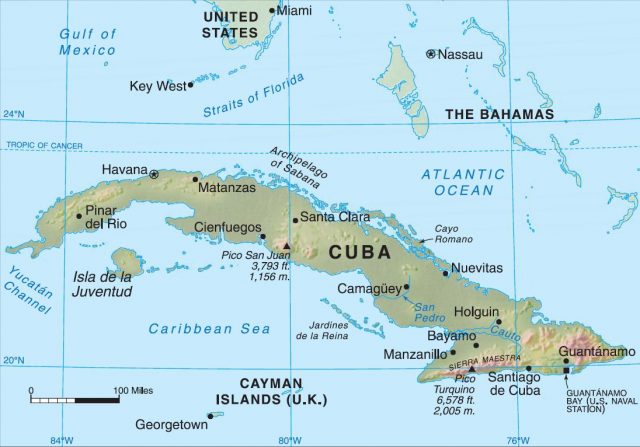
The country's total area is almost identical to that of Ohio. Cuba extends about 780 miles (1,250 km.) in a somewhat curved east-west direction. This is about the same distance as between New York City and Chicago. The narrow width varies from 25 to 120 miles (40 to 195 kilometers).
Cuba lays astride principal maritime approaches to the Atlantic Ocean, the Gulf of Mexico, and the Caribbean Sea. These approaches are the Straits of Florida to the north, the Windward Passage to the east, and the Yucatan Channel to the west. These narrow waterways (straits) have played key roles in the history of Cuba. For example, when Cuba was a Spanish colony, Spanish fleets carrying gold and other precious cargo were vulnerable to attack as they converged on the straits. As a result, in the late sixteenth century Spain built heavy fortifications around Cuba's harbors, so that the fleets could seek protection as well as supplies. More recently, the narrowness of the Straits of Florida has encouraged an exodus of Cubans on rickety boats and rafts to the United States.
SUBMARINE PLATEAU AND ROCK TYPES
Geologically, most of Cuba is the exposed portion of an undersea plateau. A plateau is a mass of rock with an elevated tablelike surface. Limestone, or calcium carbonate, is the most common rock on the plateau. It is a sedimentary rock created from the cementing of shells of dead sea-dwelling organisms. Most of these organisms are tiny plankton, single-celled organisms that float near the surface of the ocean when they are alive. As they die, their remains (sediments) slowly settle to the bottom of the ocean where they harden into thick layers of limestone. In addition to limestone, Cuba has thin layers of other sedimentary rocks, including sandstone, shale, and mudstone. These rocks formed from hardened deposits of sand, silt, and clay sediments washed into the sea from continents.
Seafloor deposition created all of these sedimentary rocks between 15 million and 130 million years ago. The rocks rested as horizontal layers on the bottom of the sea. The sea was between the North American and Central American lithospheric plates. (Lithospheric plates are large sections of Earth's rocky outer layer.) They have been converging for millions of years. Their collision forced rocks on the seafloor between them to rise gradually as a platform and to expose Cuba about 21 million years ago. Folding, faulting, volcanism, and earthquakes accompanied this uplift. Consequently, Cuba's land surface does not have the flatness of an ancient seafloor. Geologists believe that plate convergence and uplift are still in progress, as occasionally the eastern end of the island experiences powerful earthquakes.
Karst
One of the extraordinary aspects of Cuba's landforms is its karst topography. Karst is the Slavic name of limestone areas in Slovenia and Croatia. Geologists use this term to describe landforms of limestone areas' peculiar surface features and where most or all water drainage occurs through underground channels. Cuba has some of the world's most picturesque karst landscapes.
Karst topography forms wherever acid in surface streams or groundwater dissolves soft limestone. Sinkholes (hoyos) are saucer-shaped depressions where surface water collects, sinks, and disappears as groundwater. The acid water filters down from the sinkholes and dissolves the limestone beneath to create underground networks of streams. These streams dissolve more limestone to form cave systems.
Caverns are the largest caves. Sometimes roofs of caverns become fragile and collapse, leaving enclosed basins (poljes). When several caverns close to one another collapse, they create large, flat-bottomed depressions with only steep-sided, coneshaped hills (mogotes) left standing. Cotilla Caverns, about 15 miles (24 kilometers) southeast of Havana, are probably the most frequently visited caves in Cuba.
Caverns in Cuba are attractive to tourists because of their natural beauty. However, speleologists (people who study caves) have not adequately explored most of the island's caves. Moreover, people have abused many of them. For example, Cuba's military uses many of the largest caverns to store armaments, explosives, and chemical products. Additionally, agricultural and industrial enterprises discharge tons of wastewater into many caves and sinkholes. Ranchers even use some caves to dispose of dead cattie. These practices not only destroy the beauty of the caves, but they also threaten sensitive habitats of plants and animals and pollute the groundwater that travels through the caves.
Limestone Plain
Limestone forms a rolling lowland plain that covers about 60 percent of the island's surface. The plain begins at the base of the Sierra Maestra (a mountain range on the east end of the island), narrows as it arcs north of the foothill town of Santa Clara, and ends at the base of the Sierra de los Organos (a mountain range on the west end of the island). The plain is not perfectly level. To the north, stepped limestone terraces descend quickly toward knife-edged sea cliffs. To the south, the plain slopes gently toward the soft contours of beaches and mangrove swamps.
Low hills of hard igneous and metamorphic rocks break up the plain in several places. Low, steep-sided hills of limestone also are present. The Zapata Peninsula, with its many lagoons, lakes, and swamps, is also a distinctive lowland feature.
MOUNTAINS
About 25 percent of Cuba's surface is mountainous. The island's mountains were formed by the collision of tectonic plates. Compression causes two general types of mountains: folded and fault-block. Compression created folded mountains in Cuba when the horizontal layers of sedimentary rock on the bottom of the sea gave in to the pressure of converging plates: up-folds became ridges, down-folds valleys. Imagine hands moving together on a flat tablecloth; this movement creates compression and the tablecloth folds into “ridges” and “valleys.” Compression and folding of Earth's surface occur in a similar manner.
Compression also caused huge blocks of rock on either side of faults (breaks in Earth's crust along which movement occurs) to move up or down, creating fault-block mountains. Magma (molten rock formed deep inside Earth) moved into the faults and onto the surface and cooled to form various types of igneous (volcanic) rocks in the mountains.
There are three mountainous areas in Cuba. Eastern Cuba has the highest mountains, which include the Sierra Maestra and the Baracoa massif. (A massif is a very rugged elevated area composed of numerous mountain ranges.) The Sierra Maestra is a fault-block mountain range that rises steeply out of the sea. Many dark-colored volcanic rocks make up this range. The Sierra Maestra includes Cuba's highest peak, Pico Turquino, which rises about 6,576 feet (2,005 meters) above sea level. This magnificent peak provides a view of the Caribbean Sea to the south and, on a clear night, lights glimmering across the Windward Passage in Haiti are visible.
At the very eastern end of the island is the Baracoa massif. The massif's highest summits, which are in the impressive Sierra de Cristal mountain range, rise to about 4,000 feet (1,200 meters). Geologically, the Baracoa massif is a mixture of both folding and faulting. It is made mostly of igneous rock. A narrow valley separates Sierra Maestra and the Baracoa massif. This valley serves as a transportation corridor connecting agricultural towns in the broad Cuato River lowland with coastal ports situated on the eastern end of the island.
The second mountainous area is in central Cuba, south of the city of Santa Clara. Traveling south from Santa Clara, there are low, parallel limestone ridges in which many caves and other karst phenomena have developed. Still farther south, at the edge of Cuba's south shore, is the Sierra del Escambray. This fault-block mountain range dominates the area. Its erosion-resistant summits rise to about 3,500 feet (1,100 meters).
The third mountainous area, Cordillera de Guaniguanico, which is in the western end of the island, includes two mountain ranges—Sierra del Rosario and Sierra de los Organos. The highest summit, which is in Sierra de los Organos, is Pico Grande at about 3,000 feet (900 meters) in elevation. However, most elevations in both mountain ranges are well below that height. Despite the lower elevations, the western mountains are very picturesque because of their highly developed karst features.
Throughout Cuba's history, gold, manganese, nickel, chromium, and iron ore have been mined from its mountains. Because of their rugged terrain, these same mountains also have served as safe havens for the many peoples who arrived on Cuba's shores seeking a new home. For example, before Europeans arrived, successive waves of Indians from other regions invaded Cuba. Each time a new group of invaders arrived on the island, some of the Indians who preceded the invaders managed to flee into the mountains. The same dispersal happened when the Spanish arrived. Additionally, when Fidel Castro began his successful revolt against the Cuban government, he used the Sierra Maestra as his main base of operations.
COASTLINE FEATURES
Cuba's coastline has reefs, cays, and beaches. These three features come from remains of coral polyps (invertebrate animals). Coral polyps are tiny animals that live together in colonies in warm, shallow seawater. When they die, their lime skeletons stay behind to build reefs made of limestone. Coral reefs are hazardous to ships, because they lurk just beneath the ocean surface most of the time (some reefs are exposed at low tide). The remains of an immense number of coral polyps make up a single coral reef. Reefs fringe most of Cuba's coastline, making it dangerous for unwary sailors.
Over time, coral reefs can grow so large that they become low islands or cays. People living in Florida call such islands “keys,” as in the Florida Keys. The Camaguey archipelago, which runs parallel to the main island's north-central coastline, is Cuba's largest cay. Other prominent archipelagos made of low coral islands include Sabana and Canarreos.
Sand grains from skeletons of dead coral polyps make up most of Cuba's beaches. Ocean waves break up coral colonies growing on offshore reefs and wash grains of coral sand—and lesser amounts of broken clam and snail shells and sea urchin remains—onto the beaches. The sun bleaches the tiny pieces of coral and other organisms white, giving most of the island's beaches a white powder texture. The only major exceptions to Cuba's coral beaches are small black-sand beaches that hug the southern coastline of the Sierra Maestra. These beaches form from the weathering and erosion of igneous rocks that make up the mountain ranges.
Lagoons, sea cliffs, gulfs, and bays account for irregularities in Cuba's coastline. A lagoon is a semi-enclosed, shallow body of water that lies between the mainland and offshore reefs and islands. The reefs and islands protect the lagoon from the ocean's strong currents and large waves. Lagoons are unique ecosystems for several interrelated reasons. Lagoon waters are brackish or a mixture of freshwater from streams and salt water from the sea. Many plants and animals, such as coral and sea grass, flourish in quiet lagoon waters. The presence of these organisms feeds a complex food chain that supports different kinds of animals such as fish, crabs, sea urchins, snails, and clams. Some ocean fish use the semi-enclosed lagoon when they are very young for protection from predators in the open ocean.
Lagoons were important to the food supply of indigenous peoples and early Spanish settlers. They are also an important natural resource to Cubans. Unfortunately, due to over-exploitation, important sources of food—fish, turtles, and lobsters— are rare now in some lagoons. Additionally, the government does not have strict pollution laws. As a result, streams drain deadly chemicals from agricultural fields, industrial plants, and sewage into the lagoons.
Sea cliffs exist where the land rises steeply out of the ocean. Waves meet Cuba's limestone shores head-on, where the force of their constant pounding makes indentations that eventually form steep rock pinnacles and sea caves. Sea cliffs make up most of the island's rugged northern shore, usually dropping more than 100 feet (30 meters) to the sea. The southern coast-line has more lowland swamps and beaches than does the northern coastline. The only major exceptions are the southern edges of the Sierra del Escambray and the Sierra Maestra. These mountains have prominent sea cliffs and terraces because they rise out of the sea.
Gulfs are the largest coastal indentations. Gulfs do not make good harbors because their openings are too wide to protect ships from storms. Cuba has three main gulfs: Bataban, Ana Maria, and Guacanayabo. All three align along the island's southern coast. Bays are smaller indentations than gulfs. Many of Cuba's bays are pouch-shaped ports with very narrow openings that expand into spacious sheltered waters. They serve as safe harbors for ships because their bottleneck openings keep out the ocean's storm waves. Many of Cuba's quaint fishing villages, popularized by Ernest Hemingway's book The Old Man and the Sea, are located around harbors. Most of the larger harbors are located on the northern coast, such as Mariel, Havana, Cardenas, Bahia Honda, Matanzas, and Neuvitas. Large harbors on the southern coast include Guantanamo, Santiago de Cuba, Cienfuegos, and Trinidad.
CLIMATE
Climatologists (scientists who study climate) classify Cuba's climate as tropical because it has year-round high temperatures. Nevertheless, the temperatures are mild considering the country's closeness to the equator.
Cuba's temperatures are mild because of the surrounding ocean's influence. In summer, the ocean cools the island by absorbing and storing a lot of the energy it receives from the sun, rather than releasing it into the air. During Cuba's warmest months, May through October, the average high temperature is 89°F (32°C)—moderately warm for tropical latitudes. In Cuba's coolest months, November through April, the ocean warms the island by releasing solar heat it stored during the summer. As a result, the average low temperature is a pleasant 65°F (19°C).
However, in the winter, waves of cold air from North America, which Cubans called el nortes (the north winds), may lower individual thermometer readings around Havana to near 40°F (4°C). Occasionally, storms and heavy seas accompany the north winds along the island's northwest coast.
Mean annual rainfall is 40-45 inches (102-114 centimeters). Cuba's primary source of moisture is the trade winds. These winds pick up and bring moisture from the sea to the land. They blow across the island from the northeast and east. Cuba's mountains block the winds and force them to rise, cool, and form clouds. As a result, mountain areas receive more rain than do areas downwind from them. “Rain shadow” is the name given to the drier downwind areas. For example, Guantanamo Bay receives an annual average 24 inches (61 centimeters) of rainfall, because it is in the rain shadow of the Baracoa massif, located north and east of the bay. The massif, facing the wind, receives more than 70 inches (179 centimeters).
The trade winds distribute rainfall unevenly through the year. Typically, 75 percent of the rain occurs during the warmer months (May through October), when the trade winds blow continually toward Cuba. During the “cool” season (November through March), they weaken and deliver less moisture to the island. The wet-summer trade winds are not always a dependable supplier of moisture. They weaken periodically and cause droughts that can last for several years. A ten-year drought, from 1995 through 2004, the longest in the island's history, hit the island and caused dramatic declines in production of Cuba's major agricultural products: sugar, tobacco, citrus, and coffee.
Tropical Storms and Hurricanes
Every two years, on average, tropical storms and hurricanes add to Cuba's rainfall totals. A tropical storm is weaker than a hurricane. Wind speeds for tropical storms are between 35 and 73 miles per hour (56 and 118 kilometers per hour). When wind speeds are 74 miles per hour (118 kilometers per hour) or greater, the tropical storm becomes a hurricane. Only about 10 percent of tropical storms in the Atlantic and Caribbean region grow to become hurricanes.
Hurricane season runs from June through November, with the worst storms occurring in September and October. Most hurricanes originate south of Cuba in the Caribbean Sea or southeast of the island in the Atlantic Ocean. The island of Cuba sits in the paths of storms originating in both areas. Coastal cities, towns, and villages are most vulnerable. Because of its size and elongated east-west shape, Cuba is struck by hurricanes more often than any other island in the Caribbean and Gulf of Mexico region. Hurricanes affect western Cuba more frequently than eastern Cuba. For example, hurricanes from 1870 to 2001 hit directly or brushed Havana in western Cuba 29 times and Manzanillo in eastern Cuba only 13 times.
Many hurricanes have caused serious damage and deaths in Cuba. The deadliest storm killed an estimated 3,000 people in western Cuba in June 1791. Another storm hit the island in October 1870, killing about 2,000 people. Despite their significance as Cuba's two most deadly storms, they are unnamed, as hurricanes were not given names until 1950. In October 1963, Hurricane Flora, the island's third most deadly storm, hit eastern Cuba with winds up to 120 miles per hour (190 kilometers per hour). This storm killed an estimated 1,000 people and destroyed the country's entire sugar crop.
In recent years, early warnings based on satellite technology have prevented the high death tolls exacted by the storms mentioned previously. In 2008, three devastating hurricanes—Gustav, Ike, and Paloma—struck the island. Material destruction amounted to many billions of dollars in losses. The number of casualties, however, remained surprisingly low. Cuban authorities evacuated over a million residents from the storms' paths. This is a major success considering the country's physical geography.
PLANTS AND ANIMALS
Cuba has one of the world's richest collections of flowering plants. Botanists estimate that more than 8,000 different species of plants and nearly 2,000 species of animals survive in the island's forests, savannas (grasslands), and coastal waters. More than 3,000 plants and about 170 animals are endemic to the island, meaning they exist in Cuba and nowhere else. Endemic plants and wildlife came early to Cuba and lived there long enough to gradually change and become very different from their ancestors. Only two other islands have more endemic species of plants and animals than Cuba—New Guinea and Madagascar.
Forests cover 24 percent of the island, but they once covered 60 percent of its area. During the eighteenth and nineteenth centuries, owners of large landholdings cut down most of the island's tree cover to make room for crop cultivation and livestock grazing. The remaining forest tends to be in relatively remote areas. There are four major forest types in Cuba: semideciduous, mangrove, pine, and tropical rain forest.
Savannas are tropical grasslands. Rural Cubans use the name that the Arawak Indians gave to these areas, “sabana,” meaning “treeless land,” rather than “savanna” for these areas. Like Cuba's forests, savannas were much more widespread before the arrival of Spaniards. Savannas accounted for about 26 percent of Cuba's original vegetation cover, and savannas grasses now grow in many areas where poor agricultural practices have changed rich forest soils into hardpan soils. (Hardpan soils block roots of trees from penetrating into the ground.) Scattered in the savanna are various species of cacti and palms, including the royal palm. Cuba's savanna grasses thrive in a climate with pronounced wet and dry seasons. The grasses also grow well in freshly burned areas. So for hundreds of years, people have used fire to burn areas where trees would ordinarily grow in order to feed grazing animals.
Palm trees are members of Cuba's forests and savannas. They are intriguing plants. They can be either a tree or a shrub and usually have a single woody trunk and large, evergreen, featherlike or fan-shaped leaves growing in a bunch at the top. Cuba has 30 palm species. The palm trees that are associated with savanna soils include the medium-height cana palm and the tall barrigona palm. Cubans call the barrigona palm the big-belly palm because of its distinctive bulge about midway up its trunk.
The stately, fast-growing royal palm tree reaches about 130 feet (40 meters) and grows throughout the island's limestone plain. It is easy to identify because of its slender, silver-gray trunk and crown of dark green fronds (leaves). The royal palm is the symbol of Cuba. It occupies the central position in Cuba's national coat of arms and symbolizes strength. Peasant farmers use the bark of the royal palm to make the walls of their bohids, or dwellings, and they use the tree's fronds as roof thatching.
Rural folk use fibers that encircle fruit pods of the majestic ceiba (silk-cotton tree) to stuff mattresses, life preservers, and sleeping bags. This huge tree is sacred to many tropical people. Although surrounding trees may be cut away, the mighty ceiba is almost always spared.
Xerophytes (from the Latin for “dry plants”) cover about one percent of Cuba's landscape. These plants grow mainly in deserts. However, rain-shadow areas of mountains and dry savannas also have them. The coastal terraces in the rainshadow area of the Sierra Maestra and around Guantanamo Bay are the driest areas in Cuba. Various types of cacti and agaves are common there. The most notable cactus is the tree-sized Dendrocereus nudiflorus, the largest cactus in the world. Dry land soils in Las Villas Province and rain-shadow areas in eastern Cuba harbor this special cactus.
As with plants, a huge variety of species marks Cuba's animal population. The island has 7,000 species of insects, 4,000 of mollusks, 500 of edible fish, and 300 of birds. Most of the wild land animals live in the least disturbed areas—in mangrove swamps of the Zapata Peninsula, in mountainous areas, and on offshore islands.
There are only a few native mammals in Cuba. The jutta, or cane rat, is an edible rodent that weighs as much as 10 pounds (4 kilograms). People have hunted it to near extinction. A small number of jutia hide out in forest preserves and mangrovecovered cays. The almiqui is also in danger of extinction. It is a cat-sized native mammal and resembles a mole. The few almiqui that remain survive in Cuba's eastern mountains. Bats live in Cuba's many limestone caves. People living near the caves collect the bats' droppings (guano) from cave floors and use the droppings as fertilizer.
Reptiles are the most numerous representatives of land animals. The Cuban crocodile is a species of crocodile that only lives in Cuba's freshwater swamps on the Zapata Peninsula and on the Isle de Juventud. The American crocodile outnumbers the Cuban crocodile in these areas. (The American crocodile also lives along the shorelines of all Central American and Caribbean islands and in Florida.) Other reptiles include iguanas, salamanders, 15 poisonous snakes, and a 13-foot (4-meter) long nonpoisonous snake called the rnajd de Santa Maria. The maja (which means nonpoisonous snake) is Cuba's largest snake.
About 300 species of birds live in Cuba. Year-round inhabitants include varieties of hawks, hummingbirds, owls, parrots, pelicans, quails, spoonbills, and woodpeckers. Cuba boasts the world's smallest bird, the bee hummingbird, which lives primarily in the mangrove swamps of the Zapata Peninsula. This tiny bird is slightly larger than a grasshopper. Cuba is also a meeting ground for migratory birds from both the tropical zone in northern South America and temperate zones in North America. Migratory birds—including various warblers and thrushes, and the American redstart, bobolink, and the Cuban trogon—use Cuba as a stopover. Even though it is not a permanent resident of their island, Cubans chose the trogon as their national bird because it has red, white, and blue feathers, the colors of the Cuban flag.