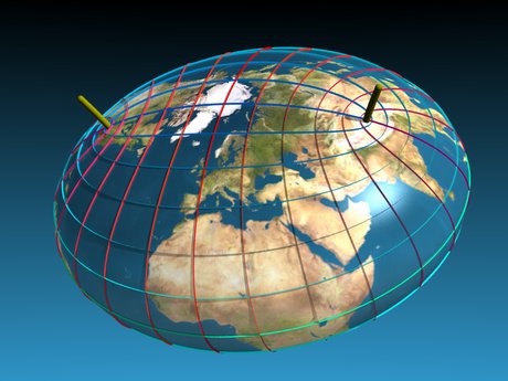
The Shape of the Earth
As we all learn early in school, the Earth's shape is very close to a sphere. Pictures taken from space by astronauts and by orbiting satellites also show us that the Earth is a ball rotating in space.
Today it seems almost nonsensical that many of our ancestors thought the world was flat. But to ancient sailors voyaging across the Mediterranean Sea, the shape and breadth of the Earth's oceans and lands were hidden. Imagine standing on one of their ships, looking out at the vast ocean, with no land in sight. The surface of the sea would seem perfectly flat, stretching out and meeting the sky along a circular horizon. Given this view, perhaps it is not so surprising that many sailors believed the Earth was a flat disk and feared their ships would fall off its edge if they ventured too far.

We also see information about the shape of the Earth when we watch the Sun set with clouds in the sky. The clouds still receive the direct light of the Sun, although it is gone from the sky as seen at ground level. The movement of solar illumination across the clouds is easily explained by a rotating spherical Earth.
Actually, the Earth is not perfectly spherical. The Earth's equatorial diameter, at about 12,756 km (7926 mi), is very slightly larger than the polar diameter, which is about 12,714 km (7900 mi). As the Earth spins, the outward force of rotation causes it to bulge slightly at the equator and flatten at the poles. The difference is very small—about three-tenths of 1 percent—but strictly speaking the Earth's squashed shape is closer to what is known as an oblate ellipsoid , not a sphere.
An even more accurate representation of the Earth's shape is the geoid , which is a reference surface based on the pull of gravity over the globe. It is defined by a set of mathematical equations and has many applications in mapmaking, as well as navigation.