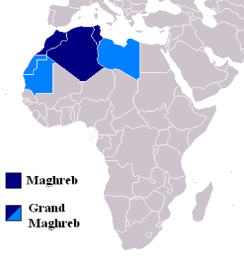
Maghreb
BROADLY DEFINED, the Maghreb is the triangular region of northwest Africa bounded by the ATLAS MOUNTAIN ranges, the ATLANTIC OCEAN from the border of western SAHARA to the Strait of Gibraltar, and the MEDITERRANEAN SEA from the Strait of Gibraltar to the northeast of LIBYA. Politically, the Maghreb includes the countries of MOROCCO, ALGERIA, TUNISIA and sometimes LIBYA. In the Middle Ages, Moorish SPAIN was included in the Maghreb. The Maghreb (maghrib) is Arabic for “the west.” The original Arabic name for the northwestern end of the African continent was Maghreb-el-Aqsa, “the land farthest west,” or “the place where the sun sets.”
The Maghreb is watered by westerly winds from the Atlantic Ocean. Ninety-five percent of the people of the Maghreb countries live between the Atlantic or Mediterranean coasts and the Atlas Mountains.
In the Moroccan part of the Maghreb, the Mediterranean coast is rugged with cliffs and coves. The Rif Mountains rise sharply from the Mediterranean to a height of 7,218 ft (2200 m). The Taza Gap runs east and west between the Rif Mountains and the Middle Atlas ranges to link Algeria with Morocco. Southeast from the Strait of Gibraltar are the Middle Atlas (Moyen Atlas) Mountains. Much of the area is high, partially forested plateaus. Farther south the High Atlas (Haut Atlas) Mountains reach to some of the highest peaks in Africa. Winter snows frequently cover the 400-plus mountaintops that exceed 9,850 ft (3,000 m). The highest peak is Mount Toubkal at 13,665 ft (4,165 m).
The Algerian part of the Maghreb has four eastwest zones. The coast stretches from Morocco 600 mi (970 km) to Tunisia. It extends inland from 50 to 120 mi (80 to 190 km). The coastal zone is a lowland strip dotted with mountains. The region is fertile and called the “Tell” in Arabic. The zone of the Tell Atlas Mountains (highest point about 7,570 ft or 2,310 m) is south of the coastal zone. South of the Tell, is a semiarid region of plateaus (average elevation is about 3,500 ft or 1,070 m) containing a number of shallow salt lakes (chotts). These wet-season lakes dry into salt pans during the dry season. A fourth zone holds the semi-arid Saharan Atlas Mountains, a broken series of mountain ranges and massifs.
TUNISIAN MAGHREB
The Tunisian area of the Maghreb contains two branches of the Atlas Mountains that extend eastward across the country from Algeria. Along the coast is a fertile plain. The northern range lies inland a short distance and is called the Atlas Mountains. Most of the mountains are low with peaks under 2,000 ft (610 m) in all but a few locations. The Tabassah Mountains form the southern Atlas branch of the Tunisian Maghreb. The highest is Mount Shanabi at 5,066 ft (1,544 m). The area includes the Grand Dorsal Range and the two-mile-wide Kasserine Pass. South of the Tabassah range the elevation descends across a plateau with salt lakes and date palm oases to the SAHARA DESERT.
The northwestern plain of Libya and the northeastern highland, an extension of the Atlas ranges, across the Gulf of Sidra are sometimes included in the Maghreb, for reasons of culture, if no other.