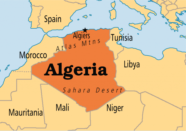
Algeria
Area 919,595 square mi (2,381,740 square km)
Population 39.93 million (2014)
Capital Algiers
Highest Point 9,852 ft (3,003 m)
Lowest Point -131 ft (-40 m)
GDP $214.1 billion (2014)
Primary Natural Resources petroleum and natural gas, mining.
WITH MORE THAN 80 percent of its land covered by the SAHARA DESERT in northern Africa, Algeria is a country with a history of trade, faith, and conflict. Bordered to the north by the MEDITERRANEAN SEA, Algeria lies between MOROCCO to the west and TUNISIA to the east. Occupying a geographic area of 919,595 square mi (2,381,740 square km), Algeria is the second-largest country in Africa, after SUDAN.

Dominated by the Sahara, Algeria is mostly high plateau with some mountains and a narrow coastal plain along the Mediterranean that has played a major role in the region's history. Strategic Roman outposts dotted Algeria's coast until Emperor Trajan (19–117 C.E.) spread his legions building distant desert cities like Thamugadi (Timgad) and Cuicul (Djemila); these imposing ruins still stand amid sand dunes and oil rigs. However, commanding these Roman settlements was not easy: Native Berber resistance to their presence was constant.
Algeria's Roman cities not only secured Roman involvement in the regional political theater, but also produced some of the Mediterranean's most distinguished personalities, including Saint Augustine of Hippo (354–430), one of Christianity's most notable theologians. Later besieged by Vandals in 429, followed by Byzantine troops 100 years later, Algeria has been a battlefield for citizenry against intruders for more than 2,000 years.
POPULATION GEOGRAPHY
Algeria's earliest inhabitants were Berbers who remained in the mountainous regions through Roman, Vandal, and Byzantine raids and colonization. Even during Arab expansion and the spread of Islam during the 7th century, the Berbers managed to stay distant, preserving much of their culture, and to this day they represent 30 percent of Algeria's population and a growing voice throughout the country. After Arab, Ottoman Turk, and Spanish influence, the French conquered Algeria in 1830. This protectorate of France endured cultural concession, oppression and compromise until the struggle for independence began in 1954. Fomented by the National Liberation Front (FLN), Algeria gained its political freedom eight long years later in 1962.
Since the late 1980s, Algerian politics have been managed by a discomforting antagonism between military and Islamic militants. In 1992, a victory by the Islamist Party was rescinded, setting off bloodshed that killed thousands of citizens. Only after national amnesty was declared were the weapons laid down on both sides.
After political instability and the natural death of President Boumediene in 1980, his closest friend and minister of foreign affairs, Abedlaziz Bouteflika, was forced into exile, only to return eight years later to work with the FLN Congress. In 1999, he was elected president and reelected in 2004. In 2002, after months of unrest among the Berber communities, the government recognized Berber as an official language, shaping a new focus on its unique culture and history.
Though the country is nearly 10 times the size of CALIFORNIA, Algeria's narrow Mediterranean coast is today home to most of the activity: cities, farms, ports, and highways. With a lucrative export trade overshadowing its low import levels, Algeria's industrial sector has been strong since oil was discovered in 1956. Algeria's extensive supplies now rank worldwide as fifth in gas reserves and 14th in oil, which have dramatically increased the gross domestic product. Oil and gas wells are primarily located inland, with an extensive pipeline network feeding the ports of Arzew and Skikda. Petroleum, petrochemicals, and natural gas are Algeria's largest exports.