Functions and Purposes
Maps, charts, plans, diagrams, and tables served a variety of functions and purposes in Islamic societies although the bulk seems to have spent their life in manuscripts, that is, in the spheres of educated readers. The earliest usage of maps seems to have happened when the armies of the newly converted Arab tribes invaded regions of Iran and Central Asia. The governor of the eastern parts of the Umayyad Empire, al Hajjaj b. Yusuf (d. 95h/714), is said to have ordered a map of Daylam, a mountainous region south of the Caspian Sea, before attacking it in c. 83 h/702. Five years later, when planning to lay siege at Bukhara, he ordered a plan of the city. Plans or sketches are also reported for planning in 141 h/758 the new capital Baghdad of the Abbasid caliphate and possibly for waterworks in the swamps near Basra made for the second Abbasid caliph al Mansur (r. 136–58 h/754–75). The next time that sources report of maps, sketches, or plans for military purposes occurs in the Ottoman Empire. Laying siege to cities and fortresses such as Constantinople, Szigetvar, Vienna, Baghdad, or the fortresses of the Order of St. John at Rhodes and Malta included the drawing of sketches and plans, while the actual warfare made use of compasses for tunneling the walls. It is only after the treaty of Karlowitz in 1699, that maps became an important tool for the Ottoman army for settling boundary disputes and negotiations over lost territories.
Tax collection and market regulation, on the other hand, were subjects that apparently rarely worked with maps, and the manuals written about these themes were seldom illustrated with more than the simplest diagrams. This is, according to Ahmet T. Karamustafa, even true for the Islamic society with the broadest use for maps and the widest array of types of maps – the Ottoman Empire. Different bodies of the Ottoman state used maps and plans that visualized waterways and channels, architecture, and navigation in the Mediterranean and the Black Sea.
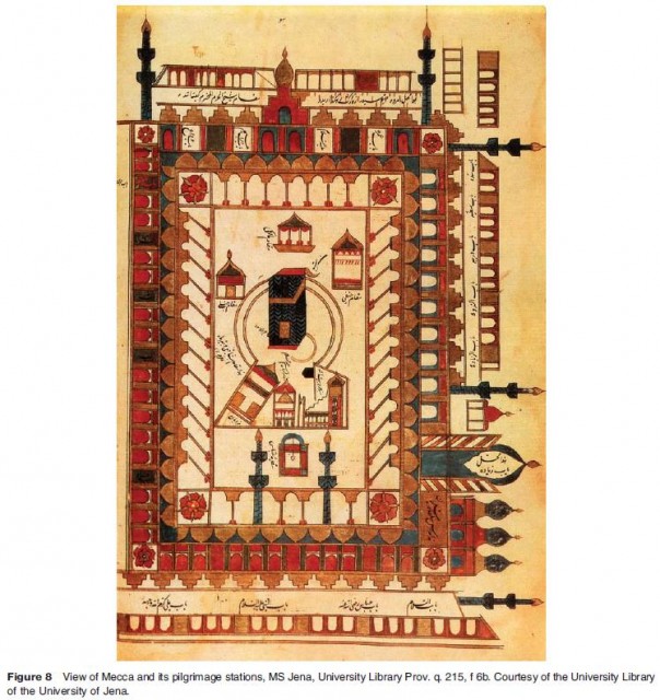
A central function of maps in Islamic societies was to indicate religious beliefs, support the believer in carrying out her or his religious duties, and help her or him remember the visits to the Holy shrines. A further religious theme illuminated by maps relates to the Prophet's mi'raj (ascent to the heavens). Maps functioned as instruments, tools, and pictorial narratives. They were turned into souvenirs and certificates (Figure 8).

Maps also served as objects of art and diplomacy. Fatimid world and regional maps were produced on costly silks embroidered with gold and colored silk threads. Consequently, they were stored with other valuables in the princely treasury rooms. The anonymous author of the Kitab al Hadaya wa'l Tuh.
af (Book of Gifts and Rarities) when describing the treasures stored by the Fatimid rulers exclaimed that among them several hundreds, close to a thousand silk drapes were found that represented kingdoms with their kings. He marveled at the precious material used for this display of royal splendor and possession and emphasized that these drapes showed a portrait of every king, his name, the span of his reign, and an account of his life. At least four more courts are known where maps were either painted on silk or engraved on silver plates – the court of the Khwarazmshah Sultan 'Ala' al Din Muhammad (r. 596–617 h/1199–1220) in Khiva, the court of the Ilkhanid ruler Ghazan Mahmud (r. 694–703 h/ 1295–1304) in Tabriz, the Norman court of Roger II (d. 1154) in Palermo, and the Ottoman court in Istanbul (857–1341 h/1453–1922). Except for Ottoman maps on silk, none of these maps are extant.
In various contexts, maps were treated like miniature paintings. Outstanding examples are the world map for Iskandar Sultan mentioned above, maps in a manuscript of the Beyan i Menazil i Sefer i 'Irak. eyn i Sultan Suleyman Han (Explanation of the Stops in Sultan Su?leyman Khan's Travel to the Two Iraqs) (944 h/1537–38) by Matrakc al Nasuh (d. 971 h/1564) commemorating Sultan Suleyman's (r. 926–74 h/1520–66) successful military campaign of 941 h/1534–35 against his Safavid neighbor Shah Tahmasb (r. 930–84 r/1524–76), and maps in eighteenth century manuscripts of Hajj? Khalfa's Cihannuma (version II).
A fourth function of maps was their capacity to memorize historical events and portray princely power and splendor. The most splendid examples of maps as constructs of historical memory are found in books describing and eternalizing the feats of the Ottoman sultans. Many of the views of cities and ports found in Ottoman histories since the early sixteenth century celebrate either their conquest by an Ottoman sultan or an attack by a fleet in Ottoman service. According to J. M. Rogers they were also meant to visualize ''the pomp and circumstance of the Ottoman court''. The composition of the views usually includes a representation of an abstract landscape – some mountains, some flowers, some herbs, occasionally also trees and animals. This theme of the landscape, its elements, and its colors is borrowed from miniature painting. The major difference between the maps and the miniatures is the complete lack of human beings in al most all maps of this genre.
A different, but equally splendid construction of imperial allegory can be found in miniatures produced for the Mughal rulers Jahang?r (r. 1014–37 h/1605–1628) and Shah Jahan (r. 1037–1068 h/1628–1658). Both rulers were keen to express their imperial claims by relying symbolically on the image of a globe with or without depictions of lands and seas. A series of images painted by Muslim and Hindu court painters between 1614 and 1658 stress the legitimacy of the ruler as a dutiful son, just defender of the interests of his subjects, and pious follower of the saints. Jahangir also used the globe for depicting his relationship to his most powerful Muslim neighbor outside of India, the Safavid Shah 'Abbas I (r. 986–1038 h/1587–1628). The portrait, called Jahang?r's Dream, shows Jahang?r as the superior and benign ruler who is connected by friendship with his smaller neighbor. Both stand on a world map that reflects knowledge of Western cartographic developments. Two animals rest at the feet of the two rulers, a lion and a lamb. The juxtaposition of lion and lamb symbolized the peaceful coexistence of natural enemies, of irreconcilable contradictions, hence the highest good a just ruler could achieve. The symbolic globe also figures in other portraits of Jahang?r, which describe his successful squelching of Khurram's rebellion, the later Shah Jahan, and his desire to destroy his political and military rival Malik 'Ambar, minister to the rulers of Ahmadnagar from 1596 to 1626. The minister valiantly opposed Mughal imperial ambitions in the Deccan and pursued a policy of steady recovery of territory conquered by Shah Akbar late in the sixteenth century. It was only 'Ambar's death in 1626 that opened the Deccan to Mughal invasion. The miniature of Jahang?r shooting at a beheaded and speared Malik Ambar while standing on a complex cosmological allegory composed of a terrestrial globe seated both on an elephant and a huge whale surrounded by a wealth of other symbolic elements expresses the magnitude of emotions roused in Jahang?r by the obstacle the Deccani minister of Ethiopian origin posed to fulfilling his im perial dream.
Most Islamic maps before the eighteenth century ignore political space in favor of cultural space. Elements that may signal political entities such as boundaries, emblems, names of dynasties, flags, or monuments rarely occur at all on Islamic maps before 1700. Maps of the so called Balkh? school indicate boundaries (hudud) explicitly, but they are not boundaries separating different states or kingdoms, but boundaries dividing the Islamic world into administrative subunits. In contrast to geographical writings, which even stressed the linkage between geography and history, maps produced in Islamic societies before the sixteenth century did not express this disciplinary neighborhood.
A similar reluctance to deal with the political composition of the world can be seen in maps illustrating the manuscripts of Hajj? Khalfa and Abu Bakr al Dimashq? (d. 1102 h/1691). In the autograph of the translation of the Atlas Minor, Hajj? Khalfa and his French partner Mehmet Ikhlas. ? followed closely the views about the political division of Europe and Asia as propagated by the Dutch cartographers Gerard Mercator and Henricus Hondius. In the autograph of Hajj? Khalfa's own geographical work for which he had engaged in the project of translation, the Cihannu?ma (version II), the Ottoman Empire is not mapped at all and the Safavid Empire has disintegrated into a series of maps reflecting views of Iranian provinces held in pre Safavid geographical literature. The fine copy of Abu Bakr al Dimashq?'s translation of the Atlas Major does not contain any map of the Ottoman or the Safavid Empires. Later paraphrases of the work map the two Muslim neighbor states as found in Western atlases, that is, the Ottoman Empire is clipped to Anatolia and the Safavid Empire has borders that fit more the situation of the early nineteenth than that of the late seventeenth or early eighteenth centuries when these maps were painted in Istanbul. Possibly the first Ottoman map that names Anatolia and even parts of Iran Memleket e devlet e 'aliye (Kingdom of the Supreme Dynasty), but continues to disregard the matter of precise boundaries of the empire in contrast to other states in Europe, is a silk map painted in Istanbul in 1182 h/1768. This map too follows without further reflection the structuring of the political space as seen in Catholic and Protestant Europe. A rupture with this disrespect for the political status and extension of the Ottoman state in Ottoman mapmaking occurred only in the nineteenth-century, when the modernized Ottoman army and its Western advisors took a fresh interest due to military and economic reasons in mapping the Ottoman territories.
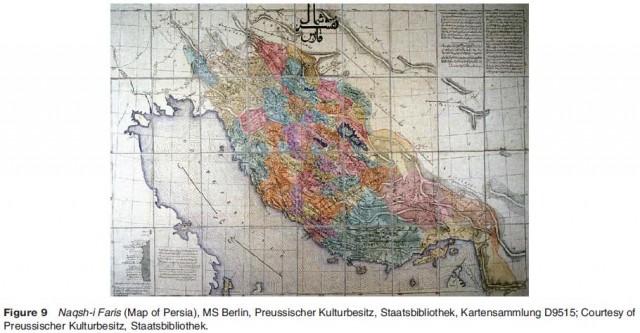
Maps of nineteenth-century Qajar Iran likewise do not show any explicit interest in mapping the political space of the country. Their authors mostly focused on mapping particular provinces and their physical and cultural properties. Qajar maps show clearly that by now mapmaking in Iran followed the map culture of Europe. In the first half of the nineteenth-century, British and Russian officers toured the country for mapping several of its provinces, mountains, and shores, partly on order of the Qajar court. In the second half of the nineteenth-century, Iranian mapmakers who were trained in modern mathematical and cartographic methods and concepts at the Dar al funun in Tehran started to work. The Dar al funun was a new type of school for higher education founded in 1851 by M?rza Taq? Khan Am?r i Nizam (1186 – assassinated in 1231 h sh/1807 – assassinated in 1852), a diplomat and highly disputed prime minister of the Qajar ruler Nasir al D?n Shah (r. 1227–75 h sh/1848– 96). The new school was part of efforts to reform the Qajar army. European teachers taught new military methods, theories, technologies, sciences including geography and cartography, and languages. The major cartographic works undertaken by Austrian professors and Iranian students and later professors of the Dar al funun were explorations, triangulations, descriptions, and drawings of boundaries between Iran, the Ottoman Empire, Central Asia, Afghanistan, and Northwest India (today Pakistan) and various kinds of mapping enterprises about Tehran and the settlements in its immediate environment. A number of the engineers involved in these different projects studied for some time in France or England and worked for different departments of the government and the army. In addition to mapmaking, they wrote books about geography and mathematics (Figure 9).
