Ice ages
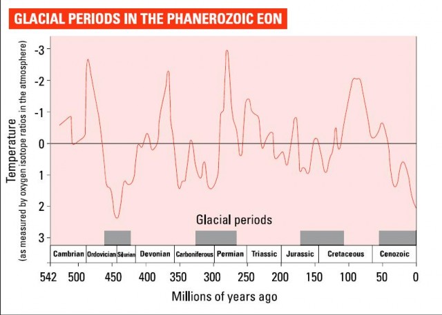
Snowball Earth may be the only time the Earth has completely frozen over. However, there have been periods of more or less severe glaciation throughout the Earths history. There were major glaciations about 3 billion years ago (the Archaean in geological time), about 2.4 billion years ago (the Proterozoic), and about 300 million years ago (the Permian and Carboniferous), as well as more recently.
Ice signs
Evidence for ice ages comes by the same route as the rest of our knowledge of the Earth – our awareness that the present is the key to the past. Like much else in the frozen world, the story starts in Switzerland. The key character is Louis Agassiz, who was born there in 1807 but died in the US in 1873. He was the first person to realize that the valleys of the Alps near his home had been formed by ice during a period when far more of the Earth was glaciated than we see today. The evidence he saw is replicated from California to Wales – and indeed equatorial Africa.

What he saw first were distinct u-shaped valleys, normally containing a river that is too undersized to have produced it by erosion. Such rivers are known cruelly as misfits and the u-shaped valleys that contain them have been cut by glaciers, not rivers. Agassiz (who became a well-known scientist in Europe betore being tempted away to the US and becoming a professor at Harvard, starting another trend that still continues) realized that the shape of the glaciers still found at high altitudes in the Alps matched the outline of the valleys thousands of metres lower down. This led him to suggest that they must have formed during an era when glaciation was far more common. He coined the term hiszeit in German to describe it. It is now in universal use in English as ice age.
Distinctive u-shaped valleys and size-challenged rivers are only some of the signs of past glaciation which Agassiz recognized. Rocks that have been shaped and polished by a passing glacier are called roches nioutonees, sheep rocks, because of their general appearance from far off. Look at them close up and something even more interesting becomes apparent. The uphill side is smooth where the ice has passed over it, but the downhill bit is rough where bits have been pulled off it.
Once-glaciated areas also have interesting sights to otter on a bigger scale. Sometimes they exhibit whole rock walls polished to a shine by ice.
But perhaps the most striking glacial feature is the cwm, a Welsh word now in use from Everest to the Andes for the half-cup shape bitten out of a mountain when a glacier forms.
A cwm is a deep mountain bowl formed by the ever-deepening snow and ice that form during an ice age. Over time, the ice turns from a snowfield to a glacier and sets off downhill, gouging out the rock below to form the cwm. Because the glacier tends to get started in an area where snow can survive the summer, they are often on north-facing slopes in the northern hemisphere and south-facing ones in the south, away from direct sunlight. Some such as those on Everest still contain glaciers.
Others have lost the glacier that formed there during a previous ice age but still form impressive gouges in big mountains. Their rear slopes are often steep and are a favourite haunt of rock climbers. Once a glacier gets going it does far more than polish stone. A typical glacier carries rock and other material by the millions of tonnes. Rocks dumped far from where they outcrop naturally are known in the trade as erra tics. Some are found hundreds of kilometres from home, and can be used to trace the routes which glaciers have taken. When a glacier melts, the leftovers are prodigious. Most common are a variety of moraines. These piles of glacial rock and gravel can be left at the end of a glacier (terminal moraine), at its edge (lateral moraine) or even its centre (medial moraine), when glaciers merge and two lateral moraines meet. Other landscapes distinctive of glaciation are drunilins – heaps of material like ancient burial mounds, laid down by ice and then shaped so that their long axis lies parallel to the glaciers line of march. And look out for eskers. They are long ridges of material laid down by retreating glaciers and are favoured footways in once-glacial regions.
At the edge of a glaciated area, vast amounts of gravel can be laid down, the product of bigger rocks being ground away. These are often quarried heavily for construction. In addition, large areas of once-glaciated land are covered in boulder clay. This is a highly distinctive soil made up of clay with large lumps of rock embedded in it and transported long distances by ice. So all in all, a glacial landscape is easy to read and full of interest.

It is more difficult to identity ice ages further back in history. However, amid ancient rocks, it is possible to find tillites. A soil such as boulder clay that has been laid down directly by a glacier is called a till, and tillites are tills that have been turned over time from soil-like deposits to solid rock. Rocks of the same age also exhibit scrapes from passing glaciers. Geologist Doug McDougall points out that it is by no means simple to identify a full-scale ancient ice age. Several symptoms such as tillites or glacier scrapes must be found in contemporaneous deposits from widely separated parts of the world. It must also be shown that ice was present at low levels as well as in high mountains. A period when ice was only around far above sea level is not an ice age.
Our own icy epoch
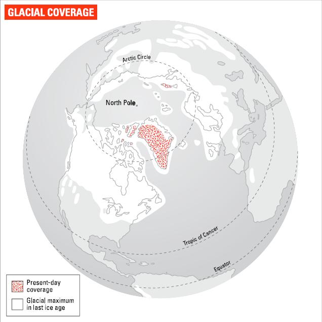
Even very ancient ice ages have now been mapped in detail. But most of our knowledge is of the more recent ice ages. The Pleistocene era, which lasted from 1.8 million years ago to about 10,000 years ago, when the Holocene era in which we are living began, was characterized by especially heavy glaciation.
There are a range of theories about why. They include fluctuations in the Earths orbit and its orientation in space as well as the growth of the Himalayas and perhaps increased atmospheric dust caused by volcanoes. Current theory puts changes in the Earths orbit via the Milankovich cycles in the driving seat.
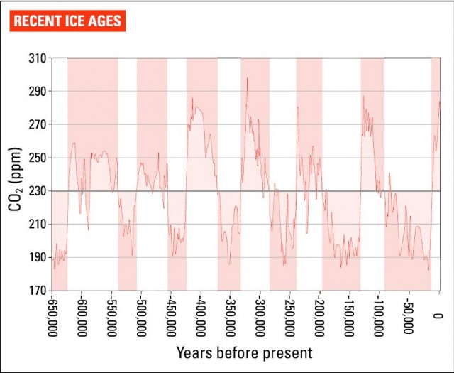
There seem to have been about 22 major ice ages during this period. The graph below shows the seven most recent, which took place in the last 650,000 years. It plots levels of atmospheric C02, which can be used as a surrogate for average temperature. As it shows, these ice ages have a roughly 100,000-year cycle, with most of that period icy in comparison to today and less than 20,000 years warm. Data provided by ice cores from the Antarctic and Greenland for the past few hundred thousand years, and from deep-sea sediment cores from earlier times, means that our knowledge of these climate changes is now very well established. However, exactly which of the low points count as ice ages is to some extent a matter of judgement, especially as some of the low points in more recent times are actually higher than some of the peaks earlier on.
The last ice age ended about 10,000 years ago. The warmer period since then is known as the Holocene. All our history and most of our archaeology are to be found in this period. Look out of the window and the Holocene is what you see. Alone among the portions of the geological column, it is still growing. Come back in 100 years and it will be about 1 percent longer.

Because people live for perhaps a hundred years if they are lucky, we think that the era we live in is normal. But it is the temperatures we experience today that are unusual. For most of the last million years, average conditions have been far colder than our idea of normality. And the most recent two ice ages, when sea level was about 120m lower and temperatures 5-10°C lower than today, were also the deepest on record.
However, as the graph shows, the current warm spell is nothing special. And on past form, you might think the line is due to head south again relatively soon. That is why geologists call it an interglacial – a period between ice ages – and speculate that we may be nearer in time to the next ice age than to the last one.
Even if a full-blown ice age does not happen soon, the temperature might not remain at its current balmy heights. During the most recent ice age there were two cold snaps, beginning about 14,000 and 12,800 years ago, now called the Older and Younger Dryas. They are named after the Dryas flower – still found today in tundra ecology, but far more wide- spread during these two periods. The Younger Dryas, about which we have more detailed information, lasted about 1200 years, and began and ended very suddenly. Seen alongside everything we know about the Little Ice Age, a cooler spell during the current warm period, it suggests that sudden, briet cold snaps may be more common than had been thought.