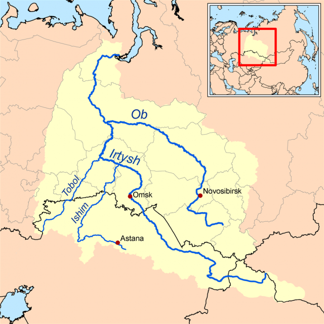
Ob-Irtysh River
THE OB AND THE IRTYSH rivers together form one of the largest river BASINs in the world, but also drain an area among the least populated and least known to outsiders. The rivers flow from the isolated mountain ranges of Central Asia (the ALTAI and Sayan ranges) across the sparsely populated Western Siberian Lowland to the Kara Sea, a subsidiary of the ARCTIC OCEAN. Population density for the basin as a whole is only nine persons per square km, but there are several large cities clustered around the mineral wealth of the river's southern watershed: Omsk on the Irtysh and Novosibirsk on the Ob are the largest cities in SIBERIA, along with Chelyabinsk, located on a tributary in the western part of the Ob-Irtysh Basin, in the URAL MOUNTAINS, which form the basin's western boundary. The basin covers 1,159,274 square mi (2,972,497 square km)— roughly the same as the MISSISSIPPI basin—and lies mostly within RUSSIA, though the southernmost courses of the Irtysh flow through northern KAZAKHSTAN and small corners of MONGOLIA and XINJIANG, CHINA. Altogether the rivers and their tributaries connect about 17,000 miles (27,400 km) of navigable waterways, though most of these are frozen for much of the year.

The Ob and Irtysh Rivers both have their headwaters in the highlands of the Altai Mountains, on the borders of Mongolia, where peaks reach heights of 13,200 ft (4,000 m) or more. This is one of the most remote spots on Earth, where four countries come together (Russia, Kazakhstan, Mongolia, and China), over 3,000 mi (4,800 km) from the sea. The two rivers start on different sides of this range, however, and do not meet up until both rivers have crossed most of the flat Siberian plains. The Irtysh is longer, but the Ob has more volume, and when they meet, at Khanty Mansiysk (a town named for the two dominant local indigenous groups), their course becomes sluggish and marshy. The far north of Russia is mostly flat and marshy, with little precipitation. Agriculture is severely limited by harsh climate and year-round permafrost. The Ob becomes divided into many ribbons, subject to enormous spring floods and dangerous ice flows during summer thaws. Here the river valley can at times reach 25 mi (40 km) wide. The Ob enters the sea through the 600 mi (375 km) Gulf of Ob, a forked indentation of the Kara Sea.
The region was sparsely populated by nomadic peoples (Mansy, Khanty, Nenets, and Samoyedic peoples) for centuries until Russians became attracted to the area for its “soft gold”: furs of numerous squirrels, otters, ermine, mink, and sable. Fortified wooden stockades were built at river junctions as trappers and merchants moved eastward, including such cities as Tobolsk (1587) on the Irtysh, and Salekhard (1595) on the Ob. This latter city is one of the furthest north in all of Russia, located close to where the Urals meet the Arctic at the Gulf of Ob and where the forests meet the Arctic tundra. Later cities were founded on the upper Ob (Narym and Tomsk) before the push for furs moved on eastward into Siberia. The large industrial cities of the south were built later, with the development of coal and iron ore industries, especially in the Kuznetsk Basin, and more recent pumping of oil near Surgut on the middle Ob. Because of the river's swampiness and lengthy periods of ice cover (generally October to May), it is not used much for navigation. There has been some harnessing of the great volumes of water flowing off of the Altai Mountains, notably at a hydropower station on the Irtysh in northeastern Kazakhstan, at Ust-Kamenogorsk, close to where the river (called the Ertix) flows out of Mongolia and into the large Zaysan lake. This region is one of Kazakhstan's most industrialized and holds a large portion of its population. The lower parts of the rivers are spawning grounds for sturgeon, salmon and whitefish, and the Ob estuary forms one of the largest fishing industries in the Russian Arctic.