Plate Tectonics
On the globes and maps we've seen since childhood, the outline of each continent is so unique that we would never mistake one continent for another. But why are no two continents even closely alike? The answer lies in the long formation history of the Earth's surface features, which is driven by the movement of lithospheric plates. The science of lithospheric plate motions is called plate tectonics.
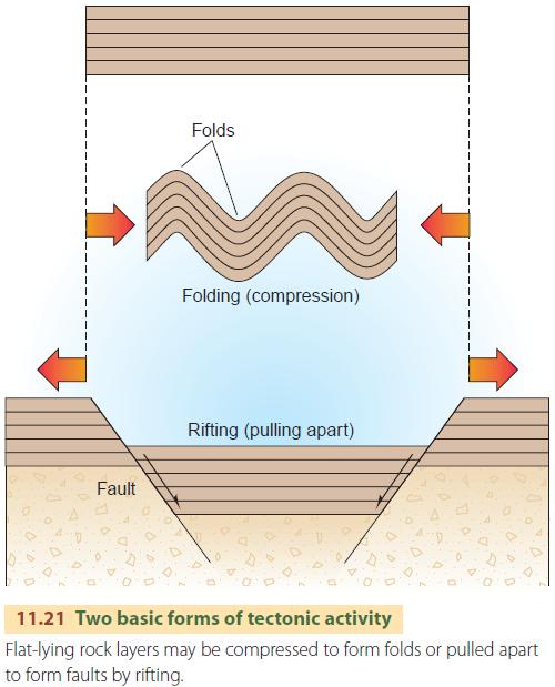
Prominent mountain masses and mountain chains (other than volcanic mountains) are created either by extensional tectonic activity or by compressional tectonic activity (Figure 11.21). Extensional tectonic activity occurs when oceanic plates are pulled apart or when a continental plate breaks up into fragments. As the crust thins, it is fractured and pushed upward, producing block mountains.
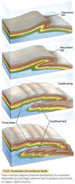
Compressional tectonic activity—squeezing together or crushing—acts at converging plate boundaries. The result is often an alpine mountain chain consisting of intensely deformed strata of marine origin. The strata are tightly compressed into wave-like structures called folds. Accompanying the folding is a form of faulting in which slices of rock move over the underlying rock on fault surfaces with gentle inclination angles (Figure 11.22).
These are called overthrust faults. The individual rock slices, called thrust sheets, are carried many tens of kilometers over the underlying rock. In the European Alps, thrust sheets of this kind were named nappes (from the French word meaning “cover sheet” or “tablecloth”).
PLATES AND BOUNDARIES
Figure 11.23 shows the major features of plate interactions. There are two types of lithosphere—oceanic and continental. Oceanic lithosphere is thinner and denser (about 50 km, or 30 mi thick), whereas continental lithosphere is thicker and lighter (about 150 km, or 95 mi thick). Think of these plates as “floating” on the plastic asthenosphere, similar to blocks of wood floating in water, where a thicker block rides higher above the water surface than a thinner block. For the same reason, the thicker continental surfaces rise higher above the ocean floors.
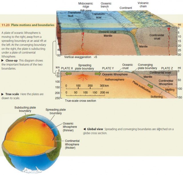
In the figure, plates X and Y are pulling apart along their common boundary, which lies along the axis of a midoceanic ridge. This pulling apart creates a gap in the crust that is filled by magma rising from the mantle beneath. The magma appears as basaltic lava in the floor of the rift and quickly congeals. At greater depth under the rift, magma solidifies into gabbro, an intrusive rock of the same composition as basalt. Together, the basalt and gabbro continually form new oceanic crust. This type of boundary between plates is termed a spreading boundary.
At the right, the oceanic lithosphere of plate Y is moving toward the continental lithosphere of plate Z. Where these two plates collide, they form a converging boundary. Because the oceanic plate is comparatively thin and dense, in contrast to the thick, buoyant continental plate, the oceanic lithosphere bends down and plunges into the asthenosphere. The process in which one plate is carried beneath another is called subduction.
The leading edge of the descending plate is cooler and therefore denser than the surrounding hot, soft asthenosphere. As a result, the slab sinks under its own weight, once subduction has begun. However, as the slab descends, it is heated and softened. The under portion, which is mantle rock in composition, simply reverts to mantle rock.
The descending plate is covered by a thin upper layer of less dense mineral matter derived from oceanic and continental sediments. This material can melt and become magma.
The magma tends to rise because it is less dense than the surrounding material. The figure shows some magma pockets on the right, formed from the upper edge of the slab. They are pictured as rising like hot-air balloons through the overlying continental lithosphere. When they reach the Earth's surface, they form a chain of volcanoes lying about parallel with the deep oceanic trench that marks the line of descent of the oceanic plate.
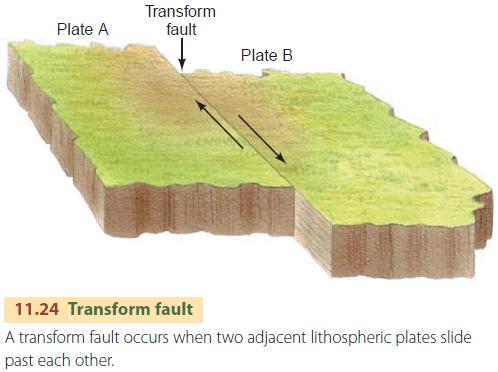
In addition to spreading and converging boundaries, there is also the transform boundary. Here, one lithospheric plate slides past the other without separating or converging. The two plates are in contact along a vertical fracture, called a transform fault (Figure 11.24).
THE GLOBAL SYSTEM OF LITHOSPHERIC PLATES
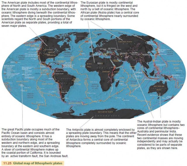
The Earth's surface is composed of six major lithospheric plates—Pacific, American, Eurasian, African, Austral-Indian, and Antarctic. There are also several lesser plates and subplates. Figure 11.25 shows the major plates and describes their motions.
CONTINENTAL RUPTURE AND NEW OCEAN BASINS
We have already noted that the Atlantic margins have no important tectonic activity, even though they mark the contact between oceanic lithosphere and continental lithosphere.
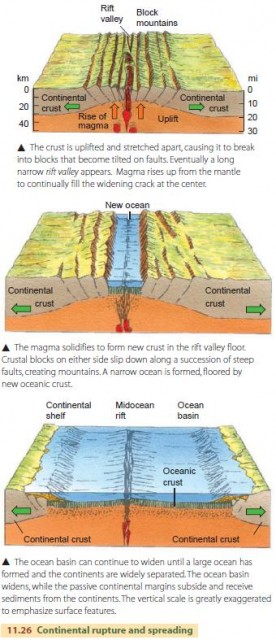
Passive margins such as these are created by a process called continental rupture (Figure 11.26). This occurs when tectonic forces uplift a plate of continental lithosphere and pull it apart. At first, a rift valley forms, and as the bottom of the rift valley sinks below sea level, sea water enters. Eventually, a wide ocean forms with an axial rift down its center.
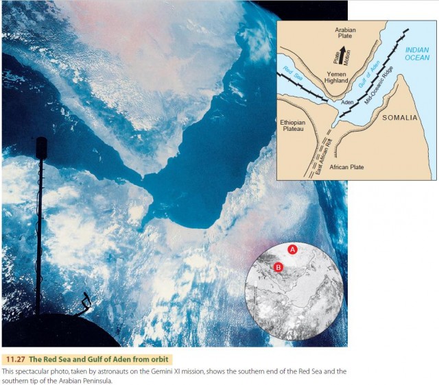
The Red Sea is a good example of a continental rupture in progress. Figure 11.27 shows an astronaut photo of the Red Sea where it joins the Gulf of Aden. As shown in the inset map, this is a triple junction of three spreading boundaries created by the motion of the Arabian plate pulling away from the African plate. It is easy to visualize how the two plates have split apart, allowing the ocean to enter.
ISLAND ARCS AND COLLISION OF OCEANIC LITHOSPHERE
When a continent ruptures to form an ocean basin with axial rift, the two new plates move apart and create a new ocean. But eventually the plate motions may reverse, and the ocean basin may start to close. For this to happen, a plate must fracture and produce a subduction boundary. If the fracture occurs at a passive continental margin, oceanic crust will be subducted below continental crust, as shown in Figure 11.23. But what happens if the fracture occurs in the middle of a plate of oceanic lithosphere? This situation is shown in Figure 11.28.
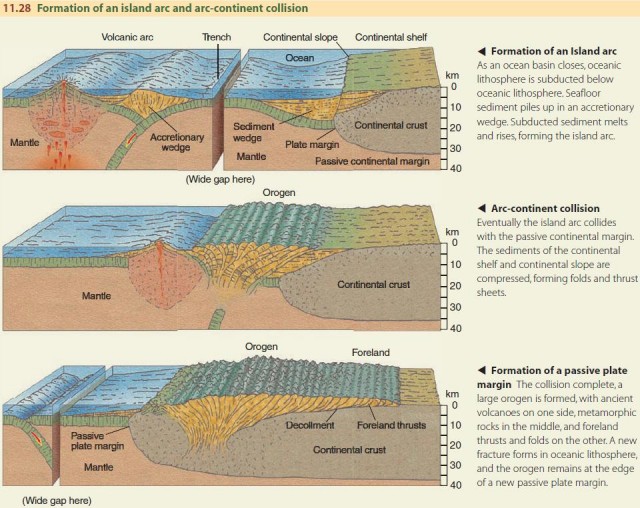
As the subducted oceanic lithosphere plunges downward, oceanic crust is carried into the mantle. Since it originally came from the mantle and is of the same composition, it simply melts and disappears into the mantle rock.
However, the descent of the plate also carries a thin layer of ocean-floor sediment into the mantle. The heat and pressure of the mantle melt this sediment, and because it is less dense than the mantle rock, it begins to rise. The result is the formation of an island arc—a chain of volcanoes paralleling the subduction trench. We saw this process earlier in the formation of a volcanic arc on land, near the margin of a continent, in the collision of lithospheric crust with oceanic crust in Figure 11.23.
In the early stages, the island arc is an isolated chain of island volcanoes. The Aleutian Islands are a good example. They stretch from Alaska to Russia and are seen along the northernmost oceanic trench in the left part of Figure 11.20.
As the process continues, seafloor sediment piles up in the trench, forming an accretionary wedge of sediments. Meanwhile, the continuing rise of magma fortifies the island arc from below, increasing the height and width of the volcanic mass.
ARC-CONTINENT COLLISION
If ocean-basin closing continues, the island arc eventually collides with a passive continental margin. Since the island arc is thick and buoyant, it is not subducted but pushed up against the continent. The layers of sediment that have accumulated on the continental shelf and continental slope are crushed and deformed.
The sediments are thrust far inland over the older continental rocks, creating nappes and foreland folds. We call this process “telescoping” because it's similar to the way that a folding telescope collapses from a long tube into a short cylinder. The mass of collided rocks is called an orogen, and the process of its formation is described as an orogeny. If collision continues, another fracture develops and a new subduction boundary is formed.
CONTINENT-CONTINENT COLLISION
Where the subduction boundary closing the ocean basin lies at the edge of a continent, continued closing results in a continent-continent collision (Figure 11.29). The collision permanently unites the two plates, so that there is no further tectonic activity along that collision zone. The collision zone is called a continental suture.
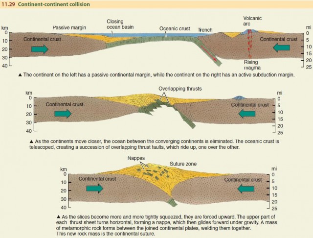
Continent-continent collisions occurred in the Cenozoic era along a great tectonic line that marks the southern boundary of the Eurasian plate. The line begins with the Atlas Mountains of North Africa and runs, with a few gaps, to the great Himalayan Range, where it is still active. Each segment of this collision zone represents the collision of a different northmoving plate against the single and relatively immobile Eurasian plate.
Continent-continent collisions have occurred many times since the late Precambrian time, including many with island arcs sandwiched between the colliding land masses. Geologists have identified several ancient sutures in the continental shields. One example is the Ural Mountains, which divide Europe from Asia and were formed near the end of the Paleozoic era. Others are the Appalachian Mountains of eastern North America and the Caledonian Mountains of Scotland, Norway, Svalbord, and eastern Greenland, which date from mid-Paleozoic time.
THE WILSON CYCLE AND SUPERCONTINENTS
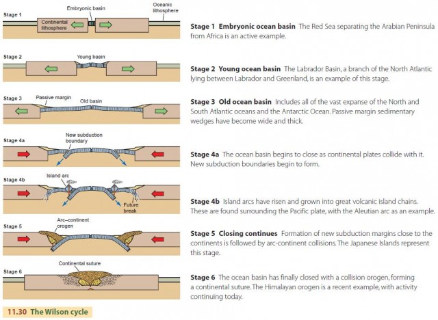
Geologic evidence has shown that ocean basins have opened and closed many times in the geologic past. The cycle of opening and closing is called the Wilson cycle, named for the Canadian geophysicist J. Tuzo Wilson (Figure 11.30).
The Wilson cycle begins with continental rupture and the formation of a wide ocean basin (stages 1–3). As the relative plate motions reverse, and the ocean basin begins to close, oceanic lithosphere fractures and new subduction boundaries are formed (stage 4a). Island arcs soon appear and continue to grow with time (stage 4b). Eventually, fractures occur at the continental margins, and the arcs collide with continents, producing arc-continent orogens (stage 5). In the final stage, the orogens collide, producing a continental suture (stage 6).
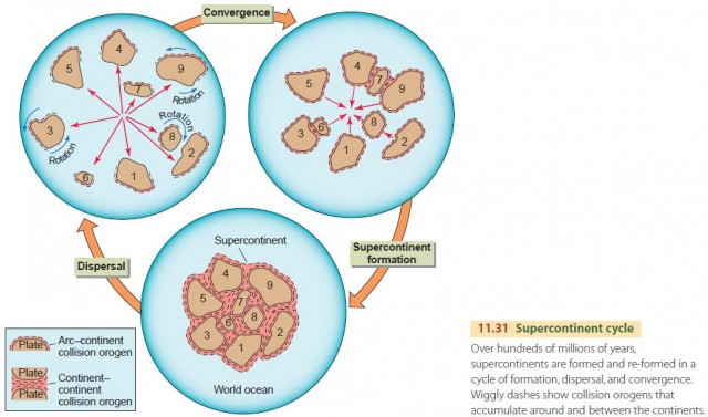
With the continents in motion, we might ask where they all go and when. There is strong evidence that all the continents were once joined in a single land mass that subsequently broke apart. Imagine that the world's ocean basins all close at once, following the Wilson cycle. The result would be a supercontinent containing most or all of the Earth's continental crust. Many lines of evidence show that such a supercontinent, now called Pangaea, came into existence about 200 million years ago. It was actually preceded by an earlier supercontinent, dubbed Rodinia, that was fully formed about 700 million years ago.
Figure 11.31 shows this supercontinent cycle, in which a supercontinent is formed, then split apart by lithospheric fractures and multiple plate motions. The continents then converge again with new orogens along their margins, forming a new supercontinent. There may have been as many as 6 to 10 such cycles in the Earth's ancient history. The hypothesis of a time cycle of supercontinents now holds its place as the basic theme of the geologic evolution of our planet.
THE POWER SOURCE FOR PLATE MOVEMENTS
Lithospheric plates are huge, so it must take enormous power to drive their motion. Where does this power come from? The power source lies in the heat released by radioactivity.
You may know from basic chemistry that some elements have unstable isotopes—forms that spontaneously emit energy or matter in the process of radioactive decay. The energy is absorbed by the surrounding matter and is called radiogenic heat. Most of the Earth's radiogenic heat is released in the rock beneath the continents, within the uppermost 100 km or so (about 60 mi). This heat keeps Earth layers below the crust close to the melting point, providing the power source for the formation of magma.
We don't know exactly how radiogenic heating produces plate motions. One theory is that plate motions are produced by convection currents in hot mantle rock. Since hotter rock is less dense than cooler rock, unequal heating could produce streams of upwelling mantle rock that rise steadily beneath spreading plate boundaries. Some geologists hypothesize that the rising mantle lifts the lithospheric plate up and the plate then fractures and moves horizontally away from the spreading axis under the influence of gravity. This is called gravity gliding. Another theory is that once the plate begins to descend, the descending part pulls the rest of the plate along because it is cooler, and therefore more dense, than the mantle rock. Explaining the mechanisms that drive plate motions is a future research goal of many geophysicists.
CONTINENTS OF THE PAST
Modern plate tectonic theory is only a half a century old. But as far back as the nineteenth century, German meteorologist and geophysicist, Alfred Wegener, suggested that our continents are fragments of a single supercontinent. As good navigational charts became available, geographers could see the close correspondence between the outlines of the eastern coast of South America and the western coastline of Africa. Wegener proposed the first full-scale scientific theory describing the breakup of a single supercontinent, which he named Pangaea, into multiple continents that moved apart in a process called continental drift (Figure 11.32). He suggested that Pangaea existed intact as early as about 300 million years ago, in the Carboniferous Period.
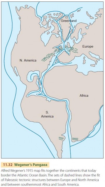
A storm of controversy followed Wegener's proposal, but he had some loyal supporters. He presented several lines of hard scientific evidence for Pangaea, including the distribution patterns of fossils and present-day plant and animal species. But his explanation of the physical process that separated the continents was weak, and geologists soon showed that it was wrong.
In 1930, Wegener died of cold and exhaustion while on an expedition to the Greenland ice sheet. But in the 1960s, his theory was revived. Seismologists showed that thick lithospheric plates are in motion. Within a few years, Wegener's scenario was validated, but only by applying a mechanism for the process—seafloor spreading produced by mantle convection currents—that was never dreamed of in his time.
The continents are moving today. Data from orbiting satellites shows that rates of separation or of convergence between two plates are on the order of 5 to 10 cm (about 2 to 4 in.) per year, or 50 to 100 km (about 30 to 60 mi) per million years. At that rate, global geography must have been very different in past geologic eras than it is today.
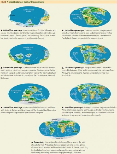
Figure 11.33 shows a reconstruction of continental motions of the last 600 million years or so. Before Pangaea, the supercontinent Rodinia, which was fully formed about 700 million years ago, broke apart and its fragments were carried away in different directions. While still in motion, the continents briefly assembled into the supercontinent Pannotia. Eventually, Pangaea was formed. It then broke apart, creating Laurasia in the northern hemisphere, which contained the regions that are now North America and western Eurasia, and Gondwanaland south of the Equator, which contained the regions that are now South America, Africa, Antarctica, Australia, New Zealand, Madagascar, and peninsular India. Some interesting evidence suggests that there may have been yet another supercontinent before Rodinia.
