Climate and Altitude Gradients
CLIMATE GRADIENTS AND BIOME TYPES
As we have seen, biomes and formation classes change along with climate. Figure 9.34 shows three continental transects that illustrate this principle.
The upper transect stretches from the Equator to the Tropic of Cancer in Africa. Across this region, climate ranges through all four low-latitude climates: wet equatorial, monsoon and trade-wind coastal, wet-dry tropical , and dry tropical . Vegetation grades from equatorial rainforest, savanna woodland, and savanna grassland to tropical scrub and tropical desert. The middle transect is a composite from the Tropic of Cancer to the Arctic Circle in Africa and Eurasia.
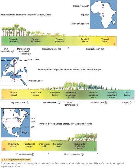
Climates include many of the mid- and high-latitude types: dry subtropical, Mediterranean, moist continental , boreal forest, and tundra. The vegetation cover grades from tropical desert through subtropical steppe to sclerophyll forest in the Mediterranean. Farther north is the midlatitude deciduous forest in the region of moist continental climate, which grades into boreal needleleaf forest, subarctic woodland, and finally tundra.
The lower transect ranges across the United States, from Nevada to Ohio. On this transect, the climate begins as dry midlatitude. Precipitation gradually increases eastward, reaching moist continental near the Mississippi River. The vegetation changes from midlatitude desert and steppe to short-grass prairie, tallgrass prairie, and midlatitude deciduous forest.
ALTITUDE GRADIENTS
While climate varies with latitude and longitude, it also varies with elevation. At higher elevations, temperatures are cooler and precipitation is usually greater. This can produce a zonation of ecosystems with elevation that resembles a poleward transect.
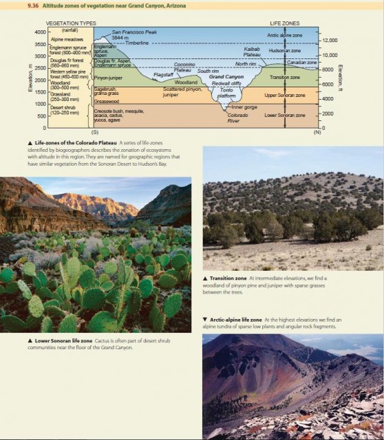
The vegetation zones of the Colorado Plateau region in northern Arizona and adjacent states provide a striking example of altitude zonation. Figure 9.36 shows a cross section of the land surface in this region along with photos of typical vegetation types you might see at different elevations. Rainfall ranges from about 120 mm to 900 mm as elevation increases from about 700 m (about 2300 ft) at the bottom of the Grand Canyon to 3844 m (12,608 ft) at the top of San Francisco Peak. Temperature also decreases substantially with elevation.
Noting the variation in vegetation cover with altitude, biogeographers working in this region developed a series of life-zones to refer to these cover types. They relate the appearance of the vegetation cover to regions you might encounter on a transect from Mexico to the Arctic Ocean.