Weather: Canada
The worlds second-largest country, Canada has the worlds most extensive coastline, fronting the Atlantic, Pacific and Arctic Oceans. This provides plenty of raw material for a varied climate, much like that of the United States, but colder and drier on average. Storm systems often spin up along the nations southern tier (especially in Alberta) before diving south of the border toward the Great Lakes. Another big factor is Hudson's Bay, which cuts well into the eastern half of Canada. Frozen for roughly half of the year, the bay encourages polar cold to extend much further south than it otherwise would. Permafrost edges closer to the equator here than anywhere else in the world Only the maritime provinces of the far southeast benefit from the northerly extensions of the Atlantic's Gulf Stream current; further up Canada's east coast is the cold Labrador Current. Despite this icy picture, there are, in fact, many places and times where Canadians take their heavy coats off and visitors can comfortably marvel at the scenery. The western prairie states often thaw out in mid-winter; the marine cities of Vancouver and Halifax aren't much colder than Seattle or Boston, respectively; and most of the nation enjoys long, sunny, warm days in July. In fact, southern Ontario can be decidedly muggy at times.
Canada is one of the world's most sensitive barometers of climate change. The average temperature in recent years has sometimes run more than 1.5°C/2.7°F above the long-term national average, with the warming especially pronounced in winter. Erratic thaws have complicated life for those who depend on the yearly melting-and-freezing cycle, from indigenous people to polar bears.
Eastern Canada
Many visitors to Canada end up inside the broad southeastern belt that holds a majority of the nation's 30 million people, from southern Ontario across Quebec to the Maritime Provinces. This zone – tucked between the Great Lakes, the Gulf of St Lawrence and the Atlantic Ocean – has a four-season climate much like New England s. Cities well inland, such as Ottawa, struggle to get above freezing during the depths of winter, while the average January highs for the lakeside city of Toronto and the coastal city of Halifax are closer to 0°C/32°F. Along with coastal gales and bright, bitterly cold days, winter can bring a few rounds of freezing rain as well as snow. The cold hangs on well into spring, and fog often cloaks the maritime reaches, but summer and early autumn are quite pleasing. Lows typically stay above 10°C/50°F and highs approach 26°C/79°F, with conditions a touch warmer as you move in from the Atlantic. A few intense tornadoes have been known to strike southern Ontario, the so-called “banana belt” of Canada (although no actual bananas grow there).
Further east, the island of Newfoundland has a climate similar to Nova Scotia's, albeit cloudier and damper. Labrador is even colder in winter and tends to be chilly and cloudy in summer (the snow often doesn't melt until late May). On rare occasions, hurricanes that quickly curve up from the western Atlantic or the US East Coast can bring high wind and heavy rain across the Maritimes. Weather changes are frequent throughout the year across eastern Canada, and precipitation is remarkably well distributed. Across the populated areas, a typical month brings about 50-80mm/2-3in of moisture falling on about 10 to 15 days.
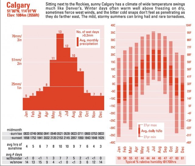
The Prairie Provinces
Canada's northernmost cities of consequence – Winnipeg, Saskatoon, Regina, Calgary and Edmonton – are spread out across the open lands that separate the Rocky Mountains from the forests and bogs around Hudson's Bay. Much like the steppes of Ukraine and southern Russia, this prairie has rich soil and very long, warm summer days well suited to growing grain; in fact, the eastern prairies can get somewhat muggy in mid-summer. There are just enough summer showers and thunderstorms to keep the land fertile (although they also bring an occasional tornado and, especially in Alberta, frequent rounds of hail). Prairie winters alternate between howling northerlies and mild, but ferocious, westerlies blowing off the Rockies. Blizzards are a very serious business – visibility can drop to near zero – but with moisture limited, the snowfalls are seldom as heavy as in the worst East Coast storms. Averaged across the year, this is the sunniest part of Canada.
British Columbia
Much like Oregon and Washington, British Columbia features a stark contrast between a wet, mild coastline and a drier basin-and-range climate further inland. Vancouver is only a couple of degrees cooler than Seattle, but lacking the shield of the Olympic Peninsula, it gets almost twice as much rain (not so much more often as more intensely). The west slopes of the coastal mountains and the higher peaks inland get huge amounts of wintertime snow and rain, but the east slopes are far drier. British Columbia feels the effects of both El Nifio (producing a tendency toward dryness) and La Nifia (higher odds of abnormally heavy rain and snow). Unusually mild winters and dry summers have boosted the risk of forest fire in recent years across
the interior.
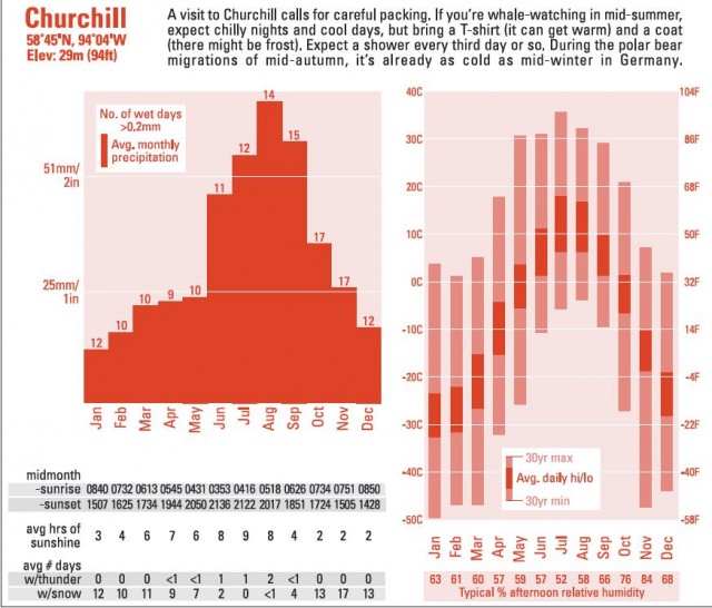
Northern Canada
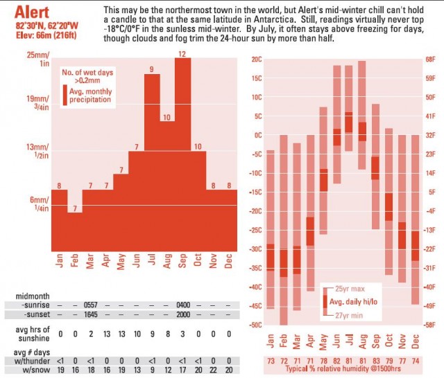
Northern Canadians deal with some of the most inhospitable weather of any populated place on the globe. In January the average temperature from Yukon to the coast of Hudson's Bay runs from -25°C/-13°F to -35°C/-31°F. However, conditions actually become comfortable in the near-continuous sunlight of summer. Interior sections climb above 16°C/60°F on most summer days, and highs above 35°C/95°F have occurred Near the Arctic Ocean, the barely-above-freezing water keeps the typical July day below 16°C/60°F, and clouds and fog are frequent. If that's too warm for you, head north across the hundreds of islands spread between Canada and Greenland. At latitude 82.5°N, you'll find Alert, the world's northernmost permanently inhabited settlement, where about 100 weather and climate researchers coexist with Arctic foxes and polar bears.