tornadoes
A TORNADO IS A RAPIDLY rotating column of air under a thundercloud. The term is believed to have come from the Spanish tronada, meaning thunderstorm. However, alternate etymologies have been traced from various Spanish and French words meaning “to turn.” Common names for a tornado include twister and funnel cloud. The biblical “whirlwind” was probably a tornado.
Wind speeds within a tornado can reach up to 300 mi per hour (480 km per hour). Tornadoes are classified on the Fujita scale, named for Japanese-born American meteorologist T. Theodore Fujita. The Fujita scale runs from F0, a relatively weak tornado that damages only lightly built structures, to F5, a powerful tornado capable of leveling a small town.
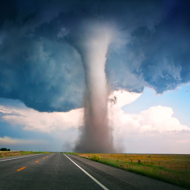
Tornadoes develop from supercell thunderstorms, which have a distinctive structure easily recognized by weather radars. Within the supercell storm, winds of different speed and direction create areas of wind shear that produce a rotating column of air known as the mesocyclone. This leads to the development of a wall cloud at the base of the supercell. The tornado proper descends from the wall cloud. Some very powerful tornadoes contain suction vortices, small sub-tornadoes that revolve around the funnel cloud's central axis and leave a distinctive spiral path in the debris field.
Almost all tornadoes in the Northern Hemisphere spin counterclockwise, a behavior believed to be an effect of the Earth's rotation. Occasionally a clockwise tornado is observed, but it is generally weak and almost always a “sister” to one spinning the usual way. A more dangerous tornado rarity is the “invisible” tornado, which lacks a visible funnel. The cloud of dust and debris rising from its base may be mistaken for a harmless dust devil. However, dust devils form primarily on hot, sunny days, so an apparent dust devil under a cloudy sky should be considered a probable tornado.
U.S. TORNADOES
The UNITED STATES has the highest incidence of tornadoes in the world. The convergence of several geographic features make the American heartland particularly susceptible to these powerful storms. North America's principal mountain ranges run from north to south, with a broad plain between them. The western range, the ROCKY MOUNTAINS, often guides cold Arctic air down onto the midwestern prairie, while the Gulf of Mexico to the south provides a northward flow of warm, moist air. When these air masses collide along weather fronts, they produce the supercell thunderstorms that spawn tornadoes.
A similar geological combination exists in BANGLADESH, with cold air from the HIMALAYAS colliding with warm, moist air from the BAY OF BENGAL across level lowlands. However, while American tornadoes are characterized by relatively low loss of life but enormous monetary losses, Bengali tornadoes often reap enormous numbers of fatalities while causing relatively little property damage. The difference is less meteorological than social and economic: while the American gets ample warning to take cover but must abandon substantial material wealth to the storm, the Bengali has little material wealth to lose but often has no access to any warning system.
America's tornado warning system did not come without significant resistance. For decades, forecasters were strictly forbidden to mention the word “tornado,” for fear that they would create a panic. Only after a tornado struck an air force base did that policy change. Two levels of alert were created. A tornado watch means that conditions are favorable for the development of tornado-spawning storms. Watches are laid out over large areas known as “watch boxes” in forecasters' jargon, and are often shown as large red rectangles or parallelograms on weather maps. A tornado warning is issued only when the characteristic “hook echo” of a mesocyclone has been detected by Doppler radar, or a spotter on the ground has sighted a funnel cloud.
There are several notable historical tornadoes. The Tri-State Tornado of March 18, 1925, set numerous records. Crossing from MISSOURI through southern ILLINOIS to INDIANA, it was so wide it did not show a funnel, just a wall of blackness. At 60 mi per hour (97 km per hour), it was the fastest-moving tornado, and its forward movement combined with its rotational speed to increase its destructive power. It remained on the ground for three and a half hours, leaving a path 219 mi (352 km) long and 695 deaths in its wake.
The greatest number of tornadoes spawned by a single weather system occurred during the Superoutbreak of April 3 and 4, 1974. After an extensive study of the damage, Professor Fujita drew a map showing all 148 tornadoes that struck on those two days. The most destructive of them struck Xenia, Ohio, leaving 34 dead and millions of dollars of damage.
Another notable tornado struck Plainfield, Illinois, in 1990. An anomalous tornado, it was not recognized until it was too late to warn the town, and the storm sirens sounded only after the funnel cloud had passed. Fujita came out of retirement to personally study the damage, and his discoveries about these microburst tornadoes led to improvements in tornado forecasting.