Air Masses
We know that the Earth's atmosphere is in constant motion, driven by the planet's rotation and its uneven heating by the Sun. The horizontal motion of the wind moves air from one place to another, allowing air to acquire characteristics of temperature and humidity in one region and then carry those characteristics into another region. In addition, as winds at the surface converge and diverge, they produce vertical motions that affect clouds and precipitation. When air is lifted, it is cooled, enabling clouds and precipitation to form. When air descends, it is warmed, inhibiting the formation of clouds and precipitation. In this way, the Earth's wind systems influence the weather we experience from day to day—the temperature and humidity of the air, cloudiness, and the amount of precipitation.
Some patterns of wind circulation occur commonly and so present recurring patterns of weather. For example, traveling low-pressure centers (cyclones) of converging, inspiraling air often bring warm, moist air in contact with cooler, drier air, and clouds and precipitation are typically the result. We recognize these recurring circulation patterns and their associated weather as weather systems.
In the midlatitudes, weather systems are often associated with the motion of air masses—large bodies of air with fairly uniform temperature and moisture characteristics. An air mass can be several thousand kilometers or miles across and can extend upward to the top of the troposphere. We characterize each air mass by its surface temperature, environmental lapse rate, and surface specific humidity. Air masses can be searing hot, icy cold, or any temperature in between.
Moisture content can also vary widely between different air masses.
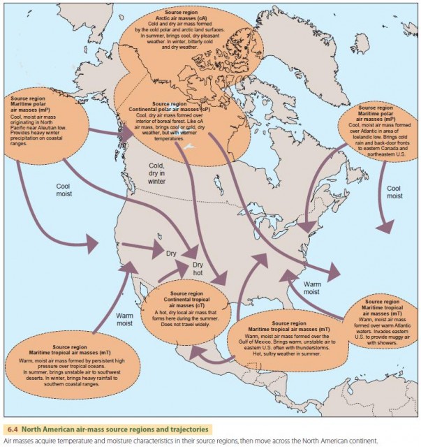
Air masses acquire their characteristics in source regions. In a source region, air moves slowly or not at all, which allows the air to acquire temperature and moisture characteristics from the region's land or ocean surface. For example, a warm, moist air mass develops over warm equatorial oceans.
In contrast, a hot, dry air mass forms over a large subtropical desert. Over cold, snow-covered land surfaces in the arctic zone in winter, a very cold air mass with very low water vapor content is found.
Pressure gradients and upper-level wind patterns drive air masses from one region to another. When an air mass moves to a new area, it can retain its initial temperature and moisture characteristics for weeks before it comes to fully reflect the new surrounding environment. This is one of the most important properties of air masses—they have the temperature and moisture characteristics of their original source regions, even as they move away from those regions.
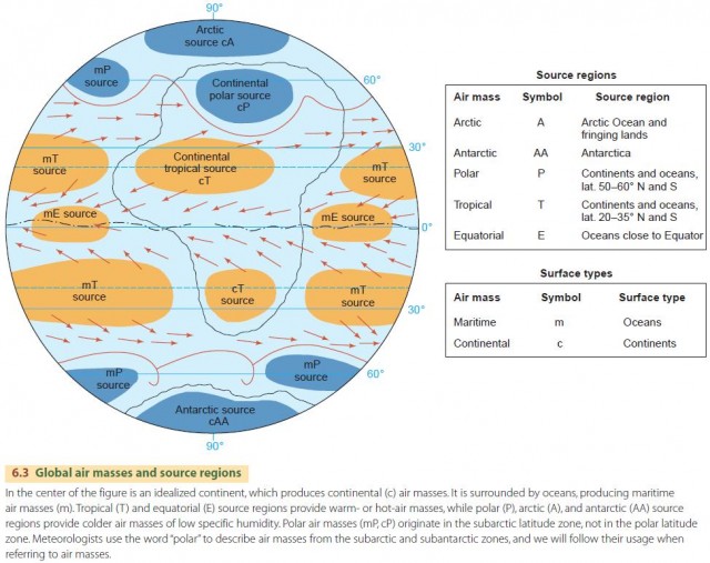
We classify air masses by the latitude zone (arctic, polar, tropical, equatorial) and surface type (maritime, continental) of their source regions. Combining these labels produces a list of six important types of air masses (Figure 6.3). Latitudinal position is important because it determines the surface temperature and the environmental temperature lapse rate of the air mass. For example, air-mass temperature can range from –46°C (–51°F) for arctic air masses to 27°C (81°F) for equatorial air masses. The nature of the underlying surface—maritime or continental—usually determines the moisture content of an air mass given a latitudinal zone. Specific humidity of an air mass can range from 0.1 g/kg over the frozen ground of the arctic to as much as 19 g/kg over a warm ocean. In other words, maritime equatorial air can contain about 200 times as much moisture as continental arctic air.
The air masses that form near North America and their source regions have a strong influence on the weather. Figure 6.4 shows the air masses and source regions that influence North American weather.
COLD, WARM, AND OCCLUDED FRONTS
A given air mass usually has a sharply defined boundary between itself and a neighboring air mass. This boundary is termed a front. An example we saw in Chapter 5 is the polar front, where polar and tropical air masses are in contact.
In addition to this polar front, we can also have situations in which a cold-air mass temporarily invades a zone occupied by a warm air mass during the passage of a weather system.
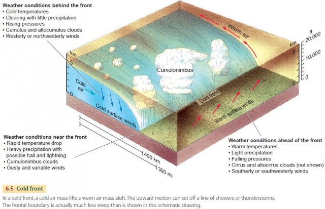
The result is a cold front, shown in Figure 6.5. Because the cold air mass is colder and therefore more dense than the warmer air mass, it remains in contact with the ground. As it moves forward, it forces the warmer air mass to rise above it. As the warm air mass rises, it cools adiabatically, water vapor condenses, and clouds form. If the warm, moist air is unstable, severe convection may develop. A cold front often forms a long line of massive cumulus clouds stretching for tens of kilometers.
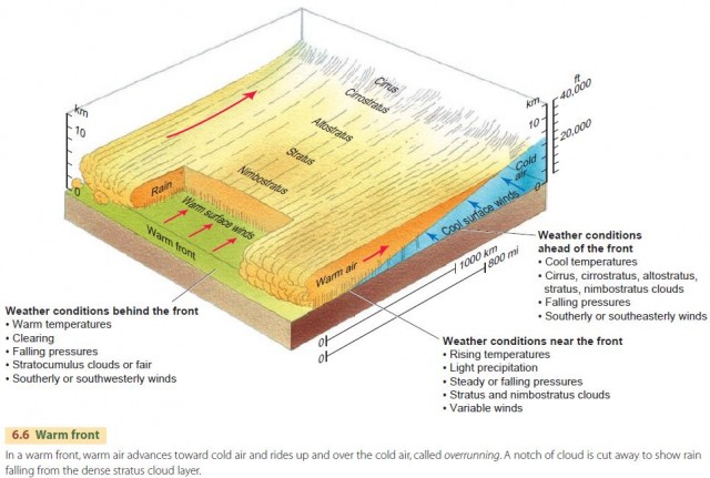
In contrast to a cold front, a warm front is a front in which warm air moves into a region of colder air, as the cold air retreats (Figure 6.6). Again, the cold air mass remains in contact with the ground because it is denser. As before, the warm-air mass is forced aloft, but this time it rises up on a long ramp over the cold air below. This rising motion, called overrunning, creates stratus—large, dense, blanket-like clouds that often produce precipitation ahead of the warm front. If the warm air is stable, the precipitation will be steady. If the warm air is unstable, convection cells can develop, producing cumulonimbus clouds with heavy showers or thunderstorms.
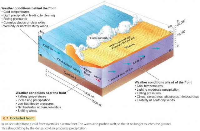
Cold fronts normally move along the ground at a faster rate than warm fronts because the cold, dense air behind the cold front can more easily push through the warm, less dense air ahead of it. The motion of the warm front, which depends on the retreat of the cooler air ahead of it, is slower. Thus, when a cold front and a warm front are in the same region, the cold front can eventually overtake the warm front. The result is an occluded front. (“Occluded” means closed or shut off.)
The colder air of the fast-moving cold front remains next to the ground, forcing both the warm air and the less cold air ahead to rise over it, as shown in Figure 6.7. The warm air mass is lifted completely free of the ground. A fourth type of front is known as the stationary front, in which two air masses are in contact but there is little or no relative motion between them. Stationary fronts often arise when a cold or warm front stalls and stops moving forward. Clouds and precipitation that were caused by earlier motion will often remain in the vicinity of the now stationary front.
A final type of front—called a dry line—can form along the boundary between hot, dry, continental tropical (cT) air and warm, moist, marine tropical (mT) air. Dry lines are usually found out ahead of cold fronts where southerly and southwesterly winds bring subtropical air from the continental regions and marine regions into contact with one another. Very strong thunderstorms can form along these dry lines as the hot, dry air mass mixes with the warm, moist air mass, increasing its temperature and making it very unstable.