Canary Islands
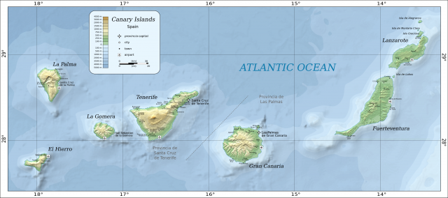
THE CANARY ISLANDS lie just 93 mi (150 km) off the northwest coast of Africa in the ATLANTIC OCEAN but have been politically and culturally attached to SPAIN, 830 mi (1,350 km) to the northeast, since the 14th century. Today the seven islands, an autonomous region of Spain, are among the most popular holiday destinations for tourists from northern Europe.
The islands' proximity to Africa is apparent in their climate, an extension of the deserts of the SAHARA. Some areas are semiarid, with abundant cacti and maspalomas (large sand dunes), while higher elevations host laurel and pine forests, with subtropical and tropical plants in the valleys in between. The islands are volcanic in origin and reflect this in their steep inclines and rugged cliffs. They vary in age and volcanic activity, from the oldest, Fuertaventura and Lanzarote in the east, to the most recently formed La Palma and El Hierro, furthest west in the chain. La Palma has seven volcanoes that have erupted since the 15th century, most recently Teneguia, in 1971. It also has a large collapsed caldera in the center of the island (Taburiente), with a rim averaging 6,600 ft (2,000 m) in height and an astronomical observatory.
Between these extremes of old and new islands at the eastern and western ends of the chain, lie the largest and most populated of the Canary Islands, Tenerife and Gran Canaria. Most of the beach resorts and nightclubs are on these two islands, but they too have their share of scenic ravines and mountain peaks—Pico del Teide is the highest point not only in the Canary Islands, but in all of Spain. Lastly, the small island of La Gomera, where isolation has best preserved the indigenous culture of the Guanches people, including their distinctive pottery made without a wheel, and the famous whistling language, Silbo, used by shepherds to communicate between sharp valleys and cliffs for centuries.
The Guanches are believed to be immigrants from North Africa, but legends name them as the only survivors of the lost continent of Atlantis. The ancient Greeks knew of the islands, as the last known land after the Pillars of Hercules (the Straits of Gibraltar). They were known as “the Happy Isles” before cartographers started calling them the Canaries—possibly due to the large hunting dogs (canis in Latin), still bred on the islands today (called verdinos or bardinos). But little was known about the islands until they were visited by a Genoese explorer, Lancellotto Malocello in 1312 (giving his name to Lanzarote). Ancient mariners drew the first meridian at El Hierro, marking the western edge of the world (today this is the west 18th).
Spanish monarchs established control over all of the islands between 1402 and 1504 and resisted repeated attempts by the Dutch and English to take the islands. The islands were coveted as the important last stop before setting off to cross the Atlantic, starting with Columbus himself, who last saw land at La Gomera on September 6, 1492. The islands formed two provinces, Santa Cruz de Tenerife and Las Palmas, until the reorganization of Spain into regions in 1984, which made the Canaries one region, with relative internal autonomy. Less than 10 percent of the gross domestic product is generated by agriculture, mostly bananas, especially on Tenerife, but also figs, grapes, and almonds in areas with a more Mediterranean climate. Rather, it is tourism—over four million visitors a year come to Tenerife alone—that contributes most to the local economy and provides residents with a per capita income higher than that of mainland Spain.