How Are We Warned About Severe Weather?
IN 1988, THE U.S. NATIONAL WEATHER SERVICE (NWS) began an aggressive program to modernize its capabilities in severe weather detection, forecasting, and communication, in support of its mission to protect life and property. As this program was implemented, weather forecasts have shown amazing improvement, particularly in severe weather advisories. The centerpiece of this modernization was the installation of Doppler radar at each of its 122 locations in the U.S. and its territories. Weather-service organizations in other countries have made similar progress in deploying instruments and improving forecasts.
How Does Doppler Radar Work?
Doppler radar is valuable because it tells us not only about the movement of storm systems (as conventional radar does), but also about mass and movement within individual storm clouds. We can observe real-time Doppler radar images of storms, tracking their progress on weather broadcast and cable channels, websites, and even apps on our phones, tablets, and game consoles.
Doppler Radar Facilities
1. In a Doppler radar facility, the transmitter emits microwave energy in all directions. When the radiation encounters an object, it will be reflected in various directions, including back toward the facility. In accordance with the Doppler effect, the wavelength of the return signal increases as the reflecting particle moves away from the transmitter and decreases as it moves toward the transmitter. Using this principle, Doppler radar can calculate the directions and velocities of water drops in clouds and of raindrops, snowflakes, and other forms of precipitation.
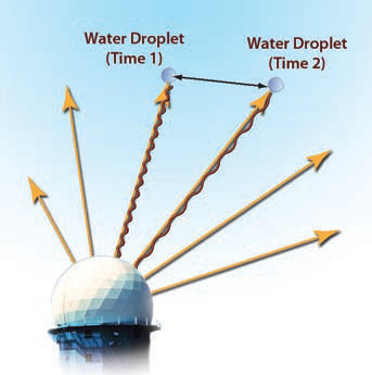
2. A receiver at the same facility measures radar signals reflected by solid and liquid particles in the atmosphere in all directions from the facility. The system can calculate the distance that particles have moved between two time periods, here labeled Time 1 and Time 2. By knowing the distance and how long it took to travel that distance, we can calculate the velocity. By knowing the velocity at different times, we can calculate accelerations. Doppler radar can keep track of the motions of millions of particles through time, deciphering an amazingly complicated array of signals. The resulting data and images vividly depict the complex motions of atmospheric masses. By analyzing the full assemblage of changes in wavelength associated with each reflection, we can measure the motion of every part of the system.
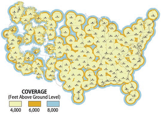
3. The effective range of a Doppler radar system is about 460 km (285 miles) for detecting the location and movement of precipitation, and about 240 km (150 miles) for detecting motion within a weather system.
Data from Doppler Radar
4. Doppler radar can detect motion within single- and multi-cell thunderstorms, and tropical cyclones, and the motion of the storms themselves, with greater precision and timeliness than other tools. This greatly improves forecasting of the likely track of a system, particularly for smaller storms that may go undetected by satellite. Many of the maps used to illustrate this chapter are Doppler radar images.
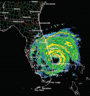
5. Using Doppler radar, the type and intensity of precipitation from the system can also be estimated. This Doppler radar image to the left shows details of the structure within Hurricane Frances in 2004, including the coiled shape. By analyzing such data for multiple time increments during a storm, maps can be produced showing storm totals, which represent how much total precipitation fell in each area as a result of the entire storm.
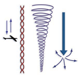
6. Doppler can also detect rotating motion within storms such as in mesocyclones, tornadoes, derechos, and microbursts. Many tornadoes touch down sometime after a mesocyclone begins forming and rotating, so meteorologists at the NWS can often issue a tornado warning more than 30 minutes before a predicted tornado touchdown. Although Doppler cannot yet distinguish mesocyclones that will spawn a tornado from those that will not, this capability will likely be available sometime in the near future. Software systems at NWS automatically alert meteorologists of zones of Doppler-detected wind shear in the atmosphere, a potentially life-saving feature.
What Are Some Limitations of Doppler Radar?
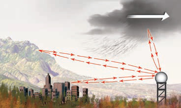
Like any technology, Doppler radar has certain limitations. Stationary objects, such as buildings and trees, reflect the Doppler radar beam, so these are part of the signal received by the receiver. Reflections from these non-weather objects are considered noise or false echoes. Objects causing false echoes are collectively referred to as ground clutter. Most of these objects are not moving, so they are relatively easy to recognize on the radar signal. They are filtered out using computing software that assumes that echoes that do not move for a predetermined period of time must not be precipitation. Ground clutter remains a problem, however, particularly in urban areas near the transmitter. In cities with numerous tall buildings, ground clutter can be so pervasive that data close to the city needs to be masked out, producing radar plots that have a central circular area with no displayed data. You have probably seen these on weather broadcasts.
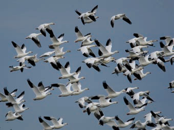
Birds are another source of false echoes. Echoes from birds are somewhat more difficult to isolate on the radar signal because, unlike buildings, birds move and are in the air, not on the ground. Also birds come in various sizes and can be locally numerous, especially during migrations.
Another limitation of Doppler radar is that some parts of the country are either not near a radar site or are shielded by topography, ground clutter, or even the curvature of the Earth. The network of Doppler radar stations across the U.S. generally provides adequate coverage, but there are some gaps. Similar networks of radar installations are present in southern Canada, most of Europe, eastern Asia, South Africa, Australia, and New Zealand. Many countries are not so well covered, if at all.
How Does the National Weather Service Alert the Public About Severe Weather?
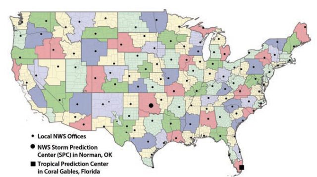
The NWS has local offices spread across the country. Local offices collect and analyze data, monitor the weather conditions, and relay this information into the vast computer network of the NWS.
In the U.S., the NWS Storm Prediction Center (SPC) in Norman, Oklahoma, analyzes these data and issues storm watches when conditions in an area are favorable for life-threatening thunderstorms, tornadoes, winter storms, and strong winds. Watches usually cover a broad area, sometimes larger than an average-sized state. Flood watches are issued by the NWS in cooperation with one or more of the 14 National River Forecast Centers.
By contrast, a warning of any of these severe weather types indicates more imminent conditions than a watch. The NWS issues warnings as bulletins that specify the location of the observed severe weather, its anticipated path, and the time that it is expected to occur at various locations in the warning zone. Except for the case of hurricanes, warnings are issued by the local NWS office. Warnings usually cover a much smaller area of predicted damage, such as a county or two, and also have a more focused time when damage is expected. A watch may be in effect for several hours, but a warning can be about an event that potentially will occur minutes after the warning is issued.
As soon as a severe weather watch is issued for your area, move to a sturdy shelter and stay alert to the weather by listening to the radio or watching TV. During a warning, immediately seek the safest location within that shelter by moving away from windows and toward the most reinforced parts of the structure, such as a bathroom, basement, or interior hallway or closet. Mobile homes are inadequate shelters in any type of severe weather.