Volcanic Landforms
Landforms are the surface features of the land—for example, mountain peaks, cliffs, canyons, plains, beaches, and sand dunes. Landforms are created by many different processes that we will describe in the remainder of this book. Geomorphology is the scientific study of the processes that shape landforms. In this chapter, we will look at landforms produced directly by volcanic and tectonic processes.
INITIAL AND SEQUENTIAL LANDFORMS
Continental landscapes reflect a tug-of war between two opposing processes. Volcanic and tectonic processes bring fresh rock to the planet's surface. We call these endogenic processes because they work from within the Earth. They produce initial landforms. In opposition are exogenic processes that work at the Earth's surface. They lower continental surfaces by removing and transporting mineral matter through running water, waves and currents, glacial ice, and wind. Exogenic processes wear down initial landforms to create sequential landforms. Figure 12.2 shows how an initial landform, produced by crustal activity, is carved into sequential landforms by erosion.
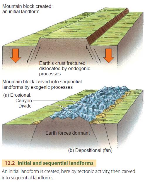
Where does the power to lift molten rock and rigid crustal masses from within the Earth to the surface come from? Natural radioactivity in rock in the crust and mantle creates heat energy. This radiogenic heat is the fundamental energy source for the motion of lithospheric plates. Because the internal Earth forces act repeatedly, new initial landforms keep coming into existence as old ones are subdued. Later in this chapter, we'll look at landforms produced by tectonic activity. But first, we'll look at volcanoes.
VOLCANIC ACTIVITY
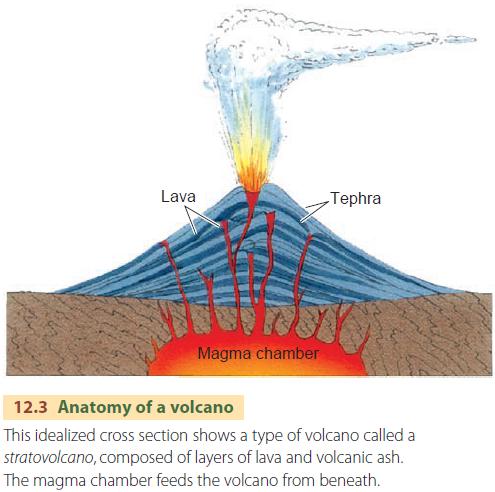
What exactly is a volcano? A volcano is a conical or dome-shaped initial landform that is built from lava emerging through constricted vents in the Earth's surface (Figure 12.3). Volcanism, or volcanic activity, constructs lofty cones of imposing mountain ranges as well as huge domes or plateaus of volcanic rock.
Volcanic eruptions are one of the most severe environmental hazards seen on our planet. During the Mount Pelee disaster on the Caribbean island of Martinique in 1902, for example, tens of thousands of lives were snuffed out in seconds. The destruction associated with volcanoes is caused by a number of related effects. Sweeping clouds of hot, incandescent gases descend volcano slopes at high speeds. Relentless lava flows can engulf whole cities. And showers of ash, cinders, and volcanic bombs (solidified masses of lava), all cause terrible devastation.
Violent earthquakes are also associated with volcanism. And for the inhabitants of low-lying coasts, there is the peril of tsunamis generated by undersea volcanic explosions. Thanks to scientific monitoring, we're now reducing the toll of death and destruction from volcanoes. Still, not every
volcano is well monitored or predictable.
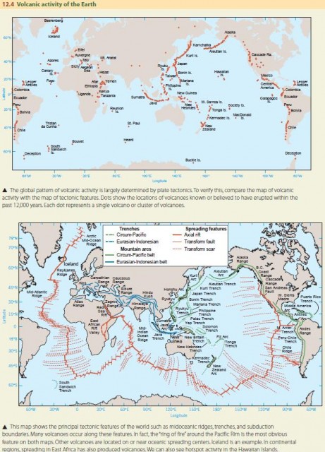
Where are volcanoes located? If you study Figure 12.4, you can see the close relationship between volcanic activity and plate tectonics, with many volcanoes located above subduction zones and in axial rifts.
STRATOVOLCANOES
Volcanic eruptions can be explosive or quiet. The nature of the eruption depends on the type of magma involved. There are two main types of igneous rocks—felsic and mafic—and each type builds a distinctive form of volcano—a stratovolcano or shield volcano, respectively (Figure 12.5).
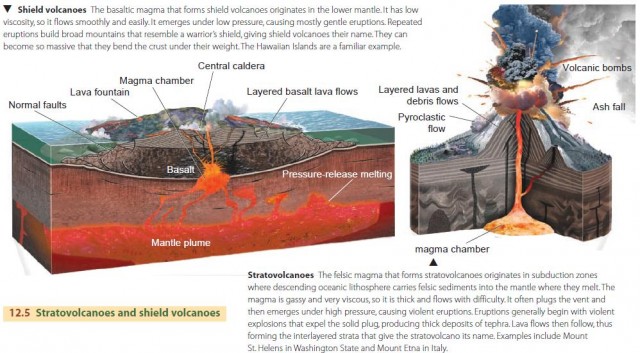
Felsic lavas (rhyolite and andesite) are very thick and gummy, resisting flow. So, felsic lava doesn't usually flow very far from the volcano's event, building up steep slopes. When the volcano erupts, ejected particles of different sizes, known collectively as tephra, fall on the area surrounding the crater, creating a cone shape. The sluggish streams of felsic lava and layers of tephra produce a stratovolcano. Its tall cone steepens toward the summit, where you find the crater—a bowl-shaped depression. The crater is the principal volcano vent.
Felsic lavas from stratovolcanoes hold large amounts of gas under high pressure, so they can produce explosive eruptions. Sometimes the volcanic explosion is so violent that it destroys the entire central portion of the volcano. Vast quantities of ash and dust fill the atmosphere for many hundreds of square kilometers around the volcano. The only thing remaining after the explosion is a great central depression, called a caldera. Although some of the upper part of the volcano is blown outward in fragments, most of it settles back into the new caldera.
Explosive stratovolcanoes also emit glowing avalanches (glowing clouds) such as the Soufriere Hills eruption of 1997 on Montserrat. These clouds of white-hot gases and fine ash travel rapidly down the flank of the volcanic cone, searing everything in their path. A glowing cloud from the 1902 eruption of Mount Pelee on Martinique issued without warning, sweeping down on the city of St. Pierre and killing all but two of its 30,000 inhabitants.
Most of the world's active stratovolcanoes lie within the circum-Pacific mountain belt, where there is active subduction of the Pacific, Nazca, Cocos, and Juan de Fuca plates. One good example is the volcanic arc of Sumatra and Java, which lies over the subduction zone between the Australian plate and the Eurasian plate.
Over time, exogenic processes erode stratovolcanoes, creating new landscapes. Erosion strips away their conical forms, leaving masses of resistant volcanic rock that continue to wear down. Ultimately, a landscape of lava mesas and volcanic necks with dikes remains.
SHIELD VOLCANOES
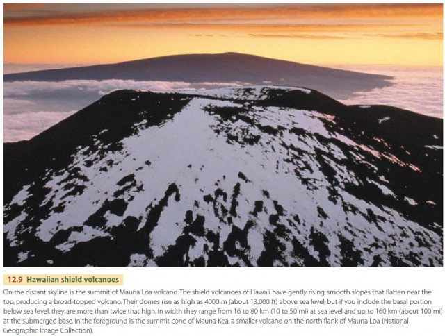
In contrast to the thick, gassy felsic lava that forms stratovolcanoes, mafic lava (basalt) is not very viscous and holds little gas. Eruptions of basaltic lava are usually quiet, and the lava travels long distances to spread out in thin layers. Typically, then, large basaltic volcanoes are broadly rounded domes with gentle slopes (Figures 12.5). They are called shield volcanoes. Most of the lava flows from fissures (long, gaping cracks) on the flanks of the volcano. The volcanoes of Hawaii are good examples, as shown by the profile of Mauna Loa in Figure 12.9.
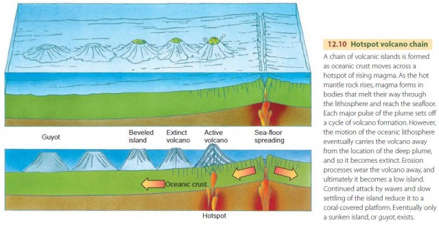
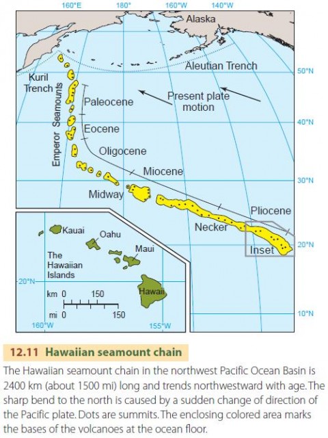
The chain of Hawaiian volcanoes was created by the motion of the Pacific plate over a hotspot—a plume of upwelling basaltic magma deep within the mantle. Motion of a lithospheric plate over a hotspot produces a long trail of islands and sunken islands called guyots. This process is shown in Figure 12.10. The Hawaiian trail is shown in Figure 12.11. Several other long trails of volcanic seamounts cross the Pacific Ocean Basin following parallel paths that reveal the plate motion. A few basaltic volcanoes also occur along the midoceanic ridge, where seafloor spreading is in progress.
Iceland, in the North Atlantic Ocean, provides an outstanding example. Other islands of basaltic volcanoes located along or close to the axis of the mid-Atlantic Ridge are the Azores, Ascension, and Tristan da Cunha.
Shield volcanoes show erosion features that are quite different from those of stratovolcanoes. The gentle slopes of the original volcano are replaced by steep canyons and sharp ridges as erosion dissects the mountain mass.
If a hotspot lies beneath a continental lithospheric plate, it can generate enormous volumes of basaltic lava that emerge from numerous vents and fissures and accumulate layer upon layer. These basalt layers, called flood basalts, can become thousands of meters thick and cover thousands of square kilometers.