What Might Happen If This Location Is Deforested?
YOU HAVE BEEN EMPLOYED by a county planning commission. You are asked to assess any possible impacts of logging (removing trees) of a mountainside in the area under your jurisdiction. To address the problem, you rely on your broad perspective and skills in the use of maps, satellite-image interpretation, physical geographic principles, and the scientific method. Then you will communicate your findings to policy makers and politicians on the commission.
Goals of This Exercise:
- Develop a list of observations about the area, accompanied by ideas of possible impacts of deforestation.
- Produce a list of questions you have about how different features and other aspects might be impacted by deforestation and how these might affect logging activities.
- Develop a list of the types of information you would need to answer your most important questions.
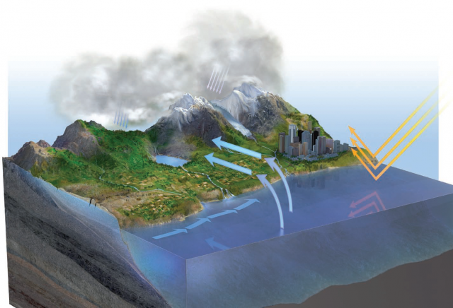
This three-dimensional perspective shows an area with a variety of terrains and climate. Make some observations about the landscape and record your observations on a sheet of paper or on the worksheet. As you study this landscape, record any questions you have about the impact of deforestation on the atmosphere, hydrosphere, lithosphere, and biosphere. The questions are what are important here, not the answers. You will be able to answer most or all of your questions by the end of the course. Include in your questions any you have about the potential impacts of deforestation on humans. Listed around the figure are some of the features and other aspects you should consider, but there are others not listed. Think broadly and be creative. We have listed a few questions to help you begin.
Slopes: How might the steepness of slopes interact with deforestation? Are steeper slopes more difficult or easier to log? What happens to soil if we remove vegetation on a steep slope? How about on a more gentle slope? Does erosion occur faster or slower on steep slopes?
Local climate: How cold is this place normally? Does most precipitation occur as snow or as rain, and how does this vary with the time of year? Is the precipitation spread out evenly over the year, or does it mostly occur during some seasons? If the winds are blowing from the water to the land, how do the mountains affect this moist air?
Procedures
- Examine the scene and make observations about the landscape. In your notes, write down what you consider to be the most important observations about the area.
- Think about how different features or aspects could be affected by deforestation, or how that feature or aspect could affect the proposed logging. Write down the most important questions that arise from your considerations. For example, what are the implications if the area has a relatively wet climate compared to a drier climate? How would removal of the trees affect erosion along the stream? Consider any other factors that might be important with regard to the issue but might not be obvious in the scene. For example, does the economy of this region depend on logging?
- List any types of information you would like to know about this location to answer your questions or further clarify the problem. When considering how logging could affect erosion of the slopes, for example, we would want to know whether the plan was to log steep slopes, gentle slopes, or both.
Optional Activities
Your instructor may have you complete one or more of the additional activities listed below. For these activities, type your answers into a word-processing document and submit this to your instructor in the manner in which she or he indicates (paper copy versus electronic copy).
- List all the layers you would you want to have in a GIS database to study the issue and any remote sensing techniques that would be needed to collect data.
- For two aspects that you consider during this investigation, generate a research question that addresses an important point capable of being answered using evidence in the form of data and observations. List the types of data you would need to answer these two questions and how you might collect them (field studies, satellites, etc.).
- For one of your two research questions, develop a well-conceived hypothesis — a statement, not a question, that explains what you suspect the answer to your question will be. Think about the various tools that a physical geographer uses. Which tools would you use to test your specific hypothesis?
- How Did Geographers Help in the 2010 Gulf of Mexico Oil-Spill Cleanup?
- What Is the Role of Time in Geography?
- How Do We Use GIS to Explore Spatial Issues?
- How Do We Use Global Positioning Systems and Remote Sensing?
- How Do We Use Maps and Photographs?
- How Do Map Projections Influence the Portrayal of Spatial Data?
- What Are Some Other Coordinate Systems?
- What Do Latitude and Longitude Indicate?
- How Do We Depict Earth’s Surface?