Atacama: The Oldest Desert: South America
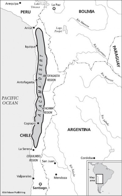
T he ancient, cold Atacama Desert might as well be on another planet. In fact, when scientists wanted to find a place harsh enough to test the robots they planned to send to Mars to look for the faintest, most beleaguered traces of life, they came first to this 700-mile-long (1,100 km) desert in northern Chile, where some areas go 17 years without a trace of rain.
The Atacama Desert remains the planet's oldest and driest desert, perched on a ledge of rock between the massive, jutting Andes Mountains and the 1,500-foot-high (500 m) wall of rock and cliffs that plunges into the Pacific Ocean. Just offshore lies the six-mile-deep (9.65 km) Atacama Trench, a rift along the edge of two crustal plates that helps sustain this high desert.
The Atacama Desert lies mostly between the south bend of the Loa River and the mountains that separate the Salado-Copianpo drainage basins running north to the border with Peru. The desert is divided by a line of low costal mountains, which are really 5,000-foot-high (1700 m) foothills to the Andes.
The desert itself consists mostly of great flat areas covered by pebbles left behind when the wind blew away the sand and the memory of topsoil, much of it at an elevation of about 3,000 feet (1,000 m). Low-lying salt flats at the foot of the coastal mountains mark the location of lakes that dried up long ago. Small sand dunes cover less than 10 percent of the desert, as the wind continues to sort through sand delivered to this low, waterless region millions of years ago.

The coast of Chile lacks the wide, fertile coastal plain that marks most continental edges. Instead, the coastal mountains go right up to the edge of the ocean, where 1,000-foot-high (304.8 m) cliffs drop straight into the sea.
In portions of the Atacama, 16,000-foot (4,877 m) volcanic cones rise from the flat, leafless plain. These volcanoes are driven by the same jostling of continents that continues to raise up the Andes and that dug the long, undersea trench running just offshore.
In stark contrast to the Sahara, the Atacama is a cold desert as a result of the high elevation and its position on the globe. Summer temperatures in most areas average just 66°F (19°C). The nearby ocean generates regular fog banks and cloud banks, but virtually no rain. Some areas routinely go without a trace of rain in a year and some can remain dry for decades. When storms do break through the natural barriers, they can sometimes deliver a scouring deluge. However, that happens about once every 25 to 50 years.
The Atacama has been a desert for more than 150 million years, according to recent studies. That makes it by far the oldest desert on the planet. But 150 million years is an unimaginable amount of time for a place to remain climatically stable. Remember, just 200 million years ago, all of the continents on the planet were assembled into a single supercontinent, on which the first dinosaurs roamed and roared. Back then, Africa and South America were pasted together, as were North America and Europe. So why has the Atacama remained a desert as the planet has changed around it?
Reconstructing the climate of the Atacama for the past 150 million years ago took some remarkable scientific detective work, according to a study by a team of British and South American scientists published recently in the Journal of the Geological Society of London. They pulled together many other studies of the mostly volcanic rocks found in that desert. When molten rocks cool, tiny magnetic minerals in the magma align with the north and south magnetic poles of the planet. Once the rock cools, those tiny, natural compasses remain locked into position, aligned on a north-south axis. If the continent on which the rocks rest moves, the magnetic particles in the rocks do not realign themselves.
Moreover, periodically, the poles of the Earth flip-flop, so north becomes south. No one understands why this happens, but it is related to convection currents in the Earth's semimolten core. The core remains molten because many rocks have a natural radioactivity, so they generate a tiny amount of heat as they degrade, which increases with depth in the Earth. Given enough heat, the rocks melt. This flip-flopping of the Earth's magnetic poles is preserved in the magnetic orientation of the elements in magma and can serve as a geological clock. Therefore, geologists can use the magnetic orientation of minerals in these volcanic rocks to figure out where those rocks were sitting when they cooled and the magnetic flecks pointed north. All of that enabled geologists to pinpoint the location of the Atacama Desert throughout the past 150 million years.

In addition, geologists can figure out past climate from looking at fossils and layers of sediments in ancient lake bottoms, river courses, and other areas. Fortunately, the geologists trying to figure out the history of the Atacama Desert had a wealth of well-dated sedimentary layers and ancient lakebeds to assemble into their geologic jigsaw puzzle. They concluded that the chunk of South America that contains the Atacama Desert reached its present position 150 million years ago. At that point, it got caught by the Atacama Trench, which runs along the edge of a crustal plate. And when it comes to making a desert, that old real estate adage applies—location, location, location.
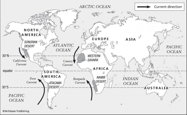
The Atacama developed as a desert for three main reasons. First, it sits in a spot where cold, dry air descends to the Earth's surface. The Earth's weather patterns are driven largely by the difference in temperature between the sun-drenched Tropics and the ice-shrouded poles, which is caused by the tilt of the planet. The equator is hotter because the sun's rays hit it more directly than at the poles. The heated air at the equator rises and then flows either north or south as cooler air rushes toward the equator to take its place. As the hot tropical air rises, it cools and drops its moisture on the Tropics. Once it cools in the upper atmosphere, the now-dry air descends, creating deserts in most areas it reaches, including the Atacama.
Second, the Atacama had some bad luck when it comes to ocean currents. The solid wall of South America forms a barrier. As a result, a major current hits the west coast of South America and flows like a river to the north. This current draws cold, dense water out of the Atacama Trench. Drawn to the surface, this cold flow of deep water does not evaporate easily. It generates low, dense coastal fogs when it hits the warm air, but little of that moisture rises up into the sky to create rain clouds. As a result, the cold current smothers the coastal rains that the west coast of Chile might otherwise expect. Fossil and geological evidence suggest that this cold, coastal current has dominated weather patterns in the Atacama for 150 million years.
Third, Atacama lies in the rain shadow of the Andes Mountains. Rainstorms and prevailing winds generated in the tropics on the other side of South America east of Brazil cannot get over the 20,000-foot-high (6,096 m) barrier of the Andes without being forced up so high that they lose their moisture as rain or snowfall.
The team of geologists scoured the desert to find rocks that would give them some clue as to the climate that existed in the Atacama before it was a desert. They expected to find wet and dry periods, like the shifts that geologists have discovered in deserts like the Sahara. Instead, they found strong evidence that the Atacama has been locked in a desert climate with little relief for 150 million years. To their surprise, they found that the area was a desert long before continental shifts caused the Andes to begin rising some 30 million years ago, which means that the location on the globe and the cold, offshore current were more important factors than the rain shadow of the Andes.