Economy
Chile has one the world's best performing economies. A measure of a country's economic performance is the Gross Domestic Product (GDP). The GDP is the value of all goods and services produced by a country. From 1990 to 2000, Chile's GDP grew 5.2 percent annually. This was the highest rate of GDP growth among all Latin American countries and one of the highest rates in the world.
Chile depends heavily on exports to make its economy grow. Mining makes up more than 40 percent of the total value of exports. The country's main mineral exports are copper ores and refined copper (20 percent of total exports). Other exports include industrial products, fruits and vegetables, paper and paper products, and chemical and petroleum products. The main importers of Chilean products are the United States, Japan, the United Kingdom, and Brazil. Chile's imports are lower in value than its exports, resulting in a positive trade balance. The main imports are mechanical and electrical equipment, mineral products, chemicals, textiles, transport equipment, metal and metal goods, synthetic plastic, and rubber. The United States is the principal exporter to Chile, followed by Argentina, Brazil, China, and Japan.
FREE TRADE AND THE GLOBAL ECONOMY
Foreign business investments fuel Chile's exports and economic growth. The nation attracts foreign investment because of its free trade policy. Chile's policy does away with barriers to trade. The policy eliminates nearly all taxes on goods of foreign countries entering or leaving the country. In 2003, Chile was the only country in Latin America that qualified as having a barrier-free economy, according to a study by the Heritage Foundation and The Wall Street Journal. In fact, only 16 of 165 countries worldwide had a free economy that year. (The United States was one.)
Because of Chile's free trade policy, foreign companies have invested large sums of money and capital in the country. These investments have created businesses, jobs, and income for Chileans. In the 1980s and 1990s, foreign investors focused on putting money in copper mining. By the early twenty-first century, investors had shifted their focus. They were buying and operating seaports and communication, gas, water, and electrical utilities. U.S. companies are the primary investors. Other companies are from Italy, Spain, Australia, and the United Kingdom. Direct foreign investments made up 50 percent of Chile's GDP in 2002.
Free trade among nations was the basis for an unprecedented expansion of the global economy in the 1990s. Few people know that the small nation of Chile helped ignite the expansion. In the mid-1980s, a handful of economists from the University of Chicago and the Chilean government put the world's first national free-trade policy in place. Many other countries, including the United States, promptly followed Chile's example. The movement toward free trade quickly snowballed to spur on the global economy.
In addition to its free trade policy, Chile appeals to foreign investors because it has a diverse economy in which to invest money. Expressions of that diversity are the country's distinct economic regions—the north, south, and middle. Each of these regions contributes to Chile's export-based economy.
Northern Chile
Mining and parched desert stamp a unity on this important economic region. Northern Chile corresponds to the administrative divisions of Tarapaca, Antofagasta, Atacama, and Coquimbo (or Regions I-IV, respectively). The collapse of the nitrate market at the end of World War I caused the sudden abandonment of mining towns in the region. Ghost towns from this collapse still dot northern Chile today. The surviving nitrate mines are in the Central Valley, between the latitudes of Iquique and Antofagasta. The main town is Maria Elena (population 12,400). The nitrates are part of the hard, salty crust that occurs in the Atacama Desert's dry lakebeds. A water pumping process dissolves the salts and places them into evaporation ponds. The scorching desert sun evaporates the water, leaving nitrate salt concentrations behind. The present mines supply sodium and potassium nitrates for making natural fertilizers. Iodine, lithium, boron, and magnesium are commercial by-products of the refining process. Chile is the world's leading producer of nitrates and lithium and the second largest producer of iodine (Bolivia is first). The north has about 75 percent of the world's nitrate reserves.
Copper is by far northern Chile's (and the nation's) most valuable export. The copper ore is near the earth's surface. The ore is in rocks along north-south geological fault lines. These faults align along the edge of the Andes Mountains. The mines also produce some silver, gold, and molybdenum, because the same geologic environment forms these minerals. Seven of the 10 largest copper mines in the world are in Chile; 5 of the 10 are in northern Chile (Table 3). Chile produces about one-third of the world's copper. The country has about 27 percent of the world's total reserves of copper ore.
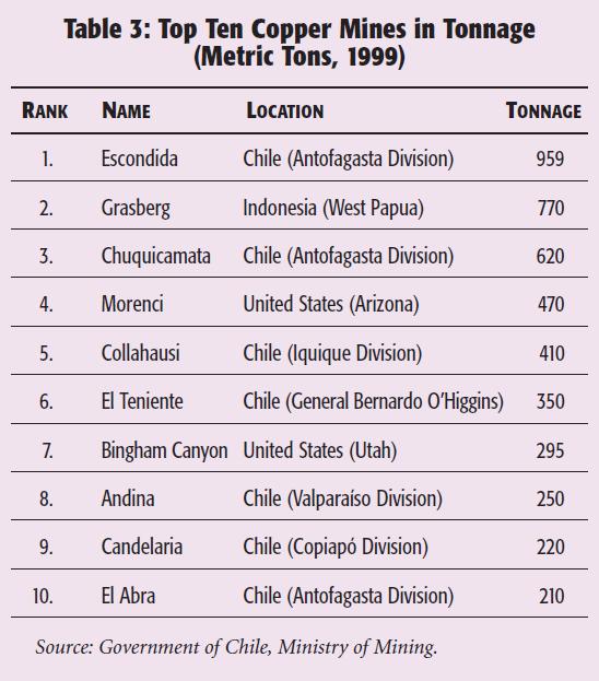
An international consortium (Australia, the United Kingdom, and Japan) operates the Escondida mine, the world's largest open-pit copper mine. The mine has been operating since 1990. The wide-open pit, which is made by gigantic digging and earth-moving equipment, accounts for 8 percent of the world's total production of copper and 22 percent of Chile's total production. Codelco, the government's largest state-owned mining company, operates the Chuquicamata mine. It is the world's third largest copper mine (the Grasberg mine in Indonesia is the second largest).
Since the early 1990s, direct investments by foreign companies have upgraded the copper smelting technology. (Smelting is the process of crushing and then melting a metal ore to remove non metal impurities.) The newer mining operations save money by exporting copper as concentrate (crushed ore from which most of the impurities have been removed).
The exporting of concentrate begins by adding water to the concentrate to make soupy mudlike slurry (a watery mixture of insoluble matter). A pump at the mine then moves the slurry from the mine to a coastal port through a nine-inch pipeline. Facilities at the seaport dewater the slurry and transfer it to ships for export. The country that imports the copper concentrate finishes the refining process by melting the concentrate into copper slabs.
Northern Chile's coastal ports supply goods and services to mining towns in the interior. As ports, they are outlets for the region's copper, nitrates, and refined by-products. Tocopilla (population 32,200), because of its location near principal nitrate plants, and Charnal (population 15,000), as the outlet for large inland copper mines, are important exporting ports. The nitrate industry also creates jobs in the coastal ports of Antofagasta (population 267,000) and Iquique (population 198,000). These ports are important fishing and regional supply centers, because they are also endpoints of the road and rail routes across Chile into Bolivia and Argentina. Arica is another large city of the region. It is the end of the only railroad link between Bolivia and the Pacific Ocean. This city has also taken on significance as a winter beach resort in recent years.
The nutrient-rich waters of the Humboldt Current are the basis for a large fishing industry. Chile ranks third in the world in fish catch (China and Peru are first and second, respectively). Northern Chile contributes a great deal to this ranking. The catch includes anchovies, jack mackerel, and pilchard. Iquique is one of the world's principal ports because of its huge fishmeal exports. Fishmeal is ground-up dried fish. Anchovies, in particular, make up this product. Fishmeal is high in protein and therefore an excellent livestock food supplement. Fish oil, a by-product of fishmeal production, is an additive for the manufacture of many items, ranging from margarines to inedible varnishes and waterproofing agents.
The largest inland desert city is Calama (population 148,000). The Loa River emerges from the Andes and provides a basis for modest agriculture there. Grapes are the main commercial crop. The town's economy is also dependent on serving tourists and the workers from the nearby Chuquicamata mine. A tourist guidebook states that most of the staggering wealth produced at the mine “is absorbed by the rest of the country, but enough of it remains to give this desolate outpost in the wilderness a chance to entertain itself.” Tourists stay overnight in Calama to visit the mine or to use the town as a base for excursions into the Andes.
Mining, agriculture, and pastoralism (raising livestock) form a trio of economic activity in the southern fringe of northern Chile. El Norte Chico (the Little North), as Chileans prefer to call this area, corresponds more or less with the Coquimbo administrative division (Region IV). Bethlehem Steel, a U.S. company, ran the world's largest iron mine between 1914 and 1954 at El Tofo. The company extracted the ore and shipped it from the Chilean port of Huasco to the Bethlehem Steel refinery and plant at Sparrows Point, Maryland. El Norte Chico has three iron ore mines now. An iron ore pellet plant at Huasco (population 8,100) supplies both domestic and foreign markets.
Small streams provide a basis for agriculture in the semiarid El Norte Chico. Small-scale irrigation for subsistence agriculture is the traditional economic activity in this semiarid land. The Copiapo, Limari, and Elqui valleys are famous for making piscoy a potent grape brandy that is popular among Chileans. Dried peaches, raisins, and figs are also national favorites. In recent years, vineyards for table grapes have become more widespread, the result of irrigation projects funded by outside investors. These vineyards are for the international market. Each summer, the area's table grapes are the first in Chile to ripen and the first to hit U.S. supermarkets, usually around Christmas.
El Norte Chico's rainfall is low in amount, but it is enough to support scattered grasses and livestock ranching. Government efforts to break up large haciendas (livestock ranches) in this region have not been as effective as in middle Chile, so the landholdings are relatively large. The climate is too dry and the soil too poor to divide the land into smaller ownership parcels. La Serena (population 149,600) and Coquimbo (population 160,000) are the principal towns of this transition zone. The town of La Serena is an agricultural service center and a popular tourist resort. Coquimbo is a seaport with a relatively good harbor. Waterpower from the Limari River is the basis for small industries in both towns.
Middle Chile
A Mediterranean climate, urban industry, and a rich agricultural economy stamp a unity on middle Chile. The region is made of the administrative divisions of Valparaiso, General Bernardo O'Higgins, Maule, and Bio Bio (Regions V-VIII, respectively), as well as Metropolitan Santiago. The area is the nation's smallest economic region, but it is Chile's most populous and wealthy region. The northern boundary is the Aconcagua River, and the southern limit is the Bio Bio River. Between these two rivers is a colorful mixture of agriculture, cities, and mining.
Middle Chile has more than 50 percent of the country's total agricultural landholdings. Grains occupy more than half the cropland. Wheat has been the most important grain crop there since colonial times. Fruit occupies much of the remaining land. Largely because of middle Chile's diverse production, Chile leads the Southern Hemisphere in fruit exports. Vineyards for table grapes and for making wine take up more land than any other fruit crop. Orchards of apples and avocados are also extensive in hilly sections of the region. Other fruits include lemons, oranges, nectarines, kiwifruits, cherries, raspberries, and strawberries.
The livestock industry is important to the economy as well. Land reforms have broken up most of the large haciendas, but there are still numerous smaller livestock-raising businesses. These operations use much of their land to raise animal feed. The ranchers feed the animals (cattle, sheep, and hogs) homegrown oats, barely, and corn. Towns nearby are service centers for the industry. They process livestock products, including leather goods (such as hats, shoes, and belts), woolen textiles, and meat products.
Metropolitan Santiago dominates the urban landscape. With a population of about 6.5 million people in 2003, the metropolis sprawls out over what used to be productive farmland. A main north-south corridor of road and rail lines connects Santiago to other industrial cities and market towns in the valley. Secondary lines, running east and west from the corridor, connect coastal and Andean foothill settlements. As in most urban hierarchies, the bulk of the people, goods, services, and money that enter this transportation network end up going to the largest urban center, Metropolitan Santiago.
Metropolitan Santiago's economy is so powerful that it dominates the entire nation. The metropolis employs about 40 percent of all the workers in the country. People find work in tourism, restaurants, hotels, department stores, and so on. They also find work in governmental, educational, and financial institutions. Many industries employ people to process farm and livestock products. Manufacturing is also a major source of jobs. Each year, Metropolitan Santiago's robust economy produces 40 to 45 percent of the nation's manufactured goods.
Four additional cities also contribute a great deal to middle Chile's urban economy. They are Valparaiso, Vina del Mar, Concepcion, and Talcahuano. Valparaiso (population 296,000) is Santiago's main seaport. This city has an attractive coastal setting and draws thousands of tourists each year. Visitors come to enjoy the city's vistas, fresh seafood, and cafes. The city also draws visitors for its theaters, parks, colonial buildings, and museums. This city is the nation's second busiest seaport, with extensive dock facilities to handle the bulk of the country's imports. Most of the imports go directly to Metropolitan Santiago. Valparaiso also manufactures chemicals, textiles, paint, leather goods, clothing, metal products, vegetable oils, and sugar. In recent years, the port of San Antonia, 30 miles (50 kilometers) south of Valparaiso, has been handling more cargo than any other port in Chile.
Vina del Mar (population 328,000) is Valparaiso's northern neighbor. The city started in the nineteenth century as a resort haven for Valparaiso's growing middle class. Today, Vina del Mar's stylish hotels, glitzy nightclubs, and first-class restaurants make it a vacation spot for Chile's affluent upper class and foreign tourists. Many wealthy Chileans and other Latin Americans own second houses there. Even the president of Chile sometimes stays in Vina del Mar in a government-owned holiday villa. The city generates income from some industrial development, as well as from tourism and recreation.
The city of Concepcion (population 222,000) is the center of economic activity on the southern fringe of middle Chile. A favorable location near the mouth of the Bio Bio River permits the city easy access to the interior. An excellent harbor in Talcahuano (population 297,000) is nearby. As a result, Concepcion processes agricultural items (such as fruits) and forestry products (lumber and pulp, for example) from the Bio Bio valley and then exports the goods (such as jams, wood furniture, and paper products) through Talcahuano. Like Iquique in the north, the port of Talcahuano is an important exporter of fishmeal.
Concepcion also benefits from Chile's only steel mill, which is at nearby Huachipato. The mill is an integrated plant, meaning all raw materials—iron ore, coke (is coal from which most gases have been removed by heating), and limestone—are brought to one location to produce rolled steel. Iron ore pellets come from Huasco. Furnaces burn coke to provide the heat necessary to melt the ore. Mill operators make coke by importing small amounts of high-grade coal from local mines. Limestone comes from rock quarries on Guarello Island, which is in the Chilean archipelago. Limestone is added to melted ore to remove impurities. Industries in the city of Concepcion use Huachipato's rolled steel to fabricate a wide range of products.
Middle Chile's Bio Bio subregion is the nation's second largest coal-producing area (Magallanes in the far south is the largest). About two-thirds of the Bio Bio production comes from the Lota mines just south of Concepcion. Farther south, on the Lebu Peninsula, is an area of low-grade coal that extends under the sea. Another coalfield is in the Chiloe area. In addition to coal mines, middle Chile has seven Andean copper mines, two of them—the El Teniente and Andina mines—are among the world's top ten producers (Table 3). El Teniente is also the world's largest underground mine. The mine has been operating since 1905. It includes more than 1,250 miles (2,000 kilometers) of tunnels, although only 500 miles (800 kilometers) yield ore today. The copper ore is shipped out of the country through the port of San Antonio.
Southern Chile
A rainy climate and forestry, dairies, and fishing stamp a unity on southern Chile. This economic region begins at the Bio Bio River and ends at the arrow-point tip of Tierra del Fuego. Integrating the region into the nation's economy took more than a century of slow immigration by Chileans and Europeans. Even today, parts of the region are so isolated that they are without electricity or telephones. Three subregions compose southern Chile's economic landscape: North End, Aisen, and Far South.
The North End
Araucania and The Lakes administrative divisions (Regions IX and X) make up the North End. The transport pattern is similar to that of Mediterranean Chile. A medial (north-south) trunk links the main market towns of the Central Valley. Angol (population 56,000), Temuco (population 259,000), Valdivia (population 140,000), and Osorno (population 150,000) are on the route. Side roads link the coast and Andean foothills to the valley. The North End's central trunk ends in Puerto Montt (population 168,000). The port city is also the connecting point for travelers going north to Santiago and south to the remainder of southern Chile.
Virtually all the North End cities are small industrial centers. Their industries include flour mills, breweries, tanneries, and woodworking plants, based principally on local raw materials. Throughout the region, tourism is becoming an important source of income. The basis of tourism is the area's interesting mix of German, Mapuche Indian, and mestizo cultures. The area's scenic countryside and recreational activities also attract many visitors.
Forestry is the most important economic activity of the North End. Private companies have ownership of vast tracts of forest-covered land. Their sawmills dot the landscape. Timberladen trucks deliver logs to the sawmills. Farmers also cut trees for fuel and to be sold to sawmills. Band saws in the mills cut straight-trunk logs of fir and araucaria pine into narrow slabs of quality lumber. Chile's forestry industry also specializes in making wood pulp from chips. Each mill has a wood chipper that makes chips from low-grade wood. Pulp mills turn the chips into an oatmeal-like pulp. The mills turn the pulp into paper, cardboard, and particleboard products. The chemical industry also uses the pulp.
To conserve natural forest areas, the pulp industry depends heavily on fast growing, commercially planted trees, such as eucalyptus (from Australia) and radiata pine (from Austria). About half of Chile's pulp production comes from such trees.
Puerto Montt and Chiloe Island are the main pulp and lumber centers. Wood chips, pulp, lumber, and other wood products are the North End's most valuable exports. Japan, the United States, and Germany import most of these products.
The North End's agriculture takes place in areas where forests once stood. Unlike farmers in middle Chile, who export many of their crops to foreign countries, farmers in southern Chile sell most of their products to the domestic market. A common sight is dairy cows, beef cattle, and sheep grazing on the North End's lush pastures. This pastoralism is the basis for a growing dairy and meatpacking industry. The main market for this southern subregion's dairy and meat products is Metropolitan Santiago.
Many of southern Chile's North End crops are typical of temperate regions: apples, cherries, raspberries, and blueberries. Considerable quantities of sugar beets, potatoes, beans, and peas are also grown. A small linen industry depends on flax cultivation. The main commercial crop is wheat. The region's mild temperatures and relatively dry summer allow this crop to thrive in Araucania. In the Lakes Region, the climate is too wet and cool for wheat production. Ocean fishing and pulp production replace wheat as an important income sources there.
Aisen
Aisen is Chile's eleventh administrative division (Region XI). Most of this subregion of southern Chile consists of thousands of small islands, uninhabited save for a few hundred Alacaluf Indians. On the mainland, steep Andean slopes and water-filled valleys make the soil poor or nonexistent. Beyond the Andean crest are small areas of Chilean Patagonia, with its semiarid treeless plains and small streams.
Aisen is Chile's last resource frontier. Mining of copper, silver, lead, and zinc is in its infancy, as is harvesting the region's commercial timber and marine resources. The area remained isolated until the second half of the twentieth century. The only important town was Puerto Aisen. Hardy German immigrants had settled this lonely place, stuck at the end of an isolated fjord, in 1870. Puerto Aisen became the region's government and commercial center. Government officials rarely visited the outpost. Similarly, commerce was limited to an occasional supply ship plying the cold, fog-shrouded inland waterway between Puerto Aisen and Chiloe Island.
Aisen's mountains isolated the Chilean Patagonia even more. There were only a few struggling frontier cow towns there. Settlers from Argentina established these towns prior to 1940. These small communities were very much like those in the old west in the United States during the nineteenth century. Argentine cowboys (gauchos) tended to livestock. On days off, the gauchos often went wild in the towns. There was very little law enforcement, because the region was isolated from the seat of government in Puerto Aisen. There were a few rutted roads but none connected the towns to other parts of Chile. Virtually no products left Chilean Patagonia, aside from the scrawny cattle that gauchos herded to markets across the border in Argentina.
The frontier quality of Aisen began to change in 1976. In that year, the Chilean government began building the Southern Highway (Carretera Austral). The route today is mostly unpaved road with occasional ferry crossings. It starts at Puerto Montt and ends abruptly in southern Aisen, just beyond the small settlement of Cochrane. The road bypasses the government center of Puerto Aisen, although a branch joins the port to the highway.
The Southern Highway has changed Aisen. It has brought people into the region seeking jobs. Farmers are now selling crops—wheat, beans, rice, and fruit—to the growing local population. Livestock ranches and dairy farms are turning out commercial products in small amounts for national markets. Dairy and meatpacking plants also now operate in Puerto Aisen. Because of its strategic location on the highway, Coyhaique (population 49,000) has surpassed Puerto Aisen (population 27,000) as the largest population center.
The chief income source of the Aisen subregion is fishing, with Puerto Aisen being the area's main fishing port. Chile is the second largest exporter of salmon after Norway, thanks largely to Aisen's contribution of caught, as well as farmed, salmon. Besides salmon, the fish catch includes trout, hake, king clip, and sea bass. Bottom-dwelling marine animals, including sea urchins, octopus, scallops, shrimp, and crabs, are also important commercial products.
In many ways, life in Aisen is not much different than it was before the Southern Highway came to the region. Many things that urban dwellers take for granted—doctors, schools, telephones, and newspapers—are still scarce. There are more cars and trucks now. Buses operate, but they often run late or not at all. The most common means of transportation is still horseback or wooden-wheeled carts drawn by oxen.
Far South
Southern Chile's far south sub-region corresponds with Magallanes, (Region XII). A north-south line joining the crests of the region's mountains divides the far south into two spheres. West of the line, Magallanes' mountains have some of the most rugged terrain in South America. Mercilessly tom apart by glaciers, the mountains' western edge forms the south end of Chile's archipelago. The surviving heights endure an endless pummeling by frigid rain and howling winds blowing in from the Pacific. The severe weather gnarls and stunts trees. Understandably, economic activity in the western half of Magallanes is absent, save for an occasional oil-drilling rig, fishing port, or mining operation.
The area east of the mountainous divide is of more economic use. Protected to some extent by the mountains, this plainlike area escapes enough of the Pacific Ocean's fury to have several towns. The settlements are centers of commerce, petroleum production, and fishing ports. More than 80 percent of the population resides in Punta Arenas (population 132,000). The area around Punta Arenas has been Chile's primary area of sheep grazing since about 1880. The far south has yielded important quantities of wool for export ever since.
Despite the historical importance of wool, petroleum (oil and natural gas) is the primary income source for this subregion. In 1945, oil and gas were discovered on the island of Tierra del Fuego. The Magallanes (named for Magellan, the explorer who passed through the strait in 1519) Strait separates Punta Arenas from the island. Punta Arenas has become the center of a petrochemical industrial complex. The complex is the country's main domestic source of oil and natural gas.
Tankers transport the oil to refineries in middle Chile. Natural gas is liquefied in plants on Tierra del Fuego and then shipped by tanker to supply cities in middle Chile. Plants on the Strait of Magellan produce chemical fertilizer and methanol for export as well. The country's largest coal deposits are at Peket, a few miles west of Punta Arenas. The coal is strip mined, meaning the overlying rock is removed to create a broad open-pit mine. A power plant at Tocopilla (in northern Chile) uses the entire output of this mine.