High-Latitude Climates (Group III)
By and large, the high-latitude climates are climates of the northern hemisphere, occupying the northern subarctic and arctic latitude zones. But they also extend southward into the midlatitude zone as far south as about the 47th parallel in eastern North America and eastern Asia. One of these, the ice sheet climate, is present in both hemispheres in the polar zones.
The high-latitude climates coincide closely with the belt of prevailing westerly winds that circles each pole. In the northern hemisphere, this circulation sweeps maritime polar (mP) air masses, formed over the northern oceans, into conflict with continental polar (cP) and continental arctic (cA) air masses on the continents. Jet stream disturbances form in the westerly flow, bringing pools of warmer, moister air poleward into the region in exchange for colder, drier air that is pushed equatorward. As a result of these processes, wave cyclones are frequently produced along the arctic-front zone.
THE BOREAL FOREST CLIMATE (KOPPEN: Dfc, Dfd, Dwc, Dwd)
The boreal forest climate is a continental climate with long, bitterly cold winters and short, cool summers. It occupies the source region for cP air masses, which are cold, dry, and stable in the winter. Very cold cA air masses very commonly invade the region. The annual range of temperature is greater than that of any other climate and is greatest in Siberia, in Russia.
Precipitation increases substantially in summer, when maritime air masses penetrate the continent with traveling cyclones, but the total annual precipitation is small. Although much of the boreal forest climate is moist, large areas in western Canada and Siberia have low annual precipitation and are therefore cold and dry.
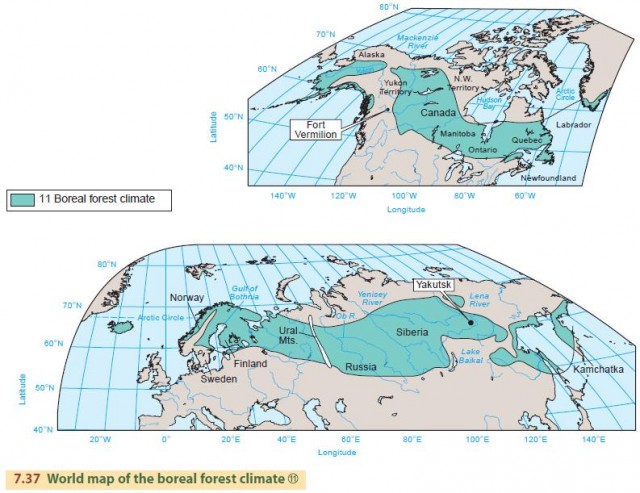
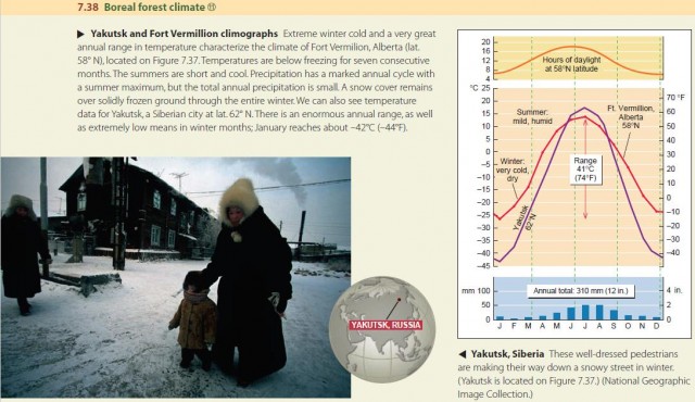
Figure 7.37 shows the global extent of the boreal forest climate , ranging from 50° to 70° N latitude. In North America, it stretches from central and western Alaska, across the Yukon and Northwest Territories to Labrador on the Atlantic coast. In Europe and Asia, it reaches from the Scandinavian Peninsula eastward across all of Siberia to the Pacific. Figure 7.38 shows a climograph for Fort Vermilion, Alberta, plotted alongside temperature data for Yakutsk, a Siberian city.
The land surface features of much of the region of boreal forest climate were shaped beneath the great ice sheets of the Ice Age. Severe erosion by the moving ice exposed hard bedrock over vast areas and created numerous shallow rock basins that are now lakes.
The dominant upland vegetation of the boreal forest climate region is boreal forest, consisting largely of needleleaf trees. Although the growing season in the boreal forest climate is short, it is still possible to cultivate crops. Farming is mostly limited to lands surrounding the Baltic Sea, bordering Finland and Sweden. Crops grown in this area include barley, oats, rye, and wheat. The needleleaf forests provide paper, pulp, cellulose, and construction lumber.
THE TUNDRA CLIMATE (KOPPEN: ET)
The tundra climate occupies arctic coastal fringes and is dominated by polar (cP, mP) and arctic (cA) air masses. Winters are long and severe. The nearby ocean water moderates winter temperatures so they don't fall to the extreme lows found in the continental interior. There is a very short mild season, but many climatologists do not recognize this as a true summer.
The world map of the tundra climate (Figure 7.40) shows this climate type ringing the Arctic Ocean and extending across the island region of northern Canada. It includes the Alaskan north slope, the Hudson Bay region, and the Greenland coast in North America. In Eurasia, this climate type occupies the Siberian coast, although tundra vegetation is also found on northern Iceland and along the arctic coast of Scandinavia. The Antarctic Peninsula (not shown in Figure 7.40) also belongs to this climate. The latitude range for this climate is 60° to 75° N and S, except for the northern coast of Greenland, where tundra occurs at latitudes greater than 80° N.
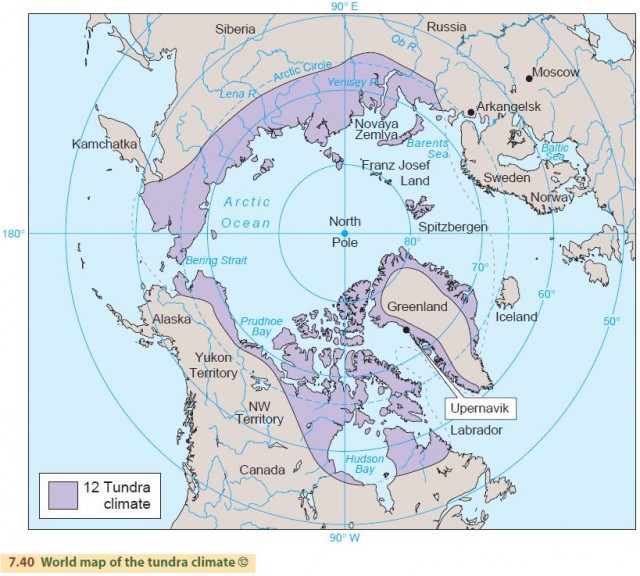
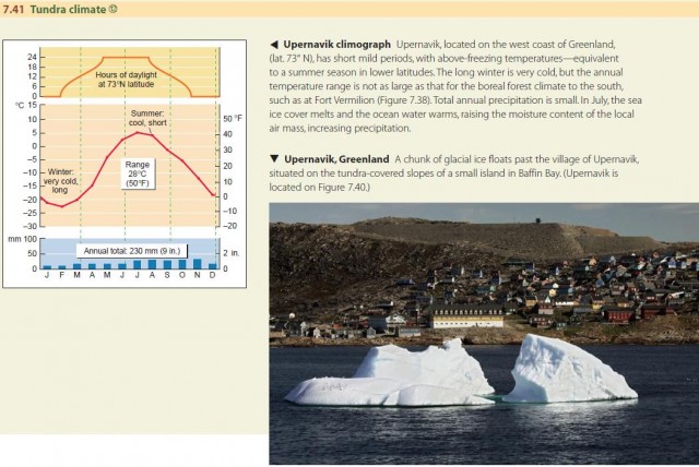
Figure 7.41 is a climograph for Upernavik, located on the west coast of Greenland at lat. 73° N. A short mild period, with above-freezing temperatures, is equivalent to a summer season in lower latitudes. The long winter is very cold, but the annual temperature range is not as large as that for the boreal forest climate to the south. Total annual precipitation is small. Increased precipitation beginning in July is explained by the melting of the sea-ice cover and a warming of ocean water temperatures.
This increases the moisture content of the local air mass, allowing more precipitation. The term tundra describes both an environmental region and a major class of vegetation. Soils of the arctic tundra are poorly developed and consist of freshly broken mineral particles and partially decomposed plant matter. Peat bogs are numerous. Soil water is solidly and permanently frozen not far below the surface, so the summer thaw brings a condition of water saturation to the soil.
Trees in the tundra are stunted because of the seasonal damage to roots by freeze and thaw of the soil layer and to branches exposed to the abrading action of winddriven snow. In some places, a distinct tree line—roughly along the 10°C (50°F) isotherm of the warmest month—separates the forest and tundra. Geographers recognize this as the boundary between boreal forest and tundra. Because of the cold temperatures experienced in the tundra and northern boreal forest climate zones, the ground is typically frozen to great depth. This perennially frozen ground, or permafrost, prevails over the tundra region. Normally, a top layer of the ground, 0.6 to 4 m (2 to 13 ft) thick, will thaw each year during the mild season.
THE ICE SHEET CLIMATE (KOPPEN: EF)
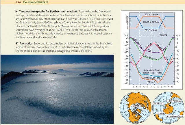
The ice sheet climate coincides with the source regions of arctic (A) and antarctic (AA) air masses, situated on the vast, high ice sheets of Greenland and Antarctica and over polar sea ice of the Arctic Ocean. Annual mean temperature is much lower than any other climate, with no monthly mean above freezing. Strong temperature inversions, caused by radiation loss from the surface, develop over the ice sheets. In Antarctica and Greenland, the high surface altitude of the ice sheets intensifies the cold. Strong cyclones with blizzard winds are frequent. Precipitation, almost all occurring as snow, is very low, but the snow accumulates because of the continuous cold. The latitude range for this climate is 65° to 90° N and S. Figure 7.42 compares temperature graphs for several representative ice sheet stations.
