What Climates and Weather Would Occur Here?
PLANET S is a hypothetical replica of Earth. It has plate tectonics, oceans, and an atmosphere very similar to Earth’s. You will map the climatic zones on this planet, identifying cold and warm ocean currents, prevailing winds, potential locations of rain forests and deserts, places where the climate and topographic setting would be suitable for agriculture, and sites at risk for hurricanes.
Goals of This Exercise:
- Observe the general map patterns and photographs from different parts of the planet. Note any clues about likely weather and climate.
- Create a map showing probable climatic conditions, based on ocean currents and prevailing winds.
- Locate likely sites for rain forests, deserts, agricultural areas, and places where storms will strike land.
Procedures
Follow the steps below, entering your answers for each step in the appropriate place on the worksheet or online.
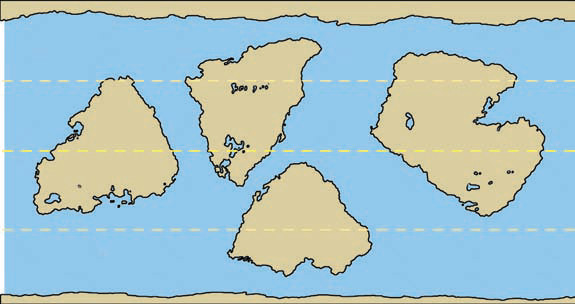
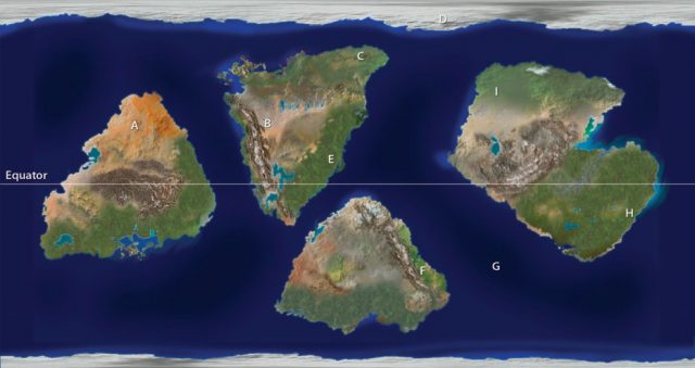
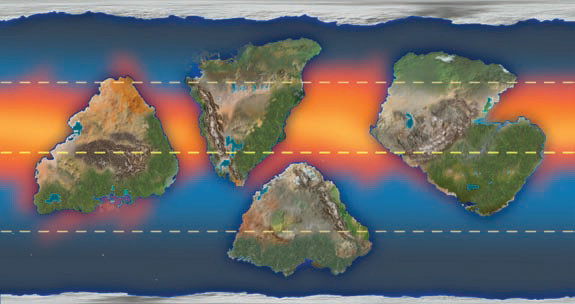
- Observe the distribution of continents and oceans on the map below and on the larger version on the worksheet. Examine the photographs of the various areas and infer the environments and climates that are represented. Each photograph has a letter that corresponds to a letter on the map. Some photographs are on the next page.
- Carefully examine the various types of data on the next page. For each data set, examine the climatic and weather implications for different parts of the planet.
- Draw on the worksheet your interpretations of whether each ocean current is warm, cold, or neither, and whether prevailing winds will bring warmth or coolness, and cause dryness or precipitation.
- Map the main climatic zones. Include the likely locations of rain forests, deserts, areas suitable for croplands, and areas at risk for hurricanes and other major tropical cyclones. Be prepared to discuss your observations and interpretations.
- Your instructor may provide you with climographs so that you can assign K?ppen climate types to different regions.
Some Important Observations About the Planet
- The planet rotates around its axis once every 24 hours in the same direction Earth does. Therefore it has days and nights similar to Earth’s. It orbits a sun similar to our own, at about the same distance. Its spin axis is slightly tilted relative to the orbital plane.
- The oceans are likewise similar to those on Earth. They show similar variations in sea-surface temperature and have ocean currents that circulate around the edges of the main ocean basins and in gaps between the continents.
- The planet has well-developed atmospheric currents, with wind patterns similar to those on Earth.
Preliminary Interpretation of Ocean Currents
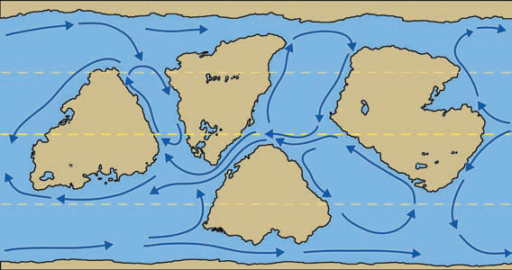
This map shows the directions of ocean surface currents. From these data, identify which currents are probably cold, warm, or neither. Water temperatures will be key in inferring probable climates.
Preliminary Interpretation of Wind Data
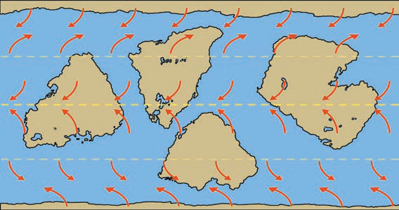
These data show the directions of prevailing surface winds, which are similar to the patterns on Earth. Different wind directions occupy bands encircling the planet, parallel to the equator.
Ocean Water Temperatures and Sea-Surface Pressures
This map depicts satellite data for sea-surface temperatures (SST) during late summer. The numbers give the temperature values in degrees Celsius (°C).
Climate Analysis
On the version of this map on the worksheet, show the probable locations of the following features by writing the associated letters on the map: rain forests (R), deserts (D), potential agricultural areas (A), and lands at highest risk for hurricanes (H). You can use colored pencils to shade in the extent of land associated with each letter. Your instructor may also have you assign likely Koppen climate types to different sites or regions. Complete this step on the worksheet.