Croatia: Physical Environment
In terms of its natural environment, Croatia is a tourist's dream come true. The country shares many similarities with California. Both are blessed with a very mild and pleasant Mediterranean climate. They both have long coastlines that rank among the world's most scenic. Each location has varied terrain, contributing to diverse landscapes and ecosystems.
Unlike California, however, Croatia has hundreds of coastal bays, inlets, and coves. Offshore, more than 1,000 islands of varying sizes rise above the sparkling clear blue water of the Adriatic Sea. As in California, immediately inland from the coast, the land becomes more rugged. In Croatia, however, the low, yet scenic, mountains offer the traveler some of the world's finest and most extensive examples of karst topography (landforms).Water, wearing away soft rock over thousands of years, has created an array of unique landform features. They include strange looking plateaus, valleys and hills, sinkholes, and rugged surfaces. There are also underground lakes and streams. But the best-known features in karst regions are caves. Croatia boasts of having more than 8,000 caverns, many of which have not yet been fully explored—the country is a spelunker's (a person who explores caves) paradise.
Still further east, the land flattens out to create fertile plains that produce most of Croatia's crops. Finally, scattered about the country are a number of national parks and other preserved environments that offer glimpses of unique landforms, ecosystems, animal life, and other geographic features.
Location
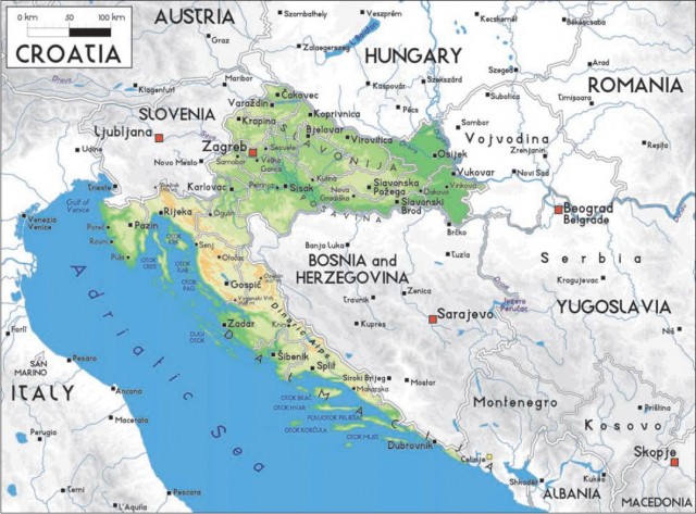
Look at the map of Croatia and use some imagination—doesn't the country's shape resemble the head of a huge (1,067 square miles; 2,763 square kilometers), eastward-facing alligator with its jaws opened wide? Within its gaping mouth is neighboring Bosnia and Herzegovina. Its long chin rests on the coast of the Adriatic Sea—a narrow extension of the Mediterranean Sea that separates Croatia from Italy, its neighbor to the west. The top of its head bumps up against its northern neighbors, Slovenia and Hungary. Finally, the tip of its snout is poking into northern Yugoslavia.
Location is perhaps the most important of all geographic concepts. And in this regard, Croatia is both blessed and cursed. It is blessed by occupying one of the world's most beautiful and unique landscapes. Also, it is situated in an ideal crossroads setting between the Mediterranean Sea and central Europe. To the south lie the historical treasures of the Mediterranean—Greece, Italy, and lands beyond. To the north are the heavily populated industrial countries of Europe. Today, as in the past, many important trade routes pass through Croatia. By vehicle, much of central Europe can be reached in an easy day's drive.
Croatia's location has also been a curse in some respects. The Balkan region has long been one of Europe's most troubled areas. It is an area in which deep ethnic hatreds have smoldered for centuries and often have broken into searing conflicts that have torn countries, ethnic groups, and even families apart.
During much of the 20th century, the region also fell behind the Iron Curtain—under the heavy fist of Communist control.Many of today's political, economic, social, and ethnic problems that plague the region can be traced to the influences imposed during this period.
The Land
From its narrow Adriatic coastal plain and its high and rugged western mountains, Croatia gradually drops in elevation to broad, fertile plains in the north and east. Geographers have divided the country into three general landform regions: the Adriatic coast, the interior highlands, and the eastern lowland plains. Each environment has different characteristics and different land use practices and potentials. The journey begins along the beautiful shore of the Adriatic Sea and works its way eastward through each of the regions.
Adriatic Coast
Croatia's coast is judged by many people to be one of the world's most beautiful shorelines. It stretches the entire length of the country's western, or Adriatic, border. Here, however, is a wonderful example of why it is necessary to exercise caution when interpreting statistical data. According to most sources, Croatia's coast extends for more than 1,100 miles (1,770 kilometers) along the Adriatic. Yet by taking a close look at a map and by using the distance scale, the distance from the northern to southern tip of the country, along the coast, is only about 300 miles (483 kilometers). The difference between the two distances provides the first glimpse of the nature of this coast—it is one of the most jagged in the world. In fact, only Norway, with its many fjords (long glacially scoured “arms” of the sea that reach far inland), has a more indented coastline.
Many islands—an estimated 1,185 of them—lie scattered about the waters off Croatia's Adriatic coast. Sixty-six of the islands are inhabited; others include various-sized islets, rocks, and reefs peaking above sea level.All of them, regardless of size, help to create yet another 2,500 miles (4,023 kilometers) of coastline. The largest islands are Krk and Cres. Both are located in the north, in Kvarner Bay, a shallow thumb of the Adriatic Sea tucked between the Istrian Peninsula and the mainland. The island of Cres is noted for a rather unique physical feature—there is a freshwater lake on the island. Jubuka, an island located nearly 60 miles off the southern Croatian coast, is volcanic. From the distance, it appears on the horizon like a black pyramid, with slopes plunging almost vertically into the sea.
The southern coastal region, called Dalmatia, is more rugged than in the north. Here, the Dinaric Alps plunge to the coast, leaving a narrow strip of rugged land with little flat terrain. The region is somewhat remote and also quite barren. But the combination of sea, islands, and mountain slopes makes this one of the country's most scenic regions. It also is a region that offers great potential for future economic development, particularly for tourism.
Interior Highlands
Immediately inland from the coast, the land becomes quite rugged and is less developed. Here, several parallel ranges of mountains form the Dinaric Alps. The area is often called Croatia's Switzerland. But the Dinarics are no match for the towering, snow-capped alpine ranges farther west, which stretch from eastern France into Austria. Much of the region lies at elevations of between 1,000 and 2,000 feet. And even the highest peaks reach only about 6,000 feet—somewhat lower than the higher Appalachian peaks in the eastern United States, or South Dakota's Black Hills. This region offers great potential for the development of winter tourism and various types of mountain recreation activities.
Eastern Lowland Plains
Much of eastern and northeastern Croatia is relatively low and flat, with the plains broken here and there by scattered hills and low mountains. The Drava and Sava rivers, both tributaries to the mighty Danube River, drain the region, known as the Pannonian Plains. In some areas, sluggish streams have created marshlands. But elsewhere, they have carried material eroded from their highland headwaters and deposited this material on the plains below. It is this alluvium (streamdeposited soil) that creates the rich soils that make this region Croatia's most important area of farming and livestock herding. It is also where most of the country's people live.
Climate and Ecosystems
Weather is the current atmospheric condition; climate is a many-year average of weather conditions. Ecosystems can be thought of as being the natural elements, or physical landscapes, that people actually “see” when traveling through climatic regions: the natural vegetation, the soils, the animal life, and the water features. Most of Croatia lies between 43 and 46 degrees north latitude, placing it at the same distance from the equator as Oregon and South Dakota. Yet because of its closeness to the Mediterranean Sea, its climate is much more like that of Oregon, than of South Dakota. It enjoys a relatively mild climate, one that lacks the extreme high and low temperatures of more interior locations. In the west, along the coast and in the western highlands, both the climate and ecosystem are Mediterranean—similar to the environmental conditions that occur in California west of the Sierra Nevada. In the eastern lowland plains, climate is humid continental, with conditions similar to those found in Missouri.
Mountains, of course, create their own climatic conditions. A 1,000-foot (305 meters) change in elevation can create the same change in temperature that one might experience in traveling through a 400-mile (644 kilometers) span of latitude.
Mediterranean Climate and Ecosystem
Generally speaking, temperatures are moderate along the coast. A dominant characteristic of the Mediterranean climate is its lack of extremes. It is also sunny much of the time—in fact, Croatia's Adriatic coast is one of the brightest in all of Europe, averaging 2,600 hours of sunlight yearly. Summers are warm, but not uncomfortably hot; winters, on the other hand, tend to be quite mild. The lack of extremes is explained by the sea's moderating effect on temperature.Water bodies do not get as hot, or as cold, as do adjacent landmasses. Therefore, temperatures on land bordering a large body of water tend to be more moderate than those occurring farther inland. The coastal city of Dubrovnik experiences a mild January temperature average of 48°F (9°C); frost and snow rarely occur. In July, the hottest month of the year, the temperature averages a pleasant 77°F (25°C), and scorching temperatures are almost unknown. Annual precipitation along the coast averages 25 inches (64 centimeters) to a maximum of 40 inches (102 centimeters). But the Mediterranean climate is unique in one important way—it is the only climatic region that experiences a prolonged period of summer aridity. Here, as in much of California, nearly all of the precipitation falls during the late fall, winter, and early spring months.
Winds are common to the coastal area. Sea-land breezes occur almost daily. During the day, coastal areas are cooled by sea breezes—winds blowing from the cooler sea over the warmer land. (Directional winds take the name of the direction from which they blow; therefore, a land breeze blows from land to sea, and a northeasterly wind blows from the northeast.) At night, direction changes as land-breezes blow from the interior toward the sea.
The strongest wind along the coast is the bora. It is a dry wind that can blow with very strong intensity from the north and northeast. During the winter, a bora can last as long as two weeks. It blows down from the mountains toward the sea, often howling through the passes and canyons. The strongest bora blows in the northern Adriatics, with average wind velocity gradually slowing down in southern Croatia. Along the entire Adriatic coast, however, these fierce winds can reach hurricanestrength proportions. They can cause tremendous damage to buildings and other structures, woodlands, and coasts.
The town of Senj, located at the western end of a mountain pass a short drive south from the city of Rijeka, is often the victim of the bora. Even Croatian folklore and literature recognize Senj's fierce bora storms. The wind is particularly strong here because of Senj's unique location. The bora is caused when an intense lowpressure system forms to the west and a strong high pressure system forms to the east. Just as water flows from high elevation to low elevation, air blows from an area of high atmospheric pressure to one of low pressure.When air blows from east to west in this region, the high mountains block it—just as a dam stops a river's flow. Senj, however, is located at the western end of a mountain pass that serves as a funnel for the moving air. As the wind blasts from the mouth of the pass, it often stops traffic along much of the Croatian coast. Another wind affecting the coastal region is the sirocco. This is a warm, moist wind that blows mostly from the south, bringing with it high waves and rain.
The Mediterranean ecosystem is unlike any other in the world. It is adapted to two primary controls. First, the region receives ample moisture for plant growth, but it also experiences a severe and prolonged summer drought. For this reason, many plants go into their dormant period during the summer, rather than winter, months. Second, because of summer drought, all Mediterranean regions (including southern California) experience widespread and often severe wildfires during the summer and early autumn months. The vegetation has adapted to these conditions, and is pyrophytic (fire resistant), composed mainly of grass, shrubs, and scattered small trees. Valley alluvial (streamdeposited) soils are fertile, although seasonal drought makes irrigation necessary for most crops during summer months.
Mountainous Interior
Moving inland, into the Dinaric Alps and associated ranges, weather conditions change abruptly.Here, elevation and exposure (north- or south-facing slope, determining exposure to the sun) are the primary influences on weather and climate. On the Adriatic-facing slopes, conditions resemble those of the lower coastal region to the west. In the mountains themselves, temperatures tend to be considerably lower (dropping by about 3.5°F (-17°C) for each additional 1,000 feet (305 meters) of elevation). During winter months, temperatures can plummet to below freezing. Croatia's lowest recorded temperature is a bonechilling -13°F (-25°C). Mountainous regions receive the highest amounts of precipitation to occur anywhere in the country, receiving an average 80 –120 inches (203 –304 centimeters) per year. Here, precipitation is more equally spread out through the year, and heavy winter snow is common.
Mountain ecosystems also vary with local conditions of weather and climate.At the same elevation on a hill, for example, the north-facing slope can be densely forested, whereas just a few miles away, on a south-facing slope, there is only sparse grass and scrub vegetation. The difference is explained by exposure to the sun. The south-facing slope receives more sunlight, hence it is warmer; this, in turn, results in greater loss of moisture through evaporation. Because of their relative lack of human settlement and extensive economic development,much of the mountainous environment remains forested. About 36 percent of Croatia is in woodlands, most of which occurs in this region. Deciduous woodlands predominate, with varieties of oak and beech being most common. In places, however, forests suffer from widespread air pollution (such as acid rain) and unwise deforestation. The mountains also abound in wildlife. Large animals include bear, deer, boar, wildcat, and wild sheep. There also are hare, fox, lynx, and wolves.Many species of birds are also found in the region.
Northern and Eastern Humid Continental
This region is Croatia's population and economic heartland. Here, the climate is similar to that of the more humid central interior of the United States. Summers are hot and humid, and winters are cool to cold. Summer temperatures have reached a sweltering 113°F (45°C); winter temperatures, on the other hand, can plunge well below 32°F (0°C) and occasionally below 0°F (-17°C). Zagreb, the capital and largest city, experiences a January temperature average of 32°F (0°C) and a July average of 75°F (24°C). These temperature conditions are almost identical to those throughout much of central and eastern Missouri. Originally, this region supported a dense cover of deciduous forest. However, thousands of years of human settlement, land clearing, and agriculture have destroyed nearly all of the original woodlands. Widespread marshlands also occur in some of the more poorly drained parts of the northern and eastern plains.
Water Features
Although the Adriatic coastal area of Croatia experiences prolonged and severe summer drought, nearly all of the country has adequate moisture for human settlement and economic development.
Croatia's major water feature is the Adriatic Sea. Because water in the Adriatic swirls in a counterclockwise direction, the sea has some of the cleanest water in the entire Mediterranean Sea (geographically, the Adriatic Sea is an extension, or part, of the Mediterranean). In places, objects on the bottom can be seen at a depth of more than 100 feet. The sea is rich in marine resources, including hundreds of edible fish and shellfish species.
Most of Croatia's rivers are in the east, where they flow from the surrounding mountains eastward into the Black Sea basin.Major rivers include the Sava, which flows from Slovenia southward, through Zagreb and across central Croatia, where it forms part of the southern boundary with Bosnia and Herzegovina before joining the Danube. The Drava River forms a large portion of Croatia's eastern boundary with Hungary and Yugoslavia. Even the mighty Danube touches a small part of the country's eastern tip. The west, you may recall, is a region of karst topography (limestone landforms).Whereas a few streams plunge down the western slopes of the Dinaric Mountains into the Adriatic, the region has few rivers. Karst is associated with limestone rock, which is very porous—that is, water sinks into the rock very quickly. Here, as in parts of Indiana and Florida (states with large areas of limestone and karst topography), many of the streams are underground.
About 90 percent of all natural lakes in the world were created by glacial action.The land that is now Croatia was too far south and too low in elevation to have undergone extensive Ice Age glaciation. Therefore, it does not have many lakes.And of the lakes that it does have, none of them is large. Lake Vrana, located south of Zadar on the northern Dalmatian Coast, is the country's largest freshwater body. There are several small reservoirs—which are artificial lakes on rivers behind dams. Perhaps Croatia's best-known and most unique lake is Vrana, a freshwater body occupying a depression on the island of Cres. In the karst region, water seeping into the earth has eroded rock and formed huge caverns.Many caverns are dry, or partially dry, caves; others, however, are filled all or in part with water to form enormous underground lakes.
Croatia also has a number of thermal (warm water) springs, all of which are located in the interior areas of the country. Water in some of the springs also has a high mineral content. The combination of warm and mineral rich water supposedly has healing properties. Hence, a number of the springs have given rise to important spas that attract thousands of people seeking their curative powers.
Mineral Resources
Croatia has a variety of useful mineral resources. Before the outbreak of regional warfare in 1991, mining and quarrying were important contributors to the country's economy. Of greatest importance are its mineral fuels. There are good deposits of petroleum, natural gas, and coal. In peaceful times, the country has the energy resources needed to build a strong industrial base. Additionally, there is some iron ore, bauxite (the ore from which aluminum is made), and clay suited to the making of chinaware.
Environmental Hazards
Although much of Croatia is quite safe from natural hazards, the country does offer some environmental elements that can result in devastation. In addition to the damage caused by the bora and its howling winds, heavy rains can cause problems in the mountains. Flash floods can occur, resulting in torrents of water sweeping down steep mountainsides causing serious erosion and destroying everything in their path. Landslides and mudflows, also usually occurring after periods of heavy rain, also pose a threat in the mountains. On the lowland plains, heavy rain or rapid snowmelt can cause widespread local flooding. And in the Dinaric Alps, particularly around the city of Knin, earthquakes occur rather frequently.
The country's major environmental threat, however, is wildfire. In this context, it is important to remember that coastal Croatia is similar to coastal southern California. Each summer, hundreds of fires ravage southern California's landscape—often causing millions of dollars in damage. In the Mediterranean climate, vegetation thrives during the wet winter months, but during the parched summer months, it dries out, creating an environmental tinderbox. A simple spark can ignite a match-sized flicker of flame that can become a raging inferno in a matter of minutes. Heat generated by the flames can create its own firestorm. As air rushes in toward the fire, it creates a bellows affect. This not only fans the flames, but also the resulting winds can reach 100 miles (162 kilometers) per hour—causing the entire fire system to move at an alarming rate of speed. Until finally stopped, searing flames and heat often in excess of 1,000°F (378°C) will destroy anything in the fire's way. Here, as in California, humans acting in a reckless and thoughtless manner create nearly 100 percent of all such fires.
Preserving the Environment
Croatia has taken steps to preserve large portions of its rich natural heritage. In fact, today about 8 percent of the country is protected parkland. And there are plans to almost double the country's area devoted to environmental preservation to 15 percent—a figure that is matched by very few other nations. The country takes great pride in its seven national parks.
Three parks are in mountain regions and four are scattered along the Adriatic coast. Paklenica Park is in the Velebit, Croatia's largest mountain range (part of the Dinaric Alps). Deep gorges, unique land formations, dense woodlands, rare plant species, and abundant wildlife make this park a tourist's paradise.
Risnjak Park is in the Gorski Kotar region, where it offers protection to the country's most densely wooded area. Plitvice National Park features 16 small lakes, connected by more than 90 waterfalls.
The coastal parks take advantage of the Adriatic region's natural beauty, including its freshwater, saltwater, many islands, vegetation and animal life, and distinctive karst landscapes. The National Park of Krka spotlights the Krka River as it cascades through deep canyons, creating lakes, waterfalls, and rapids as it plunges to the sea. Brijuni Park protects a group of 14 islands located offshore from Pula, at the tip of the Istrian Peninsula.
The more than 100 islands that make up the Kornati Archipelago—the largest island group in the Mediterranean—are the site of Kornati Park. Marine life, towering cliffs, and rugged coastal features add to the beauty of the islands themselves. Finally, in the far south, near Dubrovnik, is the Mljet National Park. Here, two lakes are linked with both the sea and to each other by narrow, nearly hidden, passageways.
Additionally, there are a variety of other parks and protected areas. These include nature parks, various reserves, natural monuments, protected nature areas, parks-forests, and various areas protecting special plant and animal species.
Much of Croatia has a pleasant, varied, and scenic environment. The country does not suffer from extremes of temperature, and its entire area receives adequate moisture to support settlement and economic development. Whereas much of the country is hilly to mountainous, elevations are relatively low; hence, they do not pose major obstacles. There are abundant fertile soils to support an agricultural economy.
And the country has both the fossil fuels and other minerals needed to support domestic industrial development. It is unfortunate that political conflicts in the recent past have discouraged tourism and hindered other environment-related aspects of the country's economy.