Cyclones and Anticyclones
THE CORIOLIS EFFECT
We have seen that the pressure gradient force moves air from high pressure to low pressure. For sea and land breezes, which are local in nature, this pushes wind in about the same direction as the pressure gradient. But on global scales, the direction of air motion is more complicated. The difference is caused by the Earth's rotation, through the Coriolis effect (Figure 5.13).
The Coriolis effect was first identified by the French scientist Gaspard-Gustave de Coriolis in 1835. Because of the Coriolis effect, an object in the northern hemisphere moves as if a force were pulling it to the right. In the southern hemisphere, objects move as if pulled to the left. This apparent deflection does not depend on direction of motion—it occurs whether the object is moving toward the north, south, east, or west.
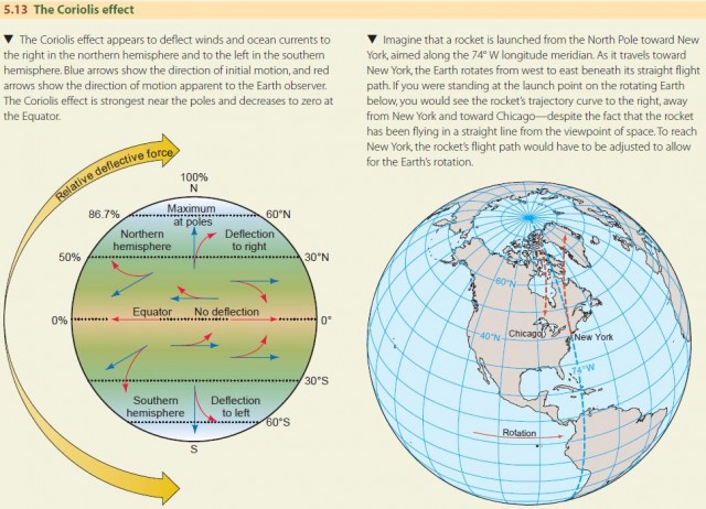
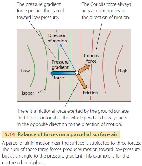
Geographers are usually concerned with analyzing the motions of air masses or ocean currents from the viewpoint of an Earth observer on the geographic grid, not from the viewpoint of space. So, as a shortcut, we treat the Coriolis effect as a sideward-turning force that always acts at right angles to the direction of motion. The strength of this Coriolis “force” increases with the speed of motion but decreases with latitude. This trick allows us to describe motion properly within the geographic grid (Figure 5.14).
CYCLONES AND ANTICYCLONES
We're used to seeing low- and high-pressure centers on the daily weather maps. You can think of them as marking vast whirls of air in spiraling motion. In low-pressure centers, known as cyclones, air spirals inward and upward (Figure 5.15). This inward spiraling motion is called convergence. In high-pressure centers, known as anticyclones, air spirals downward and outward. This outward spiraling motion is called divergence.
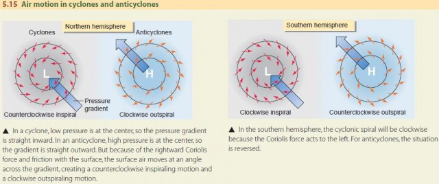
Low-pressure centers (cyclones) are often associated with cloudy or rainy weather, whereas highpressure centers (anticyclones) are often associated with fair weather. Why is this? When air is forced upward, it is cooled according to the adiabatic principle, allowing condensation and precipitation to begin. So, cloudy and rainy weather often accompanies the inward and upward air motion of cyclones. In contrast, in anticyclones the air sinks and spirals outward. When air descends, it is warmed by the adiabatic process, so condensation can't occur. That is why anticyclones are often associated with fair weather. Cyclones and anticyclones can be a thousand kilometers (about 600 mi) across, or more. A fair-weather system—an anticyclone—may stretch from the Rockies to the Appalachians. Cyclones and anticyclones can remain more or less stationary, or they can move, sometimes rapidly, to create weather disturbances.