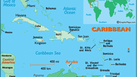
Aruba
A NETHERLANDS territory in the CARIBBEAN SEA and formerly the A in the ABC Islands, Aruba has come into its own in the past two decades, thanks in large part to aggressive advertisement campaigns on U.S. television. Already prosperous due to oil refineries established by the Dutch in the early 20th century, this advertising strategy […]
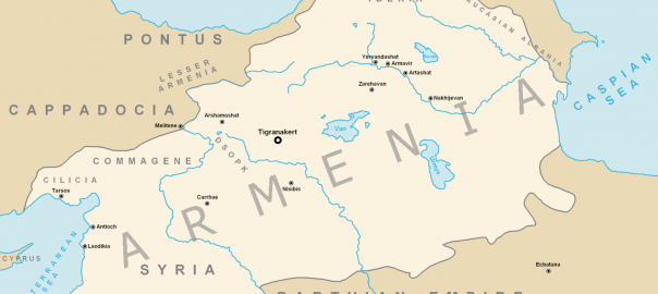
Armenia
Area 11,500 square mi (29,800 square km) Population 2.984 million 2014 Capital Yerevan Highest Point 13,418 ft (4,090 m) Lowest Point 1,312 ft (400 m) GDP $10.88 billion 2014 Primary Natural Resources hydroelectric potential. ARMENIA, LYING SOUTH of the towering CAUCASUS range and on the southwestern edge of Asia, is bounded to the north and […]
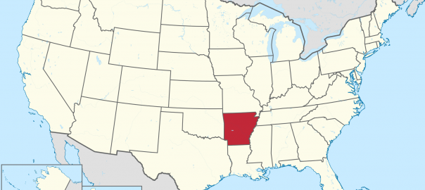
Arkansas
ITS NAME DERIVED from a French-adapted Native American term meaning “downstream people,” Arkansas is the 27th largest state at 53,104 square mi (137,539 square km). The state's shape is almost like a box, as its north-south extent is 240 mi (386 km) and the east-west extent is 275 mi (443 km). Located in the mid-Southwest […]
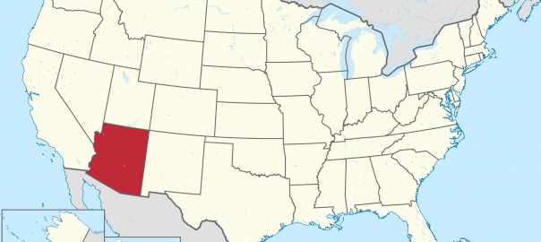
Arizona
A PLACE OF indisputable geographical interest in the U.S. Southwest, of which the GRAND CANYON of the Colorado River is but the leading example, Arizona currently exemplifies a trend toward urbanization in western states. While much of Arizona's land area of 113,635 square mi (294,315 square km) remains undeveloped, Arizona's capital and largest city, Phoenix, […]
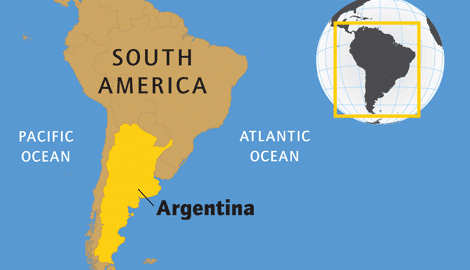
Argentina
Area 1,068,302 square mi (2,766,890 square km) Capital Buenos Aires Population 41.80 million 2014 Highest Point 22,834 ft (6,960 m) Lowest Point -344 ft (-105 m) GDP $540.2 billion 2014 Primary Natural Resources iron ore, petroleum, uranium. ARGENTINA IS A COUNTRY located in southern South America, the second-largest country on the continent. Argentina shares a […]
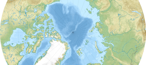
Arctic Ocean
THE ARCTIC is the smallest and shallowest of the Earth's five oceans, occupying 4 percent of the world's ocean space and surrounding the North Pole, the northernmost locale on the planet. The waters of the Arctic are fairly equidistant around the area, making the North Pole the approximate center of the ocean. The majority of […]
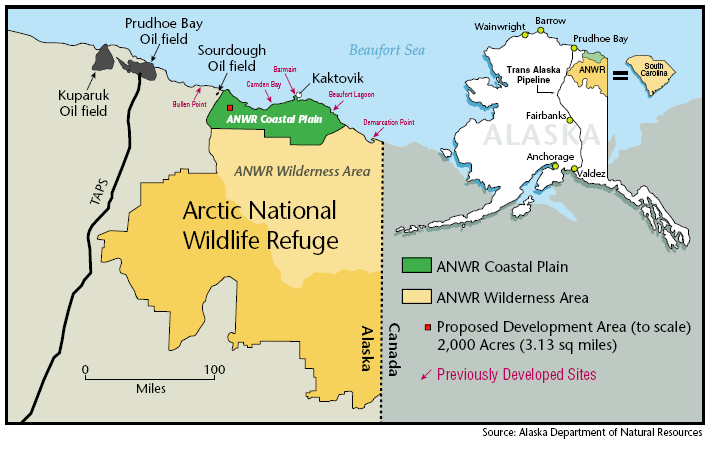
Arctic National Wildlife Refuge
LOCATED IN northeastern ALASKA and managed by the U.S. Fish and Wildlife Service, the Arctic National Wildlife Refuge (ANWR) encompasses the largest diversity of wildlife of any protected area in the circumpolar north, earning it the nickname “the American Serengeti.” Efforts to preserve the refuge began in 1960 with the establishment of the Arctic National Wildlife […]
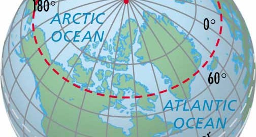
Arctic Circle
LOCATED AT 66.5 degrees north latitude or 23.5 degrees southward of the North Pole, the Arctic Circle forms an imaginary line marking the northernmost location where the sun can be seen during the northern hemisphere's winter solstice (December 21). On June 22 and again on December 21, the circle of illumination (formed by the sun's […]
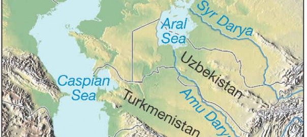
Aral Sea
THE ARAL SEA (Aral'skoye More) is one of the world's largest lakes or inland seas. It is located to the east of the CASPIAN SEA in the Central Asian republics of Kazakhstan and Uzbekistan. The region is arid, with the Karakum Desert lying to the west of the Aral Sea and the Kyzylkum Desert to […]
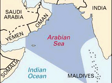
Arabian Sea
THE ARABIAN SEA covers approximately 1,491,000 square mi (3,862,000 square km) and is located between the Arabian and Indian peninsulas in the northwestern area of the INDIAN OCEAN, bounded by INDIA, PAKISTAN, IRAN, OMAN, YEMEN, and the HORN OF AFRICA. The Arabian Sea has been the historic trade route from Occident to Orient since the […]
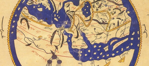
Arab geographers
IN THE MIDDLE AGES, the Arabs, inspired by Mohammed's faith, conquered the FERTILE CRESCENT, North Africa, southern SPAIN, and much of Central Asia, including IRAN and AFGHANISTAN. Arriving from the deserts of Arabia with a rich linguistic tradition but few material possessions, they soon were introduced to the ancient thought of INDIA, Persia, and GREECE. […]
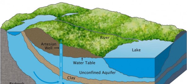
Aquifer
AN AQUIFER IS a subsurface structure or formation that provides a sufficiently permeable condition to yield significant quantities of water to wells and springs. Soil water movement is determined by two factors: porosity, which is the ability to hold on to water particles, and permeability, which is concerned with movement. The word aquifer comes from two […]
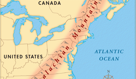
Appalachian Mountains
THE APPALACHIAN Mountains of eastern North America comprise a north to south-tending range that extends for 1,600 mi (2,500 km) from the Gaspe Peninsula in Atlantic Maritime CANADA to northern ALABAMA in the UNITED STATES. Uplifted by the collision of continents ancestral to North America and Africa 270 million years ago, the Appalachian Mountains are the […]
Antipode
DURING THE TIME of Plato and Aristotle (circa 390 B.C.E.), the term antipode was used in reference to a natural balance thought to be sustained by the existence of a continent south of the equator, equal in size to the northern continent. Ptolemy (100–170 C.E.) described this southern landmass as Terra Australis Incognita (unknown southern […]
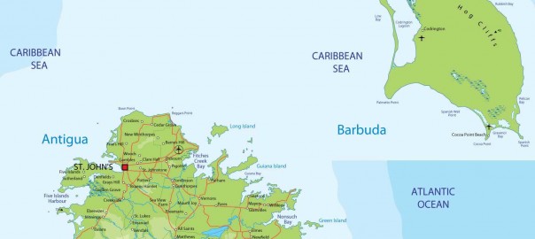
Antigua and Barbuda
Area 173 square mi (443 square km) Capital Saint John's Population 90,900 2014 Highest Point 1,326 ft (402 m) Lowest Point 0 m GDP $1.269 billion 2014 Primary Natural Resources pleasant tropical climate. ANTIGUA WAS ONE of the primary British colonies in the CARIBBEAN SEA and remains a leader among the Leeward Islands (from the […]
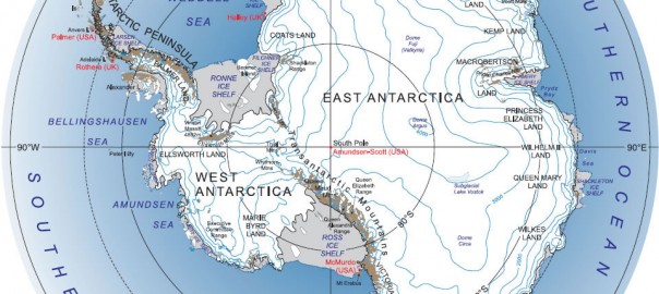
Antarctica
THE WORLD'S fifth-largest continent, Antarctica is home to the South Pole. This continent of almost 98 percent ice and 2 percent barren rock holds the distinction of being the coldest, windiest, driest, and highest continent. Antarctica covers some 5.4 million square mi (14 million square km), and has no indigenous people, but seasonal staff from […]
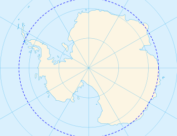
Antarctic Circle
THE ANTARCTIC CIRCLE is an imaginary line located at 66.5 degrees south latitude or 23.5 degrees northward of the South Pole. It marks the southernmost location where the sun can be seen on June 22 (the Southern Hemisphere's winter solstice) and the northernmost location where the midnight sun is visible on December 21 (the Southern Hemisphere's […]
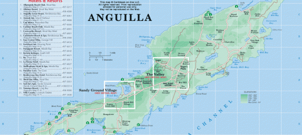
Anguilla
ANGUILLA IS ONE of the smallest and least developed islands in the CARIBBEAN SEA. It was administered as a British colony along with SAINT KITTS AND NEVIS until 1971. Its inhabitants did not wish to remain a dependency of its larger neighbors when they achieved independence in 1983, and Anguilla opted instead to retain its […]
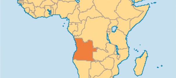
Angola
Area 481,351 square mi (1,246,700 square km) Population 22.14 million 2014 Capital Luanda Highest Point 8,594 ft (2,620 m) Lowest Point 0 m GDP $131.4 billion 2014 Primary Natural Resources petroleum, diamonds, natural gas. A COUNTRY LOCATED along the southwest coast of Africa, the republic of Angola is a vast territory divided into 18 provinces, […]
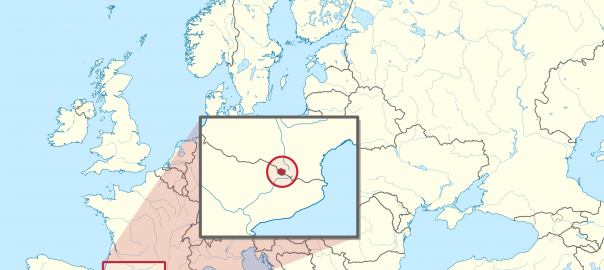
Andorra
Area 183 square mi (468 square km) Capital Andorra la Vella Population 80,150 2014 Highest Point 9,722 ft (2,946 m) Lowest Point 2,772 ft (840 m) GDP $3.249 billion 2013 Primary Natural Resources hydropower, timber. ONE OF THE WORLD'S true curiosities, the sovereign coprincipality of Andorra retains independent status which, according to local history, was […]
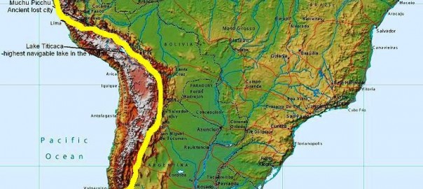
Andes
THE ANDES IS A mountain system in South America. The mountains form the “backbone” of South America, stretching from the Caribbean coast along the western side of the continent to its southern tip. The name Andes probably derives from either Quechua or Aymara, the two principal Native American languages of South America. Plate-tectonic forces during […]
Ancient empires and explorations
SINCE THE BEGINNING of history, human beings have explored the Earth. With the creation of empires, the explorations were often connected to great expeditions made to conquer new territories or to open new commercial roads. The ancient empires and their explorations include the following. EGYPT appeared as a unified state around 3300 B.C.E. About 3100 […]
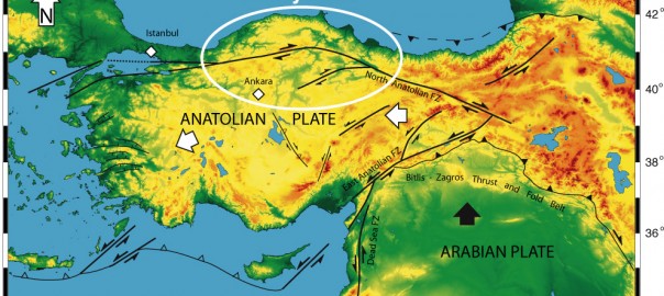
Anatolian Plateau
THE ANATOLIAN PLATEAU is the central upland region of the ancient region of Anatolia, today's TURKEY. The plateau is hemmed in by two parallel mountain ranges, the Taurus to the south, along the Mediterranean coast, and the Pontic Mountains to the north, along the coast of the BLACK SEA. Anatolia has served as a bridge […]
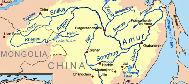
Amur River
THE AMUR RIVER, in Siberia, springs from the confluence of the Shilka and Argun Rivers east of Lake BAIKAL and flows over 1,800 mi (2,897 km) toward the Tatar Straits, the passage between Sakhalin and the Russian Pacific Coast. With all tributaries, the Amur basin covers nearly 750,000 square mi (1,942,491 square km) of area. […]
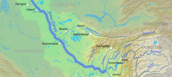
Amu Darya
THE AMU DARYA has served as a bridge between cultures for several millennia. A river that flows straight across one of the harshest deserts in the world, it has served as a natural highway for migrants and invaders from Central Asia to South Asia and the MIDDLE EAST, as well as a boundary for the empires […]
American Samoa
AMERICAN SAMOA, a territory of the UNITED STATES in the PACIFIC OCEAN, consists of the eastern half of the Samoan archipelago and comprises five volcanic islands: the main island of Tutuila and its smaller partner, Anu'u, plus the islands of Ofu, Olosega, and Ta'u (the Manu'a Islands) to the east. The territory, with its capital […]
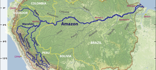
Amazon River
SOME AUTHORITIES believe that the river in BRAZIL and neighboring countries was named after the Amazons, women warriors of Greek mythology, who were thought to reside in the region; other scholars insist that the name is derived from the local native word amassona, meaning “boat destroyer.” Despite centuries of effort to overcome the dominance of nature, […]
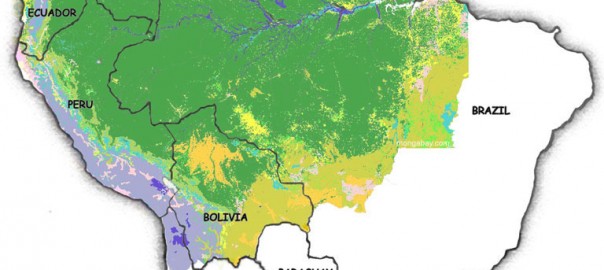
Amazon Rainforest
THE AMAZON RAINFOREST is the largest rainforest in the world. It extends for 3,000 mi (4,828 km) from the ANDES mountains to the ATLANTIC OCEAN. The rainforest covers parts of BRAZIL, PERU, ECUADOR, COLOMBIA, BOLIVIA, and VENEZUELA, encompassing over a billion acres and covering one-third of South America. The 6,500 mi (10,461 km) of the […]
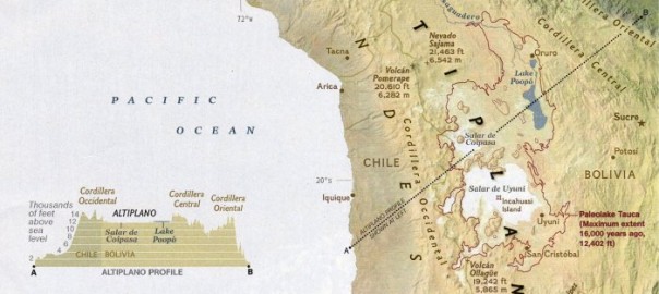
Altiplano
THE ALTIPLANO IS A high plateau located in the central ANDES region of South America at an altitude of about 13,123 ft (4,000 m). It reaches into parts of PERU, BOLIVIA, CHILE, and ARGENTINA. On the west, it bounds the Cordillera Occidental and borders the Cordillera Oriental on the east. It is surrounded by volcanoes […]
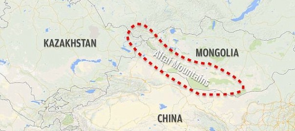
Altai Mountains
THE ALTAI MOUNTAINS are a system of remote mountains in central Asia that cover an area of 326,256 square mi (845,000 square km) bounding RUSSIA, KAZAKHSTAN, MONGOLIA, and CHINA. This system is a natural marvel that has been largely untouched by large industries and has a very sparse population. Its name is derived from the […]
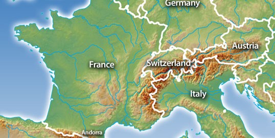
Alps
THE ALPS ARE Europe's major mountain chain, occupying center stage between the ultural and geographic regions of western, eastern, southern, and northern Europe. Stretching in an arc about 600 mi (1,000 km) from west to east, the range covers parts of FRANCE, ITALY, SWITZERLAND, LIECHTENSTEIN, AUSTRIA, and SLOVENIA, with related features extending into GERMANY, CROATIA, and […]
Alluvium
THE SEDIMENT DEPOSITED by rivers is called alluvium. The name derives from the Latin word alluvius, meaning “washed up.” Alluvium comprises clay, silt and sand (in some definitions gravel is included) and derives from the erosion of rocks and soils in the upper reaches of river basins. The mineral characteristics of the alluvium thus reflect […]
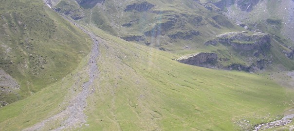
Alluvial fan
THE U.S. COMMITTEE on Alluvial Fan Flooding recently defined an alluvial fan as “a sedimentary deposit located at a topographic break, such as the base of a mountain, escarpment, or valley side, that is composed of streamflow and/or debris flow sediments and that has the shape of a fan either fully or partially extended.” The […]
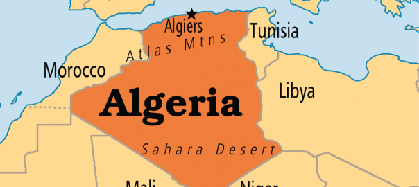
Algeria
Area 919,595 square mi (2,381,740 square km) Population 39.93 million (2014) Capital Algiers Highest Point 9,852 ft (3,003 m) Lowest Point -131 ft (-40 m) GDP $214.1 billion (2014) Primary Natural Resources petroleum and natural gas, mining. WITH MORE THAN 80 percent of its land covered by the SAHARA DESERT in northern Africa, Algeria is […]
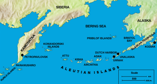
Aleutian Islands
KNOWN AS THE Catherine Archipelago until 1900, the Aleutian Islands comprise some 150 islands in four groups, which are, in order of proximity to the mainland: the Fox, Andreanof, Rat, and Near Islands. The name probably derives from the Chukchi word aliat, meaning “island.” Geographically, the islands separate the Bering Sea from the PACIFIC OCEAN. They extend […]
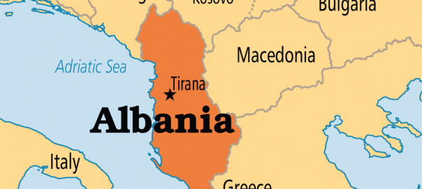
Albania
Area 10,685 square mi (28,748 square km) Capital Tirana Population 2.894 million 2014 Highest Point Maja e Korabit 9,085 ft (2,753 m) Lowest Point 0 m GDP $13.37 billion 2014 Primary Natural Resources petroleum, hydropower. ALBANIA IS UNIQUE in many ways. This small, mountainous nation on the western side of the Balkan Peninsula has a […]
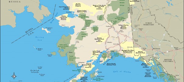
Alaska
THE 49th STATE admitted to the union in U.S. history, Alaska is located northwest of the 48 contiguous states. It borders CANADA to the east, the PACIFIC OCEAN to the south, the Bering Sea to the west, and the ARCTIC OCEAN to the north. Alaska has several distinct physical regions. The southernmost region is named the […]
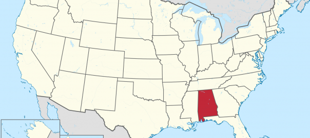
Alabama
THE HEART OF THE Confederate States of America during the Civil War, much of the state of Alabama was originally part of GEORGIA, its eastern neighbor in the south-central UNITED STATES. The British and French fought over the southernmost area until it was ceded to the British in the War of 1812. Scholars disagree on […]
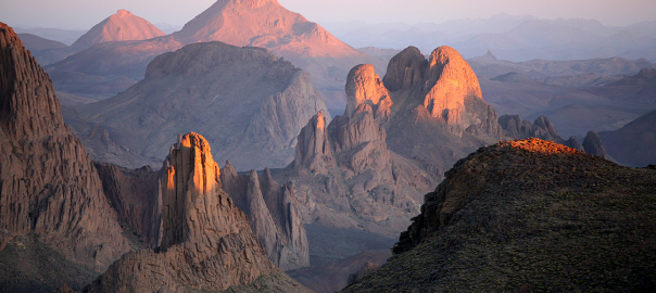
Ahaggar Mountains
THE AHAGGAR IS a large mountainous plateau region lying on the TROPIC OF CANCER in the north-central SAHARA DESERT. It covers an area of 210,000 square mi (543,900 square km) which is about the size of FRANCE, or of ARIZONA and NEW MEXICO combined. It is about 1,000 mi (1,609 km) east of the ATLANTIC […]
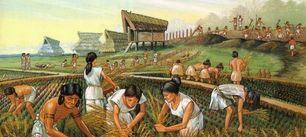
Agricultural Revolution
AROUND 11,000 B.C.E., human beings began to domesticate and cultivate plants. This new activity, which eventually changed populations, lifestyles, and the environment in profound ways, proceeded in sporadic bouts. Although the development of agriculture took place over millennia on different continents, its initial beginning is sometimes referred to as the Agricultural Revolution. Archaeological evidence shows […]
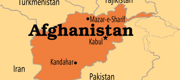
Afghanistan
Area 250,000 square mi (647,500 square km) Population 31.28 million 2014 Capital Kabul Highest Point 24,550 ft (7,485 m) Lowest Point 846 ft (258 m) GDP $20.84 billion 2014 Primary Natural Resources natural gas, petroleum. THE STATE OF AFGHANISTAN is a landlocked country that borders PAKISTAN to the south, IRAN to the west, TURKMENISTAN, UZBEKISTAN, […]
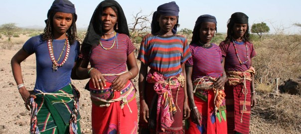
Afars
THE AFAR PEOPLE live in the rocky desert terrain of eastern Africa, in an area called the HORN OF AFRICA. Most of them live in the countries of DJIBOUTI, ETHIOPIA, and ERITREA. The territory, once known as the French Territory of the Afars and Issas, became Djibouti in 1977, when France gave the people their […]
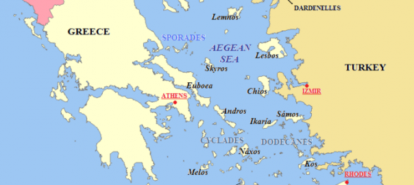
Aegean Sea
THE AEGEAN SEA is an arm of the MEDITERRANEAN SEA, located between the Greek peninsula to the west and TURKEY to the east. The Aegean is connected through the Dardanelles, the Sea of Marmara, and the Bosporus with the BLACK SEA, while the island of Crete is considered to be the southern boundary. In all, it […]
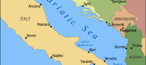
Adriatic Sea
THE ADRIATIC SEA (in Italian “Mar Adriatico,” in Serbian “Jadransko more”) is a northwest-to-southeast arm of the MEDITERRANEAN SEA. The sea separates the Italian peninsula from the Austro-Hungarian, Montenegrin, and Albanian littorals, and the Italian Apennine Mountains from the Balkan Dinaric Alps. The western coast is Italian and the eastern comprises Slovenia, Croatia, Bosnia and […]
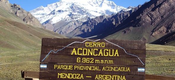
Aconcagua Mountain
ACONCAGUA MOUNTAIN LIES west of Mendoza, argentina, entirely within Argentina, and immediately east of Argentina's border with chile. The mountain is, at 22,834 ft (6,960 m), not only the tallest mountain in the Western Hemisphere, but also the highest outside of Asia. Its twin peaks, the northern of which is the tallest, can be seen […]
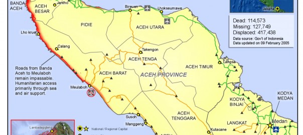
Aceh
ACEH (full name: Naggroe Aceh Darussalam, meaning “the Abode of Peace”) is one of the three “special territories” among the 27 administrative provinces of indonesia. Its location, on the large island of SUMATRA in the northeast corner of the Indonesian archipelago, facing the Andaman Sea and the Straits of Melaka, makes it the closest Indonesian […]
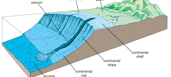
Abyssal plain
LOCATED IN THE world's oceans, an abyssal plain is a depositional surface on the seafloor. The plain is generally 13,000 to 20,000 ft (4,000 to 6,000 m), extending seaward from the base of a continental slope or from the seaward edge of an oceanic trench to the midocean ridge. The term plain implies that this […]
Chronology of Geography
200 million B.C.E. Present-day continents were part of a supercontinent known as Pangaea or Pangea (Greek or “all-Earth”). Over millions of years, this supercontinent broke up through the creation of rifts, cracks in the crust that moved apart and allowed magma to rise from lower levels and form new seabeds. Water moved into the broken landmass […]