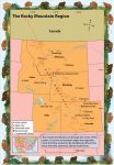
The Rocky Mountain Region
Exploring the Rocky Mountain Region Flying west from the Great Plains, we were greeted by a dramatic sight—a huge wall of tall mountains, stretching from north to south. Our map told us that this was the great range called the Rocky Mountains. The Rockies, as they are called, run from Canada through all of the […]
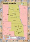
The Great Plains
Exploring the Great Plains From the Midwest, we traveled west to the region known as the Great Plains. This region is located near the center of the United States. It includes the states of Oklahoma, Kansas, Nebraska, South Dakota, and North Dakota. As you know, Admiral, a plain is a flat area without hills or […]
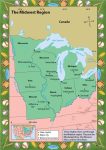
The Midwest
Exploring the Midwest Leaving New Orleans, we followed the Mississippi River north. Hundreds of miles later, we reached another large city. The map said it was St. Louis, in the state of Missouri. Missouri is in the area that Americans call the Midwest. Also part of this region are the states to the north and […]
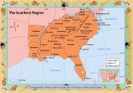
The South
Exploring the South When we left Washington, D.C., Admiral, we did not have to travel far to reach the next region. The South is a large region with interesting cultural diversity as well as striking physical geographical features. Across the landscape there are mountains, rivers, valleys, and sandy beaches. The twelve states that make up […]
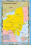
The Mid-Atlantic Region
Exploring the Mid-Atlantic Region As you recall from my last message, Admiral, we were excited because we were on our way from New England to New York City. New York City is in the Mid-Atlantic region of the United States. This region is located near the middle of the Atlantic coastline. It includes five states—New […]
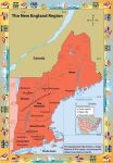
New England
Exploring New England We began our exploration of the United States in the region called New England. This region is in the northeastern part of the United States. It is made up of six states: Maine, New Hampshire, Vermont, Massachusetts, Connecticut, and Rhode Island. The Atlantic Ocean borders all of these states except one—Vermont. In […]
The United States
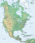
Exploring the United States of America The United States, excluding Alaska and Hawaii, stretches about three thousand miles from coast to coast—or east to west. Because of its great size, it is often divided into smaller geographical areas, or regions. The states in each region have many things in common, such as geography, including climate, […]
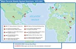
How Do Migrating Anticyclones Form and Affect North America?
ANTICYCLONES ARE ROTATING ZONES of high pressure. Most migrate across Earth's surface, guided by large-scale atmospheric circulation, but some stay or reappear in the same general area year after year. As migrating anticyclones approach, pass over, or leave an area, they cause changes in wind direction, temperature, and moisture. They are typically associated with non-stormy […]
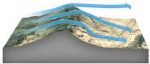
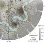
Where Do Mid-Latitude Cyclones Form and Cross North America?
WEATHER FRONTS generally do not exist in isolation, but typically form, migrate, and fade away as part of a larger system called a mid-latitude cyclone. Cold and warm fronts usually trail from a central core of low pressure — a cyclone. While popular culture uses the term “cyclone” to refer to a tornado or other […]
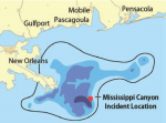
How Did Geographers Help in the 2010 Gulf of Mexico Oil-Spill Cleanup?
ON APRIL 20, 2010, an explosion on the Deepwater Horizon oil rig in the northern Gulf of Mexico killed 11 workers, injured 17 others, and initiated the most disastrous oil spill in U.S. history. For the next 86 days, oil gushed into the Gulf. This oil spill is an example of a complex problem with […]
David Douglas in North America and Hawaii
The Douglas fir (Pseudotsuga menziesii) is a magnificent tree that occurs naturally in western North America from British Columbia southward to northern Mexico. It can grow up to 330 feet (100 m) tall and is one of North America's most valuable sources of timber. The tree can occur in dense stands in forests, but it […]
Chihuahuan Desert: Arizona, Texas, Mexico
The same forces that have shaped the other North American deserts by creating the geologically stretched Basin and Range Province also forged the 280,000-square-mile (450,616 sq km) Chihuahuan Desert. This great desert plain punctuated with a patterned scattering of northsouth trending mountains starts in the shadow of the massive Sierra Madre in Mexico, runs north […]

Sonoran Desert Arizona and Northern Mexico
T he towering, bristling, water-hoarding saguaro cactus cluster thickly across the desert corrugations of Saguaro National Monument in Arizona, brooding over a mystery. The defining plant of the Sonoran Desert, the largest of the saguaro are 200 years old, 50 feet high (15.24 m), and weigh eight tons. They dominate the park that occupies two […]
Weather: The United States
Entire shelves of books have been written about United States weather. In part, that's because the country is both sprawling and populous. The nation's agricultural roots and high mobility also play into its obsession with the atmosphere. But the weather itself deserves some credit. Europeans who settled America from east to west were progressively amazed […]
Weather: Mexico
You'll be hard-pressed to find a blizzard or a tornado in Mexico. Unlike its neighbours to the north, Mexico gets few of the wild temperature swings that play out across the mid-latitudes. Hurricanes are not to be taken lightly in Mexico, however: they can cause major destruction along the east-facing coastlines of the Gulf of […]
Weather: Canada
The worlds second-largest country, Canada has the worlds most extensive coastline, fronting the Atlantic, Pacific and Arctic Oceans. This provides plenty of raw material for a varied climate, much like that of the United States, but colder and drier on average. Storm systems often spin up along the nations southern tier (especially in Alberta) before […]
Weather: North America
North Americas mercurial climate has something for everyone. Severe hurricanes, killer tornadoes, crippling snowstorms, torrential downpours, withering drought and a fair share of nice weather, too – all pay frequent visits to this prosperous, yet vulnerable, land that stretches from the Canadian Arctic to tropical Mexico. Hollywood has bombarded the world with films of extraordinary […]
Canada Looks Ahead
To more clearly see where Canada is going, it is beneficial to remember from where it has come. Its rich history commemorates, celebrates, and teaches valuable lessons not to be forgotten. Canada's identity has been shaped and ornamented by the contributions of diverse peoples. Referred to as a cultural mosaic, millions of Canadians live side […]
Living in Canada Today
Canadians are proud of their diverse heritage and achievements. Its proximity to the United States often means that they are perceived as similar societies, but the two countries do have many differences. Former Prime Minister Pierre Trudeau, highly esteemed by the Canadian public, once stated, “Americans should never underestimate the constant pressure on Canada which […]
Canada: Economy
For seven consecutive years—from 1994 to 2000—Canada held the distinction of being the best country in the world in which to live. The annual ranking by the United Nations assesses such things as life expectancy, adult literacy, and economic prosperity. Canada's life expectancy is 79 years, with a literacy rate of 97 percent. These high […]
Canada: Government
Geographic and cultural diversity offer unique challenges in governing the expansive country of Canada.Dilemmas arise from ongoing issues, such as Quebec's desire for secession, and newer issues, such as the self-governing of Nunavut. Being prepared to meet such challenges responsibly is an ongoing task of the Canadian government. In this chapter, you will read about […]
Canada: Faces and Places
Few people are permanent residents of any one place.Migration (movement from one location to another) occurs for various reasons for various people and involves a host of push-andpull factors. Push-and-pull factors are those reasons why a person feels “pushed” from a present home and “pulled” to the attracting qualities of a different home. Consider factors […]
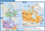
Canada Through Time
The self-governing Dominion of Canada—comprised of Ontario, Quebec, New Brunswick, and Nova Scotia—was established on July 1, 1867. But is this date the real beginning of Canada as a country? At this point in the young country's life, Canada still maintained ties to the British crown. (This unique connection will be further discussed in Chapter […]
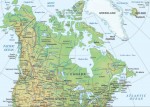
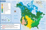
Canada: Physical Landscapes
Canada is a vast country with a great variety of impressive scenery. The natural environment, or physical landscape, provides the stage upon which human cultures play out their ways of living. In this regard, Canada is blessed in countless ways—its land regions, weather and climate, ecosystems, water features, and other natural resources offer much diversity […]
Introducing Canada
Imagine you are hiking on a meandering trail through one of Canada's spectacular national parks. As you breathe in deeply, smelling the natural perfume of the evergreens surrounding you in this particular location, you pause to wonder,“Have I experienced Canada before?” If you have eaten a crisp, juicy McIntosh apple (cultivated in Ontario in 1811 […]
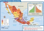
Latin America: Mexico
A HUMAN PERSPECTIVE Quetzalcoatl was a god worshiped by the Toltec and Aztec peoples of Mexico and Central America. According to Native American legend, Quetzalcoatl traveled east across the sea. It was said that he would return some day, bringing peace. One day, messengers brought Montezuma, the Aztec emperor, news that strangers had arrived from […]
CASE STUDY. Diverse Societies Face Change
As you read earlier in this unit, the first immigrants to North America are believed to have come from Asia. They are thought to have crossed a land bridge that existed in what is now the Bering Strait thousands of years ago. Since that time, millions of people from countries all over the world have […]
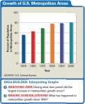
Urban Sprawl
A HUMAN PERSPECTIVE Richard Baron is a real estate developer who tried to address the related problems of urban sprawl and inadequate low-income housing. In 1996, he began building Murphy Park, an affordable and attractive housing complex in mid-town St. Louis, Missouri. The development has more than 400 units and contains both apartments and townhouses. […]
The Fight Against Terrorism
A HUMAN PERSPECTIVE For Karl Co, a 15-year-old sophomore at Stuyvesant High School in New York City, September 11, 2001, began as “such a normal day.” From his classroom, Karl had a clear view of the World Trade Center, just four blocks away. On a normal day, about 50,000 people worked in and 70,000 visited […]
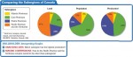
Subregions of Canada
A HUMAN PERSPECTIVE The Grand Banks, a shallow section of the North Atlantic off the coast of Newfoundland, make up one of the earth's richest fishing grounds. In fact, it was the abundance of fish—including cod, haddock, herring, and mackerel—that first attracted Europeans to the region centuries ago. Today, thousands of hardy Canadians make their […]
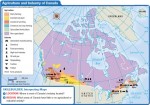
Economy and Culture of Canada
A HUMAN PERSPECTIVE The fur trade was a major economic activity in early Canada. It began in the 16th century, when Canada's Native American peoples, now known as the First Nations, started trading with European fishermen along the northern Atlantic coast. A brisk trade soon developed, and trappers and traders poured into Canada. They came […]
History and Government of Canada
A HUMAN PERSPECTIVE Around A.D. 980, a Viking named Erik the Red sailed to Greenland. Soon after, about 3,000 Vikings colonized the region. About A.D. 1000, Erik's son Leif led an expedition that landed off the Atlantic coast of North America on what is now Newfoundland. Leif called the area Vinland, after the wild grapes […]
Subregions of the United States
A HUMAN PERSPECTIVE America's back roads were the beat of reporter and author Charles Kuralt for more than 20 years. Beginning in the 1960s, he traveled by van through every region of the country. In his “On the Road” series for television, he reported on the uniqueness of the lives of ordinary Americans. He said […]
Economy and Culture of the United States
A HUMAN PERSPECTIVE The average American worker in 1790 was a self-employed farmer. The farmer spent each work day, sunrise to sunset, in backbreaking labor in the field. Most of the crops and livestock raised were consumed by the farm family. In the 1890s, the average American worker labored in a manufacturing or service industry, […]
History and Government of the United States
A HUMAN PERSPECTIVE Women were North America's first farmers. In all early cultures except the hunter-gatherer culture of the Southwest, women cultivated the land. They discovered which wild plants could be used as food for the family. They planted the seeds, tended the garden, harvested the crops, and prepared food for meals. Corn, beans, and […]
The United States and Canada: Human–Environment Interaction
A HUMAN PERSPECTIVE The sun-baked American Southwest was a harsh environment for its early inhabitants, the ancestors of today's Pueblo peoples. But these early settlers made good use of available resources. From the land, they took clay and stone building materials. They built multi-room, apartment-like dwellings in cliffs. This gave protection against daytime heat, nighttime […]
The United States and Canada: Climate and Vegetation
A HUMAN PERSPECTIVE A little gold and bitter cold—that is what thousands of prospectors found in Alaska and the Yukon Territory during the Klondike gold rushes of the 1890s. Most of these fortune hunters were unprepared for the harsh climate and inhospitable land of the far north. Winters were long and cold, the ground frozen. […]
The United States and Canada: Landforms and Resources
A HUMAN PERSPECTIVE The beauty and abundance of the land was a source of wonder to early explorers of North America. One who traveled the Atlantic coast referred to the “amazing extent of uncultivated land, covered with forests, and intermixed with vast lakes and marshes.” A 17th–century French expedition described “a beautiful river, large, broad, […]
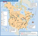
U.S. Possessions
NAVASSA ISLAND Uninhabited island owned by the United States Area: 2 sq. mi. (5.2 sq km) BAKER & HOWLAND ISLANDS Unincorporated territories administered by the U.S. Fish and Wildlife Service as part of the National Wildlife Refuge Official Name: British Indian Ocean Territory Area: 0.5-0.6 sq. mi. (1.40-1.60 sq km), each JARVIS ISLAND Uninhabited territory […]
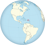
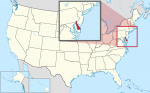
U.S. Virgin Islands
AT A GLANCE Government: Unincorporated; purchased by the United States in 1917 Size: 136 sq. mi. (352 sq km) Population: 102,951 (2016) Electoral votes: 0 U.S. Representatives: 1 (nonvoting) THE PLACE The Virgin Islands are two groups of islands in the Atlantic Ocean, 40 miles (64 km) east of Puerto Rico. They are part of […]
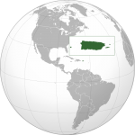
Puerto Rico (USA)
AT A GLANCE Name: Puerto Rico means “rich port” in Spanish. Capital: San Juan Size: 3,515 sq. mi. (9,103 sq km) Population: 3,474,182(2015) Statehood: Unincorporated Electoral votes: 0 U.S. Representatives: 1 (nonvoting) THE PLACE Puerto Rico is an island about 1,000 miles (1,600 km) southeast of Florida, between the United States and South America. Puerto […]
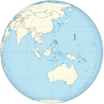
Northern Mariana Islands (USA)
AT A GLANCE Nickname: America's Best Kept Secret Capital: Saipan (38,896) Size: 184 sq. mi. (477 sq km) Population: 53,467 (2016) Statehood: Unincorporated Electoral votes: 0 U.S. Representatives: 1 (nonvoting) THE PLACE The Commonwealth of Northern Mariana Islands is a chain of 16 islands in the Pacific Ocean, south of Japan and east of the […]
Guam (USA)
AT A GLANCE Capital: Hagatna (Agana) Size: 209 sq. mi. (541 sq km) Population: 162,742(2016) Government: Unincorporated territory of United States Electoral votes: 0 U.S. Representatives: 1 (nonvoting) THE PLACE Guam is located in the Pacific Ocean at the southern end of the Mariana Islands. It lies about 1,300 miles (2,100 km) east of the […]
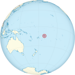
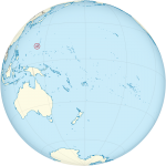
American Samoa (USA)
AT A GLANCE Name: Samoa is a native Polynesian word. Capital: Pago Pago Size: 77 sq. mi. (199 sq km) Population: 54,194 (2016) Statehood: Unincorporated Electoral Votes: 0 U.S. Representatives: 1 (nonvoting) THE PLACE American Samoa is a group of seven islands located about 2,600 miles (4,184 km) southwest of Hawaii. The U.S. federal government […]
District of Columbia
AT A GLANCE Government: The District of Columbia has been the seat of the U.S. government since 1800, and a municipal corporation since February 21, 1871. Area: 68.25 sq. mi. (177 sq km) Population: 672,228 (2015) Electoral votes: 3 U.S. Representatives: 1 (nonvoting) THE PLACE The city of Washington covers the entire District of Columbia, […]
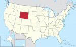
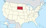
The State of Wyoming
AT A GLANCE Name: Wyoming comes from an Algonquian phrase meaning “large prairie place” or “at the big plain.” Nicknames: Equality State, Cowboy State Capital: Cheyenne Size: 97,818 sq. mi. (253,349 sq km) Population: 586,107 (2015 estimate) Statehood: Wyoming became the 44th state on July 10, 1890. Electoral votes: 3 (2016) U.S. representatives: 1 (until […]
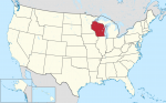
The State of Wisconsin
AT A GLANCE Name: Wisconsin is believed to be taken from one of three possible Indian words—Ouisconsin, Mesconsing, or Wishknosing. The words' meanings are unclear. Nickname: Badger State Capital: Madison Size: 56,145 sq. mi. (145,414 sq km) Population: 5,771,337 (2015 est) Statehood: Wisconsin became the 30th state on May 29, 1848. Electoral votes: 10 (2016) […]
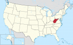
The State of West Virginia
AT A GLANCE Name: West Virginia was once part of Virginia, which was named for England's Queen Elizabeth I. She was known as the Virgin Queen because she never married. Nickname: Mountain State Capital: Charleston Size: 24,231 sq. mi. (62,759 sq km) Population: 1,844,128 (2015 est) Statehood: West Virginia became the 35th state on June […]
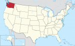
The State of Washington
AT A GLANCE Name: Washington is named after President George Washington Nickname: Evergreen State Capital: Olympia Size: 68,126 sq. mi. (176,446 sq km) Population: 7,170,351 (2015 est) Statehood: Washington became the 42nd state on November 11, 1889. Electoral votes: 11 (2016) U.S. representatives: 9 (until 2016) State tree: western hemlock State flower: western rhododendron State […]
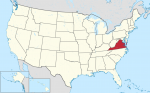
The State of Virginia
AT A GLANCE Name: Virginia was named for Queen Elizabeth I of England, who was known as the Virgin Queen because she never married. Nicknames: Old Dominion, Mother of Presidents Capital: Richmond Size: 40,598 sq. mi. (105,149 sq km) Population: 8,382,993 (2015 est) Statehood: Virginia became the 10th state on June 25, 1788. Electoral votes: […]
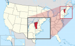
The State of Vermont
AT A GLANCE Name: Vermont is a combination of the French words vert and mont, which mean “green” and “mountain.” Nickname: Green Mountain State Capital: Montpelier Size: 9,615 sq. mi. (24,903 sq km) Population: 626,042 (2015 est) Statehood: Vermont became the 14th state on March 4, 1791. Electoral votes: 3 (2016) U.S. representatives: 1 (until […]
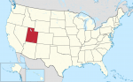
The State of Utah
AT A GLANCE Name: Utah was named for the Ute tribe. Ute means “higher up.” Nickname: Beehive State Capital: Salt Lake City Size: 84,904 sq. mi. (219,902 sq km) Population: 2,995,919 (2015 est) Statehood: Utah became the 45th state on January 4, 1896. Electoral votes: 5 (2016) U.S. representatives: 3 (until 2016) State tree: blue […]
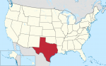
The State of Texas
AT A GLANCE Name: Texas is a Spanish version of a Native American word meaning “friends” or “allies.” Nickname: Lone Star State Capital: Austin Size: 266,874 sq. mi. (691,201 sq km) Population: 27,469,114 (2015 est) Statehood: Texas became the 28th state on December 29, 1845. Electoral votes: 34 (2016) U.S. representatives: 30 (until 2016) State […]
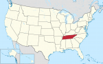
The State of Tennessee
AT A GLANCE Name: The region may have been named after Tanasie, a group of Cherokee villages on the Little Tennessee River. Nickname: Volunteer State Capital: Nashville Size: 42,146 sq. mi. (109,158 sq km) Population: 6,600,299 (2015 est) Statehood: Tennessee became the 16th state on June 1, 1796. Electoral votes: 11 (2016) U.S. representatives: 9 […]
The State of South Dakota
AT A GLANCE Name: Dakota is a Sioux word meaning “friends” or “allies.” Nicknames: Coyote State, Mount Rushmore State Capital: Pierre Size: 77,121 sq. mi. (199744 sq km) Population: 858,469 (2015 est) Statehood: South Dakota became the 40th state on November 2, 1889. Electoral votes: 3 (2016) U.S. representatives: 1 (until 2016) State tree: Black […]
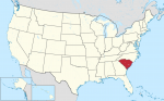
The State of South Carolina
AT A GLANCE Name: South Carolina was named after King Charles I of England. Nickname: Palmetto State Capital: Columbia Size: 31,117 sq. mi. (80,593 sq km) Population: 4,896,146 (2015 est) Statehood: South Carolina became the eighth state on May 23, 1788. Electoral votes: 8 (2016) U.S. representatives: 6 (until 2016) State tree: palmetto State flower: […]
The State of Rhode Island
AT A GLANCE Name: Some historians believe that Rhode Island was named by a Dutch navigator who called it Roode Eylandt (“red island”) because of its red clay. Rhode Island may also have been named for the Greek Isle of Rhodes. Nicknames: Ocean State, Little Rhody Capital: Providence Size: 1,212 sq. mi. (3,142 sq km) […]
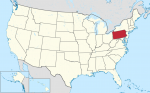
The State of Pennsylvania
AT A GLANCE Name: Pennsylvania was named by King Charles II of England in honor of Admiral Sir William Penn, the father of William Penn, who governed the area. The name means “Penn's woods.” Nickname: Keystone State Capital: Harrisburg Size: 45,310 sq. mi. (117,351 sq km) Population: 12,802,503 (2015 est) Statehood: Pennsylvania became the second […]
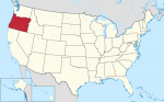
The State of Oregon
AT A GLANCE Name: The exact origin of Oregon's name is unknown, but it may have come from the Native American name for one of the area's rivers—the Ouragon. Nickname: Beaver State Capital: Salem Size: 97,052 sq. mi. (251,365 sq km) Population: 4,028,977 (2015 est.) Statehood: Oregon became the 33rd state on February 14, 1859. […]
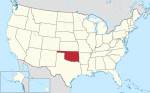
The State of Oklahoma
AT A GLANCE Name: Oklahoma comes from the Choctaw words okla humma, which mean “red people.” Nickname: Sooner State Capital: Oklahoma City Size: 69,903 sq. mi. (181,048 sq km) Population: 3,911,338 (2015 est) Statehood: Oklahoma became the 46th state on November 16, 1907. Electoral votes: 7 (2016) U.S. representatives: 6 (until 2016) State tree: redbud […]
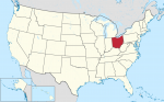
The State of Ohio
AT A GLANCE Name: Ohio is an Iroquois word for “fine or great river.” Nickname: Buckeye State Capital: Columbus Size: 41,330 sq. mi. (107,040 sq km) Population: 11,613,423 (2015 est) Statehood: Ohio became the 17th state on March 1, 1803. Electoral votes: 20 (2016) U.S. representatives: 19 (until 2016) State tree: buckeye State flower: scarlet […]
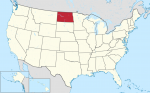
The State of North Dakota
AT A GLANCE Name: Dakota is a Sioux word that means “friends” or “allies.” Nicknames: Sioux State, Flickertail State, Peace Garden State, Rough Rider State Capital: Bismarck Size: 70,704 sq. mi. (13,123 sq km) Population: 756,927 (2015 est) Statehood: North Dakota became the 39th state on November 2, 1889. Electoral votes: 3 (2016) U.S. representatives: […]
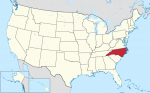
The State of North Carolina
AT A GLANCE Name: North Carolina was named after King Charles I of England. (The Latin word for the name Charles is Carolana.) Nicknames: Tar Heel State, Old North State Capital: Raleigh Size: 52,672 sq. mi. (136,421 sq km) Population: 10,042,802 (2015 est) Statehood: North Carolina became the 12th state on November 21, 1789. Electoral […]
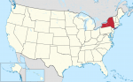
The State of New York
AT A GLANCE Name: New York was named in honor of England's Duke of York. Nickname: Empire State Capital: Albany Size: 49,112 sq. mi. (127,200 sq km) Population: 19,795,791 (2015 est) Statehood: New York became the 11th state on July 26, 1788. Electoral votes: 31 (2016) U.S. representatives: 31 (beginning in 2016) State tree: sugar […]
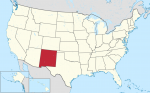
The State of New Mexico
AT A GLANCE Name: New Mexico was named after Mexico by Spanish explorers in the 16th century. Nickname: Land of Enchantment Capital: Santa Fe Size: 121,598 sq. mi. (314,939 sq km) Population: 2,085,109 (2015 est) Statehood: New Mexico became the 47th state on January 6, 1912. Electoral votes: 5 (2016) U.S. representatives: 3 (until 2016) […]
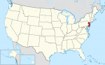
The State of New Jersey
AT A GLANCE Name: New Jersey was named after Jersey, an island in the English Channel. Nickname: Garden State Capital: Trenton Size: 7,790 sq. mi. (20, 175 sq km) Population: 8,958,013 (2015 est) Statehood: New Jersey became the third state on December 18, 1787. Electoral votes: 15 (2016) U.S. representatives: 13 (until 2016) State tree: […]
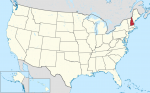
The State of New Hampshire
AT A GLANCE Name: New Hampshire was named for the English county of Hampshire. Nickname: Granite State Capital: Concord Size: 9,283 sq. mi. (24,044 sq km) Population: 1,330,608 (2015 est) Statehood: New Hampshire became the ninth state on June 21, 1788. Electoral votes: 4 (2016) U.S. representatives: 2 (until 2016) State tree: white birch State […]
The State of Nevada
AT A GLANCE Name: Nevada means “snowcapped” in Spanish. Nicknames: Sagebrush State, Silver State Capital: Carson City Size: 110,567 sq. mi. (286,367 sq km) Population: 2,890,845 (2015 est) Statehood: Nevada became the 36th state on October 31, 1864. Electoral votes: 5 (2016) U.S. representatives: 3 State trees: single-leaf pinon and bristlecone pine State flower: sagebrush […]
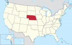
The State of Nebraska
AT A GLANCE Name: Nebraska is from the Oto Indian word nebrathka, meaning “flat water.” Nickname: Cornhusker State Capital: Lincoln Size: 77,358 sq. mi. (200,358 sq km) Population: 1,896,190 (2015 est) Statehood: Nebraska became the 37th state on March 1, 1867. Electoral votes: 5 (2016) U.S. representatives: 3 (until 2016) State tree: cottonwood State flower: […]
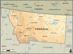
The State of Montana
AT A GLANCE Name: Montana comes from the Spanish word montana, which means “mountainous.” Nicknames: Treasure State, Big Sky Country Capital: Helena Size: 147,046 sq. mi. (380,849 sq km) Population: 1,032,949 (2015 est) Statehood: Montana became the 41st state on November 8, 1889. Electoral votes: 3 (2016) U.S. representatives: 1 (until 2016) State tree: ponderosa […]
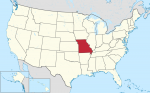
The State of Missouri
AT A GLANCE Name: Missouri is the name of a Native American tribe and means “town with the big canoes.” Nickname: Show Me State Capital: Jefferson City Size: 69,709 sq. mi. (180,546 sq km) Population: 6,083,672 (2015 est.) Statehood: Missouri became the 24th state on August 10, 1821. Electoral votes: 11 (2016) U.S. representatives: 9 […]
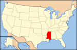
The State of Mississippi
AT A GLANCE Name: Mississippi comes from a Native American word that means “father of waters.” Nickname: Magnolia State Capital: Jackson Size: 47.695 sq. mi. (123,530 sq km) Population: 2,992,333 (2015 est) Statehood: Mississippi became the 20th state on December 10, 1817. Electoral votes: 6 (2016) State representatives: 5 (until 2016) State tree: magnolia State […]
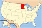
The State of Minnesota
AT A GLANCE Name: Minnesota is from Sioux words that mean “sky-tinted water.” Nicknames: North Star State, Gopher State Capital: St. Paul Size: 84,397 sq. mi. (218,587 sq km) Population: 5,489,594 (2015 est) Statehood: Minnesota became the 32nd state on May 11, 1858. Electoral votes: 10 (2016) U.S. representatives: 8 (until 2016) State tree: red […]
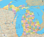
The State of Michigan
AT A GLANCE Name: Michigan comes from a Native American word that means “great or large lake.” Nicknames: Wolverine State, Great Lakes State Capital: Lansing Size: 58,513 sq. mi. (151,548 sq km) Population: 9,922,576 (2015 est) Statehood: Michigan became the 26th state on January 26, 1837. Electoral votes: 17 (2016) U.S. representatives: 16 (until 2016) […]
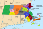
The State of Massachusetts
AT A GLANCE Name: Massachusetts was named for the Massachusett, a Native American tribe whose name means “at or about the great hill.” Nicknames: Bay State, Old Colony State Capital: Boston Size: 8,262 sq. mi. (21,398 sq km) Population: 6,794,422 (2015 est) Statehood: Massachusetts became the sixth state on February 6, 1788. Electoral votes: 12 […]
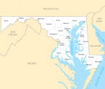
The State of Maryland
AT A GLANCE Name: Maryland was named in honor of Henrietta Maria, queen consort of King Charles I of England. Nicknames: Free State, Old Line State Capital: Annapolis Size: 12,297 sq. mi. (31,972 sq km) Population: 6,006,401 (2015 est) Statehood: Maryland became the seventh state on April 28, 1788. Electoral votes: 10 (2016) U.S. representatives: […]
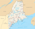
The State of Maine
AT A GLANCE Name: Maine probably comes from the word mainland. Early English explorers used the phrase “the main” to distinguish Maine from its offshore islands. Nickname: Pine Tree State Capital: Augusta Size: 33,265 sq. mi. (87,727 sq km) Population: 1,329,328 (2015 est) Statehood: Maine became the 23rd state on March 15, 1820. Electoral votes: […]
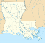
The State of Louisiana
AT A GLANCE Name: Louisiana was named for King Louis XIV of France. Nickname: Pelican State Capital: Baton Rouge Size: 47,751 sq. mi. (124,153 sq km) Population: 4,670,724 (2015) Statehood: Louisiana became the 18th state on April 30, 1812. Electoral votes: 9 (2016) U.S. Representatives: 7 (until 2016) State tree: cypress State flower: magnolia State […]
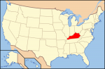
The State of Kentucky
AT A GLANCE Name: Kentucky is from the Iroquois word Ken-tah-ten, which means “land of tomorrow.” Nickname: Bluegrass State Capital: Frankfort Size: 40,411 sq. mi. (104,665 sq km) Population: 4,425,092 (2015 est) Statehood: Kentucky became the 15th state on June 1, 1792. Electoral votes: 8 (2016) U.S. Representatives: 6 (until 2016) State tree: tulip poplar […]
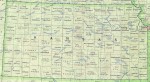
The State of Kansas
AT A GLANCE Name: Kansas is from a Sioux word meaning “people of the south wind.” Nickname: Sunflower State, Jayhawker State Capital: Topeka Size: 82,282 sq. mi. (213,110 sq km) Population: 2,911,641 (2015 est) Statehood: Kansas became the 34th state on January 29, 1861. Electoral votes: 6 (2016) U.S. Representatives: 4 (until 2016) State tree: […]
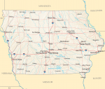
The State of Iowa
AT A GLANCE Name: Iowa is believed to have come from a Native American word meaning “this is the place” or “the beautiful land.” Nickname: Hawkeye State Capital: Des Moines Size: 56,276 sq. mi. (145,755 sq km) Population: 3,123,899 (2015 est) Statehood: Iowa became the 29th state on December 28, 1846. Electoral votes: 7 (2016) […]
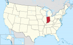
The State of Indiana
AT A GLANCE Name: Indiana means “land of Indians.” Nickname: Hoosier State Capital: Indianapolis Size: 36,420 sq. mi. (94,328 sq km) Population: 6,619,680 (2015 est) Statehood: Indiana became the 19th state on December 11, 1816. Electoral votes: 11 (2016) U.S. Representatives: 10 (until 2016) State tree: tulip poplar State flower: peony State bird: cardinal Highest […]
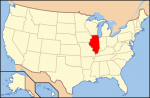
The State of Illinois
AT A GLANCE Name: Illinois is an Algonquian word meaning “tribe of superior men.” Nickname: Prairie State Capital: Springfield Size: 57,918 sq. mi. (150,007 sq km) Population: 12,859,995 (2015 est) Statehood: Illinois became the 21st state on December 3, 1818. Electoral votes: 21 (2016) U.S. Representatives: 20 (until 2016) State tree: white oak State flower: […]
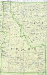
The State of Idaho
AT A GLANCE Name: The meaning of the name Idaho is unknown, although it is believed to be of Native American origin. Nickname: Gem State Capital: Boise Size: 83,574 sq. mi. (217,292 sq km) Population: 1,654,930 (2015 est) Statehood: Idaho became the 43rd state on July 3, 1890. Electoral votes: 4 (2016) U.S. Representatives: 2 […]
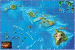
The State of Hawaii
AT A GLANCE Name: The origin of the name Hawaii is uncertain. The islands may have been named after Hawaii Loa, the chief who has traditionally been believed to have discovered them, or they may have been named after Hawaii or Hawaiki, the traditional home of the Polynesians. Nickname: Aloha State Capital: Honolulu Size: 6,459 […]
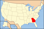
The State of Georgia
AT A GLANCE Name: Georgia was named for King George II of England. Nicknames: Peach State, Empire State of the South Capital: Atlanta Size: 58,977 sq. mi. Population: 10,214,860 (2015 est) Statehood: Georgia became the fourth state on January 2, 1788. Electoral votes: 15 (2016) U.S. Representatives: 11 (until 2016) State tree: live oak State […]
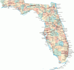
The State of Florida
AT A GLANCE Name: Spanish explorer Ponce de Leon named Florida when he landed there on Easter Sunday in 1513. He called the place Pascua Florida, which means “flowery Easter” in Spanish. Nickname: Sunshine State Capital: Tallahassee Size: 59,928 sq. mi. Population: 20,271,272 (2015 est) Statehood: Florida became the 27th state on March 3, 1845. […]
The State of Delaware
AT A GLANCE Name: The name Delaware comes from the Delaware River and Bay, which were named for Sir Thomas West, Baron De La Warr, the first governor of Virginia. Nicknames: First State, Diamond State Capital: Dover Size: 2,396 sq. mi. Population: 935 614 (2014) Statehood: Delaware became the first state on December 7, 1787. Electoral […]

The State of Connecticut
AT A GLANCE Name: Connecticut comes from an Algonquian word meaning “place beside the long tidal river.” Nicknames: Constitution State, Nutmeg State Capital: Hartford Size: 5,544 sq. mi. Population: 3,597,000 (2014) Statehood: Connecticut became the fifth state on January 9, 1788. Electoral votes: 7 (2016) U.S. Representatives: 6 (until 2016) State tree: white oak State […]
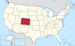
The State of Colorado
AT A GLANCE Name: Colorado is a Spanish word that means “colored red.” The name was first given to the Colorado River by Spanish explorers because it flows through red stone canyons. Nickname: Centennial State Capital: Denver Size: 104,100 sq. mi. Population: 5,356,000 (2014) Statehood: Colorado became the 38th state on August 1, 1876. Electoral […]
The State of California
AT A GLANCE Name: California is named after Califia, a mythical island paradise described by Garci Ordonez de Montalvo in his 16th-century novel Las Sergas de Esplandian. Nickname: Golden State Capital: Sacramento Size: 158,869 sq. mi. Population: 39,144,818 (2015 est) Statehood: California became the 31st state on September 9, 1850. Electoral votes: 55 (2016) U.S. […]
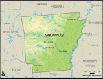
The State of Arkansas
AT A GLANCE Name: The word Arkansas is from the French name for the Quapaw tribe, the Arkansa, and the region the tribe inhabited. Nicknames: Natural State, Razorback State, Land of Opportunity Capital: Little Rock Size: 53,182 sq. mi. Population: 2,966,000 (2014) Statehood: Arkansas became the 25th state on June 15, 1836. Electoral votes: 6 […]
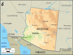
The State of Arizona
AT A GLANCE Name: Arizona comes from the Native American word Arizonac, which means “little spring” or “young spring.” Nickname: Grand Canyon State Capital: Phoenix Size: 114,006 sq. mi. Population: 6,731,000 (2014) Statehood: Arizona became the 48th state on February 14, 1912. Electoral votes: 11 (2016) U.S. Representatives: 9 (until 2003) State tree: paloverde State flower: saguaro […]
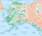
The State of Alaska
AT A GLANCE Name: Alaska comes from an Aleut word meaning “great land.” Nicknames: Last Frontier, Land of the Midnight Sun Capital: Juneau Size: 615,230 sq. mi. Population: 736 732 (2014) Statehood: Alaska became the 49th state on January 3, 1959. Electoral votes: 3 (2016) U.S. Representatives: 1 (until 2016) State tree: Sitka spruce State flower: forget-me-not State […]
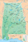
The State of Alabama
AT A GLANCE Name: Alabama comes from the word Alibamu, the name of a Native American tribe that lived in the area. The name may mean “to clear the vegetation.” Nicknames: Heart of Dixie, Camellia State, Yellowhammer State Capital: Montgomery Size: 52,237 sq. mi. Population: 4,849,000 (2014) Statehood: Alabama became the 22nd state on December 14, 1819. Electoral […]
The United States Looks Ahead
Now is but a minute blip on the span of time. It is the product of countless past processes and events. By looking to the past, we can better understand the present, and the past also provides keys to predicting the future. This chapter attempts to answer a very difficult question: What does the future hold for the United […]
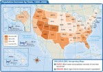
Living in the United States Today
For the majority of Americans, life is good. Few countries can match the level of health care, longevity, income, or educational attainment enjoyed by American citizens. The same can be said for the nation's transportation and communications infrastructure, services, and many other developments that Americans often take for granted. In 2006, the United States ranked eighth among the world's countries in […]
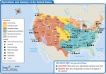
The United States’ Economy
With an annual gross national product (GNP) of about $13 trillion in 2006, the United States is the world's largest and most powerful economy by a wide margin. By any measure, the country is an economic giant. In fact, it is responsible for about 30 percent of all of the world's economic production and services! To place the country's economic […]
Government and Politics
Epluribus unum is perhaps the best-known motto of the United States of America. Translated from Latin, it means “From many, one,” or “Out of many, one.” In working to achieve this goal, the nation's Founding Fathers and subsequent leaders faced a challenge of herculean dimensions. You have already learned that, from the very beginning, this land has been home to […]
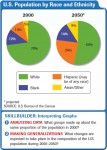
People and Culture
These lines, part of a poem written by Emma Lazarus, appear on the Statue of Liberty. They offer a very appropriate introduction to this chapter on the American population. The United States has been and continues to be a grand human experiment conducted on a colossal scale. It has often been called a “country of immigrants,” people who arrived from […]