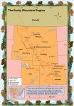
The Rocky Mountain Region
Exploring the Rocky Mountain Region Flying west from the Great Plains, we were greeted by a dramatic sight—a huge wall of tall mountains, stretching from north to south. Our map told us that this was the great range called the Rocky Mountains. The Rockies, as they are called, run from Canada through all of the […]
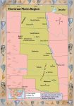
The Great Plains
Exploring the Great Plains From the Midwest, we traveled west to the region known as the Great Plains. This region is located near the center of the United States. It includes the states of Oklahoma, Kansas, Nebraska, South Dakota, and North Dakota. As you know, Admiral, a plain is a flat area without hills or […]
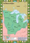
The Midwest
Exploring the Midwest Leaving New Orleans, we followed the Mississippi River north. Hundreds of miles later, we reached another large city. The map said it was St. Louis, in the state of Missouri. Missouri is in the area that Americans call the Midwest. Also part of this region are the states to the north and […]
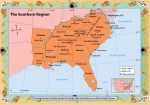
The South
Exploring the South When we left Washington, D.C., Admiral, we did not have to travel far to reach the next region. The South is a large region with interesting cultural diversity as well as striking physical geographical features. Across the landscape there are mountains, rivers, valleys, and sandy beaches. The twelve states that make up […]
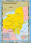
The Mid-Atlantic Region
Exploring the Mid-Atlantic Region As you recall from my last message, Admiral, we were excited because we were on our way from New England to New York City. New York City is in the Mid-Atlantic region of the United States. This region is located near the middle of the Atlantic coastline. It includes five states—New […]
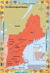
New England
Exploring New England We began our exploration of the United States in the region called New England. This region is in the northeastern part of the United States. It is made up of six states: Maine, New Hampshire, Vermont, Massachusetts, Connecticut, and Rhode Island. The Atlantic Ocean borders all of these states except one—Vermont. In […]
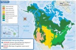
The United States
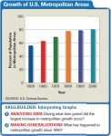
Exploring the United States of America The United States, excluding Alaska and Hawaii, stretches about three thousand miles from coast to coast—or east to west. Because of its great size, it is often divided into smaller geographical areas, or regions. The states in each region have many things in common, such as geography, including climate, […]
What Influences Climates Near the Southern Isthmus of Central America?
THE SOUTHERN ISTHMUS OF CENTRAL AMERICA is geographically and climatically one of the most interesting places in the world. It is a narrow strip of land that connects Central America and South America and that separates very different waters of the Pacific and Atlantic Oceans. The climate of the region reflects intricately changing wind patterns […]
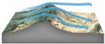
How Do Migrating Anticyclones Form and Affect North America?
ANTICYCLONES ARE ROTATING ZONES of high pressure. Most migrate across Earth's surface, guided by large-scale atmospheric circulation, but some stay or reappear in the same general area year after year. As migrating anticyclones approach, pass over, or leave an area, they cause changes in wind direction, temperature, and moisture. They are typically associated with non-stormy […]
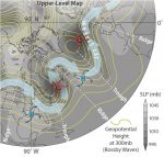
Where Do Mid-Latitude Cyclones Form and Cross North America?
WEATHER FRONTS generally do not exist in isolation, but typically form, migrate, and fade away as part of a larger system called a mid-latitude cyclone. Cold and warm fronts usually trail from a central core of low pressure — a cyclone. While popular culture uses the term “cyclone” to refer to a tornado or other […]
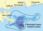
How Did Geographers Help in the 2010 Gulf of Mexico Oil-Spill Cleanup?
ON APRIL 20, 2010, an explosion on the Deepwater Horizon oil rig in the northern Gulf of Mexico killed 11 workers, injured 17 others, and initiated the most disastrous oil spill in U.S. history. For the next 86 days, oil gushed into the Gulf. This oil spill is an example of a complex problem with […]
Jamaica Looks to the Future
As a young nation, Jamaica has experienced a fair measure of inconsistency in its economic and political management. The country faces several major challenges to further development. A stagnating economy, currently beset by a variety of financial crises, must be jump-started. The island's fragile, but economically critical natural resource base must be protected. Prospects for […]
Living in Jamaica Today
Jamaicans are modern people, and their life is not that different from that in the United States. They dress much like Americans, wearing Nikes, T-shirts, and jeans; watch television; listen to music; and go to movies. British influence is evident in sports and education. Today, popular culture, although uniquely Jamaican, is more often developed on […]
Economy
Jamaica is classified as a less developed country (LDC), as is true of countries throughout the Caribbean and elsewhere in Latin America. The nation faces many problems that hinder economic growth. It also has many advantages that, if properly developed, can boost development. IS JAMAICA A WEALTHY COUNTRY? Gross domestic product (GDP) is one of […]
Administration and Government
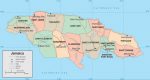
Jamaica is a democratic country but one beset with many problems. This chapter describes and explains the country's governance, its divisions, and the problems it faces in serving its people. COUNTIES AND PARISHES Jamaica is divided into three counties, each of which is further divided into parishes. In the mid-nineteenth century, Jamaica had a total […]
People and Culture
POPULATION TRENDS Size of population is an important characteristic of any country. It determines the number of houses, schools, and hospitals; the size of the labor force; and the amount of food and water it is likely to need. The total population of Jamaica in July 2003 was an estimated 2.7 million, with an annual […]
History
Jamaica has a remarkable and dramatic history, one of merging peoples and cultures. The island's inhabitants enjoy a culture that is a blend of traditions from various groups that have come to the island over time. They include the native Taino Indians, the English colonizers, and Africans who were introduced to the Caribbean to perform […]
Natural Environment
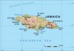
Jamaica has a rich and varied natural environment. The island's land features range from low-lying coastal plains to the Blue Mountain crests reaching nearly 7,500 feet (2,286 meters) in elevation. Part of the island is a lush tropical paradise, and some areas are dry much of the year making them almost desertlike in appearance and […]
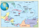
Introducing Jamaica
On a blustery January day, would you like to be on a tropical island? Come to Jamaica, a country of sun-drenched beaches, warm tropical breezes, and a rich cultural heritage. Jamaica is an island nation and a close neighbor of the United States. It is a masterpiece of tropical splendor and extraordinary vistas. The natural […]
Chile Looks Ahead
Pablo Neruda, Chile's national poet, wrote this poem to express his belief in the spiritual strength of the Chilean people. The nighttime is the darkness of Chile's uncertain future. The guitar is the land. The Chilean people are the dawn; they have the power and energy to strum the guitar, awaken the darkness, and reveal […]
Living in Chile Today
URBAN LIVING Nearly all Chileans live in cities. The typical Chilean city has traditional-style, adobe buildings and quaint plazas in the older sections. Modern-style offices and other buildings are scattered along major streets. The tallest buildings hardly reach four or five stories in most cities. The suburbs range from hastily built callampa (mushroom in Chilean speech) […]
Economy
Chile has one the world's best performing economies. A measure of a country's economic performance is the Gross Domestic Product (GDP). The GDP is the value of all goods and services produced by a country. From 1990 to 2000, Chile's GDP grew 5.2 percent annually. This was the highest rate of GDP growth among all […]
Government and Politics
hile has a democratic government that allows every adult the right to vote. Its laws apply to everyone. Its citizens have the right to receive fair trials, and they can meet and discuss freely their political and religious beliefs. As a democratic government, the nation educates its citizens, which enables them to make informed decisions […]
People and Culture
Geography and history formed the crucible from which Chile was born. In the twentieth century, the country survived dictatorships and social upheavals to become a model of democracy in Latin America. Today, the vitality of its people and culture heighten the world's respect for this small nation even more. POPULATION Chile's 15.7 million people are […]
Chile Through Time
Chile's remote location has influenced much of its history. Indigenous peoples of the area lived on the distant fringe of the Inca civilization. Stretching from what is now Ecuador to middle Chile, the Inca Empire preceded the Spanish Empire in the Andes region. The Incas conquered Chile's northern natives and most of the natives occupying […]
Physical Landscapes
Three major landform regions divide Chile: the Andes Mountains, the coast and islands, and the Central Valley. The regions run north to south and parallel to each other. The Andes region is an awesome mountain barrier. Its majestic peaks of spectacular height and bone-chilling temperatures define the country's eastern border. The nation's coast includes imposing […]
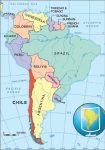
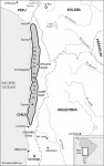
Chile: Introduction
Chile has a little of everything. It is rich in copper, fruits, forests, and fish. It is a country of dramatic scenery and many climates. Cool waters stroke its shore and icy glaciers crown its peaks. Sighs of volcanoes and jolts of earthquakes shake its ribs. Squeezed between the heights of the mountains and the […]
Carl Skottsberg and the Plants of Southern South America
At Punta Arenas, in southern Chile, there is a botanical garden named in honor of one of the world's greatest botanical explorers. The Jardin Botanico “Carl Skottsberg” was founded in 1970, just a few years after the death of the Swedish botanist Carl Skottsberg (1880–1963). Early in his career, Skottsberg took part in a Swedish […]

Alexander von Humboldt and the Plants of South America
Alexander von Humboldt's exploration of South America, accompanied by the French botanist Aime Bonpland (1773–1858), did much to establish biogeography as a distinct scientific discipline, but Humboldt was much more than a geographer. In his most famous work, Kosmos, published in five volumes between 1845 and 1862, he wrote that “I always wanted . . […]
David Douglas in North America and Hawaii
The Douglas fir (Pseudotsuga menziesii) is a magnificent tree that occurs naturally in western North America from British Columbia southward to northern Mexico. It can grow up to 330 feet (100 m) tall and is one of North America's most valuable sources of timber. The tree can occur in dense stands in forests, but it […]
Atacama: The Oldest Desert: South America
T he ancient, cold Atacama Desert might as well be on another planet. In fact, when scientists wanted to find a place harsh enough to test the robots they planned to send to Mars to look for the faintest, most beleaguered traces of life, they came first to this 700-mile-long (1,100 km) desert in northern […]
Chihuahuan Desert: Arizona, Texas, Mexico
The same forces that have shaped the other North American deserts by creating the geologically stretched Basin and Range Province also forged the 280,000-square-mile (450,616 sq km) Chihuahuan Desert. This great desert plain punctuated with a patterned scattering of northsouth trending mountains starts in the shadow of the massive Sierra Madre in Mexico, runs north […]

Sonoran Desert Arizona and Northern Mexico
T he towering, bristling, water-hoarding saguaro cactus cluster thickly across the desert corrugations of Saguaro National Monument in Arizona, brooding over a mystery. The defining plant of the Sonoran Desert, the largest of the saguaro are 200 years old, 50 feet high (15.24 m), and weigh eight tons. They dominate the park that occupies two […]
Weather: Chile
This is the world's most linear country: Chile spans 38° of latitude but less than 2° of longitude at its narrowest point. All along that length, the Andes and the Pacific face off. This means the gradual transition from sub-tropic to sub-polar along Chile's length is rivalled by the changes that occur in a short […]
Weather: South America
Bone-dry deserts overlooking tropical oceans, perpetual windswept chill, hushed tropical splendour – South America isn't lacking in climatic variety. As opposed to the chameleon-like seasonal shifts found in Asia and North America, South America specializes in more-uniform climates that maintain their bold, distinctive hues throughout the year. Despite the “South” in its name, a good […]
Weather: Central America
On a global scale, Central America might seem to be little more than a thread of land connecting the much larger fabrics of North and South America. Yet clinging to this thread is a spectacular array of landforms, cultures and micro-climates. As you'd expect for a region lying wholly between the Tropic of Cancer and […]
Weather: The United States
Entire shelves of books have been written about United States weather. In part, that's because the country is both sprawling and populous. The nation's agricultural roots and high mobility also play into its obsession with the atmosphere. But the weather itself deserves some credit. Europeans who settled America from east to west were progressively amazed […]
The great American thermometer race
Roadside kitsch is a US tradition and the country's oversized weather extremes are a natural source of material. At least two tornado “museums” sprang up during the 1990s, for instance. On your way to Death Valley, California – the hottest spot in the Americas – it's difficult to miss the world's largest thermometer display. Erected […]
Weather: Mexico
You'll be hard-pressed to find a blizzard or a tornado in Mexico. Unlike its neighbours to the north, Mexico gets few of the wild temperature swings that play out across the mid-latitudes. Hurricanes are not to be taken lightly in Mexico, however: they can cause major destruction along the east-facing coastlines of the Gulf of […]
Weather: Canada
The worlds second-largest country, Canada has the worlds most extensive coastline, fronting the Atlantic, Pacific and Arctic Oceans. This provides plenty of raw material for a varied climate, much like that of the United States, but colder and drier on average. Storm systems often spin up along the nations southern tier (especially in Alberta) before […]
Weather: North America
North Americas mercurial climate has something for everyone. Severe hurricanes, killer tornadoes, crippling snowstorms, torrential downpours, withering drought and a fair share of nice weather, too – all pay frequent visits to this prosperous, yet vulnerable, land that stretches from the Canadian Arctic to tropical Mexico. Hollywood has bombarded the world with films of extraordinary […]
South America’s stray hurricane
People in Brazil aren't used to hurricanes, to put it mildly. In fact, no hurricane had ever been reported there until 28 March 2004, when a mysterious system packing winds up to 137 km/hr (85 mph) swept onto the coast of Santa Catarina province. Forecasters from Brazil and from the US National Hurricane Centre had […]
Canada Looks Ahead
To more clearly see where Canada is going, it is beneficial to remember from where it has come. Its rich history commemorates, celebrates, and teaches valuable lessons not to be forgotten. Canada's identity has been shaped and ornamented by the contributions of diverse peoples. Referred to as a cultural mosaic, millions of Canadians live side […]
Living in Canada Today
Canadians are proud of their diverse heritage and achievements. Its proximity to the United States often means that they are perceived as similar societies, but the two countries do have many differences. Former Prime Minister Pierre Trudeau, highly esteemed by the Canadian public, once stated, “Americans should never underestimate the constant pressure on Canada which […]
Canada: Economy
For seven consecutive years—from 1994 to 2000—Canada held the distinction of being the best country in the world in which to live. The annual ranking by the United Nations assesses such things as life expectancy, adult literacy, and economic prosperity. Canada's life expectancy is 79 years, with a literacy rate of 97 percent. These high […]
Canada: Government
Geographic and cultural diversity offer unique challenges in governing the expansive country of Canada.Dilemmas arise from ongoing issues, such as Quebec's desire for secession, and newer issues, such as the self-governing of Nunavut. Being prepared to meet such challenges responsibly is an ongoing task of the Canadian government. In this chapter, you will read about […]
Canada: Faces and Places
Few people are permanent residents of any one place.Migration (movement from one location to another) occurs for various reasons for various people and involves a host of push-andpull factors. Push-and-pull factors are those reasons why a person feels “pushed” from a present home and “pulled” to the attracting qualities of a different home. Consider factors […]
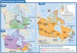
Canada Through Time
The self-governing Dominion of Canada—comprised of Ontario, Quebec, New Brunswick, and Nova Scotia—was established on July 1, 1867. But is this date the real beginning of Canada as a country? At this point in the young country's life, Canada still maintained ties to the British crown. (This unique connection will be further discussed in Chapter […]
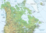
Canada: Physical Landscapes
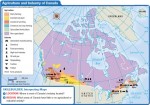
Canada is a vast country with a great variety of impressive scenery. The natural environment, or physical landscape, provides the stage upon which human cultures play out their ways of living. In this regard, Canada is blessed in countless ways—its land regions, weather and climate, ecosystems, water features, and other natural resources offer much diversity […]
Introducing Canada
Imagine you are hiking on a meandering trail through one of Canada's spectacular national parks. As you breathe in deeply, smelling the natural perfume of the evergreens surrounding you in this particular location, you pause to wonder,“Have I experienced Canada before?” If you have eaten a crisp, juicy McIntosh apple (cultivated in Ontario in 1811 […]
Latin America: The Income Gap
A long the oceanfront in Rio de Janeiro, Brazil, gleaming office buildings and hotels share the boulevards with trendy restaurants and exclusive shops. Behind all this glitter and glamour, however, is another world, hidden from sight—the favelas, or slums, of Rio. Here, the poor live among swamps and garbage dumps, and on barren hillsides. These […]
Latin America: Giving Citizens a Voice
A HUMAN PERSPECTIVE From the late 1970s through the early 1980s, the Argentine military waged a campaign of terror against those who supported political reform. As many as 30,000 people mysteriously disappeared. People accused of being terrorists and revolutionaries were kidnapped and questioned. Some were tortured, and then killed or “disappeared”— their bodies were never […]
Latin America: Rain Forest Resources
A HUMAN PERSPECTIVE In 1997, biologist Marc van Roosmalen made an incredible discovery. An Amazonian Indian had brought the biologist a tiny monkey huddled inside a tin can. Van Roosmalen realized that the monkey was a kind of pygmy marmoset never before seen by scientists. Over the next three years, Van Roosmalen and his colleagues […]
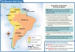
Latin America: Brazil
A HUMAN PERSPECTIVE In 1807, Napoleon's armies invaded Portugal. As the French army approached the capital of Lisbon, the Portuguese royal family boarded ships to escape capture. They sailed to Brazil, Portugal's largest colony, taking their court and royal treasury with them. For the next 14 years, Brazil was the heart of the Portuguese empire. […]
Spanish-Speaking South America
A HUMAN PERSPECTIVE In the early 1500s, the Inca empire was at the height of its glory. Then Spanish soldiers under the command of Francisco Pizarro invaded the South American empire. The Spanish attacked the Inca army, killed many of its warriors, and took the emperor prisoner. The Spaniards held him for ransom. Although the […]
Latin America: Central America and the Caribbean
A HUMAN PERSPECTIVE Central America forms an isthmus, a land bridge between North and South America. It also divides two oceans. This geographic fact has made the region attractive to the United States and other major world powers and has helped to keep the area fragmented and politically unstable. For example, in the early 20th […]
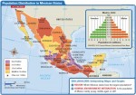
Latin America: Mexico
A HUMAN PERSPECTIVE Quetzalcoatl was a god worshiped by the Toltec and Aztec peoples of Mexico and Central America. According to Native American legend, Quetzalcoatl traveled east across the sea. It was said that he would return some day, bringing peace. One day, messengers brought Montezuma, the Aztec emperor, news that strangers had arrived from […]
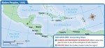
Latin America: Human–Environment Interaction
A HUMAN PERSPECTIVE High in the Andes Mountains, in what is present-day Peru, the ancient Inca needed fields in which to grow crops. By the 1200s, in the highlands around their capital of Cuzco and elsewhere, the Inca carved terraces out of the steep sides of the Andes Mountains. They built irrigation channels to bring […]
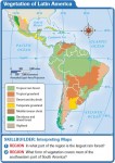
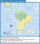
Latin America: Climate and Vegetation
A HUMAN PERSPECTIVE In the 17th century, missionaries and Indians in the area of present-day Paraguay were at times attacked by jaguars, the great cats of Latin America. In 1637, packs of jaguars roamed the countryside, attacking humans. The Indians built barricades for protection from the savage cats. But the jaguars remained a source of […]
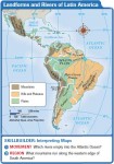
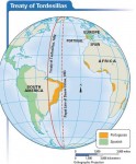
Latin America: Landforms and Resources
A HUMAN PERSPECTIVE Simon Bolivar was a general who led the South American wars of independence against Spain. In August 1819, Bolivar led approximately 2,500 soldiers on a daring march from Venezuela over the mountains into present-day Colombia. Coming from this direction, over the massive barrier of the Andes Mountains, Bolivar and his troops were […]
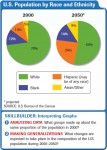
CASE STUDY. Diverse Societies Face Change
As you read earlier in this unit, the first immigrants to North America are believed to have come from Asia. They are thought to have crossed a land bridge that existed in what is now the Bering Strait thousands of years ago. Since that time, millions of people from countries all over the world have […]
Urban Sprawl
A HUMAN PERSPECTIVE Richard Baron is a real estate developer who tried to address the related problems of urban sprawl and inadequate low-income housing. In 1996, he began building Murphy Park, an affordable and attractive housing complex in mid-town St. Louis, Missouri. The development has more than 400 units and contains both apartments and townhouses. […]
The Fight Against Terrorism
A HUMAN PERSPECTIVE For Karl Co, a 15-year-old sophomore at Stuyvesant High School in New York City, September 11, 2001, began as “such a normal day.” From his classroom, Karl had a clear view of the World Trade Center, just four blocks away. On a normal day, about 50,000 people worked in and 70,000 visited […]
Subregions of Canada
A HUMAN PERSPECTIVE The Grand Banks, a shallow section of the North Atlantic off the coast of Newfoundland, make up one of the earth's richest fishing grounds. In fact, it was the abundance of fish—including cod, haddock, herring, and mackerel—that first attracted Europeans to the region centuries ago. Today, thousands of hardy Canadians make their […]
Economy and Culture of Canada
A HUMAN PERSPECTIVE The fur trade was a major economic activity in early Canada. It began in the 16th century, when Canada's Native American peoples, now known as the First Nations, started trading with European fishermen along the northern Atlantic coast. A brisk trade soon developed, and trappers and traders poured into Canada. They came […]
History and Government of Canada
A HUMAN PERSPECTIVE Around A.D. 980, a Viking named Erik the Red sailed to Greenland. Soon after, about 3,000 Vikings colonized the region. About A.D. 1000, Erik's son Leif led an expedition that landed off the Atlantic coast of North America on what is now Newfoundland. Leif called the area Vinland, after the wild grapes […]
Subregions of the United States
A HUMAN PERSPECTIVE America's back roads were the beat of reporter and author Charles Kuralt for more than 20 years. Beginning in the 1960s, he traveled by van through every region of the country. In his “On the Road” series for television, he reported on the uniqueness of the lives of ordinary Americans. He said […]
Economy and Culture of the United States
A HUMAN PERSPECTIVE The average American worker in 1790 was a self-employed farmer. The farmer spent each work day, sunrise to sunset, in backbreaking labor in the field. Most of the crops and livestock raised were consumed by the farm family. In the 1890s, the average American worker labored in a manufacturing or service industry, […]
History and Government of the United States
A HUMAN PERSPECTIVE Women were North America's first farmers. In all early cultures except the hunter-gatherer culture of the Southwest, women cultivated the land. They discovered which wild plants could be used as food for the family. They planted the seeds, tended the garden, harvested the crops, and prepared food for meals. Corn, beans, and […]
The United States and Canada: Human–Environment Interaction
A HUMAN PERSPECTIVE The sun-baked American Southwest was a harsh environment for its early inhabitants, the ancestors of today's Pueblo peoples. But these early settlers made good use of available resources. From the land, they took clay and stone building materials. They built multi-room, apartment-like dwellings in cliffs. This gave protection against daytime heat, nighttime […]
The United States and Canada: Climate and Vegetation
A HUMAN PERSPECTIVE A little gold and bitter cold—that is what thousands of prospectors found in Alaska and the Yukon Territory during the Klondike gold rushes of the 1890s. Most of these fortune hunters were unprepared for the harsh climate and inhospitable land of the far north. Winters were long and cold, the ground frozen. […]
The United States and Canada: Landforms and Resources
A HUMAN PERSPECTIVE The beauty and abundance of the land was a source of wonder to early explorers of North America. One who traveled the Atlantic coast referred to the “amazing extent of uncultivated land, covered with forests, and intermixed with vast lakes and marshes.” A 17th–century French expedition described “a beautiful river, large, broad, […]
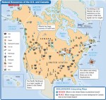
U.S. Possessions
NAVASSA ISLAND Uninhabited island owned by the United States Area: 2 sq. mi. (5.2 sq km) BAKER & HOWLAND ISLANDS Unincorporated territories administered by the U.S. Fish and Wildlife Service as part of the National Wildlife Refuge Official Name: British Indian Ocean Territory Area: 0.5-0.6 sq. mi. (1.40-1.60 sq km), each JARVIS ISLAND Uninhabited territory […]
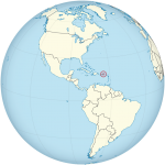
U.S. Virgin Islands
AT A GLANCE Government: Unincorporated; purchased by the United States in 1917 Size: 136 sq. mi. (352 sq km) Population: 102,951 (2016) Electoral votes: 0 U.S. Representatives: 1 (nonvoting) THE PLACE The Virgin Islands are two groups of islands in the Atlantic Ocean, 40 miles (64 km) east of Puerto Rico. They are part of […]
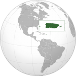
Puerto Rico (USA)
AT A GLANCE Name: Puerto Rico means “rich port” in Spanish. Capital: San Juan Size: 3,515 sq. mi. (9,103 sq km) Population: 3,474,182(2015) Statehood: Unincorporated Electoral votes: 0 U.S. Representatives: 1 (nonvoting) THE PLACE Puerto Rico is an island about 1,000 miles (1,600 km) southeast of Florida, between the United States and South America. Puerto […]
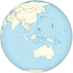
Northern Mariana Islands (USA)
AT A GLANCE Nickname: America's Best Kept Secret Capital: Saipan (38,896) Size: 184 sq. mi. (477 sq km) Population: 53,467 (2016) Statehood: Unincorporated Electoral votes: 0 U.S. Representatives: 1 (nonvoting) THE PLACE The Commonwealth of Northern Mariana Islands is a chain of 16 islands in the Pacific Ocean, south of Japan and east of the […]
Guam (USA)
AT A GLANCE Capital: Hagatna (Agana) Size: 209 sq. mi. (541 sq km) Population: 162,742(2016) Government: Unincorporated territory of United States Electoral votes: 0 U.S. Representatives: 1 (nonvoting) THE PLACE Guam is located in the Pacific Ocean at the southern end of the Mariana Islands. It lies about 1,300 miles (2,100 km) east of the […]
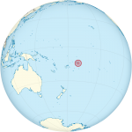
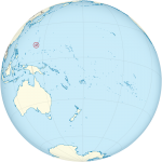
American Samoa (USA)
AT A GLANCE Name: Samoa is a native Polynesian word. Capital: Pago Pago Size: 77 sq. mi. (199 sq km) Population: 54,194 (2016) Statehood: Unincorporated Electoral Votes: 0 U.S. Representatives: 1 (nonvoting) THE PLACE American Samoa is a group of seven islands located about 2,600 miles (4,184 km) southwest of Hawaii. The U.S. federal government […]
District of Columbia
AT A GLANCE Government: The District of Columbia has been the seat of the U.S. government since 1800, and a municipal corporation since February 21, 1871. Area: 68.25 sq. mi. (177 sq km) Population: 672,228 (2015) Electoral votes: 3 U.S. Representatives: 1 (nonvoting) THE PLACE The city of Washington covers the entire District of Columbia, […]
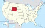
The State of Wyoming
AT A GLANCE Name: Wyoming comes from an Algonquian phrase meaning “large prairie place” or “at the big plain.” Nicknames: Equality State, Cowboy State Capital: Cheyenne Size: 97,818 sq. mi. (253,349 sq km) Population: 586,107 (2015 estimate) Statehood: Wyoming became the 44th state on July 10, 1890. Electoral votes: 3 (2016) U.S. representatives: 1 (until […]
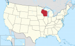
The State of Wisconsin
AT A GLANCE Name: Wisconsin is believed to be taken from one of three possible Indian words—Ouisconsin, Mesconsing, or Wishknosing. The words' meanings are unclear. Nickname: Badger State Capital: Madison Size: 56,145 sq. mi. (145,414 sq km) Population: 5,771,337 (2015 est) Statehood: Wisconsin became the 30th state on May 29, 1848. Electoral votes: 10 (2016) […]
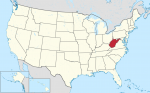
The State of West Virginia
AT A GLANCE Name: West Virginia was once part of Virginia, which was named for England's Queen Elizabeth I. She was known as the Virgin Queen because she never married. Nickname: Mountain State Capital: Charleston Size: 24,231 sq. mi. (62,759 sq km) Population: 1,844,128 (2015 est) Statehood: West Virginia became the 35th state on June […]
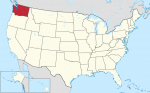
The State of Washington
AT A GLANCE Name: Washington is named after President George Washington Nickname: Evergreen State Capital: Olympia Size: 68,126 sq. mi. (176,446 sq km) Population: 7,170,351 (2015 est) Statehood: Washington became the 42nd state on November 11, 1889. Electoral votes: 11 (2016) U.S. representatives: 9 (until 2016) State tree: western hemlock State flower: western rhododendron State […]
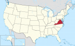
The State of Virginia
AT A GLANCE Name: Virginia was named for Queen Elizabeth I of England, who was known as the Virgin Queen because she never married. Nicknames: Old Dominion, Mother of Presidents Capital: Richmond Size: 40,598 sq. mi. (105,149 sq km) Population: 8,382,993 (2015 est) Statehood: Virginia became the 10th state on June 25, 1788. Electoral votes: […]
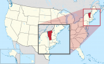
The State of Vermont
AT A GLANCE Name: Vermont is a combination of the French words vert and mont, which mean “green” and “mountain.” Nickname: Green Mountain State Capital: Montpelier Size: 9,615 sq. mi. (24,903 sq km) Population: 626,042 (2015 est) Statehood: Vermont became the 14th state on March 4, 1791. Electoral votes: 3 (2016) U.S. representatives: 1 (until […]
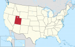
The State of Utah
AT A GLANCE Name: Utah was named for the Ute tribe. Ute means “higher up.” Nickname: Beehive State Capital: Salt Lake City Size: 84,904 sq. mi. (219,902 sq km) Population: 2,995,919 (2015 est) Statehood: Utah became the 45th state on January 4, 1896. Electoral votes: 5 (2016) U.S. representatives: 3 (until 2016) State tree: blue […]
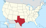
The State of Texas
AT A GLANCE Name: Texas is a Spanish version of a Native American word meaning “friends” or “allies.” Nickname: Lone Star State Capital: Austin Size: 266,874 sq. mi. (691,201 sq km) Population: 27,469,114 (2015 est) Statehood: Texas became the 28th state on December 29, 1845. Electoral votes: 34 (2016) U.S. representatives: 30 (until 2016) State […]
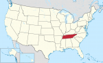
The State of Tennessee
AT A GLANCE Name: The region may have been named after Tanasie, a group of Cherokee villages on the Little Tennessee River. Nickname: Volunteer State Capital: Nashville Size: 42,146 sq. mi. (109,158 sq km) Population: 6,600,299 (2015 est) Statehood: Tennessee became the 16th state on June 1, 1796. Electoral votes: 11 (2016) U.S. representatives: 9 […]
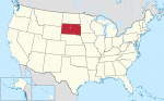
The State of South Dakota
AT A GLANCE Name: Dakota is a Sioux word meaning “friends” or “allies.” Nicknames: Coyote State, Mount Rushmore State Capital: Pierre Size: 77,121 sq. mi. (199744 sq km) Population: 858,469 (2015 est) Statehood: South Dakota became the 40th state on November 2, 1889. Electoral votes: 3 (2016) U.S. representatives: 1 (until 2016) State tree: Black […]
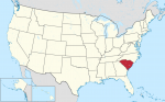
The State of South Carolina
AT A GLANCE Name: South Carolina was named after King Charles I of England. Nickname: Palmetto State Capital: Columbia Size: 31,117 sq. mi. (80,593 sq km) Population: 4,896,146 (2015 est) Statehood: South Carolina became the eighth state on May 23, 1788. Electoral votes: 8 (2016) U.S. representatives: 6 (until 2016) State tree: palmetto State flower: […]
The State of Rhode Island
AT A GLANCE Name: Some historians believe that Rhode Island was named by a Dutch navigator who called it Roode Eylandt (“red island”) because of its red clay. Rhode Island may also have been named for the Greek Isle of Rhodes. Nicknames: Ocean State, Little Rhody Capital: Providence Size: 1,212 sq. mi. (3,142 sq km) […]
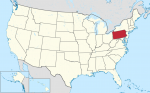
The State of Pennsylvania
AT A GLANCE Name: Pennsylvania was named by King Charles II of England in honor of Admiral Sir William Penn, the father of William Penn, who governed the area. The name means “Penn's woods.” Nickname: Keystone State Capital: Harrisburg Size: 45,310 sq. mi. (117,351 sq km) Population: 12,802,503 (2015 est) Statehood: Pennsylvania became the second […]
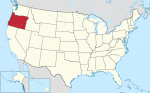
The State of Oregon
AT A GLANCE Name: The exact origin of Oregon's name is unknown, but it may have come from the Native American name for one of the area's rivers—the Ouragon. Nickname: Beaver State Capital: Salem Size: 97,052 sq. mi. (251,365 sq km) Population: 4,028,977 (2015 est.) Statehood: Oregon became the 33rd state on February 14, 1859. […]
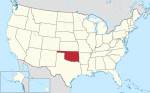
The State of Oklahoma
AT A GLANCE Name: Oklahoma comes from the Choctaw words okla humma, which mean “red people.” Nickname: Sooner State Capital: Oklahoma City Size: 69,903 sq. mi. (181,048 sq km) Population: 3,911,338 (2015 est) Statehood: Oklahoma became the 46th state on November 16, 1907. Electoral votes: 7 (2016) U.S. representatives: 6 (until 2016) State tree: redbud […]
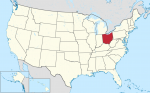
The State of Ohio
AT A GLANCE Name: Ohio is an Iroquois word for “fine or great river.” Nickname: Buckeye State Capital: Columbus Size: 41,330 sq. mi. (107,040 sq km) Population: 11,613,423 (2015 est) Statehood: Ohio became the 17th state on March 1, 1803. Electoral votes: 20 (2016) U.S. representatives: 19 (until 2016) State tree: buckeye State flower: scarlet […]
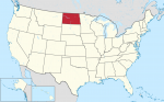
The State of North Dakota
AT A GLANCE Name: Dakota is a Sioux word that means “friends” or “allies.” Nicknames: Sioux State, Flickertail State, Peace Garden State, Rough Rider State Capital: Bismarck Size: 70,704 sq. mi. (13,123 sq km) Population: 756,927 (2015 est) Statehood: North Dakota became the 39th state on November 2, 1889. Electoral votes: 3 (2016) U.S. representatives: […]
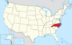
The State of North Carolina
AT A GLANCE Name: North Carolina was named after King Charles I of England. (The Latin word for the name Charles is Carolana.) Nicknames: Tar Heel State, Old North State Capital: Raleigh Size: 52,672 sq. mi. (136,421 sq km) Population: 10,042,802 (2015 est) Statehood: North Carolina became the 12th state on November 21, 1789. Electoral […]
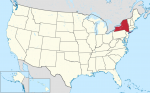
The State of New York
AT A GLANCE Name: New York was named in honor of England's Duke of York. Nickname: Empire State Capital: Albany Size: 49,112 sq. mi. (127,200 sq km) Population: 19,795,791 (2015 est) Statehood: New York became the 11th state on July 26, 1788. Electoral votes: 31 (2016) U.S. representatives: 31 (beginning in 2016) State tree: sugar […]
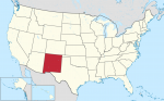
The State of New Mexico
AT A GLANCE Name: New Mexico was named after Mexico by Spanish explorers in the 16th century. Nickname: Land of Enchantment Capital: Santa Fe Size: 121,598 sq. mi. (314,939 sq km) Population: 2,085,109 (2015 est) Statehood: New Mexico became the 47th state on January 6, 1912. Electoral votes: 5 (2016) U.S. representatives: 3 (until 2016) […]
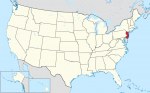
The State of New Jersey
AT A GLANCE Name: New Jersey was named after Jersey, an island in the English Channel. Nickname: Garden State Capital: Trenton Size: 7,790 sq. mi. (20, 175 sq km) Population: 8,958,013 (2015 est) Statehood: New Jersey became the third state on December 18, 1787. Electoral votes: 15 (2016) U.S. representatives: 13 (until 2016) State tree: […]