How Do Sleet and Freezing Rain Form?
RAIN AND SNOW ARE THE MOST COMMON forms of precipitation, but other types of precipitation are also important. The term sleet is used for a mixture of snow and rain or for precipitation as small partially frozen pellets that are too small to be called hail. Freezing rain is precipitation that reaches the ground as raindrops, but that immediately freezes upon contact with cold objects on the surface, such as the ground, roads, plants, and power lines. Can you envision the situations that could cause sleet or freezing rain?
Under What Conditions Do Sleet and Freezing Rain Form?
Sleet and freezing rain are often confused, and they have several similarities. Both result from snow and ice pellets that melt on their way down to the surface as they pass through a layer that is warmer than freezing.
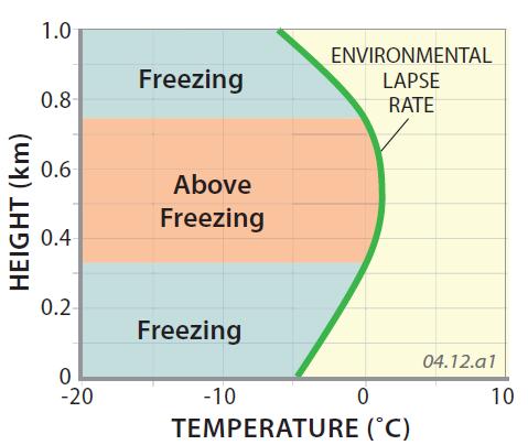
Sleet
This graph shows a hypothetical temperature profile (the green line) that would allow sleet to form. Note that this temperature profile shows a subfreezing layer close to the surface, with temperatures that are colder than those slightly higher in the atmosphere — a temperature inversion. As snow falls, it crosses from freezing conditions through the zone of above-freezing temperatures and then back into freezing ones some distance above the surface. As a result, the snow will at least partially melt on the way down, forming a drop of water that then partially refreezes before it reaches the surface. This creates a tiny pellet that bounces on impact with the surface. This type of precipitation is called sleet.
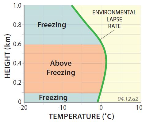
Freezing Rain
This similar graph shows the conditions needed for freezing rain. As for sleet, the temperature profile displays a temperature inversion, but this time with a thinner zone of subfreezing near the surface. As snow falls through these conditions, it will at least partially melt when it encounters the mid-level interval of warmer-than-freezing air. As the drop continues falling, it again encounters freezing temperatures, but not until it is at or right above the surface. As a result, the drop does not have enough time to refreeze, and so hits the surface as rain that sticks to the ground instead of bouncing like sleet. Upon encountering the cold ground and objects on the surface, the drop immediately freezes, forming coatings of ice on the ground and objects.
Where Do Sleet and Freezing Rain Form?
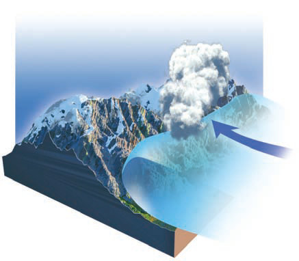
The scenario that provides the best opportunity for the temperature inversion required for the formation of sleet and freezing rain is ahead of the warm front, as shown in the cross section below.
1. A warm front is a mass of relatively warm air that moves across the surface, displacing cold air in its path. In the cross section shown here, the warm air is on the left side (on top) of the frontal boundary and cold air is on the right side of (below) the boundary.
2. The warm air is less dense than the cold air, so it is wedged up and over the colder air mass. If warm air resides above colder air, it creates a temperature inversion. As the warm air is forced to rise, it cools, forming clouds and rain above and along the boundary.
3. Close to the surface position of the front, rain produced along the front only falls through a short vertical interval of cold air. If raindrops pass through this zone without refreezing, they will reach the ground as normal rain. This is the first type of precipitation that announces the arrival of the warm front.
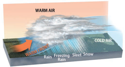
4. Farther back from the surface location of the front, the ground may still be at freezing temperatures. In this case, the rain freezes upon encountering the ground and other cold objects on the surface, producing freezing rain. As the warm front passes over an area hovering near freezing temperatures, therefore, normal rain follows freezing rain.
5. Even farther back from the surface warm front, rain produced aloft must pass through a thicker column of cold air. Thus, raindrops have enough time to freeze on the way down, forming sleet.
6. Snow can be associated with a warm front if the warm air rises so high off the ground that it is below freezing. In this case, the entire profile remains below freezing, allowing snow to form aloft and reach the ground.
What Regions Have a Higher Frequency of Freezing Rain?
1. This map of central North America shows the average annual number of days with freezing rain. Examine this map for regional patterns and try to identify if the place where you live or visit has frequent freezing rain — you probably already know this answer, because freezing rain is not easily forgotten. A map of sleet would show a similar distribution. Since latitude and elevation largely control temperature, they also influence where freezing rain occurs.
2. On this map, freezing rain is frequent in the Midwest, exhibiting a pattern that follows the typical paths of storms as they move eastward across the country. Such storms have a northward (counterclockwise) flow along their eastern, leading edge, bringing relatively warm air from the south that in many cases forms a warm front.
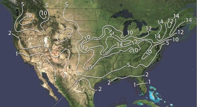
3. Freezing rain is also frequent in the highland areas of the Northeast, including New England and some parts of the Appalachian Mountains. The freezing rain and sleet are the result of the same type of cyclonic storm system as in the Midwest. Sleet and freezing rain are also common in other humid uplands in mid-latitudes around the world, such as the Alps, Japanese highlands, and parts of the Andes of South America.
How Does Terrain Contribute to the Distribution of Sleet and Freezing Rain?
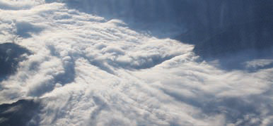
Movement of air against mountains can also cause freezing rain and sleet. When a cold air mass is next to a mountain range, the circulation associated with it will cause air to move upslope as it encounters higher terrain, as shown here. The movement of air can be in response to larger scale clockwise flow (in the Northern Hemisphere) around an anticyclone, or from counterclockwise flow (in the Northern Hemisphere) around a cyclone.
A cold air mass beside the mountain is dense, while the air wedged above it may be warmer, leading to a temperature inversion. While the inversion would also stabilize the local atmosphere above the cold surface air mass, the movement upslope by the circulation around the pressure system may result in forced convection that produces rain at the lowest elevations, freezing rain at higher elevations, sleet farther upslope, and snow at the highest elevations. Mountains that block flow in this way are sometimes referred to as “cold air dams,” as shown in the photograph below. Mountain-caused freezing rain, sleet, and snow are frequent next to the Rocky and Appalachian Mountains in winter.
The Impacts of Freezing Rain
Freezing rain can cause extensive damage and poses severe hazards to animals, plants, and any object on the surface. Freezing rain can coat sidewalks and roadways with a layer of dangerously slippery ice, causing pedestrians to fall and automobiles to skid out of control. Freezing rain resembles rain as it falls, so people may believe that they are only driving in rain when in fact they are driving on an icy road. Even the rain that falls on windshields gives no clue that it will freeze on impact with the surface, because automobile defrosters and friction created by windshield wipers prevent freezing that might alert the driver. The fact that sleet bounces informs motorists to its presence as ice, making it less dangerous.
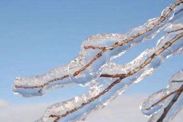
Freezing rain adds considerably to the weight of trees, especially in fall or early winter, when leaves are still attached to tree limbs and branches. This may cause limbs to fall, perhaps onto power lines, which are themselves weighed down considerably by freezing rain. On average, freezing rain causes more deaths and property damage per hour than any other type of storm.