Precipitation
FORMATION OF PRECIPITATION
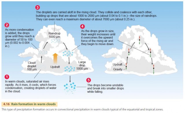
Clouds are the source of precipitation—the process that provides the fresh water essential for most forms of terrestrial life. Precipitation can form in two ways. In warm clouds, fine water droplets condense, collide, and coalesce into larger and larger droplets that can fall as rain. In colder clouds, ice crystals form and grow in a cloud that contains a mixture of both ice crystals and water droplets.
The first process occurs when saturated air rises rapidly and cooling forces additional condensation, as shown in Figure 4.16. For raindrops in a warm cloud, the updraft of rising air first lifts tiny suspended cloud droplets upward. By collisions with other droplets, some grow in volume. These larger droplets collide with other small droplets and continue to grow. Note that a droplet is kept aloft by the force of the updraft on its surface, and as the volume of each droplet increases, so does its weight. Eventually, the downward gravitational force on the drop exceeds the upward force, and the drop begins to fall. Now moving in the opposite direction to the fine cloud droplets, the drop sweeps them up and continues to grow. Collisions with smaller droplets can also split drops, creating more drops that can continue to grow in volume. Eventually, the drop falls out of the cloud, cutting off its source of growth. On its way to the Earth, it may suffer evaporation and decrease in size or even disappear.
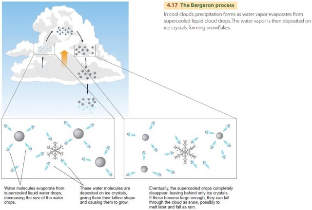
Within cool clouds, snow is formed in a different way, known as the Bergeron process (Figure 4.17). Cool clouds are a mixture of ice crystals and supercooled water droplets. The ice crystals take up water vapor and grow by deposition. At the same time, the supercooled water droplets lose water vapor by evaporation and shrink. In addition, when an ice crystal collides with a droplet of supercooled water, it freezes the droplet. The ice crystals then coalesce to form ice particles, which can become heavy enough to fall from the cloud.
PRECIPITATION PROCESSES
Air that is moving upward is chilled by the adiabatic process, which leads, eventually, to precipitation. However, one key piece of the precipitation puzzle is still missing—what causes air to move upward in the first place? Air can move upward in four ways. In this chapter, we discuss the first two: orographic precipitation and convective precipitation. A third way for air to be forced upward is through the movement of air masses and their interaction with one another. This process occurs as spiral circulations of air, known as cyclones, leading to cyclonic precipitation. The fourth way is by convergence, in which air currents converge together at a location from different directions, forcing air at the surface upward. We will return to these last two types of motion in Chapters 5 and 6.
OROGRAPHIC PRECIPITATION
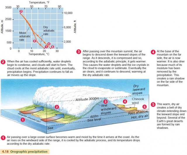
Orographic precipitation occurs when a through-flowing current of moist air is forced to move upward over a mountainous barrier. The term orographic means “related to mountains.” To understand the orographic precipitation process, you can think of what happens to a mass of air moving up and over a mountain range (Figure 4.18). As the moist air is lifted, it is cooled, and condensation and rainfall occur. Passing over the mountain summit, the air descends the leeward slopes of the range, where it is compressed and warmed. Because the air is much warmer and much drier than when it started, little precipitation occurs in these regions, producing a rain shadow on the far side of the mountain.
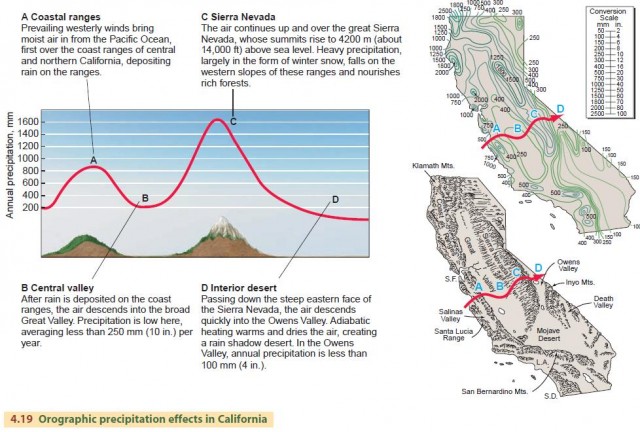
California's rainfall patterns provide an excellent example of orographic precipitation and the rain shadow effect. Figure 4.19 contains maps of California's mean annual precipitation that use lines of equal precipitation called isohyets. These lines clearly show the orographic effect on air moving across the mountains of California into America's great interior desert zone, which extends from eastern California and across Nevada.
CONVECTIVE PRECIPITATION
Air can also be forced upward through convection, leading to convective precipitation. In this process, strong updrafts occur within convection cells—vertical columns of rising air that are often found above warm land surfaces.
Air rises in a convection cell because it is warmer, and therefore less dense, than the surrounding air. The convection process begins when a surface is heated unequally. Think of an agricultural field surrounded by a forest, for example. The field surface is largely made up of bare soil with only a low layer of vegetation, so under steady sunshine the field will be warmer than the adjacent forest. This means that as the day progresses, the air above the field will grow warmer than the air above the forest.
The density of air depends on its temperature—warm air is less dense than cooler air. The hot-air balloon operates on this principle. The balloon is open at the bottom, and in the basket below, a large gas burner forces heated air into the balloon. Because the heated air is less dense than the surrounding air, the balloon rises. The same principle will cause a bubble of air to form over the field, rise, and break free from the surface, as in Figure 4.20.
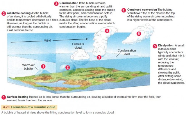
As the bubble of air rises, it is cooled adiabatically, and its temperature will decrease as it rises according to the dry or moist adiabatic lapse rate. The temperature of the surrounding air will normally decrease with altitude as well, but at the environmental lapse rate. For convection to occur, then, the temperature of the air bubble must always be warmer than the temperature of the surrounding atmosphere, even as it rises.
This means that the environmental temperature must decrease more rapidly with altitude than the rising air parcel's temperature.
UNSTABLE AIR
Another way to state this relationship is that the environmental lapse rate must be greater than the dry or moist adiabatic lapse rates. Air with this characteristic is referred to as unstable air. Figure 4.21 shows how to determine whether the atmosphere in a given region is able to support convection and precipitation.
If the environmental lapse rate is greater than the dry adiabatic rate, the air is unstable. If it is less than the moist adiabatic rate, it is stable. Between those two values, the air is conditionally stable.
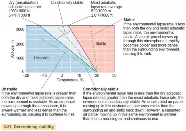
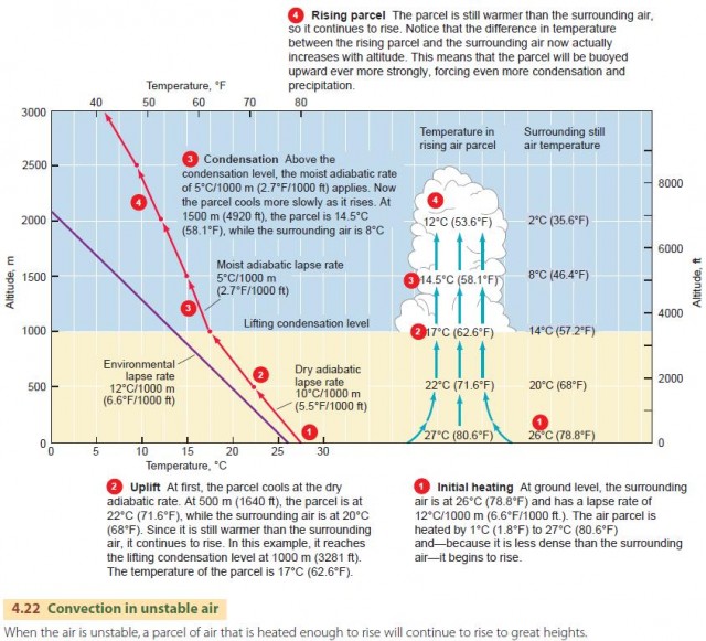
Figure 4.22 is a diagram of convection in unstable air. At first, the air parcel rises at the dry adiabatic rate. Above the lifting condensation level, the parcel cools at the moist adiabatic rate. But because the surrounding air is always cooler than the parcel, it rises high in the atmosphere, forming a tall cumulus cloud. If uplift and condensation persist, it may grow into a rain-producing cumulonimbus cloud.
The key to the convective precipitation process is latent heat release. When water vapor condenses into droplets or ice particles, it releases latent heat to the air parcel. This heat helps keep the parcel warmer than the surrounding air, fueling the convection process and driving the parcel ever higher.
When the parcel reaches a high altitude, most of its water will have condensed. As adiabatic cooling continues, less latent heat will be released, so the uplift weakens. Eventually, uplift stops because the energy source, latent heat, is gone. The cell dies and dissipates into the surrounding air.
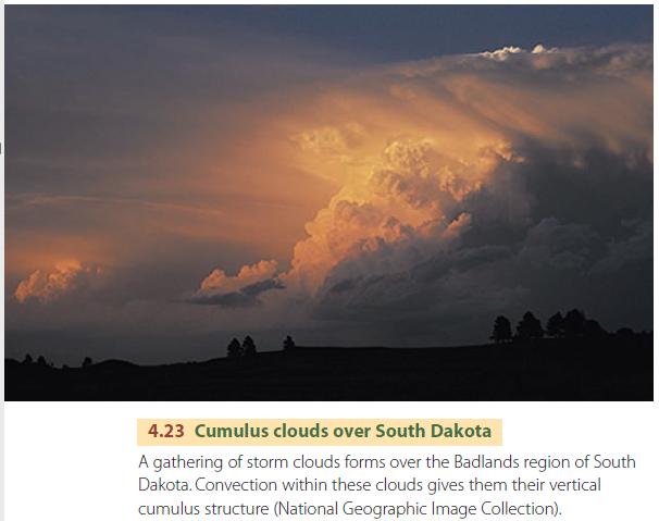
Unstable air masses are often found over the central and southeastern United States in the summer. Summer weather patterns sweep warm, humid air from the Gulf of Mexico over this region, and the intense summer insolation strongly heats the air layer near the ground, producing a steep environmental lapse rate. Thunderstorms are very common in these moist and unstable air masses (Figure 4.23).
Unstable air is also commonly found in the equatorial and tropical zones. Here, convective showers and thundershowers are frequent. At these low latitudes, much of the orographic rainfall is in the form of heavy showers and thundershowers produced by convection. The forced ascent of unstable air up a mountain slope easily produces rapid condensation, which then triggers the convection process.