Becoming
Becoming designates a process based ontology of movement, in which the world is conceived of as a dynamic and open ended set of relational transformations. Becoming is frequently distinguished from and sometimes opposed to being, with the latter suggesting essential and relatively enduring entities (real or ideal) upon which existence, thought, ethics, etc., can be grounded. For philosophies of […]
Beaujeu-Garnier, J.
Jacqueline Beaujeu Garnier (1917–95) was the first woman in France to obtain a Doctorat d'Etat in geography (1947) and the first female geographer to become a university professor (in 1948 at Lille and from 1960 to 1986 in the Sorbonne). She was also incredibly active in numerous academic institutions and editorial bodies in French geography from the 1960s onward. An […]
Barnes, T.
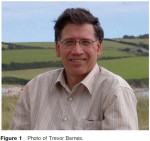
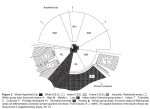
Trevor Barnes (Figure 1) was born in London, England in 1956. Having grown up in Cornwall, he studied economics and geography at University College London between 1975 and 1978. Barnes completed MA and PhD degrees in geography at the University of Minnesota and since 1983 has taught at the University of British Columbia in Vancouver, Canada. He was promoted […]

Modernity and Development
The Legacy of Delayed Development The scale of the differences betweenWest and East in the Ottoman period is widely considered to be the reason for the present lack of development of the peninsula; the front line between two civilizations is seen as having acted as a barrier, retarding the diffusion of the innovations of the modern world initiated by […]
Balkan Civilization – Similarity Is Not Synonymous with Cohesion
The Balkan civilization is difficult to apprehend on account of the negative connotations of the term balkanization. When endeavoring to understand the fragmentation that is the main characteristic, there are two obvious pitfalls: determinism of the natural environment and determinism of history and culture, including repeated violence between groups that are identified sometimes by lifestyle, sometimes by position with respect […]
A Geopolitical Region Where Major Powers Meet: The East, the West, an ‘In-Between’ Europe
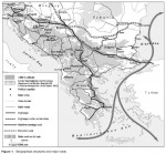
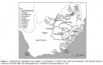
On 1 January 2006, the peninsula comprised eight states: Greece, Albania, Bulgaria, and, resulting from the dismantling of Yugoslavia, Macedonia, Serbia Monte negro, Bosnia Herzegovina, Slovenia, and Croatia. Turkey also has a fragment, and its first city, Istanbul. Romania is also sometimes classified as a Balkan state. The de composition of what was the Yugoslav territory until 1991 is still underway: Bosnia […]
Balkans
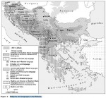
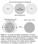
The Meaning of the Word 'Balkan', the Border Issue Defining what the Balkans are is a complex question from the outset, because of the interweaving of fact and representation. Balkan is a Turkish word meaning 'mountain' referring to the Stara Planina, the east–west mountain range that cuts across Bulgaria. The German geographer Zeune used the term Balkan peninsula to identify the […]
Aircraft
The technological advances of aircraft over the past century of manned flight have led to monumental advances in the geographic coverage of air transport. Propeller driven piston engines on the first commercial aircraft limited the range, speed, and number of passengers that the aircraft were able to accommodate. One of the first aircraft to enter commercial service was […]
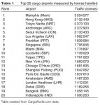
Airports
The geography of airports can be broken into two key areas: the study of airport sites and the study of airport functions. The geography of an airport site looks at the airport at three different scales: international/regional/national scale, local scale, and site specific scale. At the international/regional/national scale the airport's location and function within a larger air transportation network is […]
Airlines
The early international airlines began their services through the mandate of national governments and were used, in the case of some European countries, to serve and reach outlying colonial outposts. It was the location of these outposts and colonial holdings that dictated the early linear networks operated by these international airlines. Early American airlines were used primarily as mail carriers and some […]
Aviation
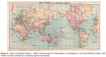
The study of air transport geography can be divided into three sections of inquiry: airlines/industry, airports, and aircraft. Air transport geographers are generally concerned with examining the role these different components have, either separately or in combination, in the geographic distribution of human activities across space. The majority of air passenger and cargo traffic is concentrated in and between three regions: North America, […]
Avant-Garde: Translating the Esthetic into Politics
Addressing the conceptual purchase of the avant-garde, one can combine the relationship of the esthetic to the political by unpacking the arts into three key categories – that of experience, performance, and expression – while distilling and summarizing their respective influence as manifested through, and housed within, the spatialities of particular institutions and communities. Within this telling of the avant-garde, it is […]
Avant-Garde/Avant-Garde Geographies
The avant-garde is predominantly a modernist term for a movement in art, culture, and politics that cuts at the vanguard of ideas both in terms of their mode of expression and the social impact that they have for everyday living. As a term, it does however have roots in the Renaissance for signaling an advanced position in the arts, and further […]
Auto-Photography. Challenges
There are several practical challenges for using auto-photography in human geographic research. These include the cost of cameras and film development, the likelihood that photo quality will be poor and inconsistent, and the possibility that participants will drop out of the research project over time. Conceptual challenges also exist. In human geography there is very little theoretical or conceptual work […]
Purposes of Auto-Photography
Photographs derived from the auto-photographic field method contribute to ethnographic research in numerous ways. First, because photos are seen, they are considered visual data. In geography the visual has always been an important dimension of scholarship and the production of knowledge, for example, through cartography and landscape analysis. Photographs taken by research subjects consist of a radically different genre of visual […]
Genealogy of Auto-Photography
Auto-photography is an ethnographic research method that has its historical roots in nineteenth-century anthropology. In many ways, ethnography and photographic methodologies were born together. Photos were often taken in the field and then presented to academic and popular audiences to show the 'savage' culture faraway in lands (or the 'natives' on colonized lands like in North America and Australia) and […]
Auto-Photography
Auto-photography usually entails the following steps: first, a researcher gives cameras to research subjects and asks them to photograph particular places and people that are relevant to the topic of the research project. (In some cases, cameras may be distributed with no prior information about the research given, however.) These instructions may be prefaced by an initial interview or other participatory research […]
Autoethnographies
A strategy of combining autoethnography that is committed to self reflexivity with an autoethnographic sensibility allows for more complex representation and analysis of the research setting. Representing the research setting as one in which knowledge is co produced, in which researchers use autoethnography of the first type along with recognizing the many moments in which ethnographic subjects disclose knowledge, […]
An Autoethnographic Sensibility
One response to these criticisms may come from employing an autoethnographic sensibility, the second way human geographers might approach autoethnography. Geographers David Butz and Kathryn Besio outline what they call an autoethnographic sensibility, drawing from the work of literary critic Mary Louise Pratt. Pratt conceptualizes autoethnographic texts as those produced by indigenous others in order to represent themselves to their others […]
Autobiography and Ethnography
In the first and perhaps most intuitively accessible understanding to researchers, autoethnography refers to a type of ethnographic writing that seeks to combine elements of 'autobiography' with 'ethnography'. The 'auto' in autoethnography, the 'self ', is the researcher, most often a Western trained researcher, who draws upon their own biographies to foreground social relations. However, there are also 'native' ethnographers who work from […]
Autoethnography
Autoethnography, like ethnography, is both method and text. That is, it is a textual record of people and places, and way of doing qualitative research that relies on participant observation or using the ethnographic method of embedding the researcher in settings in order to write about social groups unlike those of the re searcher. In contrast to ethnography, autoethnography is distinguishable by […]
Autobiography in Geography
The place of autobiography in geography is currently in flux. On the one hand, it is fair to say that ''autobiographical approaches are not widely accepted as a standard method for geographic research'' (Moss, 2001a: 190). In part, that lack of acceptance can be attributed to a lingering positivism that devalues autobiography because it does not produce 'objective' […]
Four Forms
In trying to pinpoint exactly what is an autobiography, it is worth trying to understand its relationship to similar forms of inquiry. Biography, ethnography, and auto ethnography are perhaps the closest cognates. On the surface, there are differences clear enough one might even be tempted to put them in a matrix (see Table 1). It appears that autobiography is what a […]
Autobiography
As I understand it, the idea of an article like this is for the editors to choose an expert on a topic, and ask that expert to call upon his or her vast existing knowledge to communicate what we currently know about the topic. I am not an expert on the use of autobiography in geography, or I do […]
A Contemporary Australasia?
If the link between colonial imaginations of Australasia as a distinct world region can be seen to neatly translate onto contemporary scientific classification and nomenclature, the story is not nearly so simple in the spheres of politics and society. Most simply, there is no clear wisdom on what countries are contained in the geopolitical entity known as Australasia, and whether […]
Australasia as Ecoregion
The apex of the use of Australasia as a place name stemmed from its acceptance as a scientific term to describe a unique ecoregion. This emphasis on ecological uniqueness was, along with theories about racial difference, a central concern of Europeans in their attempts to distinguish and classify world regions. Early evidence of a distinction between Asia and lands […]
Colonial Origins and Imaginations
Australasia is an invented name, the product of European desires to scientifically describe and classify the world's geography. The name Australasia is the English translation of Australasie, first coined by Charles de Brosses, an aristocratic French magistrate and politician (he became president of the Burgundy parliament), who collected, synthesized, and translated, into French, accounts of all the voyages made to the […]
Australasia
Australasia is a geographic place name for a large region of the southern part of the world. As to which countries are considered a part of Australasia has not been universally defined. Different countries are included depending on the use of the term, and throughout its history, Australasia has often been used interchangeably (and usually no more accurately) with […]
Atlas Information Systems
As stated before, atlases can be considered comprehensive spatial information systems of a particular region irrespective of their production and presentation media. They represent the complex human and physical environment in a narrative based collection of applicationspecific, synoptic, and significant map and other graphics. This may include static data presentations like static maps, tables, text, and images, as well […]
Dissemination Medium
Paper Atlases Traditionally, atlases have been and are still published in book form or as single map sheets assembled in a map case. Such conventional atlases offer the user a clear structure. Although paper atlases allow for browsing through the different chapters, they also guide the user by their sequential setup. Atlas chapters and themes are arranged to facilitate the best […]
Types of Atlases
Atlases, whether in conventional or electronic form, portray (1) a clearly defined region geographically or (2) a specific topic or theme. General-Reference Atlases Atlases can depict a specific area or cover the entire Earth. The latter are often referred to as general refer ence atlases and contain mainly small scale physical maps to emphasize locations of places and their spatial relationships. […]
Historical Background
The development of atlases can be divided into different stages. The first stage of atlas development is defined by Ptolemy's Guide to Geography (Geographike hyphegesis), which dates back to the second century AD. In volume 8 of the guide Ptolemy included instructions on how to show the Earth in maps and also included 26 maps. The guide was unknown until […]
Atlases
Every systematic application specific collection of maps with uniform formal structure and design is termed an atlas after a book collection of world maps by the German Dutch cartographer Gerardus Mercator more than four centuries ago. Since Mercator's time the term atlas implies not only a specific map content, a system of map models based on a common narrative, but […]
Asia as Political Ideology and Populist Movement
''My Asiatic blood has always called to other Asiatics. In my dreams, both sleeping and waking, I have heard the voice of Asia calling to her childreny. TodayyI seem to hearythe same voice of Asia gathering her children together. It is the call of our Asiatic blood. This is not the time to think with our minds; this is the […]
Asia as an Asian Intellectual Project
Does Asia Exist? In 1963, provoked by the appearance of yet another Western book questioning the validity of Asia as a meaningful label for such a vast and diverse space, Indian journalist Romesh Thapar regarded the question of Asia's existence with understandable indignation. But Thapar did concede that the ''image'' of Asia is ''blurred.'' ''Yet if we act with good sense,'' […]
Asia as Other
What is Asia? As Edward Said observed in Orientalism (1978), Asia has played a crucial role in the stories Europe has told about itself. It has done so by always occupying the other side of Europe in a set of binary couplets: rational–emotional, reason–faith, analytical–aesthetic, and so on. Perhaps the two pairings among these which have had the most purchase have […]
Asia
As the largest of the world's continents, comprising a third of the earth's land area and some two thirds of the earth's population, Asia's size and diversity have always represented a challenge to the categories and conventions of regional geography. Overcoming this challenge has preoccupied a great deal of work within and beyond the discipline. It has become standard practice, for […]
Intelligent Decision Support System – An Integration
In geographical analysis, the demand on domain specific knowledge, technical know hows, and accessibility to data is tremendous. It is difficult to make good decisions without powerful systems to provide, in an integrative way, supports in various phases of the decision making process. Taking the three phase process as an example, the system needs to support, for instance, problem diagnosis, access and […]
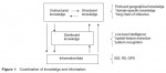
Acquisition of Spatial Knowledge
Symbolic approaches to spatial knowledge representationand inference are discussed and applied to construct expert systems in the previous section. Logic (fuzzy and nonfuzzy), production systems, semantic networks, frames, object oriented programming, and their hybrids all belong to symbolic systems in which knowledge is modeled by symbols. Intelligence is realized by a symbolic structure in which symbols can be manipulated and reasoning […]
Expert Systems for Domain-Specific Problems
The major challenge in the design of intelligent spatial reasoning systems lies on our ability to build into a system mechanisms to memorize and use knowledge extracted from domain specific experts, and to automatically acquire knowledge from voluminous but incomplete information through learning by examples. Such system can facilitate machine reasoning in a commonly encountered environment where knowledge (in terms […]
Spatial Knowledge Representation and Inference
Geographical knowledge may be structured or unstructured. We may organize our knowledge in a highly structured form so that problems can be solved by sys tematic and rigid procedures. Mathematical models, statistical methods, and heuristic procedures are knowledge in procedural form. They follow a rigid framework for the representation and analysis of structures and processes in space and time. Procedural […]
Artificial Intelligence and Expert Systems
With our ability to amass information from various sources, geographers are encountering information explosion in their analyses. Facing an almost unabated growth of information, it is absolutely necessary to apply geographical knowledge and expertise to streamline, analyze, manage, digest, visualize, and integrate information in an efficient and effective manner. Without knowledge, information becomes static and perhaps useless in our analysis of […]
Invisible Data Mappers: Artists Who Use Cartographic Metaphors to Visualize Informational Territories Such as the Stock Market, the Internet, or the Human Genome
The twentieth century witnessed many technological and social changes as people developed new ways of sensing the world, communicating with each other, killing each other, and moving through space. These changes helped spawn what might be called 'informational territories' – virtual, invisible, infinitely small or large, multidimen sional, time based, and even cultural and political 'spaces'. The Internet, the stock market, the […]
Agents and Actors: Artists Who Make Maps or Engage in Situated, Locational Activities in Order to Challenge the Status Quo or Change the World
In the twentieth century, particularly during the destruction, chaos, and geo scrambling of World War I, avant-garde artists began not only to take on the iconography of the map but also to envision themselves in the roles of mapmakers, which is to say, capable of leveraging the authority of the map to change the shape of the world. The […]
Symbol Saboteurs: Artists Who Use the Visual Iconography of the Map to Reference Personal, Fictional, Utopian, or Metaphorical Places
As a result of advances in printing and image reproduction technologies, by the late nineteenth-century, maps and globes had become affairs of everyday life in Western nation states. Atlases, such as Blackie's Imperial Atlas of Modern Geography (1860), were standard fare in children's education in the late nineteenth-century. The classroom globe served to instruct pupils as to the shape of their […]

Art and Cartography
In the last century, and especially in the last 30 years, artists have made maps, subverted maps, performed itineraries, imagined territories, contested borders, charted the invisible, and hacked physical, virtual, and hybrid spaces in the name of cartography. Numerous names have been suggested for various strains of this intersection: 'psychogeography', 'locative media', 'experimental geography', 'site specific art', 'new genre […]
‘Nature’, the Economy, and Changing Research Initiatives
Post war governments utilized the Arctic as nuclear laboratory, but a contrary ecological consciousness emerged amidst efforts of 'big science' to control nature. While the Soviets relocated Nenets to conduct tests on Novaya Zemlya, the US Atomic Energy Commission (AEC) tested bombs on Amchitka Island, Alaska. This then inspired the organization of Greenpeace. The AEC's peacetime efforts had included plans […]
Science and State Colonialisms
In the early twentieth century, arctic science continued its service to governments and nations. Little was left of the terra incognita that Wright studied 40 years later. Rather than being unknown, many narratives of arctic lands had accrued in imperial archives. Most shorelines had been mapped and aerial surveys would soon be introduced. Sublime landscapes that had once leant currency to grand […]
Migration, Expedition, and Inscription
In his address to the Association of American Geographers in January 1937, W.H. Hobbs began a familiar historiography of 'Exploration within the Arctic Region' around the year 330 BC, when a Greek geographer named Pytheas began a 6 year voyage to the north coast of Britain. There, Pytheas heard about a land called Thule, which he then claimed to reach […]
Arctic
With regularity, studies of the Arctic begin with comments about the difficulties of defining the region. Its name is derived from the Greek word, Arktos (meaning bear), for the constellation around the Pole Star. In its earlier meaning, the Arctic Circle defined that part of the sky, but it now refers to a line of latitude (currently 661330 N) north […]
Archive Fever?
Compared to studies of documentation and the material of documents in geography, the disciplinary effort that has been put into reconceptualizing the archives – the locations where such documents are preserved – is far more explicit and fecund, making a notable change. Up to the 1980s, any mention of archives was usually confined to footnotes. When they were discussed, this would […]
Documents of a Material Culture
The fascination with archives and documents as cultural artifacts has arisen in geography for a number of reasons. First, digital publication software and the globalized workforce that assembles cameras, scanners, and other inexpensive mechanical reproduction technologies have enabled scholars to produce facsimiles of particular documents, such that they can then pay close attention to the form and quality of a document through […]
Archives
Document based and archival research has been quietly undergoing a wholly remarkable change over the last decade. Once largely set aside in human geography as a means to an end, documents and archives are no longer seen simply as a goldmine for the extraction of select elements and valuable information, or as the source of data about some other interesting phenomenon […]
Applied Geography and Public Policy
The practical value of the applied geographical approach has been demonstrated in the foregoing discussion. Applied geographers are actively engaged in investigating the causes and ameliorating the effects of 'natural' phenomena including acid precipitation, landslides, and flooding. Key issues of environmental change and management also represent a focus for applied geographical research with significant contributions being made in relation to […]
Values in Applied Geography
At each stage of the research process the applied geographer is faced with a number of methodological and ethical questions. Decisions are required on defining the nature of the problem, its magnitude, who is affected and in what ways, as well as on the best means of addressing the problem. All of these require value judgments on, for example, the […]
The Value of Applied Geography
A fundamental question for those working within the framework of applied geography concerns the value of a problem oriented approach. We have examined this issue already in our discussions of useful knowledge and the relationship between pure and applied research but we return to it here to address the specific critique of applied geography that has emanated from Marxist theorists. While the […]
The Relationship between Pure and Applied Research
Applied research in any discipline is best understood in contrast with basic, or pure, research. For some commentators basic research in geography aims to develop new theory and methods that help explain the processes through which the spatial organization of physical or human environments evolves. In contrast, applied research uses existing geographic theory or techniques to understand and solve specific […]
The Concept of Useful Knowledge
The concept of useful knowledge is of central importance for applied geography but is problematic for some practicing geographers. Those who do not see themselves as applied geographers may interpret the concept as indicating a corollary in the shape of geographical research that is less useful or even useless. This would be a misinterpretation. The concept of useful […]
Applied Geography
The rationale underlying applied geography is based on the particular philosophy of relevance or social usefulness that focuses on the application of geographical knowledge and skills to advance the resolution of realworld social, economic, and environmental problems. Rather than being considered as a 'subarea' of geography, (akin to economic, social, or historical geography), applied geography refers to an 'approach' […]
Other Apartheids
There have been numerous claims of other apartheids around the world, in countries as diverse as Northern Ireland, the USA, Israel/Palestine, and Brazil. If we accept the United Nations definition of apartheid used at the start of this article, it is debatable whether these can be considered apartheid equivalents. What constitutes institutionalized racial segregation and discrimination? There is indeed segregation within […]
Post-Apartheid
The end of apartheid as a political force heralded the start of the post apartheid era. However, post apartheid South Africa is in many ways still attempting to liberate itself from the legacy of apartheid and precursors. The multiscalar spatial reach of apartheid impacted upon every area of life for individuals and communities in a complex, interlinked manner. Therefore, the success […]
Towards Ending Apartheid
Although apartheid officially ended in 1994, when South Africa held its first democratic election, it had been in a period of transition for a number of years, possibly as far back as the early 1970s. Reasons for the decline of apartheid can be broadly divided into agency based and structure based arguments. Agency based arguments reflect the popular narratives of […]
The Nature of Apartheid
The degree of segregation in existence before 1948 has led some to argue that apartheid was simply a continuation of what was already in process. However, the election of the National Party brought a far more comprehensive kind of segregation to what had gone before. Between 1948 and 1951 a series of acts were passed to lay the foundation […]
From Segregation to Apartheid
Many of the building blocks of apartheid were in existence by the time the National Party was elected to power in 1948, leading some commentators to stress the continuity from pre apartheid to apartheid, from de facto to de jure segregation. The Union of South Africa was formed in 1910 from the British Colonies of Natal and the […]
Apartheid/Post-Apartheid
The apartheid era in South Africa existed for 46 years, between 1948 and 1994. However, its historical reach can be traced considerably further back into the country's history and forward into present lived experiences. Apartheid (literally: 'state of being apart' in Afrikaans) was perhaps most clearly defined in the 1985 United Nations International Convention Against Apartheid in Sport as, ''a system of […]
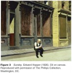
Case Study: Edward Hopper’s New York
Great art is the outward expression of an inner life in the artist, and this inner life will result in his [sic] personal vision of the world. Edward Hopper, 1953 (quoted in Hobbs, 1987: 64) Edward Hopper (1882–1967), an artist with a huge posthumous following (a traveling retrospective of his work in the summer of 2004 drew massive crowds to galleries […]
Dislodging the Good Life, Disrupting the Rural
Industrialization proved to be the force that dislodged widespread pro urbanism. The good city for the good life morphed into Frederick Engels' Manchester, Henry Mayhew's London, and Upton Sinclair's Chicago, to name but a few representations of the industrial city as dirty, dark, crowded, anonymous, threatening to the weak, a jungle of brick, stone, and smoke. These representations were powerful in […]
Origins: The Good Life
In order to understand where anti-urban sentiment came from, we must appropriately invert one of the key principles of the natural sciences (especially geology), uniformitarianism, often summed with the statement: 'the present is the key to the past'. For our purposes, the past is the key to the present, and therefore we must acknowledge the widespread and deeply entrenched […]

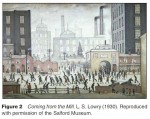
Introduction: 100% Urban Proof
In early 2007 Nissan launched a new model of sport utility vehicle (SUV), the Qashqai. The massive in your face marketing campaign described the Qashqai as ''100% Urban Proof '' – posters were designed showing a triumphant tank like vehicle protected from gritty looking streets, with the backdrop of walls plastered in menacing graffiti (Figure 1). The website takes the […]
Anti-Urbanism
Introduction: 100% Urban Proof Origins: The Good Life Dislodging the Good Life, Disrupting the Rural Case Study: Edward Hopper's New York
Critique of Anti-Geopolitics
The notion of anti-geopolitics is a very recent one, barely 10 years old. Some of its associated ideas have attracted analytical attention, such as the anti-geopolitical eye in feminist geopolitics. The term anti-geopolitics in itself, however, has not found widespread application to date. Its use has mainly been restricted to a handful of writers from the Anglo-American critical geopolitics perspective. It has […]
Anti-Geopolitics as Perspective
Geopolitics has always been a contentious form of knowledge and practice, and there have been many critiques to dominant geopolitical reasoning. These range from the orthodox Marxism of the German communist Karl Wittfogel in the 1920s to the poststructuralist interventions of the critical geopolitics school of the 1980s. More recently, feminist geographers have called for a feminist geopolitics. They expose the […]
Anti-Geopolitics as (Radical) Politics
The policies and strategies of empires, colonial powers, dictatorships, and states have rarely gone unchallenged by those who have been subjects to various degrees of domination and exploitation. Quite on the contrary, dominating power has almost always faced resistance from various forms of counter hegemonic struggles. Proponents of anti-geopolitics focus on the latter as enacting a geopolitics from below that emanates from subaltern […]
Origin and Context of the Term Anti-Geopolitics
The term anti-geopolitics emerged in the English speaking literature in the mid 1990s. Although the term is briefly mentioned by O Tuathail in 1996 (then spelt without hyphen as antigeopolitics), it was only in 1998 that it was conceptually developed in the first edition of the Geopolitics Reader, edited by O Tuathail, Dalby and Routledge. Subsequently, Routledge has published slightly edited versions […]
Anti-Geopolitics
Origin and Context of the Term Anti-Geopolitics Anti-Geopolitics as (Radical) Politics Anti-Geopolitics as Perspective Critique of Anti-Geopolitics
Geoarchaeology, Environmental History, and Causality
A very different intersection between anthropology and geography came about in the form of geoarchaeology, another integrative approach. Although geoscience applications to problems of dating, environmental reconstruction, and spatial organization in archaeology are common (mainly as 'archaeological geology'), and rapidly gaining in popularity, direct attention to the nature of the archaeological record is not. That record is a proxy for human […]
Cultural Ecology as a Reunion
In the wake of New Guinea, anthropologists and geographers began to rediscover common ground in what was then called cultural ecology. This approach concentrated on processes rather than material culture – subsistence, work, reproduction, and resource use – and their interrelations – as embedded in the rules and values of a particular society. The configurations could be functional, behavioral, […]
Anthropology and the Berkeley Tradition
Kroeber, who became professor of anthropology at Berkeley in 1919, was instrumental in bringing Carl Sauer (1889–1975) to the University of California, to found its department of geography in 1923. Yet Sauer's early signature publication, The Morphology of Landscape (1925), focused on an ongoing discourse in German geography and does not yet reveal the close connection that had developed between Sauer […]
The Bridge between Human Geography and Anthropology
A major figure in this transition was Friedrich Ratzel (1844–1904), trained as a zoologist and an admirer of Darwin. He was appointed to the chair of geography at Leipzig (1886) but carried out his most influential work in what today is anthropology. Traveling widely, he worked as an itinerant reporter in the USA (1872–75), publishing Urban and Cultural Images of North […]
An Attenuated Separation
Interdisciplinary relationships are a reminder that traditional university disciplines are historical constructs that do not necessarily promote innovative teaching and research. Some disciplines have long shared a measure of organic integrity, but the 'newer' social sciences did not. Geography, together with anthropology, sociology, and political science, occupied a poorly articulated middle ground between the natural sciences, history or philosophy, and language […]
Anthropology and Human Geography
An Attenuated Separation The Bridge between Human Geography and Anthropology Anthropology and the Berkeley Tradition Cultural Ecology as a Reunion Geoarchaeology, Environmental History, and Causality
Political Impact and Deterministic Content of Ratzel’s Geography
Against the background of such statements most commentators, after the end of World War II and up until today, have come to think of Ratzel's geography in rather ambivalent terms. While the central role Ratzel played for the development of the discipline is mostly recognized, his anthropogeography has been criticized for being deeply environmental deterministic. Ratzel, so the general opinion, […]
Anthropogeography as Imperialist Transformation of the Classical Paradigm of Geography
It is against the background of the competing geographical imaginations that Hans Dietrich Schultz sees a ''cycle of growth and defeat, of progress and collapse'' at work in Ratzel's writings (Schultz, 1998: p. 140). Since the surface of the Earth is limited, the natural impulse of growth necessarily leads to a form of spatial implosion which, in turn, represents the […]
Competing Geographical Imaginations
Ratzel argued that the state as spatial organism 'naturally' seeks to grow beyond a given area. Due to an increase in population which he regards as being ultimately dictated by the laws of nature, the space need of a state organism would grow. The resulting tendency of the state to require – and acquire – new territory is a […]
Darwinian Concepts
All of this is not to say, however, that Ratzel's perspective turned geography, in any way, into a social science. Although anthropogeography (re)introduced human aspects into a predominantly physical geography, it firmly rested on a framework of causal explanations, cause–effect relationships, and natural laws characteristic for the sciences of his era. As a consequence, Ratzel was criticized by his […]
Is Geography an Independent Discipline?
Why is Ratzel's geography regarded so central for the development of the discipline? In order to answer this question, an investigation into the broader academic context in which anthropogeography evolved is insightful. During the last third of the nineteenth-century, that is, by the time Ratzel was appointed as an academic geographer in Germany, geography underwent its insti tutionalization as an academic […]
Tracing Anthropogeography in Ratzel’s Work and Life
The first of these publications was a two volume regional geography of the United States, consisting of Physikalische Geographie und Naturcharakter der Vereinigten Staaten von Amerika and Culturgeographie der Vereinigten Staaten von Amerika. While the latter, according to Wolfgang Natter, contained a somewhat 'totalitarian' approach considering ''every side of cultural life in North America'' (Natter, 2004: p. 175), it was not before […]
Friedrich Ratzel
Having published more than 1200 papers and books, not including book reviews, Ratzel represents an exceptional academic and a rather abundant writer. A big part of his oeuvre dates back to his earlier years when he worked as a journalist for the Ko?lnische Zeitung. In order to help finance his academic education, he had begun to write popular natural scientific reports […]
Anthropogeography (After Ratzel)
Anthropogeography, or the geography of Friedrich Ratzel, is widely acknowledged as the groundwork of human geography. Ratzel (1844–1904), who had studied, among other subjects, zoology in Heidelberg and Jena, was a German pharmacist, zoologist, and journalist. After having traveled over much of Europe as well as of North and Central America, he became established as an academic geographer first in Munich and […]
Antarctica: Conclusion
Today, the prime purpose of the ATS is no longer the containment of the East–West confrontation of the Cold War. Technological developments and steadily expanding economic/commercial interests imply that certain actors are looking to realize economic benefits from the region. So long as human activity in the Antarctic was of a limited scale, science oriented, and perhaps largely under the direct control […]
Growing Focus on Biological Prospecting
Biological prospecting is taking place in the Antarctic, and some Antarctic life forms have already been 'protected' with patents. The US Patent Office database contains more than 300 references to Antarctica and 92 applications for patents that refer to Antarctica, while a similar survey of European Patent Office records contains at least 62 patents that rely on Antarctic biodiversity. The question […]
Imagining Antarctica as a World Park: Regulating Tourism
Managing tourism in extremely scenic but ecologically sensitive Antarctic, whose chief export remains scientific data, has emerged in recent years as one of the key questions facing the ATS, characterized by steep annual increases, diversification, and geographical expansion. The increasing number of tourists visiting specific or select, more accessible, and logistically considered as safe areas on the continent or its surrounding islands […]
Antarctica as a ‘Natural Reserve’ Devoted to Peace and Science: Since the 1990s
Since the 1990s, the Antarctic has increasingly been represented in global ecological terms. The growing body of evidence purporting to link the polar continent to possible global climatic change has been used by scientists and scientific organizations to explain and legitimize their endeavors. Antarctic is being increasingly seen not only as a barometer of global environmental and resource debates but […]
‘Question of Antarctica’ in the United Nations: The Rise and Decline of Alternative Visualization of the Antarctic
The interest of the 'outsiders' in the icy continent arose as early as early 1980s and somewhat in direct proportion to the origins and evolution of minerals issue within the ATS. Malaysia was to emerge as the most vociferous and dissatisfied among the critics of the ATS. The Malaysian position reflected, in part or whole, that of the most of […]
Growing Focus on the Resource Geopolitics: Southern Polar Region during 1970s and 1980s
The 1970s were a landmark in the discursive transformation of the Antarctic. By this time a rather impressive outline of Antarctic resources had emerged as a result of extensive geological and biological research of the region. This was soon filled in by perceptions of the burgeoning population in terms of consumption and depletion of resources in the wake of the […]
Antarctica as a Continent of Science and Peace: 1950s and 1960s
The Antarctic Treaty (cited hereafter as the Treaty), with a preamble and 14 articles, was signed on 1 December 1959 by the representatives of the 12 IGY participating countries – Argentina, Australia, Belgium, Chile, France, Japan, New Zealand, Norway, South Africa, United Kingdom, United States of America, and USSR. It took effect on 23 June 1961. The preamble to the Treaty underlines […]
IGY (1957–58) and the Discursive Transformation of the Antarctic
It was science, especially the IGY held during 1957–58, which transformed Antarctic politics and laid down the groundwork for the Antarctic Treaty of 1959. More than 40 research stations and observatories were established during this period, and thousands of scientists were located on the continent. There was more or less a tacit agreement among the participating countries that political problems regarding the […]
Antarctica in the Cold War Ideological Geopolitics (1950s and 1960s)
The dominant spatial representations of the Antarctic during the 1950s were affected by the Cold War discourses. Earlier on, there were clashes between Britain and Argentina over the issue of territorial ownership. By late 1947, Antarctic affairs assumed immense significance in foreign policy considerations of the US, and the impetus for this shift in focus had more to do […]
Antarctica
With a total area of about 5.5 million square miles (or some 14 million km2) constituting one tenth of the world's land surface, Antarctica is far larger than India and China put together. Right through the nineteenth century and up to World War II, human presence and activity in the Antarctic was rather patchy, both spatially and temporally. Thereafter, and particularly […]
A Shift of Responsibility
Agricultural modernization arguably took the issue of animal welfare out of the traditional moral realm of stewardship and into the domain of science. Empiricism and the scientific method, under the paradigm of agricultural progress, furnished animal science with a refuge from overt and explicit ethical engagement. Although the contested anthropocentrism of Enlightenment thinking contested the moral acceptability of the cruel treatment of […]