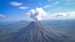
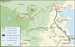
Kamchatka Peninsula
RUSSIA'S FAR EAST IS MARKED by the large mountainous peninsula known as Kamchatka. Kamchatka peaks form one of the most volcanically active regions on earth, counting over thirty active cones, and at least a hundred more that are now inactive. Few people live in this remote corner of Asiatic Russia, where ties to central government, […]
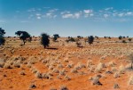
Kalahari Desert
THE NAME KALAHARI is derived from the Tswana word Kgalagadi, meaning “the great thirst.” The Kalahari Desert, an arid region on the interior plateau of southern Africa, covers area in central and southwestern BOTSWANA, parts of west-central SOUTH AFRICA and eastern NAMIBIA, encompassing an area of about 100,000 square mi (260,000 square km). The Kalahari […]
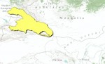
Junngar Basin
THE JUNNGAR BASIN (also Dzungar) is one of the two major basins that make up much of northwestern CHINA's XINJIANG province (Xinjiang Uygur Autonomous Region). The basin, covering some 69,500 square mi (180,000 square km), is located to the north of the TIAN SHAN MOUNTAINS and has a mixed landscape that includes mountains, deserts, steppes, […]
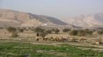
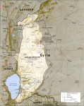
Jordan Valley
THE JORDAN VALLEY is part of the Great Rift Valley stretching from East Africa to northern SYRIA. Massive cracking of the Earth's crust caused by tectonic plate movements under the continents of Africa and Asia formed a trench over 4,000 mi (6,438 km) long. The northern section created by this faulting activity is the Jordan […]
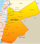
Jordan
Area 35,536 square mi (92,300 square km) Population 6.607 million 2014 Capital Amman Highest Point 5,689 ft (1,734 m) Lowest Point -1,340 ft (-408 m) GDP $35.83 billion 2014 Primary Natural Resources phosphates, potash, shale. JORDAN IS A MIDDLE Eastern country located in southwest Asia. Its official name is the Hashemite Kingdom of Jordan and […]
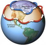
jet stream
A JET STREAM IS A relatively narrow band of strong horizontal winds in the atmosphere. This band is 100 to 200 mi (250 to 500 km) wide and 1 to 2 mi (several km) deep. The winds in this band are stronger than those in horizontal or vertical regions adjacent to this band. The boundaries […]
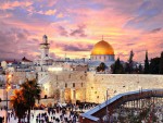
Jerusalem
THE CAPITAL CITY of the state of ISRAEL, Jerusalem is located in the center of the country. Jerusalem is Israel's largest city, with an area of 48 square mi (126 square km) and a population of 657,500 (2000), of which 68 percent are Jewish and 32 percent mostly Arab. The city is divided into two […]
Java
WITH A population exceeding 120 million, crowded into a space about the size of NEW YORK state (but with nearly six times the population), the island of Java is one of the most densely populated places on Earth (2,070 inhabitants per square mi or 864 per square km). Java is not the largest of the […]
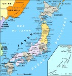
Japan
Area 145,843 square mi (377,835 square km) Population 127.1 million 2014 Capital Tokyo Highest Point 12,389 ft (3,776 m) Lowest Point -13 ft (-4 m) GDP $4.601 trillion 2014 Primary Natural Resources coal, copper, rice, sugar beets. JAPAN IS AN ISLAND nation occupying a long, relatively narrow mountainous archipelago of four large and about 3,000 […]
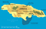
Jamaica
Area 6,829 square mi (10,991 square km) Population 2.721 million 2014 Capital Kingston Highest Point 7,401 ft (2,256 m) Lowest Point 0 m GDP $14.36 billion 2013 Primary Natural Resources bauxite, gypsum, limestone, sugarcane. JAMAICA, SOME 62 mi (100 km) south of CUBA, is the third-largest island in the CARIBBEAN SEA and is full of […]
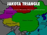
Jakota Triangle
THE JAKOTA TRIANGLE is an East Asian region comprising three countries: JAPAN, SOUTH KOREA, and TAIWAN. The concept originated with Harm de Blij and it has become popularized in the many editions of Geography: Realms, Regions and Concepts, first appearing in the 8th edition, published in 1997. The term triangle was inspired by the three-sided […]
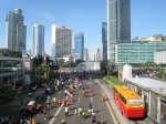
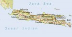
Jakarta
JAKARTA, LOCATED on the island of JAVA, is the capital of INDONESIA and serves as a gateway to the country. Java is located in a chain of islands, with SUMATRA to the northwest, Bali to the east, BORNEO to the northeast, and CHRISTMAS ISLAND to the south. It is the world's 13th-largest island. The huge […]
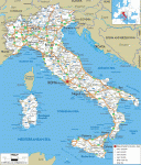
Italy
Area 116,306 square mi (301,230 square km) Population 61.34 million 2014 Capital Rome Highest Point 15,577 ft (4,748 m) Lowest Point 0 m GDP $2.144 trillion 2014 Primary Natural Resources limited natural gas, minerals, beef, arable land. ITALY, IN SOUTHWESTERN Europe, is a peninsula bordered by FRANCE to the northwest, SWITZERLAND to the north, SLOVENIA […]
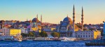
Istanbul
THE CITY OF ISTANBUL in TURKEY has one of the most interesting and important physical locations of any sity in the world, the crossroads of TRADE ROUTES by both water and land. It is the only city to straddle two continents, Europe and Asia, and has been at the center of regional commerce for nearly […]
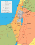
Israel
Area 8,019 square mi (20,770 square km) Population 8.215 million 2014 Capital Jerusalem Highest Point 3,974 ft (1,208 m) Lowest Point -1,338 ft (-408 m) GDP $304.2 billion 2014 Primary Natural Resources timber, potash, copper ore. THE STATE OF ISRAEL is located on the eastern shore of the MEDITERRANEAN SEA, bordering the Gaza Strip to […]
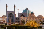
Isphahan
FOR THE LAST 900 years, Isphahan (Isfahan, Esfahan) has been the capital of the province of the same name in the center of the empire that was known as Persia, now IRAN. The city lies in a basin at an altitude of 5,150 ft (1,570 m) above sea level in the foothills of the ZAGROS […]
island
AN ISLAND IS A LANDMASS smaller than a continent surrounded by water. The largest islands are GREENLAND, NEW GUINEA, BORNEO, MADAGASCAR, Baffin Island, and SUMATRA. The smallest islands are a few square miles or kilometers. An extended line of islands is an island chain. A cluster of islands is an archipelago. Islands are of either […]
Islam
MOST RELIGIONS, such as Confucianism, Buddhism, Jainism, and Judaism have a geographic point or place of origin and remain largely focused upon that nexus. Some, such as Christianity and Islam, have engaged in specific efforts to proselytize and spread their faith, often as an integral part of trade. Among the significant geographic impacts of Islam […]
irrigation
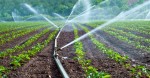
IRRIGATION IS THE application of water to crops in addition to what normal local precipitation supplies. It is primarily used in areas with less than 20 in (51 cm) of rain per year (semiarid or arid climates) or in areas of monsoon rains with long dry periods. Irrigation allows growth of nondryland crops in semi-arid […]
Irrawaddy River
THE IRRAWADDY is the chief river of MYANMAR, or Burma. It is formed from the confluence of the Mali and N'mai rivers far in the northern highlands on the borders with CHINA, and flows 1,350 mi (2,177 km) before entering the Andaman Sea (a section of the BAY OF BENGAL). The river's extensive DELTA begins […]
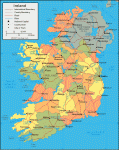
Ireland
Area 27,135 square mi (70,280 square km) Population 4.613 million 2014 Capital Dublin Highest Point 3,414 ft (1,041 m) Lowest Point 0 m GDP $245.9 billion 2014 Primary Natural Resources zinc, lead, natural gas, barite, copper, gypsum. THE REPUBLIC OF Ireland covers five-sixths of the island of Ireland and shares its only border with Northern […]
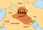
Iraq
Area 168,754 square mi (437,072 square km) Population 34.81 million 2014 Capital Baghdad Highest Point 11,847 ft (3,611 m) Lowest Point 0 m GDP $220.5 billion 2014 Primary Natural Resources petroleum, natural gas, phosphates. IRAQ IS A MIDDLE EASTERN country, bordering the PERSIAN GULF, between IRAN and KUWAIT. Iraq is also bordered by TURKEY, SYRIA, […]
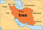
Iran
Area 636,296 square mi (1,648,000 square km) Population 78.14 million 2014 Capital Tehran Highest Point 18,605 ft (5,671 m) Lowest Point -91 ft (-28 m) GDP $415.3 billion 2014 Primary Natural Resources petroleum, natural gas, coal. IRAN IS A MIDDLE EASTERN country, bordering the Gulf of Oman, the PERSIAN GULF, and the CASPIAN SEA, between IRAQ […]
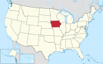
Iowa
IOWA IS A midwestern state in the north-central part of the UNITED STATES bordered on two sides by major rivers. To the east is the MISSISSIPPI that separates Iowa from ILLINOIS and WISCONSIN. In the west, the Missouri River separates it from NEBRASKA, while the Big Sioux River separates it from SOUTH DAKOTA from Sioux […]
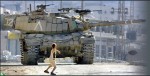
Intifada
INTIFADA IS THE name given to the popular uprising of the Palestinian population against the continuation of Israeli occupation of the West Bank and Gaza Strip. There have been two Intifadas, the first, essentially spontaneous and indigenous, began in December 1987 and continued sporadically until the early 1990s. The second Intifada began after the collapse […]
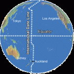
international date line
THE INTERNATIONAL date line (IDL) is the imaginary line on Earth slicing through the center of the PACIFIC OCEAN that separates two consecutive calendar days. Countries in the Eastern Hemisphere to the left of the line up to the Prime Meridian are always one day ahead of countries to the right of the line and […]
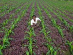
intercropping
THE CULTIVATION OF TWO or more crops in combination in the same field at the same time is known as intercropping. This is one of two types of multiple cropping, the other being sequential cropping, whereby two or more crops are grown in sequence in the same field. There are four types of intercropping: Mixed […]
insurgent state
INSURGENT STATE is a term that refers to the creation of a geographic area that not only claims independence from the larger state, but whose leaders and policies also seek to replace the existing political order and state, or to become independent. It is not a segment of the country that seeks independence (civil war). […]

Industrial Revolution
THE INDUSTRIAL Revolution is one of the most dramatic events in modern world history, an event which has more or less influenced all nations of the world in one form or another. The Industrial Revolution began in the late-18th century in England, UNITED KINGDOM, in a region of the country known as the West Midlands—the […]
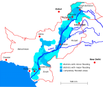
Indus River
THE INDUS RIVER in PAKISTAN flows 1,900 mi (3,000 km) from southwestern TIBET to the Arabian Sea. From the dawn of human culture, the Indus River has sustained societies along its banks; the earliest civilization that can be reliably distinguished is called the Indus Valley civilization (or Harappan). This sophisticated society is dated back to […]
Indonesia
Area 741,110 square mi (1,919,440 square km) Population 254.5 million 2014 Capital Jakarta Highest Point 16,502 ft (5,030 m) Lowest Point 0 m GDP $888.5 billion 2014 Primary Natural Resources petroleum, natural gas, nickel, copper. COMPOSED OF 17,000 islands, Indonesia is the world's sixth-largest nation and the world's largest archipelago, stretching over 5,000 mi (8,047 […]
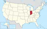
Indiana
KNOWN AS THE Hoosier State, the north central state of Indiana (“Land of Indians”) was formed from the Northwest Territory in 1800 and entered the Union in 1816 as the 19th state. Roughly rectangular in shape, Indiana is approximately 270 mi (434 km) north to south and 140 mi (225 km) east to west. The […]
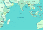
Indian Ocean
MEASURING approximately 26.5 million square mi (68.5 million square km), the Indian Ocean includes the Andaman Sea, ARABIAN SEA, BAY OF BENGAL, Flores Sea, Great Australian Bight, Gulf of Aden, Gulf of Oman, Java Sea, Mozambique Channel, PERSIAN GULF, RED SEA, Savu Sea, Straits of Malacca, Timor Sea, and other tributary water bodies. The ocean […]
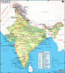
India
Area 1,284,215 square mi (3,287,590 square km) Population 1.295 billion 2014 Capital New Delhi Highest Point 28,201 ft (8,598 m) Lowest Point 0 m GDP $2.067 trillion 2014 Primary Natural Resources coal, iron ore, manganese, mica, bauxite. INDIA IS LOCATED in South Asia bordering the INDIAN OCEAN, ARABIAN SEA, and the BAY OF BENGAL in […]
imperialism
FEW TOPICS ARE MORE emotion-provoking than imperialism, which many consider to be a product of the 20th century and of Europeans. Nothing is further from the truth. By definition, imperialism is the act of imposing one's will (personal or national) on another culture or state to create an empire, or an empire is the consequence […]
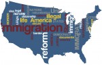
immigration
ALIENS OR NONCITIZENS who reside or seek to reside temporarily or permanently within the borders of a country are generally termed as immigrants. The term immigrant refers to someone who enters a country, while the word emigrant refers to someone who leaves a country. In the early times, the tendency was to look upon the […]
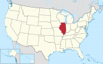
Illinois
ILLINOIS IS A midwestern state located in the northcentral part of the UNITED STATES. Lake MICHIGAN and INDIANA border the state in the east, while WISCONSIN borders the state in the north. KENTUCKY lies to the southeast, across the Ohio River, while the MISSISSIPPI RIVER separates the state from MISSOURI and IOWA in the west. […]
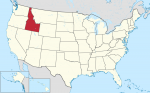
Idaho
IDAHO'S VAST areas of unspoiled beauty and natural wilderness give every reason for the 1,293,953 residents (2000) to know their home as the “Gem” state. Idaho is bounded by CANADA in the north, MONTANA and WYOMING in the east, UTAH and NEVADA in the south, and WASHINGTON and OREGON in the west. The capital and […]
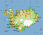
Iceland
Area 39,769 square mi (103,000 square km) Population 327,600 2014 Capital Reykjavik Highest Point 6,950 ft (2,119 m) Lowest Point 0 m GDP $17.07 billion 2014 Primary Natural Resources hydropower, geothermal heat. ICELAND IS A volcanic island lying on the Mid-Atlantic Rift 170 mi (280 km) southeast of GREENLAND and 500 mi (800 km) northwest […]
Ibn Battuta (1304–1377)
BORN IN TANGIER, MOROCCO, Muhammad ibn Abdullah ibn Battuta was a famous Arab traveler and writer who explored in Africa, Europe, and Asia. Ibn Battuta's journey began in North Africa in 1325 with travels that included visits to EGYPT, SYRIA, Mecca on the Arabian Peninsula, northeastern IRAN, southern IRAQ, the RED SEA, YEMEN, East Africa, […]
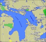
Huron, Lake
LAKE HURON IS ONE of the five Great Lakes and is named for the Hurons, a Native American people who once lived along its shores. Lake Huron covers 23,000 square mi (59,570 square km) and is 206 mi (332 km) long. At its greatest width, it is 193 mi (295 km) across. It lies at […]

Hunza
THE HUNZA VALLEY in north PAKISTAN is noted for two features: Burushaski, a language that appears to be unrelated to any other language in the world, and secondly, the myth of the health and longevity of its inhabitants, the Hunzakuts. This valley was the reputed location of novelist James Hilton's Shangri-La. The valley is located […]

Huntington, Ellsworth (1876–1947)
CONTEMPORARIES WERE impressed by the clarity of Ellsworth Huntington's style, the intensity of his reasoning, the simplicity of his grand theories, and his unique ability to generalize: “With devastating logic and sound scholarship, Ellsworth Huntington shows how climate, weather, geographical location, diet, health and heredity control the character of a nation—and determine its dominant or […]
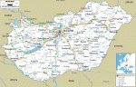
Hungary
Area 35,919 square mi (93,030 square km) Population 9.862 million 2014 Capital Budapest Highest Point 3,346 ft (1,014 m) Lowest Point 257 ft (78 m) GDP $137.1 billion 2014 Primary Natural Resources bauxite, coal, natural gas. HUNGARY IS UNIQUE among the nations of Europe in many ways: a relatively flat country among hillier neighbors, a […]
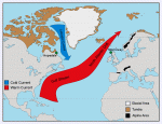
Humboldt Current
THE HUMBOLDT CURRENT, also known as the Peru Current, is an ocean current that flows along the western coast of South America, affecting the water and air temperatures of coastal CHILE and PERU. It is one of the largest ocean currents in the world, bringing cold water north from the South PACIFIC for thousands of […]

Humboldt, Alexander von (1769–1859)
ALEXANDER VON HUMBOLDT is significant to the study of geography because of the breadth of his scientific inquiries and knowledge and his ability to integrate these studies within larger works that were both scientifically advanced and appealing to a wider nonspecialist public. He was known as a natural scientist of the highest order, working to […]
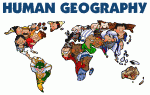
human geography
HUMAN GEOGRAPHY FOCUSES on interpreting and describing the various ways in which humans in all places and cultures adapt to and possibly modify their natural geographic environments. At the local or national scale, human geographers look at how economic, political, and cultural issues are related to spatial organization in different parts of the planet. How […]
human-environment relationships
THE ENVIRONMENTAL approach in geography, history, anthropology, psychology, and other spheres of humanitarian thought remains one of the most alluring and unequivocal since its origin in ancient times. At the beginning of the 21st century, interdisciplinary studies of cultural history using contemporary methods of instrumental analysis are often bringing scientists to the necessity of taking […]
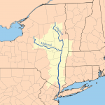
Hudson River
“THE RIVER THAT Flows Both Ways” is located between Lake Tear of the Clouds and the southern tip of Manhattan in NEW YORK. It flows 315 mi (507 km) and empties into the ATLANTIC OCEAN. Its low and high tides, along with its salty water, account for the river's bidirectional water flow. The Lower Hudson […]
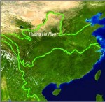
Huang (Yellow) River
THE YELLOW RIVER, called the Huang He by the Chinese, is the second longest river in CHINA reaching 5,500 km (3,000 mi), second only to the CHANGJIANG (Yangzi River). The regions to the north and south of the Huang River are called, respectively, the Hebei (north) and Henan (south). The chief tributaries of the Huang […]
horst
HORST IS THE German word for a high-nesting area for a bird, so the term infers a high elevation. Early geomorphologists fittingly applied the German word to a fault block mountain range. The faulting and vertical displacement is due to tension stresses in the crust. Tension causes crustal rock to spread apart and break to […]
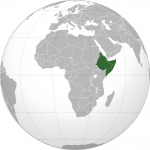
Horn of Africa
THE PENINSULA OF NORTHEAST Africa is called the Horn of Africa. It lies opposite of the southern Arabian Peninsula. This area is also known as the Somali Peninsula because within it lies the countries of SOMALIA and eastern ETHIOPIA. It is the easternmost extension of the African continent separating the Gulf of Aden from the INDIAN […]
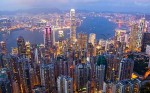
Hong Kong
HONG KONG IS A FORMER British colony that returned to the People's Republic of CHINA on June 30, 1997, and is now officially the Hong Kong Special Administrative Region. Hong Kong consists of the island of Hong Kong and about 200 islands and the New Territories that are on Kowloon Peninsula on the mainland. Hong […]
Honduras
Area 43,278 square mi (112,090 square km) Population 6,669,789 Capital Tegucigalpa Highest Point 9,416 ft (2,870 m) Lowest Point 0 m GDP per capita $2,600 Primary Natural Resources timber, gold, silver, copper, lead, zinc. Honduras is located right in the heart of Central America, sharing borders with EL SALVADOR, NICARAGUA, and GUATEMALA. Most of the […]

homeland security
AS DEFINED BY the executive branch of the U.S. government, homeland security is “a concerted national effort to prevent terrorist attacks within the United States, reduce America's vulnerability to terrorism, and minimize the damage and recover from attacks that do occur” (July 2002 National Strategy for Homeland Security, issued by President George W. Bush). In […]
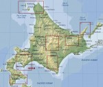
Hokkaido Island
NORTHERNMOST OF the four main islands of JAPAN, Hokkaido is surrounded by the Sea of Okhotsk to the north and east, the Sea of Japan to the west, and the PACIFIC OCEAN to the south. Its northern location and frigid ocean currents from the Sea of Okhotsk make Hokkaido's climate considerably colder and drier than […]
historical geography
GEOGRAPHERS SEEK TO understand the world by examining spatial relationships. The types of questions they might ask are: Why are things located where they are? How are places different from each other? How are places like each other? How are places interconnected with each other? How do people affect their natural environment and how does […]
hinterland
FROM THE GERMAN umland, a hinterland is inland territory behind and bordering a town on a coast or river, or the backcountry extending from an inland town. In both cases, the hinterland generally falls under the legal and economic jurisdiction of the same state to which the city belongs. The hinterland supplies a city with […]
Hindu Kush
HINDU KUSH (or Hindukush) is the main mountain range in the Central Asian state of AFGHANISTAN. Hindu Kush is the westernmost extension of the Pamir mountain, the Karakoram (K-2), and the western HIMALAYAS. The origin of the term Hindu Kush (which translates as “Hindu Killer” or “Killer of Hindus”) is a point of controversy among […]
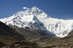
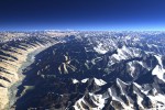
Himalayas
THE HIMALAYAN mountain region, located between INDIA and TIBET, has the world's highest peaks. It stretches from the INDUS RIVER in the west to the Brahamaputra in the east and has a length of 1,500 mi (2,414 km) and a width from 100 to 150 mi (161 to 241 km). Northwest of the Indus, the […]
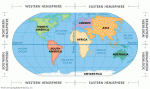
hemisphere
THE WORD hemisphere means “half a sphere.” In geography, the term refers to half the Earth, and the enclosing boundary line of a hemisphere is a great circle. A space traveler viewing the Earth from a great distance will see only half the earth, a hemispheric perspective. This is true because the Earth is a […]
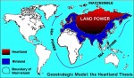
heartland
THE HEARTLAND THEORY was developed by Scottish geographer, Sir Halford J. MACKINDER. He read his paper “The Geographical Pivot of History” before the Royal Geographical Society in London in 1904, and soon afterward published his views on the influence of geography on politics in the Geographical Journal. Mackinder's argument introduced into POLITICAL GEOGRAPHY the view […]
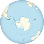
Heard and McDonald Islands
TWO OF THE MOST isolated spots on the globe, the Heard and McDonald Islands have only been visited a few times, and much remains to be discovered about them. The islands are located at the bottom of the world, where the INDIAN OCEAN meets the Antarctic seas, and have recently been declared a United Nations […]
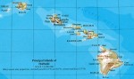
Hawaii
HAWAII IS a U.S. state located in the central PACIFIC OCEAN near the EQUATOR and consists of eight major islands: Hawaii, Maui, Kahoolawe, Lanai, Molokai, Oahu, Kauai, and Niihau; 129 smaller islands are also part of Hawaii. Hawaii is not the equivalent of the Hawaiian Islands or the Hawaiian Chain, which includes other islands, such […]
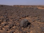
hammada
HAMMADA IS AN Arabic word used to describe “desert pavement.” The deserts of the world that have sand dunes capture the imagination, but many of the world's desert areas are bleak, stony deserts. Usually, the stony deserts are level plains that are virtually devoid of vegetation and also have very little, if any, soil. These deserts can have a relatively smooth, […]
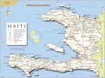
Haiti
Area 27,750 square mi (44,658 square km) Population 10.57 million 2014 Capital Port-au-Prince Highest Point 8,792 ft (2,680 m) Lowest Point 0 m GDP $8.713 billion 2014 Primary Natural Resources bauxite, copper, calcium carbonate, gold. HAITI IS LOCATED on the western third of the island of Hispaniola in the CARIBBEAN SEA. The country is mainly […]
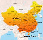
Hainan Island
THE SECOND-largest island (after TAIWAN) in CHINA with an area of 13,104 square mi (33,940 square km), Hainan Island is the most southerly province located in the South China Sea. The island is situated south of Guangdong province and west of VIETNAM. The topographic structure of the island resembles a staircase, with towering mountains in […]
Guyana
Area 76,772 square mi (196,850 square km) Population 763,900 2014 Capital Georgetown Highest Point 9,355 ft (2,835 m) Lowest Point 0 m GDP $3.228 billion 2014 Primary Natural Resources bauxite, gold, diamonds, hardwood. THE NAME Guyana possibly comes from a local native word meaning “land of water,” but it could also derive from the word […]
Gulf Stream
THE GULF STREAM, a relative newcomer on the geological scene, is an odd, fast-moving circulation of warm water that travels in an unfixed position, a few hundred miles north of FLORIDA, up the east coast of the UNITED STATES to Cape Hatteras, NORTH CAROLINA, then onto Nantucket Island, before kicking eastward across the ATLANTIC OCEAN […]
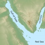
Gulf of Aqaba
THE GULF OF AQABA is the north arm of the RED SEA; it is bordered by ISRAEL, JORDAN, EGYPT, and SAUDI ARABIA. Created by seismic activity along the Afro-Syrian Rift, it is the northernmost extension of the Red Sea. It is a semi-enclosed water body that extends south some 111 mi (180 km) from Eilat […]
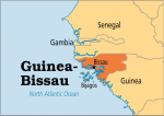
Guinea-Bissau
Area 13,942 square mi (36,120 square km) Capital Bissau Population 1.801 million (2014) Highest Point 984 ft (300 m) Lowest Point 0 m GDP $1.022 billion (2014) Primary Natural Resources fish, timber, phosphates, bauxite, petroleum. THE REPUBLIC OF Guinea-Bissau, commonly called Guinea-Bissau, is a tropical West African nation-state. The borders include the ATLANTIC OCEAN on […]
Guinea
Area 94,925 square mi (245,857 square km) Population 12.28 million (2014) Capital Conakry Highest Point 5,748 ft (1,752 m) Lowest Point 0 m GDP $6.624 billion (2014) Primary Natural Resources bauxite, iron ore, diamonds, precious metals. GUINEA IS LOCATED in the southwestern part of West Africa. It is bordered by GUINEA-BISSAU, SENEGAL, and MALI to […]
guerrilla base
A GUERRILLA BASE or base area is a physically secure geographic location used by political dissidents from which they can launch military attacks. Historically, such bases were local or national. In 2003, the process became global, with guerrilla bases of al-Qaeda staged in AFGHANISTAN, PAKISTAN, the PHILIPPINES, SUDAN, and possibly South America. Since guerrilla bases […]
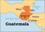
Guatemala
Area 67,661 square mi (108,890 square km) Population 16.02 million 2014 Capital Guatemala City Highest Point 13,815 ft (4,211 m) Lowest Point 0 m GDP $58.73 billion 2014 Primary Natural Resources petroleum, nickel, rare woods. THE REPUBLIC OF GUATEMALA is located in Central America and is bordered by the PACIFIC OCEAN, the Gulf of Honduras, […]
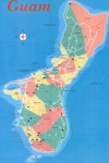
Guam
A U.S. TERRITORY, the island of Guam is one of the largest islands in the north PACIFIC OCEAN, located about three-quarters of the distance from HAWAII to the PHILIPPINES. Its harbor, one of the best in the world, underlies the importance the island has held for the last five centuries to foreign powers in the […]
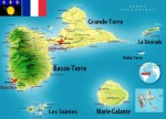
Guadeloupe
GUADELOUPE, IN THE CARIBBEAN SEA, is one of the four French overseas departments (similar to states in the UNITED STATES). Guadeloupe is also a French region. There are two main islands, Basse Terre and Grande Terre, separated by a strip of water called the Riviere Salee. Other outlying inhabited islands are dependencies, namely Saint Martin, […]
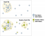
growth pole
GROWTH POLE REFERS to the concentration of highly innovative and technically advanced industries that stimulate economic development in linked businesses and industries. This concept was first introduced by Francois Perroux in 1950, was further sharpened in following publications, and finally evolved into an idea that came to take on a meaning rather different from the […]
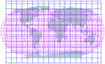
grid/graticule
THE EARTH IS NOT spherical but rather an ellipsoidal shape where the north and south poles are flattened and the equator bulges. This unique shape is called a geoid. In order to uniquely locate features on the Earth's surface, a reference system is required. An imaginary network of lines called a grid or graticule is […]
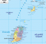
Grenada
Area 133 square mi (344 square km) Population 106,300 (2014) Capital Saint George's Highest Point 2,756 ft (840 m) Lowest Point 0 m GDP $882.2 million 2014 Primary Natural Resources timber, tropical fruit, agricultural products. GRENADA IS AN independent island country in the CARIBBEAN SEA. It is a member of the British Commonwealth. The country was in the news in 1983, […]
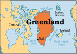
Greenland
ONE OF THE MOST northerly territories in the world is Greenland, located between the North ATLANTIC, the northeastern coasts of CANADA (Ellesmere and Baffin islands), and the ARCTIC OCEAN. More than two-thirds of the region lies above the ARCTIC CIRCLE. Greenland is technically considered part of North America, though ICELAND (usually considered part of Europe) […]
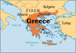
Greece
Area 51,012 square mi (130,800 square km) Capital Athens Population 10.96 million 2014 Highest Point 9,626 ft (2,917 m) Lowest Point 0 m GDP $237.6 billion 2014 Primary Natural Resources bauxite, lignite, magnesite, petroleum. FOR OVER 4,000 years, Greece has been at the crossroads of civilizations. The great empires of the Western and Eastern worlds […]
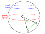
great circle
A GREAT CIRCLE IS defined as a direction line that forms a full circle. This is also called a true azimuth. A great circle divides the Earth into equal halves and on the idealized surface of the Earth, the shortest distance between two points lies along a great circle. The equator is a great circle, […]
Great Barrier Reef
THE GREAT BARRIER REEF, located on the northeast coast of AUSTRALIA, is comprised of the world's largest cluster of coral reefs. It is 1,250 mi (2,012 km) long; running along 10 mi (16 km) of the eastern Australia shore in the north to 100 mi (161 km) in the south. Its length is comparable to […]
grasslands
MANY DIFFERENT TYPES of ecosystems throughout the world are described as grasslands because they are dominated by species of grass with a range of other plant types as subordinates within the community. Grasslands occur at most latitudes and altitudes reflecting the wide range of environmental tolerances that characterize this huge taxonomic group of plants known […]
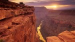
Grand Canyon
WITH DIMENSIONS of 277 mi (446 km) long and 18 mi (29 km) wide, the Grand Canyon is one of the most spectacular natural wonders of the world. Crafted by the Colorado River, it is an enduring and unchallenged natural symbol of North America. At its present size of 1,904 square mi (4,911 square km), […]
Grand Canal (China)
THE GRAND CANAL is one of the wonders of the world. Built in the 7th century by CHINA's Sui Dynasty, it stretches about 1,100 mi (1,800 km) across eastern China—about the same distance as MIAMI, FLORIDA, to NEW YORK CITY, or LOS ANGELES, CALIFORNIA, to Vancouver, CANADA. The canal was built to transport rice and […]
Golan Heights
THE GOLAN HEIGHTS (in Arabic, Al-Jaw-lan) is a hilly region in southwest SYRIA, bordering nearby regions of LEBANON and JORDAN, with a highest point of 7,297 ft (2,224 m). The area is one of the most heavily disputed areas in the history of the 20th century. When the state of ISRAEL emerged after the vote […]
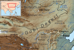
Gobi Desert
THE 650,000-square-mi (1,600,000-square-km) Gobi is the largest desert in CHINA and MONGOLIA; both the Taklamakan Desert (in XINJIANG) and the Changtang Desert (in TIBET and Qinghai) are only half the size. Only the SAHARA is bigger than the Gobi among the world's deserts. The Gobi separates the Republic of Mongolia from the province of Inner […]
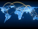
globalization
GLOBALIZATION IS A term that is used quite frequently but whose meaning remains obscure. One definition of globalization is that is a process of complex interconnections between societies, cultures, institutions, and individuals that takes place worldwide. It also describes the increased mobility of goods, services, labor, technology, and capital. Although globalization is not a new […]
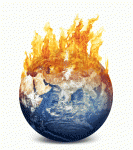
global warming
GLOBAL WARMING IS an increase in the temperature of the Earth due to an increase in greenhouse gases that reduce natural cooling. Periodically, the natural changes in the Earth's climate have produced increases and decreases in average temperature and the changes have altered the climate of the Earth. The current debate over global warming centers around […]
glaciation
THE ACTION OF GLACIERS has made a huge difference in the appearance of the Earth's surface. Changes in the land from the action of glaciers is called glaciation. A glacier is a moving mass of ice, air, water, rock and sediment. Glaciers flow very slowly with gravity created by their own mass. During the last […]
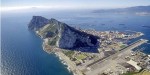
Gibraltar
GIBRALTAR IS AN overseas territory of the UNITED KINGDOM. Historically known as one of the Pillars of Hercules, the Rock of Gibraltar has guarded the entrance to the Mediterranean world since the beginning of Western civilization. Held by Great Britain since 1704 (formally since 1713), the peninsula remains one of Britain's last overseas territories, with little […]
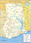
Ghana
Area 92,090 square mi (238,500 square km) Population 26.44 million (2014) Capital Accra Highest Point 2,904 ft (885 m) Lowest Point 0 m GDP $38.65 billion (2014) Primary Natural Resources gold, bauxite, diamonds, hydropower. GHANA IS LOCATED in west-central Africa and is bordered by COTE D'IVOIRE to the west, TOGO to the east, and BURKINA […]
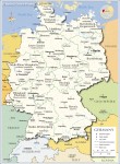
Germany
Area 137,845 square mi (357,021 square km) Population 80.89 million 2014 Capital Berlin Highest Point 9,721 ft (2,963 m) Lowest Point -11 ft (-3.54 m) GDP $3.853 trillion 2014 Primary Natural Resources iron ore, coal, potash, timber, lignite. THE FEDERAL REPUBLIC of Germany is one of the largest countries and has the largest population in […]
geostrophic winds
GEOSTROPHIC WINDS blow above the friction layer of the Earth, balanced between pressure gradient forces and the Coriolis force. Geo, meaning “Earth,” and strophic, or “turning,” refer to the Coriolis force of the Earth's rotation. The Coriolis force causes wind to bend, eventually equalizing with the pressure gradient force. Geostrophic winds blow aloft and parallel to […]
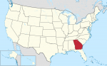
Georgia (U.S. state)
Georgia (U.S. state)ONE OF THE 13 original American colonies, the state of Georgia was founded by General James Oglethorpe under a charter signed by King George II of England in June 1732. Georgia is bounded on the east by the ATLANTIC OCEAN and SOUTH CAROLINA, on the west by ALABAMA, on the south by FLORIDA, […]
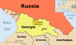
Georgia
Area 43,310 square mi (69,700 square km) Population 4.504 million 2014 Capital T'bilisi Highest Point 17,064 ft (5,201 m) Lowest Point 0 m GDP $16.53 billion 2014 Primary Natural Resources forests, hydropower, manganese, iron ore, copper. LOCATED IN THE REGION known as the Caucasus or Caucasia, Georgia is a small country, about the size of […]
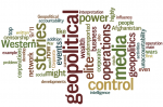
geopolitics
GEOPOLITICS IS POLITICS taking place in regard to geographical circumstances, territorial relations and aspirations of political entities. It derives from the spatial settings of place as well as from territoriality as a universal dimension of human (and animal) behavior. While the spectrum of geopolitical action is very wide, it is never just derived from “geographic […]
geomorphology
GEOMORPHOLOGY IS the study of landforms. Landforms are surface expressions of rocks, as are various features made by rivers, groundwater, waves and currents, winds, glaciers, and corals. Landforms come in all shapes and sizes. A DELTA, PLATEAU, VOLCANO, sinkhole, and beach are all landforms. Geomorphologists are geologists and physical geographers who specialize in the study […]
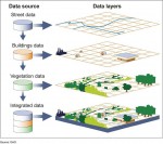
geographic information system
GEOGRAPHIC INFORMATION systems are widely known by their abbreviation, GIS. The most popular definition of GIS is: a computer-assisted system for the acquisition, storage, analysis, and display of geographic data. Conceptually, GIS has been defined as the digital representation of the landscape of a place (a site, a region, a planet), structured to support analysis. A […]