Plate Tectonics
On the globes and maps we've seen since childhood, the outline of each continent is so unique that we would never mistake one continent for another. But why are no two continents even closely alike? The answer lies in the long formation history of the Earth's surface features, which is driven by the movement of lithospheric plates. The science of lithospheric […]
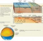
Major Relief Features of the Earth’s Surface
THE LITHOSPHERE AND ASTHENOSPHERE The major relief features of the Earth—its continents and ocean basins—were created by the movements of plates on the surface of the Earth. Geologists use the term lithosphere to describe an outer Earth shell of rigid, brittle rock, including the crust and also the cooler, upper part of the mantle (Figure 11.15). The lithosphere ranges in thickness […]
Minerals and Rocks of the Earth’s Crust
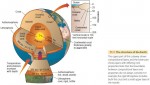
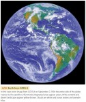
What lies deep within the Earth? Our planet has a central core with several layers, or shells, surrounding it. The densest matter is at the center, and each layer above it is increasingly less dense. THE EARTH'S INTERIOR Our planet is almost spherical, with a radius of approximately 6400 km (about 4000 mi). Its central core is about 3500 km […]
The Global Scope of Soils
How soils are distributed around the world helps to determine the quality of environments of the globe. That's because soil fertility, along with the availability of fresh water, is a basic measure of the ability of an environmental region to produce food for human consumption. We classify soils according to a system developed by scientists of the U.S. Natural Resources Conservation Service, […]
Soil Development
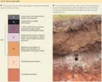
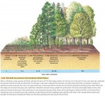
How do soils develop their distinctive characteristics? Let's turn to the processes that form soils and soil layers. SOIL HORIZONS Most soils have distinctive horizontal layers that differ in physical composition, chemical composition, organic content, or structure (Figure 10.12). We call these layers soil horizons. They develop through interactions between climate, living organisms, and the land surface, over time. Horizons usually […]
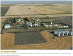
The Nature of the Soil
This chapter is devoted to soil systems. Soil is the uppermost layer of the land surface that plants use and depend on for nutrients, water, and physical support. Soils can vary greatly from continent to continent, from region to region, and even from field to field. This is because they are influenced by factors and processes that can vary widely from […]
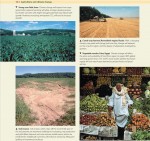
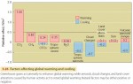
Global Change and Agriculture
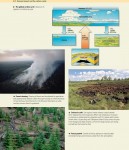
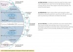
For the remainder of the twenty-first century, and probably well beyond, our global climate will change. The Earth will become warmer, especially in mid- and high latitudes. Most areas will have more precipitation, although higher temperatures will often bring more summer drought stress. Extreme events—heavy rainfalls and high winds—will be more frequent. How will global climate change impact agriculture? (Figure 10.1) In […]
Zanzibar
Zanzibar, an island state in the Indian Ocean, lies about 30 miles off the coast of East Africa. Long an Arab stronghold, it became a British colony in the late 1800s. Zanzibar gained its independence in 1963 and the next year joined Tanganyika in forming the United Republic of TANZANIA. Geography Zanzibar consists of two main islands, Unguja (also […]
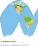
Mapping Global Land Cover by Satellite
Imagine yourself as an astronaut living on an orbiting space station, watching the Earth turn underneath you. One of the first things that would strike you about the land surface is its color and how it changes from place to place and time to time. Deserts are in shades of brown, dotted with white salty playas and the black spots and streaks of recent volcanic […]
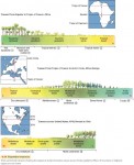
Climate and Altitude Gradients
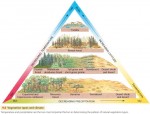
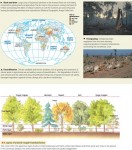
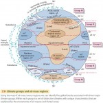
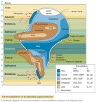
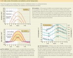
CLIMATE GRADIENTS AND BIOME TYPES As we have seen, biomes and formation classes change along with climate. Figure 9.34 shows three continental transects that illustrate this principle. The upper transect stretches from the Equator to the Tropic of Cancer in Africa. Across this region, climate ranges through all four low-latitude climates: wet equatorial, monsoon and trade-wind coastal, wet-dry tropical , […]
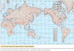
Desert and Tundra Biomes
DESERT BIOME The desert biome includes several formation classes that are transitional from grassland and savanna biomes into vegetation of the arid desert. Our map of the desert biome (Figure 9.28) recognizes two basic formation classes: semidesert and dry desert. Semidesert is a transitional formation class found in a wide latitude range—from the tropical zone to the midlatitude zone. It is […]
Savanna and Grassland Biomes
SAVANNA BIOME The savanna biome is usually associated with the tropical wet-dry climate 3 of Africa and South America. Its vegetation ranges from woodland to grassland. In savanna woodland, the trees are spaced rather widely apart because there is not enough soil moisture during the dry season to support a full tree cover. The open spacing lets a dense lower layer […]
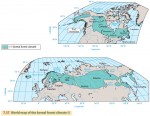
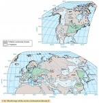
Forest Biome
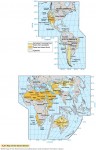
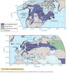
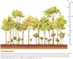
Within the forest biome, we can recognize six major formations: low-latitude rainforest, monsoon forest, subtropical evergreen forest, midlatitude deciduous forest, needleleaf forest, and sclerophyll forest. Ecologists sometimes recognize three principal types of forest as separate biomes, based on their widespread nature and occurrence in different latitude belts: low-latitude rainforest, midlatitude deciduous and evergreen forest, and boreal forest. LOW-LATITUDE RAINFOREST Low-latitude rainforest, found in […]
Terrestrial Ecosystems — The Biomes
For humans, ecosystems are great natural factories producing food, fiber, fuel, and structural material. These useful products are manufactured by organisms using energy from the Sun, and we harvest that energy by using these ecosystem products. The products and productivity of ecosystems depend on their climate. Where temperature and rainfall cycles permit, ecosystems provide a rich bounty. Where temperature or rainfall cycles restrict […]
Natural Vegetation
Over the last few thousand years, human societies have come to dominate much of the land area of our planet. We've changed the natural vegetation—sometimes drastically—of many regions. What exactly do we mean by natural vegetation? Natural vegetation is a plant cover that develops with little or no human interference. It is subject to natural forces, storms, or fires that […]
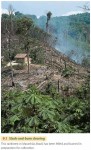
Exploitation of the Low-Latitude Rainforest Ecosystem
Many of the world's equatorial and tropical regions are home to the rainforest ecosystem. This ecosystem is perhaps the most diverse on Earth, possessing more species of plants and animals than any other. Very large tracts of rainforest still exist in South America, south Asia, and some parts of Africa. Ecologists regard this ecosystem as a genetic reservoir of many species […]
Biodiversity
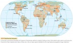
Today, global biodiversity—the variety of biological life on Earth—is rapidly decreasing. Two out of every five species on the planet that have been assessed by scientists face extinction, according to the International Union for Conservation of Nature and Natural Resources (Figure 8.37). Our species, Homo sapiens, has ushered in a wave of extinctions unlike any that has been seen for millions of years. In the last […]
Historical Biogeography
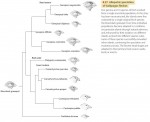
Thus far, we've looked at ecological processes that produce biogeographic patterns at local and regional spatial scales. We now turn to patterns at continental and global scales that develop over longer time periods. Historical biogeography focuses on how these spatial distribution patterns arise over space and time through four key processes: evolution, speciation, extinction, and dispersal. EVOLUTION An astonishing number of […]
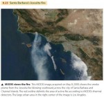
Remote Sensing of Fires
Wildfires occur frequently on the Earth's land surface, and biomass burning has important effects on both local and global ecosystems. Biomass burns inefficiently, releasing not only carbon dioxide and water, but also a number of other greenhouse gases that absorb outgoing longwave radiation and enhance the greenhouse effect. Aerosols are another by-product of inefficient combustion that can effect atmospheric processes. Burning mobilizes such nutrients as nitrogen, phosphorus, and sulfur […]
Ecological Succession
Plant and animal communities change through time. Walk through the country and you'll see patches of vegetation in many stages of development—from open, cultivated fields through grassy shrublands to forests. Clear lakes gradually fill with sediment and become bogs. We call these changes—in which biotic communities succeed one another on the way to a stable end point—ecological succession. In general, succession forms the most complex community of organisms possible, […]
Ecological Biogeography
We've seen how energy and matter move through ecosystems. But if we want to fully understand ecosystems, we'll also need to look at ecological biogeography, which examines the distribution patterns of plants and animals from the viewpoint of their physiological needs. That is, we must examine how the individual organisms of an ecosystem interact with their environment. From fungi digesting organic matter […]
Energy and Matter Flow in Ecosystems
This chapter is the first of two chapters that look at biogeography. Biogeography focuses on the distribution of plants and animals—the biota—over the Earth. It identifies and describes the processes that influence plant and animal distribution patterns. Ecological biogeography looks at how the distribution patterns of organisms are affected by the environment. Historical biogeography focuses on how spatial distribution patterns of organisms arise […]
Human Impact on the Carbon Cycle
Carbon is an element that is abundant at the Earth's surface and is also essential for life. Carbon cycles continuously among the land surface, atmosphere, and ocean in many complex pathways. However, these flows are now strongly influenced by human activity. The most important human impact on the carbon cycle is the burning of fossil fuels, which releases carbon dioxide (CO2) into […]
High-Latitude Climates (Group III)
By and large, the high-latitude climates are climates of the northern hemisphere, occupying the northern subarctic and arctic latitude zones. But they also extend southward into the midlatitude zone as far south as about the 47th parallel in eastern North America and eastern Asia. One of these, the ice sheet climate, is present in both hemispheres in the polar zones. The […]
Midlatitude Climates (Group II)
The midlatitude climates almost fully occupy the land areas of the midlatitude zone and a large proportion of the subtropical latitude zone. They also extend into the subarctic latitude zone, along the western fringe of Europe, reaching to the 60th parallel. Unlike the lowlatitude climates, which are about equally distributed between northern and southern hemispheres, nearly all of the midlatitude climate area […]

Low-Latitude Climates (Group I)
The low-latitude climates lie for the most part between the Tropics of Cancer and Capricorn, occupying all of the equatorial zone (10° N to 10° S), most of the tropical zone (10–15° N and S), and part of the subtropical zone. The low-latitude climate regions include the equatorial trough of the intertropical convergence zone (ITCZ), the belt of tropical easterlies (northeast and […]
Climate Classification
Mean monthly values of air temperature and precipitation can describe the climate of a weather station and its nearby region quite accurately. To study climates from a global viewpoint, climatologists classify these values into distinct climate types. This classification requires developing a set of rules to use in examining monthly temperature and precipitation values. By applying the rules, a climatologist can use […]
Temperature and Precipitation Regimes
Many parts of the world show distinctive patterns of monthly temperature and precipitation, usually related to latitude and location. These patterns are referred to as regimes of temperature and precipitation. TEMPERATURE REGIMES Figure 7.5 shows annual cycles of air temperature for different temperature regimes. The equatorial regime (Douala, Cameroon, 4° N) is uniformly very warm, with temperatures close to 27°C (81°F) […]
Factors Controlling Climate
Climate is the average weather of a region. The primary driving force for weather is the flow of solar energy received by the Earth and atmosphere. Because that energy flow varies on daily cycles with the planet's rotation and on annual cycles with its revolution in orbit, temperature and precipitation also vary on daily and annual cycles. However, climate includes […]
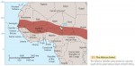
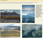
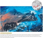
Drought in the African Sahel
One of the Earth's more distinctive climates is the wetdry tropical climate . Here, the weather is largely dry for much of the year, but there is a rainy season of a few months duration in which most of the annual rainfall occurs. Precipitation during the wet season is quite variable, ranging from little or none to torrential rainfalls that produce […]
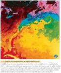
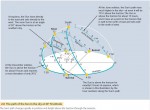
Poleward Transport of Heat and Moisture
As we saw in Chapter 5, the general circulation of the atmosphere and oceans is driven by the difference in solar heating between low and high latitudes. This general circulation, combined with jet stream disturbances in the midlatitudes, serves to redistribute heat and moisture from the Equator to the poles in the process of poleward heat transport. Figure 6.30 shows the various mechanisms by which this […]
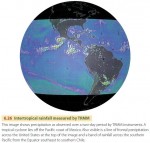
The Tropical Rainfall Monitoring Mission
In November of 1997, NASA and the Japanese Space Agency launched a joint satellite mission with the goal of monitoring rainfall in the tropical and equatorial regions of the world—the Tropical Rainfall Monitoring Mission (TRMM). Its operational objective is to provide more information about where and when intertropical convective precipitation occurs, particularly over oceans, which are not monitored by weather stations and rain gauges. The mission is also designed […]
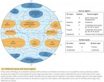
Tropical and Equatorial Weather Systems
So far, we have discussed weather systems of the midlatitudes and poleward. Weather systems of the tropical and equatorial zones show some basic differences from those of the midlatitudes. Upper-air winds are often weak, so air-mass movement is slow and gradual. Air masses are warm and moist, and different air masses tend to have similar characteristics, so fronts are not as clearly defined. Without the […]
Midlatitude Anticyclones and Cyclones
Air masses are set in motion by wind systems—typically, masses of air moving in a spiral. Air can spiral inward and converge in a cyclone, or spiral outward and diverge in an anticyclone. Most types of cyclones and anticyclones are large features spanning hundreds to thousands of kilometers that move slowly across the Earth's surface, bringing changes in the weather as […]
Air Masses
We know that the Earth's atmosphere is in constant motion, driven by the planet's rotation and its uneven heating by the Sun. The horizontal motion of the wind moves air from one place to another, allowing air to acquire characteristics of temperature and humidity in one region and then carry those characteristics into another region. In addition, as winds at the […]
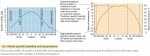
Cloud Cover, Precipitation, and Global Warming
Clouds are so common we don't think much about them. But they can have a large impact on climate. How would global climate be influenced by an increase in clouds and precipitation? Global temperatures have been rising over the last 20 years. Satellite data show a rise in temperature of the global ocean surface of about 1°C (1.8°F) over the past […]
Ocean Circulation
Just as there is a circulation pattern to the atmosphere, there is also a circulation pattern to the oceans that it is driven by differences in density and pressure acting along with the Coriolis force. Pressure differences are created in the water when the ocean is heated unequally, because warm water is less dense than cold water. These pressure differences induce […]
Winds Aloft
We've looked at airflows at or near the Earth's surface, including both local and global wind patterns. But how does air move at the higher levels of the troposphere? Like air near the surface, winds at upper levels of the atmosphere move in response to pressure gradients and are influenced by the Coriolis effect. How do pressure gradients arise at […]
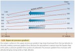
Global Wind and Pressure Patterns
For simplicity, let's begin by looking at surface winds and pressure patterns on an ideal Earth that does not have oceans and continents, or seasons (Figure 5.16). Hadley cells are key to an understanding of the wind patterns on our ideal Earth. These form because the Equator is heated more strongly by the Sun than other places, creating thermal circulations. Air […]
Cyclones and Anticyclones
THE CORIOLIS EFFECT We have seen that the pressure gradient force moves air from high pressure to low pressure. For sea and land breezes, which are local in nature, this pushes wind in about the same direction as the pressure gradient. But on global scales, the direction of air motion is more complicated. The difference is caused by the Earth's rotation, through the Coriolis effect (Figure 5.13). The Coriolis effect […]
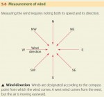
Local Wind Patterns
Wind is defined as air moving horizontally over the Earth's surface. Air motions can also be vertical, but these are known by other terms, such as updrafts or downdrafts. Wind direction is identified by the direction from which the wind comes—a west wind blows from west to east, for example. Like all motion, the movement of wind is defined by its […]
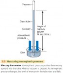
Atmospheric Pressure
We live at the bottom of a vast ocean of air—the Earth's atmosphere. Like the water in the ocean, the air in the atmosphere is constantly pressing on the Earth's surface beneath it and on everything that it surrounds. The atmosphere exerts pressure because gravity pulls the gas molecules of the air toward the Earth. Gravity is an attraction among all […]
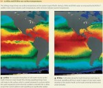
El Nino
At irregular intervals of about three to eight years, a remarkable disturbance of ocean and atmosphere occurs in the equatorial Pacific region—El Nino. Its name comes from Peruvian fishermen, who refer to the Corriente del Nino or the “Current of the Christ Child,” to describe an invasion of warm surface water once every few years around Christmas time that greatly depletes their […]
Air Quality
Most people living in or near urban areas have experienced air pollution first hand. Perhaps you've felt your eyes sting or your throat tickle as you drive an urban freeway. Or you've noticed black dust on window sills or window screens and realized that you are breathing in that dust as well. AIR POLLUTANTS Air pollution is largely the result […]
Tornadoes
A tornado is a small but intense vortex in which air spirals at tremendous speed. It is associated with thunderstorms spawned by fronts in the midlatitudes of North America. Tornadoes can also occur inside tropical cyclones (hurricanes). TORNADO CHARACTERISTICS A tornado, seen in Figure 4.32, appears as a dark funnel cloud hanging from the base of a dense cumulonimbus cloud. At […]
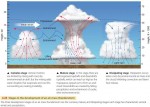
Thunderstorms
A thunderstorm is any storm that produces thunder and lightning. At the same time, thunderstorms can also produce high winds, hail, and tornadoes. They are typically associated with cumulus clouds that indicate the presence of rising, unstable air. It is this rising motion that produces the characteristic rainfall and lightning that accompany thunderstorms. Thunderstorms can range from fairly isolated, short-lived storms, sometimes called […]
Types of Precipitation
Precipitation consists of liquid water drops and solid crystals that fall from the atmosphere and reach the ground. This precipitation can take several different forms. RAIN Rain is precipitation that reaches the ground as liquid water. Raindrops can form in warm clouds as liquid water, which through collisions can coalesce with other drops and grow large enough to fall to Earth. […]
Precipitation
FORMATION OF PRECIPITATION Clouds are the source of precipitation—the process that provides the fresh water essential for most forms of terrestrial life. Precipitation can form in two ways. In warm clouds, fine water droplets condense, collide, and coalesce into larger and larger droplets that can fall as rain. In colder clouds, ice crystals form and grow in a cloud that contains a mixture of […]
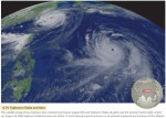
Observing Clouds from GOES
Some of the most familiar images of Earth acquired by satellite instruments are those of the Geostationary Operational Environmental Satellite (GOES) system. Images from the GOES series of satellites have been in constant use since 1974. The primary mission of the GOES series is to view cloud patterns and track weather systems by providing frequent images of the Earth from a consistent viewpoint in space provided by […]
Clouds
Clouds are frequent features of the atmosphere. Views of the Earth from space show that clouds cover about half of the Earth at any given time. Low clouds reflect solar energy, thus cooling the Earth–atmosphere system, while high clouds absorb outgoing longwave radiation, thus warming the Earth– atmosphere system. One of the most familiar roles of clouds, however, is in producing precipitation. Clouds […]
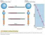
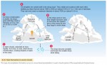
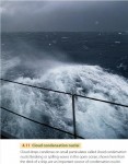
The Adiabatic Process
What makes the water vapor in the air turn into liquid or solid particles that can fall to the Earth? The answer is that the air is naturally cooled. When air cools to the dew point, the air is saturated with water. Think about extracting water from a moist sponge. To release the water, you have to squeeze the sponge—that […]
Humidity
Blistering summer heat waves can be deadly, with the elderly and the ill at most risk. However, even healthy young people need to be careful, especially in hot, humid weather. High humidity slows the evaporation of perspiration from our bodies, reducing its cooling effect. Clearly, it is not only the temperature of the air that controls how hot weather affects us—the amount of water vapor in […]
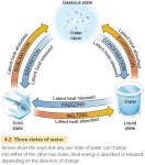
Water in the Environment
In this chapter, we focus on water in the air, both as vapor and as liquid and solid water. Precipitation is the fall of liquid or solid water from the atmosphere that reaches the Earth's land or ocean surface. It forms when moist air is cooled, causing water vapor to form liquid droplets or solid ice particles. If cooling is […]
Acid Deposition
Perhaps you've heard about acid rain killing fish and poisoning trees. Acid rain is part of the phenomenon of acid deposition. It's made up of raindrops that have been acidified by air pollutants. Fossil fuel burning releases sulfur dioxide (SO2) and nitric oxide (NO2) into the air. The SO2 and NO2 readily combine with oxygen and water in the presence of […]
Global Warming and the Greenhouse Effect
The Earth is getting warmer. In February 2007, the Intergovernmental Panel on Climate Change (IPCC), a United Nations-sponsored group of more than 2000 scientists, issued a report saying that global warming is “unequivocal”. Is this recent warming an effect of human activity? In 1995 the IPCC concluded that human activity has probably caused climatic warming by increasing the concentration of greenhouse gases […]
World Patterns of Air Temperature
We have learned some important principles about air temperatures in this chapter. Surface type (urban or rural), elevation, latitude, daily and annual insolation cycles, and location (maritime or continental) can all influence air temperatures. Now let's put all these together and see how they affect world air temperature patterns. First, we need a quick explanation of air temperature maps. Figure 3.21 shows a set of isotherms—lines connecting locations […]
Daily and Annual Cycles of Air Temperature
Let's turn to how, and why, air temperatures vary around the world. Insolation from the Sun varies across the globe, depending on latitude and season. Net radiation at a given place is positive during the day, as the surface gains heat from the Sun's rays. At night, the flow of incoming shortwave radiation stops, but the Earth continues to radiate longwave […]
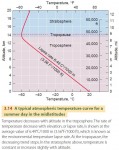
Temperature Structure of the Atmosphere
In general, the air is cooler at higher altitudes. Remember from Chapter 2 that most incoming solar radiation passes through the atmosphere and is absorbed by the Earth's surface. The atmosphere is then warmed at the surface by latent and sensible heat flows. So it makes sense that, in general, air farther from the Earth's surface will be cooler. We call […]
Surface and Air Temperature
This chapter focuses on air temperature—that is, the temperature of the air as observed at 1.2 m (4 ft) above the ground surface. Air temperature conditions many aspects of human life, from the clothing we wear to the fuel costs we pay. Air temperature and air temperature cycles also act to select the plants and animals that make up the biological landscape of a region. […]
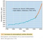
Carbon Dioxide — On the Increase
One of the most important factors affecting air temperatures over the long run is the greenhouse effect, in which atmospheric gases absorb outgoing longwave radiation and reradiate a portion back to the surface. This makes surface temperatures warmer. Apart from water vapor, carbon dioxide gas plays the largest role in the greenhouse effect and CO2 concentration is increasing. In the centuries before […]
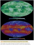
CERES—Clouds and the Earth’s Radiant Energy System
The Earth's global radiation balance is the primary determinant of long-term surface temperature, which is of great importance to life on Earth. Because this balance can be affected by human activities, such as converting forests to pasturelands or releasing greenhouse gases into the atmosphere, it is important to monitor the Earth's radiation budget over time as accurately as possible. For nearly 20 years, NASA has studied the […]
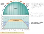
Net Radiation, Latitude, and the Energy Balance
Although the energy budgets of the Earth's surface and atmosphere are in balance overall, their budgets do not have to balance at each particular place on the Earth, nor do they have to balance at all times. At night, for example, there is no incoming radiation from the Sun, yet the Earth's surface and atmosphere still emit out going radiation. Net […]
The Global Energy System
Human activity around the globe has changed the planet's surface cover and added carbon dioxide to the atmosphere. Have we irrevocably shifted the balance of energy flows? Is our Earth absorbing more solar energy and becoming warmer? Or is it absorbing less and becoming cooler? If we want to understand human impact on the Earth–atmosphere system, then we need to examine the […]
Sensible Heat and Latent Heat Transfer
The most familiar form of heat storage and transport is known as sensible heat—it's what you feel when you touch a warm object. When we use a thermometer, we are measuring sensible heat. Sensible heat transfer moves heat from warmer to colder objects by conduction when they are in direct contact. Sensible heat is also transferred by convection when a fluid such as the atmosphere […]
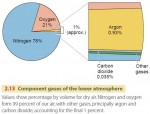
Composition of the Atmosphere
The Earth is surrounded by air—a mixture of various gases that reaches up to a height of many kilometers. This envelope of air makes up our atmosphere (Figure 2.13). It is held in place by the Earth's gravity. Almost all the atmosphere (97 percent) lies within 30 km (19 mi) of the Earth's surface. The upper limit of the atmosphere is […]
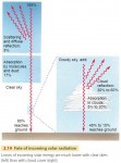
Insolation over the Globe
Most natural phenomena on the Earth's surface—from the downhill flow of a river to the movement of a sand dune to the growth of a forest—are powered by the Sun, either directly or indirectly. It is the power source for wind, waves, weather, rivers, and ocean currents, as we will see here and in later chapters. Although the flow of solar […]
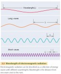
Electromagnetic Radiation
All surfaces—from the fiery Sun in the sky to the skin covering our bodies—constantly emit radiation. Very hot objects, such as the Sun or a light bulb filament, give off radiation that is nearly all in the form of light. Most of this energy is visible light, which we perceive with the colors of the rainbow, but the Sun also […]
The Ozone Layer— Shield to Life
High above the Earth's surface lies an atmospheric layer rich in ozone—a form of oxygen in which three oxygen atoms are bonded together (O3). Ozone is a highly reactive gas that can be toxic to life and damaging to materials, but high in the atmosphere it serves an essential purpose—sheltering life on the Earth's surface from powerful ultraviolet radiation emitted by […]
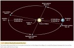
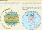
The Earth’s Revolution around the Sun
So far, we have discussed the importance of the Earth's rotation on its axis. But what about the Earth's movement as it orbits the Sun? We refer to this motion as the Earth's revolution around the Sun. The Earth takes 365.242 days to travel around the Sun—almost a quarter of a day longer than the calendar year of 365 days. […]
Global Time
There's an old Canadian joke that goes, “Repent! The world will end at midnight! or 12:30 A.M. in Newfoundland.” It's humorous because independent-minded Newfoundlers use a time zone that is a half-hour ahead of the other Canadian maritime provinces. It highlights the fact that one single instant across the world—no matter how cataclysmic—is simultaneously labeled by different times in different local places. […]
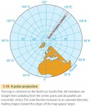
Map Projections
The problem of how to best display the Earth's surface has puzzled cartographers, or mapmakers, throughout history. The oldest maps were limited by a lack of knowledge of the world, rather than by difficulties caused by the Earth's curvature. They tended to represent political or religious views rather than geographic reality. Ancient Greek maps from the sixth century B.C. show the world […]
The Geographic Grid
It is impossible to lay a flat sheet of paper over a sphere without creasing, folding, or cutting it—as you know if you have tried to gift-wrap a ball. This simple fact has caused mapmakers problems for centuries. Because the Earth's surface is curved, we cannot divide it into a rectangular grid anymore than we could smoothly wrap a globe in […]
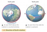
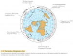
Earth Rotation
The Earth spins slowly on its axis —an imaginary straight line through its center and poles—a motion we refer to as rotation. We define a solar day by one complete rotation, and for centuries we have chosen to divide the solar day into exactly 24 hours. The North and South Poles are defined as the two points on the Earth's […]
The Shape of the Earth
As we all learn early in school, the Earth's shape is very close to a sphere. Pictures taken from space by astronauts and by orbiting satellites also show us that the Earth is a ball rotating in space. Today it seems almost nonsensical that many of our ancestors thought the world was flat. But to ancient sailors voyaging across the […]
Earth Visualization Tools
Within the last few years, remote sensing, geographic information systems, and GPS technology have been integrated into new and exciting Internet tools for visualizing the Earth. Google Earth and World Wind are outstanding examples of these Earth visualization tools. GOOGLE EARTH Google Earth is a program for personal computers that allows users to roam the Earth's surface at will and zoom […]
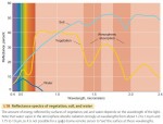
Remote Sensing for Physical Geography
Another important geographic technique for acquiring spatial information is remote sensing. This term refers to gathering information from great distances and over broad areas, usually through instruments mounted on aircraft or orbiting spacecraft. These instruments, or remote sensors, measure electromagnetic radiation coming from the Earth's surface and atmosphere as received at the aircraft or spacecraft platform. The data acquired by remote sensors are […]
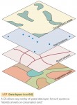
Geographic Information Systems
Maps, like books, are very useful devices for storing information, but they have limitations. Recent advances in computing capability have enabled geographers to develop a powerful new tool to work with spatial data—the geographic information system (GIS). A GIS is a computer-based system for acquiring, processing, storing, querying, creating, analyzing, and displaying spatial data. Geographic information systems have allowed geographers, geologists, geophysicists, ecologists, planners, […]
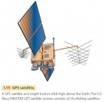
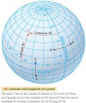
The Global Positioning System
The latitude and longitude coordinates of a point on the Earth's surface describe its position exactly. But how are those coordinates determined? For the last few hundred years, we have known how to use the position of the stars in the sky coupled with an accurate clock to determine the latitude and longitude of any point. Linked with advances in mapping […]
Maps and Cartography
Cartography is the field of geography concerned with making maps. A map is a paper representation of space showing point, line, or area data—that is, locations, connections, and regions. It typically displays a set of characteristics or features of the Earth's surface that are positioned on the map in much the same way that they occur on the surface. The map's […]
Tools in Physical Geography
Geographers use a number of specialized tools to examine, explore, and interact with spatial data. One of the oldest tools is the map—a paper representation of space showing where things are. While maps will never go out of style, computers have enhanced our ability to store, retrieve, and analyze spatial data through the development of geographic information systems (GIS). Acquiring geographic information […]
Physical Geography, Environment, and Global Change
Physical geography is concerned with the natural world around us—in short, with the human environment. Because natural processes are constantly active, the Earth's environments are constantly changing. Sometimes the changes are slow and subtle, as when crustal plates move over geologic time to create continents and ocean basins. At other times, the changes are rapid, as when hurricane winds flatten vast areas […]
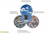
Spheres, Systems, and Cycles
As a part of your introduction to physical geography, it will be useful to take a look at the big picture and examine some ideas that arch over all of physical geography—that is, spheres, systems, and cycles. The first of these ideas is that of the four great physical realms, or spheres of Earth—atmosphere, lithosphere, hydrosphere, and biosphere. These realms […]
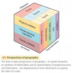
Introducing Geography
What is geography? Put simply, geography is the study of the evolving character and organization of the Earth’s surface. It is about how, why, and where human and natural activities occur and how these activities are interconnected. What makes geography different from other disciplines? Geography adopts a unique set of perspectives to analyze the world and its human and natural phenomena. These […]
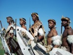
Zulu
The Zulu, a large ethnic group in SOUTH AFRICA, are based in Natal Province on the country's eastern coast. They speak a BANTU language closely related to that of the XHOSA. Originally one of many small societies in the region, the Zulu grew into a powerful nation in the 1800s. Traditionally the Zulu were farmers, growing millet, a kind […]
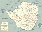
Republic of Zimbabwe
POPULATION: 15.25 million (2014) AREA: 150,803 sq. mi. (390,580 sq. km) LANGUAGES: English (official); Shona, Ndebele NATIONAL CURRENCY: Zimbabwe dollar PRINCIPAL RELIGIONS: Syncretic (part traditional, part Christian) 50%, Christian 25%, Traditional 24%, Other 1% CITIES: Harare (capital), 1,752,000 (2001 est.); Bulawayo, Gweru, Mutare, Kwekwe, Kadoma, Hwange, Masvingo ANNUAL RAINFALL: Varies from 40 in. (1,020 mm) in Eastern Highlands to 15 in. (400 mm) in […]
Zara Ya’iqob
Ruled 1434–1468 Emperor of Ethiopia Zara Ya'Iqob, a powerful and intelligent Ethiopian ruler, was a devout Christian. He sometimes took strong measures to make sure that Christianity remained the dominant religion in ETHIOPIA. The son of emperor Dawit of Ethiopia, Zara Ya'iqob was educated at his father's royal court. When his father died and his brother became emperor, Zara Ya'iqob […]
Republic of Zambia
POPULATION: 15.72 million (2014) AREA: 290,586 sq. mi. (752,618 sq. km) LANGUAGES: English (official); Bemba, Tonga, Lozi, Lunda, Nyanja, others NATIONAL CURRENCY: Zambian kwacha PRINCIPAL RELIGIONS: Christian 50–75%, Hindu and Muslim 24–49%, Traditional 1% CITIES: Lusaka (capital), 1,640,000 (2001 est.); Kitwe, Ndola, Chingola, Mufulira, Luanshya, Kabwe, Livingstone ANNUAL RAINFALL: Varies from 50 in. (1,400 mm) in the north to 20 in. (510 mm) in […]
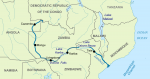
Zambezi River
The Zambezi River is the fourth longest in Africa, after the NILE, CONGO, and NIGER rivers. It runs for 1,678 miles across the southern part of the continent, from ZAMBIA through ANGOLA, NAMIBIA, BOTSWANA, ZIMBABWE, and MOZAMBIQUE before emptying into the Indian Ocean. Along the river's course are many distinctive natural and human-made features. For 354 miles from its source […]
Yoruba
The term Yoruba refers to several western African peoples, including the Ife, Ibadan, and Egba. Europeans called all these groups Yoruba because they shared commons features of language, political organization, and culture. However, when referring to themselves, the Yoruba tend to use the names of their individual groups. Located mainly in southwestern NIGERIA, BENIN, and northern TOGO, the Yoruba number more […]

Xhosa
The Xhosa, an ethnic group of SOUTH AFRICA, mostly live in Eastern Cape province in the southeastern part of the country. Although some groups farther north speak Xhosa, they are not considered part of the cluster of Xhosa chiefdoms. The language of the Xhosa reveals clues about their history and their connections with other groups. It is very closely […]
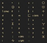
Writing Systems
Although there are thousands of African LANGUAGES, most of the systems used to record them originated outside the continent. A number of factors determined the writing system chosen for each language, including which system seemed to fit the language best and various social and political reasons. Types of Writing Systems There are two basic types of writing systems: logographic and […]
World Wars I and II
Although Africa did not play a significant role in either World War I or World War II, the wars had a major impact on the continent. Africans participated in fighting, and African colonies supplied the European powers with food and raw materials. A number of colonies changed hands as a result of the wars, and the wartime struggles inspired Africans […]
Women in Africa
During the second half of the 1900s, the rise of women's movements around the world brought new attention to the role of women in Africa. Long overlooked by historians and scholars, African women have begun to gain recognition for their contributions to economic and political life as well as to the home and family. Still, African women generally do not […]
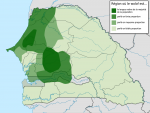
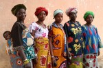
Wolof
The Wolof, a western African people, live in the nations of SENEGAL and GAMBIA, mainly in villages between the Senegal and Gambia Rivers. The Wolof number about 4 million. Their language, also called Wolof, is widely spoken in Senegal. According to tradition, individual Wolof villages combined to create an empire with its center in northwest Senegal sometime in the […]
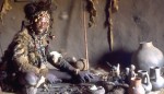
Witchcraft and Sorcery
Many Africans view both misfortune and spectacular success as unnatural and believe that witchcraft or sorcery causes such events. Individuals referred to as witches or sorcerers—and by various local African names—are said to use secret, magical forces to hurt other people, to bring great success to themselves, or to maintain a powerful position in society. Their activities, which are usually […]
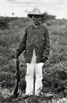
Witbooi, Hendrik
1830–1905 Nama leader Hendrik Witbooi, chief of the Nama people, was a religious leader who fought against German rule in southern Africa. Trained as a carpenter, he became a deacon, an official of the Christian church. Witbooi was born in Pella, a region south of the Orange River, between the nations of NAMIBIA and SOUTH AFRICA. After nearly dying […]
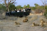
Wildlife and Game Parks
Elephants passing in slow, stately groups, lions lazing under a tree in the noonday heat, shaggy mountain gorillas feeding in a clearing in the rain forest—these images instantly suggest Africa, which is famous around the world for the amount and variety of its wildlife. Yet the rapid growth of Africa's human population, accompanied by the use of ever more land […]
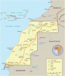
Western Sahara
POPULATION: 261,794 (2014) AREA: 97,000 sq. mi. (252,000 sq. km) LANGUAGES: Arabic (official); Berber dialects NATIONAL CURRENCY: Moroccan dirham PRINCIPAL RELIGION: Muslim CITIES: El-Aaiun (Laayoune), Cabo Bojador, Bu Craa, Smara (Semara), Ad Dakhla ANNUAL RAINFALL: Less than 2 in. (50 mm) ECONOMY: GDP per capita: N/A PRINCIPAL PRODUCTS AND EXPORTS: Agricultural: fish Manufacturing: handicrafts Mining: phosphates GOVERNMENT: Claimed and administered by Morocco since 1979, […]
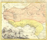
West African Trading Settlements
Europeans began setting up trading posts on the coast of western Africa in the mid-1400s. The result was a string of European settlements from present day SENEGAL to the coast of modern NIGERIA. Centuries later these trading posts became the bases for European colonial claims in western Africa. European traders referred to sections of the coast by the main […]

Warfare
Warfare has played a role in almost every society in human history. As societies grow larger and more complex, the nature of conflict and the motivation behind it tend to change. In Africa, where warfare once consisted of quick raids made by small bands of people, these changes are evident. Modern African nations have permanent professional armies backed by powerful […]