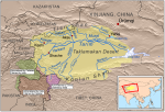
Tarim Basin
THE TARIM BASIN designates a major river and great basin located in the Uighur Autonomous Region of Sinkiang of extreme northwestern CHINA, north of the TIBETAN PLATEAU. Tarim also connotes the bank of a river that flows into a lake or that becomes indistinguishable from desert sands. The basin occupies nearly one half of Sinkiang and is encircled by the TIAN […]
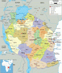
Tanzania
Area 364,900 square mi (945,087 square km) Population 51.82 million (2014) Capital Dar es Salaam Highest Point 19,340 ft (5,895 m) Lowest Point 0 m GDP $48.06 billion (2014) Primary Natural Resources coal, diamonds, gemstones, gold. TANZANIA IS A LARGE COUNTRY located on the INDIAN OCEAN in eastern Africa. It was formerly known as Tanganyika. In 1964, […]
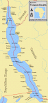
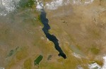
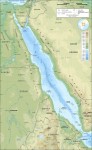
Tanganika, Lake
LAKE TANGANIKA IS IN east-central Africa in the Great Rift Valley at an elevation of 2,534 ft (772 m). It is very deep and narrow in typical rift formation with mountains rising out of the lake. According to the Center for Great Lakes Studies, Lake Tanganika is the seventh-largest lake in the world when ranked by area and is the […]
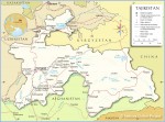
Tajikistan
Area 55,251 square mi (143,100 square km) Population 8.296 million 2014 Capital Dushanbe Highest Point 24,591 ft (7,495 m) Lowest Point 984 ft (300 m) GDP $9.242 billion 2014 Primary Natural Resources hydropower, uranium, mercury. LANDLOCKED AND MOUNTAINOUS, Tajikistan gained its independence in 1991 following the dissolution of the Soviet Union. The Republic of Tajikistan was engulfed in […]
Taiwan
Area 13,891 square mi (35,980 square km) Population 22,603,001 Capital Taipei Highest Point Yu Shan 12,962 ft (3,952 m) Lowest Point 0 m GDP per capita $18,000 Primary Natural Resources coal, natural gas, limestone, marble. TAIWAN IS A mountainous island in the SOUTH CHINA SEA, with the Philippine Sea to the southeast, Luzon Strait to the south, […]

taiga
THE FORESTS OF THE world occur in several climatic zones, which range from the subpolar to tropical regions. The taiga is the name given to the forests that border the tundra meadows and dwarf shrublands of polar latitudes where annual temperature regimes prohibit the growth of trees. These forests are dominated by coniferous species. The name derives from the Russian word […]
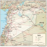
Syria
Area 71,498 square mi (185,180 square km) Population 22.16 million 2014 Capital Damascus Highest Point 9,232 ft (2,814 m) Lowest Point -656 ft (-200 m) GDP $40.41 billion 2007 Primary Natural Resources oil, gas, phosphates, asphalt. THE SYRIAN ARAB Republic (“Al-Jumhria Al-Arabia Al-Suria” in Arabic) is a Middle Eastern country located at the southwestern edge of the […]
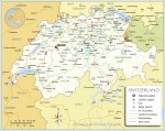
Switzerland
Area 15,942 square mi (41,290 square km) Population 8.190 million 2014 Capital Bern Highest Point 15,153 ft (4,634 m) Lowest Point 637 ft (195 m) GDP $701.0 billion 2014 Primary Natural Resources hydropower, timber, salt. THE SWISS CONFEDERATION is a LANDLOCKED country that borders FRANCE to the west, GERMANY to the north, LIECHTENSTEIN and AUSTRIA to the […]
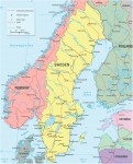
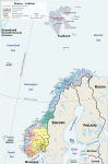
Sweden
Area 173,732 square mi (499,964 square km) Capital Stockholm Population 9.690 million 2014 Highest Point 6,024 ft (2,111 m) Lowest Point 0 m GDP $571.1 billion 2014 Primary Natural Resources zinc, iron ore, lead, copper, silver, timber. SWEDEN IS ONE of the four Scandinavian countries of northern Europe. Like its neighbors NORWAY and FINLAND, Sweden is a […]
Swaziland
Area 6,704 square mi (17,363 square km) Population 1.269 million (2014) Capital Lobamba Highest Point 6,108 ft (1,862 m) Lowest Point 68 ft (21 m) GDP $4.413 billion (2014) Primary Natural Resources asbestos, coal, clay, cassiterite. THIS TINY, LANDLOCKED, southern African monarchy is surrounded by the Republic of SOUTH AFRICA on three sides and MOZAMBIQUE on the […]
Svalbard and Jan Mayen
Two territories of the kingdom of NORWAY, Svalbard and Jan Mayen are outposts for hunting, mining, and scientific activity far to the north of most human settlement. The islands are located north and northwest of Norway, within the southern limits of Arctic sea ice— the northernmost point of Svalbard is within a 620 mi (1,000 km) of the North Pole. Svalbard […]
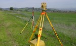
surveys, land
IT IS POSSIBLE THAT from our very earliest origins, modern humans have had an interest in putting things into perspective; being able to say where things are. As the Earth's population grew and hunting grounds became more removed from the places people lived, there was a need to be able to tell others how to get there. Or perhaps on meeting […]
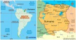
Suriname
Area 63,039 square mi (163,270 square km) Population 538,200 2014 Capital Paramaribo Highest Point 4,059 ft (1,230 m) Lowest Point -6.6 ft (-2 m) GDP $5.210 billion 2014 Primary Natural Resources timber, hydropower, fish, kaolin. SURINAME IS THE SMALLEST independent country in South America. Known formerly as Dutch Guiana, it has had a troubled history since independence […]
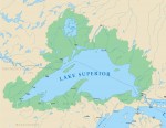
Superior, Lake
LAKE SUPERIOR IS THE coldest, deepest and largest of the Great Lakes, a group of lakes located along the border between the UNITED STATES and CANADA. Moreover, Lake Superior has the largest surface area of any freshwater lake, worldwide, at 31,700 square mi (82,100 square km). To put its size into perspective, its waters could, according to the Great Lakes Information Network […]
sunspots
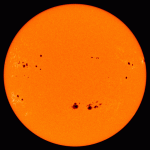
SUNSPOTS ARE DARK, roughly circular features on the solar photosphere. They appear dark because they are cooler than surrounding parts of the photosphere— 7,000 degrees F (4,000 degrees C) as compared to 11,000 degrees F (6,000 degrees C). Most sunspots are about 20,000 mi (32,000 km) across, wider than the Earth's diameter, with a dark central umbra and a lighter penumbra. Sunspots […]
Sumatra
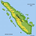
SUMATRA IS IN Southeast Asia and is the sixthlargest island in the world. It is part of the country of INDONESIA. The island was largely under Dutch control beginning in the 17th century but joined newly independent Indonesia in 1949. Sumatra runs northwest–southeast for about 1,060 mi (1,700 km). The island sits on the southern edge of the massive Eurasia lithospheric […]
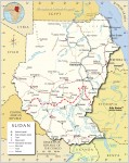
Sudan
Area 967,499 square mi (2,505,810 square km) Population 39.35 million (2014) Capital Khartoum Highest Point 10,500 ft (3,187 m) Lowest Point 0 m GDP $73.81 billion (2014) Primary Natural Resources petroleum, iron ore, copper, chromium. BORDERED BY THE CENTRAL AFRICAN REPUBLIC, CHAD, Democratic Republic of the CONGO, EGYPT, ERITREA, ETHIOPIA, KENYA, LIBYA, and UGANDA, Sudan is Africa's largest […]
strait
A STRAIT IS A narrow waterway connecting two larger bodies of water. These narrow passageways are sometimes the only way to travel from one body of water to another. They have been important to humans throughout history. Some of the most important straits include Bering Strait, Cook Strait, the Strait of GIBRALTAR and the Bosporus. The Bering Strait is located between […]
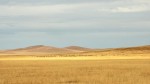
steppe
MANY OF THE WORLD'S wide-open spaces, particularly in eastern Europe and central Asia, are considered to be steppe. A steppe is a plain mostly without trees, dominated by short grasses. This distinguishes a steppe from a PRAIRIE, which is usually qualified as having tall grasses. The word steppe is originally Russian, and it is in RUSSIA, UKRAINE, and KAZAKHSTAN where most steppes […]
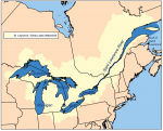
St. Lawrence River
THE ST. LAWRENCE RIVER (in French, “fleuve Saint-Laurent”) was formed at the end of the last ice age. It is a 1,900-mi (3,058-km) west-to-east, middle latitude river connecting the five Great Lakes with the ATLANTIC OCEAN. The French called the river Riviere du Canada until the early 1600s, but fleuve connotes a river that runs to the sea, a more appropriate […]
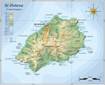
St. Helena Island
SAINT HELENA IS AN ISLAND in the South ATLANTIC OCEAN between Africa and South America. The capital is Jamestown. The Crown Colony of Saint Helena is formed by the island of St. Helena, the islands of Tristan da Cunha (more than 1,300 mi or 2,000 km from St. Helena) and ASCENSION (more than 750 mi or 1,200 km from St. Helena). […]
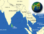
Sri Lanka
Area 25,332 square mi (65,610 square km) Population 20.64 million 2014 Capital Colombo Highest Point 8,280 ft (2,524 m) Lowest Point 0 m GDP $78.82 billion 2014 Primary Natural Resources limestone, graphite, mineral sands. GEOLOGICALLY, THE ISLAND of Sri Lanka is considered a southerly extension of peninsular INDIA's Deccan region and was clearly part of the peninsula […]
spatial interaction
SPATIAL INTERACTION IS A dynamic flow process from one location to another. It is a general concept that may refer to the movement of human beings such as intraurban commuters or intercontinental migrants, but may also refer to traffic in goods such as raw materials or to flows of intangibles such as information. While the origin of the term may […]
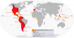
Spanish Empire
THE SPANISH EMPIRE designates the whole of territories that were conquered and ruled by SPAIN as a result of exploration and colonial expansion initiated in the 15th century. This expansion turned Spain into the first transcontinental superpower during the 16th and 17th centuries and helped shape much of the modern world. Built on military might and naval ingenuity, and maintained by trade […]
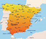
Spain
Area 194,897 square mi (504,782 square km) Population 46.40 million 2014 Capital Madrid Highest Point 12,191 ft (3,718 m) Lowest Point 0 m GDP $1.381 trillion 2014 Primary Natural Resources minerals, coal, lignite, iron ore, uranium. SPAIN IS A COUNTRY located in southwestern Europe, occupying with PORTUGAL the Iberian Peninsula. Spain also borders FRANCE and ANDORRA, and […]
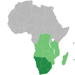
Southern African Development Community
IN 1980, NINE FRONTLINE southern African countries came together as the South African Development Coordination Conference (SADCC) to promote economic stability, increase interdependence, mitigate poverty, and battle the issue of apartheid in SOUTH AFRICA. In 1992, SADCC became the Southern African Development Community (SADC). By 1997, SADC had grown to 14 nations, including South Africa, where apartheid had been abolished. The geography of the […]
South Georgia and South Sandwich Islands
SOUTH GEORGIA and the South Sandwich Islands are two island formations at the southern extremities of the ATLANTIC OCEAN, not far from the Antarctic Peninsula that juts out from ANTARCTICA, 1,000 mi (1,600 km) to the south. Mostly consisting of steep mountains and ice, they have never had an indigenous population, but are instead known for one of the most numerous and […]
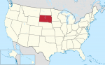
South Dakota
SOUTH DAKOTA, IN THE American Midwest, is the 17th largest state at 77,121 square mi (199,742 square km), but is small in population (just 754,844 people ranking it as 46th largest in population). Accordingly, South Dakota is a very sparsely populated state, with just under 10 people per square mile. The landscape of South Dakota varies from mainly rolling hills and […]
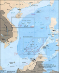
South China Sea
THE SOUTH CHINA Sea covers an area of 1.35million square mi (3.5 million square km) bordered by he People's Republic of CHINA, the Republic of China (TAIWAN), the PHILIPPINES, MALAYSIA, BRUNEI, INDONESIA, SINGAPORE, THAILAND, CAMBODIA, and VIETNAM. The South China Sea is a marginal sea, which means that it is part of the PACIFIC OCEAN but at the same time separated from […]
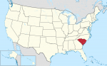
South Carolina
KNOWN AS THE Palmetto State, South Carolina was named for Kings Charles I and Charles II of England. This small state, which was one of the 13 original colonies, covers an area that extends from the ATLANTIC OCEAN to the APPALACHIAN MOUNTAINS. South Carolina is bounded on the north by NORTH CAROLINA, on the east and southeast by the Atlantic Ocean, […]
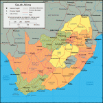
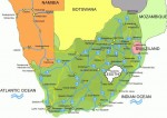
South Africa
Area 470,886 square mi (1,219,912 square km) Capital Pretoria Population 54.00 million (2014) Highest Point 11,181 ft (3,408 m) Lowest Point 0 m GDP $350.1 billion (2014) Primary Natural Resources gold, chromium, diamonds, platinum. OFFICIALLY called the Republic of South Africa, the country is a semiarid subtropical state located on the southernmost tip of Africa. […]
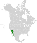
Sonoran Desert
THE SONORAN DESERT, an arid region of western North America, covers an area of 120,000 square mi (311,000 square km) in southwestern ARIZONA and southeastern CALIFORNIA, most of Baja California, and the western half of the state of Sonora, MEXICO. It is one of the largest and hottest deserts in North America and has two primary subdivisions, the Colorado and Yuma […]
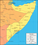
Somalia
Area 246,333 square mi (638,000 square km) Population 10.52 million (2014) Capital Mogadishu Highest Point 7,927 ft (2,416 m) Lowest Point 0 m GDP $5.707 billion (2014) Primary Natural Resources banana, sugarcane, cotton, corn, sorghum. SOMALIA OCCUPIES a strategic location along Africa's northeast coast at the southern approaches to BAB EL MANDEB and the route […]
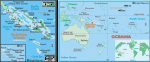
Solomon Islands
Area 10,985 square mi (28,450 square km) Population 572,200 2014 Capital Honiara Highest Point 8,028 ft (2,447 m) Lowest Point 0 m GDP $1.158 billion 2014 Primary Natural Resources fish, forest products, gold, bauxite. THE SOLOMON ISLANDS form an archipelago lying east of PAPUA NEW GUINEA, between the Solomon Sea and the South PACIFIC OCEAN. The country […]
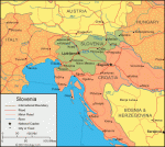
Slovenia
Area 7,906 square mi (20,273 square km) Population 2.062 million 2014 Capital Ljubljana Highest Point 9,396 ft (2,864 m) Lowest Point 0 m GDP $49.49 billion 2014 Primary Natural Resources lignite coal, lead, zinc, mercury, uranium. SLOVENIA IS LOCATED in Central Europe on the ADRIATIC SEA between AUSTRIA and CROATIA. The country's transitional area lies between the […]
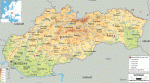
Slovakia
Area 18,859 square mi (48,845 square km) Population 5.419 million 2014 Capital Bratislava Highest Point 8,682 ft (2,655 m) Lowest Point 308 ft (94 m) GDP $100.2 billion 2014 Primary Natural Resources brown coal, lignite, iron ore. THE SLOVAK REPUBLIC or Slovakia is one of Europe's landlocked countries. Most of the country is rugged and mountainous, although […]
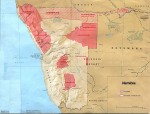
Skeleton Coast
THE SKELETON COAST is part of Africa's southwestern coastline. It runs from NAMIBIA's Cape Cross north to the Kunene River. Much of the plant, insect, and animal life here has adapted to a continued shortage of fresh water because most of the coast is part of the Namib Desert. Many species have unique ways to harvest water from morning fogs, helping […]
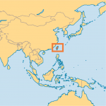
Singapore
Area 430.4 square mi (692.7 square km) Population 5.470 million 2014 Capital Singapore Highest Point 545 ft (166 m) Lowest Point 0 m GDP $307.9 billion 2014 Primary Natural Resources rubber, copra, fruit, vegetables, orchids, poultry. THE REPUBLIC OF Singapore consists of a main island and a group of 58 islets. It is situated in Southeast Asia, […]
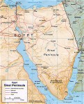
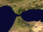
Sinai Peninsula
THE SINAI PENINSULA (in Arabic, the Shibh Jazirat Sina) is the eastern extension of EGYPT onto the continent of Asia (Egypt being mainly in Africa), bordering on the country of ISRAEL. The western boundary of the peninsula is formed by the Gulf of Suez and the Suez Canal, while it is separated from SAUDI ARABIA and JORDAN to the east by […]
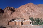
Sinai, Mount
LOCATED IN EGYPT on the SINAI PENINSULA, Mount Sinai has a height of 8,651 ft (2,640 m) and is known locally as Gebel Musa (Mountain of Moses). This granite mountain has long been associated with the area described in the Judeo-Christian Holy Scriptures as the setting where God revealed himself to Moses in a burning bush (Mount Horeb) and later provided […]
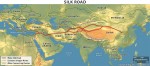
Silk Road
BETWEEN MESOPOTAMIA and CHINA stretched Central Asia, large, barren, hostile—a wasteland. Through this vast area, the one link that allowed the two civilizations to trade with each other was the loosely defined cluster of trails known as the Silk Road. Even today, the Silk Road runs through one of the harshest desert environments in the world, with little water or vegetation or […]
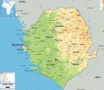
Sierra Leone
Area 27,699 square mi (71,740 square km) Population 6.316 million (2014) Capital Freetown Highest Point 6,390 ft (1,948 m) Lowest Point 0 m GDP $4.838 billion (2014) Primary Natural Resources diamonds, gold, titanium ore, bauxite. LOCATED ALONG the north ATLANTIC OCEAN in western Africa, Sierra Leone borders the Republic of GUINEA and LIBERIA. Most of the country's […]
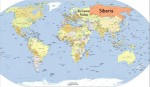
Siberia
SIBERIA, INCLUDING the Russian Far East, covers 4.9 million square mi (12.8 million square km), an area that is three-fourths of the Russian Federation or onethird larger than the UNITED STATES and one-fourth larger than CANADA. Siberia stretches from the URALS in the west over 3,000 mi (5,000 km) to the PACIFIC OCEAN in the east. It has borders with KAZAKHSTAN, MONGOLIA, […]
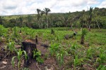
shifting cultivation
OF THE MANY different types of agriculture that exist worldwide, shifting cultivation is today most common in forested tropical and subtropical regions. It was once much more widespread in areas where permanent agricultural systems now exist, such as the temperate and Mediterranean zones, as agriculture emerged from hunting and gathering and spread from centers of origin in the Near and Far East. […]
shield
A SHIELD IS A large, tectonically inactive mass of Precambrian crystalline rock that underlies most of a continent. (Another name for a shield is craton.) A shield's rocks are igneous and metamorphic in origin and contain some of the oldest rocks on Earth. In zones of tectonic plate convergence, mountain systems that are actively building often mark the edges of shields. […]
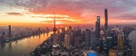
Shanghai
SHANGHAI IS CHINA's “second city,” and is a leader in the economic transformation of 21st-century China. Developed in the 19th century as imperial China's main outlet to the West, the city became one of the world's greatest marketplaces, as well as a sophisticated cultural center known as the Paris of the east. But it has also been labeled the New York […]
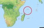
Seychelles
Map Page 1116 Area 177.5 square mi (455 square km) Population 91,530 (2014) Capital Victoria Highest Point 2,986 ft (905 m) Lowest Point 0 m GDP $1.423 billion (2014) Primary Natural Resources fish, copra, cinnamon trees. AS A RESULT OF competing colonial claims for dominance in the INDIAN OCEAN, the island republic of the Seychelles displays an intriguing mixture of indigenous, French, and […]
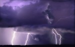
severe weather
IN THE UNITED STATES, severe weather is defined as a tornado, winds greater than 58 mi per hour (93 km per hour) or hail greater than .75 in (1.9 cm) in diameter. Other countries sometimes include heavy precipitation or a large amount of lightning in their definitions of severe weather. Severe weather is usually considered to come from thunderstorms but other storms, […]
service industries
SERVICES HAVE become a driving force in the global economy and the rise of the “new economy” amplifies this trend. However, for a long time, services were viewed as nonproductive activities. This situation was also justified in terms of services as invisible and intangible inputs to other material products that were largely supplied on an individual basis rather than in an integrated, […]
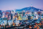
Seoul
AS THE MODERN capital of South KOREA, Seoul has a varied and vibrant character that reflects an ancient heritage as well as rebuilding and urban development in the post-World War II period. It ranks as the fifthlargest city in the world and has a population of some 10.8 million. It is situated in the Han River basin near the coast in […]
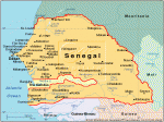
Senegal
Area 75,749 square mi (196,190 square km) Population 14.67 million (2014) Capital Dakar Highest Point 581 ft (177 m) Lowest Point 0 m GDP $15.66 billion (2014) Primary Natural Resources fish, phosphates, iron ore, natural gas. SENEGAL IS A FLAT, low-lying arid country located on the westernmost cape of Africa. Bounded by the ATLANTIC OCEAN, MAURITANIA, MALI, […]
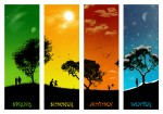
seasons
A GREAT DEAL OF the variation that exists in the Earth's physical phenomena is caused by the revolution and the ROTATION of the earth. The rotation of the Earth on its axis every 24 hours and the revolution of the earth around the sun every 365 days regulate the amount of electromagnetic energy received by the Earth's surface. Another factor which […]
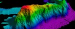
seamounts
SEAMOUNTS ARE MOUNTAINS more than 3,281 ft (1,000 m) high that rise from the seafloor and do not break the water's surface. Some seamounts occur thousands of meters beneath the ocean surface, while others are only dozens of feet from the surface. Seamounts vary in form as well—seamounts whose tops have been truncated by wave action resemble volcanic cones. Some seamounts are […]
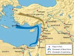
Sea Peoples
SEA PEOPLES ARE one of the populations of the ancient world who vigorously shaped the cultural landscapes in the eastern Mediterranean and adjacent lands. Sea Peoples were active from EGYPT to GREECE and as far as Sardinia and Corsica, and they reached the apex of their activity around 1200 B.C.E. They were a people or clans of seafarers who invaded eastern Anatolia, […]
Sea of Azov
THE SEA OF AZOV is an arm of the BLACK SEA, extending from the mouth of the River Don to the Kerch Strait. It covers 14,520 square mi (37,230 square km) and is 226 mi (365 km) east to west, and 110 mi (175 km) north to south. RUSSIA borders the sea to the east, with UKRAINE to the north […]
scale
SCALE IS A FUNDAMENTAL component of geographic events and processes. Climate change occurs at global scales, while human diseases such as measles occur at essentially local and regional scales. Many geographic processes also occur across multiple scales, and more important, some processes behave differently at various scales. Consequently, an explicit statement of scale is required to understand and compare these geographic processes. One […]

Sauer, Carl O. (1889–1975)
CARL ORTWIN SAUER was one of the most influential American geographers. Throughout his long and distinguished career, he shaped and fundamentally changed the field of cultural and anthropogeography in the UNITED STATES. Sauer was of German descent, and his ancestors were members of a German pietistic sect affiliated with the Methodists who had settled in Warrenton, MISSOURI, Sauer's place of birth. After […]
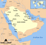
Saudi Arabia
Area 756,984 square mi (1,960,582 square km) Population 30.89 million 2014 Capital Riyadh Highest Point 10,278 ft (3,133 m) Lowest Point 0 m GDP $746.2 billion 2014 Primary Natural Resources petroleum, natural gas, iron ore, gold. LOCATED ON THE ARABIAN Peninsula in the MIDDLE EAST between the ARABIAN SEA, the RED SEA, OMAN, YEMEN, the UNITED ARAB […]
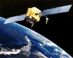
satellites
THE GLOBAL POSITIONING System (GPS) is a constellation of earth-orbiting satellites developed by the U.S. Department of Defense to provide global, all weather and 24-hour positioning capabilities to ground-based GPS receivers. Although the original system was intended for military use, it has also found important and widespread applications in civilian positioning, navigation, and mapping. Positioning is about determining an exact location based on […]
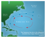
Sargasso Sea
THE SARGASSO SEA is located in the North ATLANTIC OCEAN. The area of the sea is found between 20 degrees N and 35 degrees N latitude and 30 degrees W and 75 degrees W longitude—the hump extending northward of BERMUDA. This is also known as the “horse latitudes.” The Sargasso Sea, relatively calm and motionless, is unique, as it has no […]
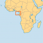
Sao Tome and Principe
Area 386 square mi (1,001 square km) Population 186,300 (2014) Capital Sao Tome Highest Point 6,640 ft (2024 m) Lowest Point 0 m GDP $337.4 million (2014) Primary Natural Resources bananas, cocoa, coconuts, coffee, fish. ONE OF AFRICA'S smallest countries, the Democratic Republic of Sao Tome and Principe consists of two main islands (Sao Tome […]
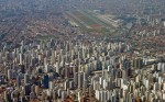
Sao Paulo
SAO PAULO IS THE largest city in BRAZIL and serves as the capital of the state of Sao Paulo. With a metropolitan area population nearing 20 million at the start of the 21st century, Sao Paulo is the biggest city in South America and one of the fastest-growing urban areas in the world. The city is the industrial center of Brazil, […]
San Marino
Area 38 square mi (61.2 square km) Population 31,600 2014 Capital San Marino Highest Point 2,492 ft (755 m) Lowest Point 182 ft (55 m) GDP $1.900 billion 2008 Primary Natural Resources building stone, wheat, grapes, corn. SAN MARINO IS one of Europe's five microstates. Like the others, it is a holdover from a more […]
Samoa
Area 1,137 square mi (2,944 square km) Population 191,800 2014 Capital Apia Highest Point Mauga Silisili 6,092 ft (1,857 m) Lowest Point 0 m GDP $800.4 million 2014 Primary Natural Resources hardwood forests, fish. THE SAMOAN ARCHIPELAGO lies approximately midway between the Hawaiian islands and NEW ZEALAND and consists of scores of islands and atolls. Human […]
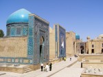
Samarqand
SAMARQAND (SAMARKAND), the second-largest city in UZBEKISTAN, is known as the mirror of the world, the garden of the soul, the jewel of ISLAM, the pearl of the East, the center of the universe, and the city of famous shadows. In the Zerafshan Valley, with high snowcapped mountains of the Pamir–Altai mountain spurs on the northeast, it is an oasis on […]
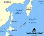
Sakhalin Island
SAKHALIN IS THE LARGEST island of the Russian Federation, 589 mi (948 km) long and 16 to 105 mi (25 to 170 km) wide, with an area of 24,560 square mi (78,000 square km). Sakhalin is separated from the mainland by the narrow and shallow Mamiya Strait or Strait of Tartary, which often freezes in winter in its narrower part, and […]
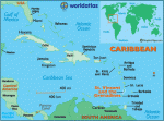
Saint Vincent and the Grenadines
Area 152 square mi (389 square km) Population 109,400 2014 Capital Kingstown Highest Point Soufriere 4,072 ft (1,234 m) Lowest Point 0 m GDP $729.3 million 2014 Primary Natural Resources hydropower, cropland. THE COUNTRY OF Saint Vincent and the Grenadines is located in the Windward Islands section of the Antilles chain, between SAINT LUCIA and GRENADA in […]
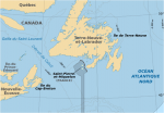
Saint-Pierre and Miquelon
AS FRENCH TERRITORIES (93 square mi or 242 square km) and a curious leftover from the chessboard games of colonial diplomacy of the 18th-century great powers, the tiny islands of Saint-Pierre and Miquelon are the only remaining fragments of the once mighty French North American empire. Consisting of two small islands, no more than barren rocks with two small settlements, the territory's […]
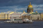
Saint Petersburg
THE CITY OF SAINT Petersburg in RUSSIA is known throughout the world as one of the marvels of urban planning and magnificent architecture. As the capital of the Russian Empire from 1712 to 1918, the city was the staging ground for the dramatic events of Russian history, from Peter the Great's forced introduction of Western (modern) customs in the early 18th […]
Saint Lucia
Area 238 square mi (616 square km) Population 183,600 2014 Capital Castries Highest Point 3,135 ft (950 m) Lowest Point 0 m GDP $1.404 billion 2014 Primary Natural Resources forests, minerals (pumice), geothermal potential. THE COUNTRY OF SAINT LUCIA is the secondlargest and the most picturesque of the Windward Islands. The island is known for its beauty […]
Saint Kitts and Nevis
Area 102 square mi (261 square km) Population 54,940 2014 Capital Basseterre Highest Point 3,815 ft (1,156 m) Lowest Point 0 m GDP $852.2 million 2014 Primary Natural Resources arable land, sugarcane, rice, yams, vegetables. THE FEDERATION OF SAINT KITTS and Nevis together form one of the newest nations in the Western Hemisphere. Formerly part of the […]
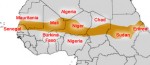
Sahel
SAHEL (OR SAHIL) MEANS “edge or border” in Arabic. The Sahel is a semiarid transitional zone between the southern edge of the SAHARA DESERT and the humid savannah zone of Africa. On average it is 187 mi (300 km) wide. It has a fragile ecology but is also diverse in plant and animal species. The Sahel stretches across North Africa from […]
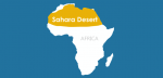
Sahara Desert
THE SAHARA IS THE world's largest desert. Covering about 3,320,000 square mi (8,600,000 square km) it is roughly the size of the UNITED STATES. It extends across the whole of North Africa from the ATLANTIC OCEAN to the RED SEA, a distance of more than 3,500 mi (5,630 km). It stretches south for at least 1,200 mi (1,930 km). The Sahara […]
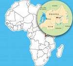
Rwanda
Area 16,365 square mi (26,338 square km) Population 11.34 million (2014) Capital Kigali Highest Point 14,826 ft (4,519 m) Lowest Point 3,100 ft (950 m) GDP $7.890 billion (2014) Primary Natural Resources gold, cassiterite (tin ore). RWANDA, LOCATED in Central Africa, is a landlocked country of savanna GRASSLAND with a population that is predominantly rural. It is […]
Ruwenzori Mountains
SHROUDED IN MISTS sitting under the hot sun of the equator is a mountain range believed to be the mysterious “Mountains of the Moon” spoken of by the ancient Greeks. Their discovery is actually credited to Henry Morton Stanley of Britain, who in 1888, while on expedition, glanced up one day and saw what the native porters at the time believed […]
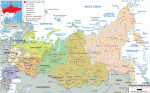
Russian Federation
Area 6.6 million square mi (17 million square km) Population 143.8 million 2014 Capital Moscow Highest Point 18,476 ft (5,633 m) Lowest Point -91 ft (-28 m) GDP $1.861 trillion 2014 Primary Natural Resources oil, natural gas, coal. STRETCHING IN A GIGANTIC arc around the ARCTIC OCEAN and North Pole, the Russian Federation spans 11 time zones, nearly half the globe from east […]
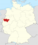
Ruhr Valley
IN TERMS OF LENGTH and volume, the Ruhr River is not one of GERMANY's major rivers. But considered as a center of economic activity, the Ruhr is among the most prominent rivers in Europe. Starting in the early 19th century, the coal that was mined in this region was processed in factories all along the river's course, creating one of the […]
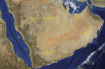
Rub’ al-Khali
THE RUB' AL-KHALI (Arabic for “Empty Quarter”) is located in the southern part of the Arabian Desert. The Al-Murrah Bedouin, who roam its southern edges call it the ar-Ramlah, the “sand.” It covers an area of about 250,000 square mi (647,500 square km). It is somewhat smaller than TEXAS or about as large as FRANCE together with BELGIUM and Holland. Most […]
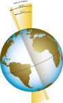
rotation, Earth axis
EARTH HAS TWO primary motions: revolution and rotation. The first refers to the earth's annual orbit of the sun, which takes a bit more than 365 days per year (hence, a leap year with 366 days every four years in order to “catch up”). As it revolves around the sun, the Earth rotates on its axis once every 24 hours, […]
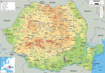
Romania
Area 91,000 square mi (237,500 square km) Population 19.91 million 2014 Capital Bucharest Highest Point 8,346 ft (2,544 m) Lowest Point 0 m GDP $199.0 billion 2014 Primary Natural Resources oil, natural gas, timber, coal, iron ore. ROMANIA IS AN OVAL-shaped country in southeastern Europe. Situated in the northeastern part of the Balkan Peninsula, it is halfway between the ATLANTIC OCEAN and the […]
Rocky Mountains
THE ROCKY MOUNTAINS are a chain of mountain ranges 3,000 mi (4,800 km) long and as wide as 350 mi (563 km) running predominantly north to south in the western part of the North American continent. The Rockies run through the U.S. states of NEW MEXICO, COLORADO, UTAH, WYOMING, IDAHO, MONTANA and ALASKA, as well as the Canadian provinces of Alberta and […]
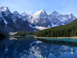
river
A RIVER IS A LARGE STREAM OF WATER flowing in a bed or channel and emptying into the ocean, a sea, a lake, or another stream. Rivers have a starting point called a source, and a mouth, where they empty into a larger body of water. Its source may be a spring, lake, or mountain snowmelt, and its ultimate destination […]
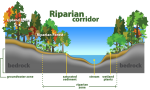
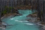
riparian
RIPARIAN IS DERIVED from the Latin riparius, meaning “of the river bank.” The term was historically used to describe the area of land lying adjacent to a body of water: primarily streams or rivers but also lakes. Riparian areas are ecotones—transition areas or interfaces between terrestrial and aquatic ECOSYSTEMs. As such, riparian areas possess features and processes influenced by adjacent ecosystems as […]
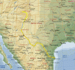
Rio Grande
THE RIO GRANDE was once known as “Rio del Norte,” and the first to describe it to Europeans was Captain General Juan de Onate, whose party of exploration first visited the river on April 20, 1598. The river was then called Corre del Norte, meaning that its current ran from the north. It is the second-largest river in North America, running […]
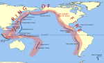
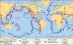
Ring of Fire
The Pacific Ring of Fire is an arc of intense EARTHQUAKE (seismic) and volcanic activity stretching from NEW ZEALAND, along the eastern edge of Asia, north across the ALEUTIAN ISLANDS of ALASKA, and south along the coast of North and South America. It is made up of over 75 percent of the world's active and dormant volcanoes. The Ring of Fire […]
rift valley
A RIFT VALLEY IS A trenchlike basin with steep parallel sides. The valley is essentially a down-faulted crustal block (grabben) between two parallel faults. A rift valley is different from an ordinary grabben for its remarkable length and depth. Such extraordinary basins typically occur where tectonic plates diverge. The release of Earth's interior energy creates most rift valleys in the processes of […]
Rhone River
THE RHONE IS THE chief river of southeastern FRANCE, draining much of the western ALPS and connecting the regions of the interior to the MEDITERRANEAN coast. From its rise in the Swiss Alps to its wide DELTA, the Camargue, the river travels 500 mi (800 km), at first through narrow and twisting mountain valleys, but from Lyon to the sea (170 […]
Rhode Island
RHODE ISLAND, SMALLEST of the 50 United States at 1,214 square mi (3,144 square km), is located in New England on the ATLANTIC seaboard. It is bounded by MASSACHUSETTS on the north and east, the Atlantic Ocean to the south, and CONNECTICUT in the west. While it is typically referred to as Rhode Island, the official name is actually the State […]
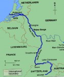
Rhine River
WITH A TOTAL LENGTH of 820 mi (1,320 km) flowing through SWITZERLAND, GERMANY, and the NETHERLANDS, the Rhine is the longest river in Germany and probably the most important waterway of western Europe. The Vorderhein, Hinterrhein, and Alpenrhein are the sources of the river within Switzerland. The Rhine then enters the Bodensee (Lake Constance) and reemerges as the Hochrhein up to Basel […]

resource
THE WORD resource is derived from the Latin resurgere, meaning to “rise again.” Therefore, a resource can be part of a cyclical process that can change and return over time and space. Resources are those elements that humans have the knowledge and technology to utilize to provide desired goods and services. Resources are subjective, functional, and dynamic. They can be tangible things […]

religion
RELIGION CAN BE DEFINED as a unified set of beliefs, values, and practices of an individual or a group of people that is based on the teachings of a spiritual leader. It includes codes of behavior, faith in and devotion toward a supernatural power or powers, and a framework for understanding the universe. Religion is an important component of many individuals' […]
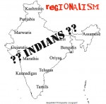
regionalism
REGIONALISM IS A COMPLEX and contested concept. As such, there is no straight or simple answer to what regionalism is. One thing for sure is that regionalism is closely related to REGION. Since a region may connote geographical contiguity ranging from a small neighborhood to a few cities right up to several states and continents, regionalism thus can exist within a state, […]
region
THE NOTION OF REGIONS has been central to geographic thinking, first because of the importance of the observation and its corollary, and second because of the classification in classic geography emphasized by the empiricism and primacy of the field survey. The term region originates from Old French and stems from the Latin regio, meaning “direction and district,” and from regere, meaning “to […]
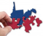
redistricting
THE PROCESS OF redistricting means dividing anew into districts or, in particular, to revise the legislative districts of a certain area, typically of a city or state. In the UNITED STATES, the process of redistricting is also referred to as “legislative reapportionment,” which the U.S. Constitution requires so that Congressional representatives are elected according to population. The process of redistricting redraws the […]
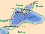
Red Sea
THE RED SEA CONNECTS the MEDITERRANEAN SEA to the INDIAN OCEAN via the Suez Canal. It lies in the Great Rift Valley between Africa and the Arabian Peninsula. EGYPT, SUDAN, ERITREA, and DJIBOUTI border it to the west, while ISRAEL is to the north and JORDAN, YEMEN, and SAUDI ARABIA are the to the east. Scientists believe it was formed 20 […]
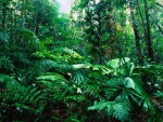
rainforests
THE WORLD'S RAINFORESTS are often considered the world's “hot spots” since they are often found in tropical climates and they are home to the majority of the world's species. As of 2000, studies and surveillance indicated that rainforests may have from one-half to two-thirds of the world's species, despite only covering 5–7 percent of the world's surface. Biodiversity is just one of […]
Quaternary geography
THE QUATERNARY PERIOD is the time in which people became fully human and the dominant animal species on earth. The Quaternary is Earth's most recent geological period and includes the Pleistocene and Holocene epochs. (Eras, periods, and epochs comprise the geological calendar. An era is the longest unit of geologic time. Traditionally, geologists identify periods as beginning and ending with the appearance […]
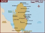
Qatar
Area 4,415 square mi (11,437 square km) Population 2.172 million 2014 Capital Doha Highest Point Qurayn Abu al Bawl 338 ft (103 m) Lowest Point 0 m GDP $210.1 billion 2014 Primary Natural Resources petroleum, natural gas, fish. QATAR IS LOCATED in the MIDDLE EAST; it is a peninsula projecting into the PERSIAN GULF and bordered […]
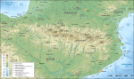
Pyrenees
THE PYRENEES MOUNTAINS form the natural border between FRANCE and SPAIN, and have been a more effective barrier between the two nations than other ranges of similar height because of their characteristic ruggedness and lack of usable passes. Even more so than the ALPS, the Pyrenees were impassable to travelers for many centuries. Today, however, […]
Puncak Jaya
PUNCAK JAYA, THE highest peak of the Sudirman Range of Papua, is also the highest mountain between the ANDES and the HIMALAYAS, rising to 16,503 ft (5030 m) on the tropical island of New Guinea. It was first named Mount Carstenz after the Dutch navigator Jan Carstenz, who first sighted the peak from the coast […]