geographic database
A GEOGRAPHIC database can be defined as a catalog that stores data that are spatially referenced. These databases are collections of similar data that are related either through location, data structure or type, or common underlying purpose. Geographic databases can be divided into two main data concepts, graphic and nongraphic. Nongraphic data is data that […]
gender geography
GENDER GEOGRAPHERS, prominent in the discipline since the 1980s, focus their research on the differences between men and women in virtually all aspects of social, economic, and political life and the resulting inequalities that result. The sub-discipline of gender geography has grown dramatically over the past two decades and there is a specialty group within […]
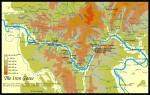
Ganges River
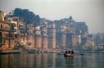
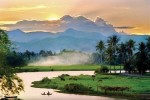
ORIGINATING IN TIBET and flowing 1,557 mi (2,507 km) from northwest to southeast through INDIA, the Ganges River empties into the BAY OF BENGAL. Known as the Ganga in India, it is the most important river in South Asia, sustaining the lives of literally hundreds of millions of people daily. Along with its sister river […]
Gambia
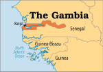
Area 4,361 square mi (11,300 square km) Population 1.909 million (2014) Capital Banjul Highest Point 174 ft (53 m) Lowest Point 0 m, GDP $807.1 million (2014) Primary Natural Resources peanuts, millet, sorghum, corn, sesame, cassava. GAMBIA IS BORDERED by the ATLANTIC OCEAN on the west and surrounded on the remaining three sides by SENEGAL. […]
gallery (galeria) forests
GALLERY FORESTS are commonly defined as any forest along a river or stream, especially in a grassland. Since geographers frequently cite BRAZIL as the best example of this phenomenon, we often use the Portuguese word galeria to identify it. Gallery forests are also found in places other than Brazil. For example, an article in the […]
Gaia
THE IDEA THAT nature is a holistic unity has been constantly existent throughout human history. The major reemergence of the idea took place in the early 20th century in the name of holism. This reappearance of holism became the foundation of the Gaia hypothesis, the most recent recurrence of the ancient belief of the harmonious […]
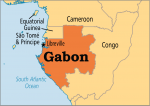
Gabon
Area 103,347 square mi (267,669 square km) Population 1.711 million (2014) Capital Libreville Highest Point 3,215 ft (980 m) Lowest Point 0 m GDP $17.23 billion (2014) Natural Resources cocoa, coffee, timber, minerals (gold). LOCATED ON THE ATLANTIC OCEAN coast in Central Africa, Gabon shares borders with CAMEROON, Republic of the CONGO, and EQUATORIAL GUINEA. […]
Fulda Gap
LOCATED IN GERMANY, between the cities of Leipzig and Frankfurt, and oriented along the Fulda River, the Fulda Gap is a name given to a mobility corridor oriented on a line that runs from Leipzig toward Frankfurt. It is bounded on the south by the Vogelsberg Hills and on the north by high ground north […]
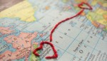
frontier
AS WITH SO MANY geographic terms, the concept of frontiers is closely linked with other ideas. In practice, frontiers rarely remain the same; changing with time and technology, and in the process adjusting the world they have affect upon. It has become common to view frontiers in reference to some political or geographical area that lies […]
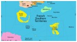
French Southern Territories
ONE OF THE MOST remote spots on Earth, the French Southern Territories consists of three groups of islands in the southern INDIAN OCEAN, not too far from the coast of ANTARCTICA, and a thin slice of the Antarctic continent itself, known as Adelie Land. No one lives permanently in these territories, but they are seasonally […]
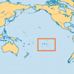
French Polynesia
FRENCH POLYNESIA IS a French overseas territory situated in the south central PACIFIC OCEAN. There are five inhabited archipelagos: the Society, Tuamotu, Gambier, Australes, and Marquesas island chains. The islands are volcanic but the Tuamotu chain is made up of low coral atolls of which there are 80. French Polynesia numbers 121 islands in all, […]
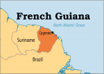
French Guiana
FRENCH GUIANA, or Guyane francaise, is the only one of the three Guianas (British, Dutch, and French) to retain its political links with Europe. Having been a full part of the French state as an overseas department since 1946—and thus a part of the EUROPEAN UNION— its citizens look to Europe more than to South […]
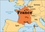
France
Area 212,796 square mi (545,630 square km) Population 66.20 million 2014 Capital Paris Highest Point 15,863 ft (4,807 m) Lowest Point -6.6 ft (-2 m) GDP $2.829 trillion 2014 Primary Natural Resources coal, iron ore, bauxite, zinc, potash, timber. ONE OF THE DOMINANT nations of Europe since the 9th century, and of the world since […]
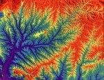
fractal geography
IN THE FRACTAL Geometry of Nature (1983), Benoit Mandelbrot writes, “Clouds are not spheres, mountains are not cones, coastlines are not circles, and bark is not smooth.” In an effort to more properly analyze and represent nature mathematically, Mandelbrot developed a new geometric pattern called a fractal. There are various definitions for the complex structure of […]
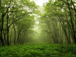
forests
FORESTS COVER approximately 27 percent of the ice-free surface of the Earth, 13 million square mi or 34 million square km. The world's forests mainly occur in two broad zones: one centered in the tropical regions, the other in the Northern Hemisphere between 32 degrees N and 45 degrees N latitude. Globally, forest composition and […]
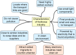
footloose industries
THE IDEA OF FOOTLOOSE industries has changed along with the transformation from an industrial to a postindustrial economy. The core concept remains the same, however: A footloose industry does not have a strong locational preference because the resources, production skills, and consumers on which it depends can be found in numerous places. Such a company […]
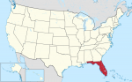
Florida
Florida“THE SUNSHINE State,” covering an area of 58,560 square mi (151,714 square km), is the most southern state of the UNITED STATES and is mainly a large lowlying peninsula, measuring from north to south about 430 mi (690 km), bounded by the ATLANTIC OCEAN on the east, the Gulf of Mexico on the west, and […]
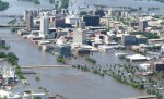
floods
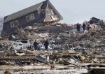
OF ALL THE NATURAL hazards in the world, floods are the most widespread. Historically, floods have killed more people and caused more damage than any other type of natural disaster. A flood is defined as an overflowing of water on an area that is normally dry. There are several types of flooding, including river flooding, […]
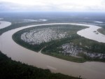
floodplain
FLOODPLAINS HAVE been a focal point of settlement throughout history and of controversy in recent decades. Humans are drawn to floodplains to cultivate the fertile soils that compose them. Floodplains are some of the best lands for growing crops, but they come with a price. Sometimes, rivers exit their banks and inundate the flat lands […]
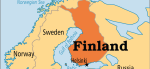
Finland
Area 130,500 square mi (338,000 square km) Population 5.464 million 2014 Capital Helsinki Highest Point 4,426 ft (1,328 m) Lowest Point 0 m GDP $270.7 billion 2014 Primary Natural Resources timber, metals arable land. AS CITIZENS OF the northernmost country in Europe, the people of Finland have long experienced the effects of their nation's absolute […]
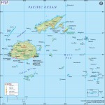
Fiji
Area 6,767 square mi (18,270 square km) Population 887,000 2014 Capital Suva Highest Point Tomanivi 4,343 ft (1,324 m) Lowest Point 0 m GDP $4.030 billion 2014 Primary Natural Resources timber, fish, gold, copper, offshore oil. THE REPUBLIC OF the Fiji Islands, a part of Oceania, is an archipelago in the South PACIFIC OCEAN, about […]
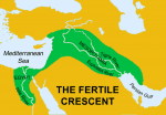
Fertile Crescent
THE FERTILE CRESCENT, an area between the Tigris and Euphrates rivers, was called Mesopotamia by the ancient Greeks. This meant “the land between the rivers.” The Fertile Crescent extends from the eastern shore of the MEDITERRANEAN SEA to the PERSIAN GULF and gets its name from its shape. James Breasted, an archeologist from the University […]

federation
GEOGRAPHICALLY, a federation (from the Latin foedus, meaning “league,” “ covenant,” or “ alliance”) is a political system created by the voluntary association of distinct political units and formally established by treaty or compact. It is a system of dual sovereignty. Each unit maintains some form of independent administrative power or local identity and sovereignty. […]

Fayum
FAYUM (also spelled “Faiyum” or “Fayyum”), comes from the Coptic Phiom (“sea”), and geographically designates a muhafazah (governorate), formerly a mudiria (province) of Upper EGYPT, an oasis in northcentral Egypt adjacent to the NILE RIVER, with significant paleontological and archaeological interest. Fayum is one of 26 administrative divisions of the Arab Republic of Egypt and […]
Faroe Islands
THE FAROE OR FAEROE Islands (Faeroerne in Danish, Faroyar in Faroese, meaning the “Sheep Islands”) are located at the intersection of the North ATLANTIC OCEAN and the Norwegian Sea, roughly equidistant between NORWAY, SCOTLAND, and ICELAND. Their closest neighbors are the Shetland Islands, 190 mi (305 km) to the southeast. Like the Shetlands, the Faroes […]
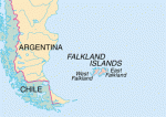
Falkland Islands
THE FALKLAND ISLANDS, a British dependency contested by ARGENTINA, which calls them the Islas Malvinas, are located in the South ATLANTIC OCEAN near South America, approximately 300 mi (483 km) east of Argentina. The Falkland Islands consist of two main islands (East and West Falklands), which are divided by the Falkland Sound. There are more […]
facilities mapping
FACILITIES MAPPING (FM) is the process of digitally identifying and mapping facilities infrastructure with the explicit goal to improve operational management and planning tasks such as dispatching, inventorying, and maintenance. Some examples of facilities include utilities (gas, water, telephone, and electricity), airport siting, and transportation planning. In the past, when a facilities map was needed, […]
exotic rivers
THERE IS A WRITTEN record on the land in the Near East. Here, civilization arose out of the mysteries of the stone age and gave rise to cultures that moved eastward to CHINA and westward through Europe and across the ATLANTIC OCEAN to the Americas. Achievements of ancient origin serve as constant reminders of our […]
Everest, Mount
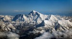
A PEAK ON THE CREST of the Great Himalayan range in Asia, Everest is the highest point on the Earth. It lies in the Central HIMALAYAS on the border between NEPAL and CHINA (Tibet). Three barren ridges, the southeast, northeast and west culminate in two summits at Everest (29,028 ft or 8,848 m) and South […]
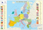
European Union
THE EUROPEAN UNION (EU), with 25 member states in 2004, had its initial organization created after World War II for the purpose of rebuilding Europe after the turmoil and devastation of the war. It was thought that economic and political cooperation would greatly reduce the risks of repeating such a conflict and would be the […]
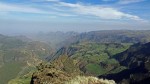
Ethiopian Highlands
ETHIOPIA IS A LANDLOCKED nation located in northeastern Africa in an area known as the HORN OF AFRICA. While containing large stretches of plains in the east and south, the country is dominated by highlands, which rise to well over 3,000 ft (1,300 m), and the Great Rift Valley, which is several hundred meters below sea […]
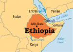
Ethiopia
Area 435,184 square mi (1,127,127 square km) Population 96.51 million (2014) Capital Addis Ababa Highest Point 15,158 ft (4,620 m) Lowest Point -410 ft (-25 m) GDP $54.80 billion (2014) Primary Natural Resources precious metals, natural gas. ETHIOPIA IS LOCATED in northeastern Africa, an area rich in geography, climate, and history. The Great Rift Valley, […]
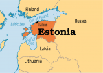
Estonia
Area 16,852 square mi (43,211 square km) Population 1.314 million 2014 Capital Tallinn Highest Point 1,050 ft (318 m) Lowest Point 0 m GDP $25.90 billion 2014 Primary Natural Resources oil shale, peat, phosphorite, clay, limestone, dolomite. FOR CENTURIES DOMINATED by its larger and stronger neighbors, since independence from the former Soviet Union in 1991, […]
esker
AN ESKER IS A LONG, narrow, often snakelike ridge of sand and gravel deposited on top of the ground where a glacier has retreated. Eskers often follow valleys and lowlands, although some can go uphill. Most eskers are a single ridge, but there are also braided ridges, which are similar in shape to river tributaries. […]
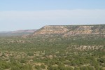
escarpment
IN GEOLOGY, an escarpment is a steep edge of a ridge or cliff, characterized by an abrupt transition in altitude between two relatively level but differently composed series of sedimentary rocks, differing in age and composition. Escarpments, also known informally as “scarps,” are usually representative of the line of erosion of newer rock over the […]
erosion
EROSION HAS MADE huge changes in the surface of the Earth and is still doing so today. Erosion is the removal of materials from the Earth's surface by a variety of processes. The material is eventually deposited elsewhere, often far from where it started. Most erosion is caused by the action of wind, water, or […]
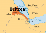
Eritrea
Area 46,662 square mi (121,320 square km) Population 6.536 million (2014) Capital Asmura Highest Point 9,959 ft (3,018 m) Lowest Point -248 ft (-75 m) GDP $3.858 billion (2014) Primary Natural Resources precious metals, natural gas. ERITREA IS LOCATED in northeastern Africa, an area known as the HORN OF AFRICA, where the RED SEA empties […]
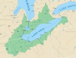
Erie, Lake
LAKE ERIE, bordered by the province of Ontario in CANADA to the north, NEW YORK to the east, PENNSYLVANIA and OHIO to the south, and MICHIGAN to the west, is the shallowest of the Great Lakes at only 62 ft (18.9 m) and it remains the smallest in volume. Lake Erie is 241 mi wide […]
erg
THE TERM erg is the Bedouin name for a very large body of sand dominated by sand dunes. Bedouins are an African tribe of nomadic herders living in the northern SAHARA DESERT. Two equivalent English-language terms are sand sea and dune field. Transverse dunes typically are part of ergs, or sand seas. As sand is […]
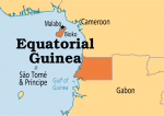
Equatorial Guinea
Area 10,831 square mi (28,051 square km) Population 778,100 (2014) Capital Malabo Highest Point 9,870 ft (3,008 m) Lowest Point 0 m GDP $14.31 billion (2014) Primary Natural Resources petroleum, wood uranium, gold, manganese. EQUATORIAL GUINEA is located in west-central Africa just north of the equator. It is made up of Rio Muni on the African […]

epidemiology
THE WORD EPIDEMIOLOGY is derived from the Greek epi (“upon”), demos (“people”), and logos (“study of”). It refers to the study of phenomena that have been put “upon” people, specifically, afflictions that weigh upon the health of a population over space and time. Epidemiology is a multidimensional science that deals with the study and occurrence […]
entrepot
AN ENTREPOT (from the Latin emporium) is a settlement founded specifically for commercial activity or a market or mart located within or on the periphery of an administrative/political center. The origins of the entrepot are traced to the commercial behavior of ancient societies. Traders entering foreign territory were exposed to numerous natural and cultural hazards. […]

energy geography
ENERGY GEOGRAPHY IS a subdiscipline of geography that draws from many philosophical and thematic traditions, but it is primarily positioned in the interface of environmental and economic concerns. The extraction, harnessing, and consumption of the natural resources that supply society with our energy needs have always been central to economic activities. Over time, however, it […]
enclave
AN ENCLAVE is a political unit that is completely enclosed within a foreign territory. It is called an “exclave” from the perspective of the country that has sovereignty over it. An enclave can also exist on a subnational level when a subdivision has land outside its parent territory. The enclaves can be created for geological, […]
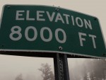
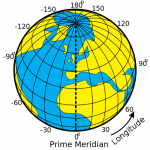
elevation
ELEVATION CAN BE defined as a measure of the height above mean sea level. When specifying a location on (or above) the surface of the Earth, elevation is commonly considered to be the third coordinate, complementing measures of LATITUDE AND LONGITUDE. Similarly, bathymetric measurements provide a depth below mean sea level to the floor of […]
electoral geography
ELECTORAL GEOGRAPHY is a part of POLITICAL GEOGRAPHY. It is the geographical study of political space in democratic states. Electoral research in dictatorships can be useful although, their citizens are not really freely choosing. Electoral geography is therefore a special study of electoral processes and districts to map election results and then to test the […]
Elburz Mountains
THE ELBURZ (or Alborz) Mountains are a narrow mountain range that curve along the southern shore of the Caspian Sea in the north of IRAN. From west to east, the range measures about 600 mi or 970 km long. The Elburz range forms a climatic barrier between the Caspian and the Central Iranian Plateau. The […]
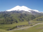
Elbrus, Mount
MOUNT ELBRUS IS the highest point in Europe, at 18,513 ft (5,642 m). It is the central peak of the CAUCASUS MOUNTAINS range, located 6.8 mi (11 km) north of the main ridge that forms the boundary between GEORGIA and RUSSIA, thus placing the mountain within Europe, since the traditional dividing line between Asia and […]
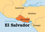
El Salvador
Area 8,108 square mi (21,000 square km) Population 6.384 million 2014 Capital San Salvador Highest Point 8,956 ft (2,730 m) Lowest Point 0 m GDP $25.22 billion 2014 Primary Natural Resources coffee, sugar, corn, rice, beans. THE REPUBLIC of El Salvador is located on the PACIFIC OCEAN in Central America, between GUATEMALA and HONDURAS. It […]
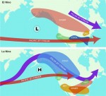
El Nino and La Nina
EL NINO AND La Nina are parts of global weather systems that recur every two to seven years. An El Nino, which usually lasts 12 to 18 months, is characterized by warm winters and wet springs in North America, a lessening of monsoonal rains in Asia, and droughts affecting Africa and the south PACIFIC OCEAN. […]
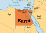
Egypt
Area 622,272 square mi (1,001,450 square km) Population 83.39 million (2014) Capital Cairo Highest Point 8,625 ft (2,629 m) Lowest Point -436 ft (-133 m) GDP $286.5 billion (2014) Primary Natural Resources cotton, rice, corn. EGYPT HAS BEEN a unified state for more than 5,000 years and is one of humanity’s oldest civilizations of great […]
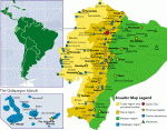
Ecuador
Area 109,483 square mi (283,560 square km) Population 15.98 million 2014 Capital Quito Highest Point 20,561 ft (6,267 m) Lowest Point 0 m GDP $100.5 billion 2014 Primary Natural Resources petroleum, fish, timber, hydropower. ECUADOR IS A SMALL country located on the west coast of South America. The equator crosses the country, thus giving Ecuador […]
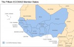
ECOWAS
THE ECONOMIC COMMUNITY of West African States (ECOWAS), also known in French as Communaute Economique des Etats de l'Afrique de l'Ouest (CEDEAO), was first formally set out at the Monrovia Group meeting in April 1968. By the Treaty of Lagos, 15 representatives from West African states formed ECOWAS in Lagos, NIGERIA, on May 28, 1975. […]
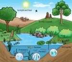
ecosystem
THE CONCEPT OF the ecosystem began with the establishment of the science of ecology which is credited to Ernst Haekel, a German zoologist who coined the term ecology in 1869. He based this term on the Greek word oikos, meaning “a place in which to live.” It was another 60 years before the term ecosystem […]
economic geography
KNOWLEDGE OF ECONOMIC geography was first essentially descriptive, with a focus on the REGION and its economy, demography, and social characteristics. It represented the typical approach in research agenda in North America and Western Europe. The birth of economic geography dates from the age of European exploration, with an expansion in commercial geography from the […]
ecology
ECOLOGY IS THE study of the interaction between an organism and its physical environment. Human ecology specifically focuses on humans as a group of organisms and their mutual relationships within the habitat. The term ecology has its origin in two ancient Greek words: oikos (house or habitat) and logia (words or teaching). Thus, the concept […]
ecological niches
IN CONTEMPORARY ecology, the term ecological niches is referred to as the position occupied by representatives of any life form (usually alive) in biocenosis, and, at the same time, the smallest unit of a habitat that is occupied by an organism. The notion reflects an organism's or species's place in the community, taking into account […]
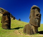
Easter Island
POLITICALLY, EASTER ISLAND has belonged to CHILE since 1888, though it lies some 2,200 mi (3,500 km) west of the coast of Chile and just south of the TROPIC OF CAPRICORN in the PACIFIC OCEAN. Its nearest neighbor is PITCAIRN ISLAND 1,132 mi (1,819 km) to the west. The major settlement is Hanga Roa. Easter […]
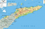
East Timor
Area 5,853 square mi (15,007 square km) Population 1.212 million 2014 Capital Dili Highest Point 9,778 ft (2,963 m) Lowest Point 0 m GDP $1.552 billion 2014 Primary Natural Resources gold, petroleum, natural gas, manganese, marble. THE ISLAND OF Timor, in the Indonesian archipelagos, is no stranger to struggle. Disputed between the Dutch and Portuguese […]
earthquakes
STRONG GROUND motion occurs whenever energy, conserved as strain in the Earth's crust or upper mantle, is released instantaneously. In such an event, commonly called an earthquake, energy radiates from the source of release in a series of waves. As waves propagate through rock and other elastic media, they cause periodic displacements (movements up and […]
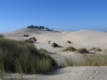
dunes
DUNES ARE PILES of windblown sediment. Geomorphologists refer to dunes and other wind-created features as aeolian landforms. (Aeolus was the ancient Greek god of the winds.) Geomorphologists also refer to dunes as sand dunes, as sand is the most common type of sediment in the deposits. Dunes sometimes include sand-size aggregates of clay, gypsum, or […]
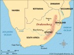
Drakensberg Mountains
THE DRAKENSBERG Mountains form one of the most scenic natural areas in SOUTH AFRICA. The mountain range straddles the eastern border of LESOTHO, a LANDLOCKED nation lying within the boundaries of South Africa, located about 150 mi (250 km) northwest of Durban. The name Drakensberg means “Dragon Mountains” in Afrikaans. The range is also known […]
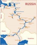
Don River
THE DON RIVER IS one of RUSSIA's major commercial rivers, which, connected to the VOLGA through the 65-mi (105-km) Volga-Don Canal, allows river traffic to sail from Russia's interior ports as far inland as MOSCOW to ports on the BLACK SEA and beyond to the MEDITERRANEAN. The Don River basin also includes its most important […]
domino theory
THE DOMINO THEORY states that if one vital country in a region falls to an expansionist negative philosophy, then other countries in the region similarly situated and similarly structured would fall victim to the same philosophy, either through force or through influence of example. In its pure form, the negative philosophy is communism but in […]
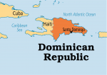
Dominican Republic
Area 20,729 square mi (48,730 square km) Population 10.53 million 2014 Capital Santo Domingo Highest Point 10,416 ft (3,175 m) Lowest Point 151 ft (46 m) GDP $63.97 billion 2014 Primary Natural Resources nickel, gold, silver. THE DOMINICAN REPUBLIC, which sits on the western portion of the island of Hispaniola in the CARIBBEAN SEA, was […]
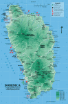
Dominica
Area 294 square mi (754 square km) Population 72,340 2014 Capital Roseau Highest Point Morne Diablatins 4,775 ft (1,447 m) Lowest Point 0 m GDP $537.8 million 2014 Primary Natural Resources timber, hydropower. THE LAST OF THE islands of the West Indies to be colonized, chiefly because of the fierce resistance of the native Carib […]
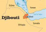
Djibouti
Area 8,958 square mi (23,000 square km) Population 886,300 (2014) Capital Djibouti Highest Point Musa Ali 6,653 ft (2,028 m) Lowest Point -550 ft (-168 m) GDP $1.582 billion (2014) Primary Natural Resources negligible. BORDERED BY ETHIOPIA, ERITREA, and SOMALIA in Africa, the country of Djibouti (the former French Somaliland and then AFARS and Issas) […]
distance
EMPLOYING THE GEOGRAPHIC sense of the term, distance can be defined as the amount of separation between two points or objects on the surface of the Earth. Geographic distance is usually expressed as a linear measurement between locations using one of several commonly accepted metrics (a metric is a standard of measurement using associated units). […]
direction
DIRECTION IS DEFINED as the line or course on which something is moving, or at which it is aimed to move, or toward which something is pointing or facing. Direction is commonly referenced as an angle made by a given line with an axis of reference, that is up, down, right, left, and so on. […]
diffusion
DIFFUSION IS the spread of a phenomenon, such as an idea, a technological innovation, or a disease, over space and time. The origins of interest in diffusion in geography can be traced back to the work of the German geographer Frederick Ratzel (1844–1904). In the second volume of his highly influential Anthropogeographie, Ratzel described the […]
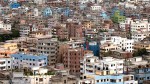
Dhaka
DHAKA BECAME the capital of the newly formed sovereign state of BANGLADESH in 1971. The city has a tropical monsoon climate with heavy summer rainfall (June through September), about 80 in (203 cm) annually. Summer is hot and humid and winter is dry and mild. It is located on a tributary of the Meghna-GANGES river […]

determinism
DETERMINISM (from the Latin determino, meaning “define”) is a basic philosophical theory about general interdependence and interconditionality of phenomena and processes. This idea was explained for the first time in ancient natural philosophy (atomistic ideas, peripathetic school), in notions about primary origins and elements. Later, it was developed by Persian poet Omar Khayyam, Italian naturalist […]
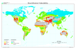
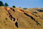
desertification
SINCE THE mid-1970s, the United Nations (UN) has considered desertification a significant environmental problem involving high economic, societal, and human costs. The UN's Conference on Desertification, held in 1977, outlined an action plan over a 20-year period that, unfortunately, did little to change the course of desertification. The definition of desertification itself is controversial. In […]
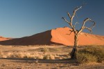
desert
THERE IS A TENDENCY, in popular opinion and some public policy, to view deserts dismissively as unproductive wastelands. The 14th edition of the Encyclopedia Britannica made the case with exuberant eloquence: “Desert, a term popularly applied to any environmentally extreme, deserted, desolate, uninhabitable waste area.” While they are indeed less productive of biomass than other […]
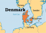
Denmark
Area 16,807 square mi (43,094 square km) Population 5.640 million 2014 Capital Copenhagen Highest Point 571 ft (173 m) Lowest Point -23 ft (-7 m) GDP $342.0 billion 2014 Primary Natural Resources petroleum, natural gas, fish, salt. DENMARK IS A COUNTRY whose history and culture is almost entirely shaped by the sea. With a coastline […]

demographics
DEMOGRAPHY IS THE study of populations (a term used to denote the collection of persons alive at a particular point in time and who meet certain criteria). Demographics have to do with population statistics. Usually referred to as a census, most often these data are collected through a survey process and by public agencies at […]
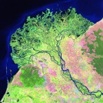
delta
A DELTA IS AN AREA of land that has been built up at the mouth of a river, where it flows into a quiet body of water, such as a lake or an ocean. The delta is formed when the river, which is moving swiftly and carrying sediment such as mud, slows down to enter […]
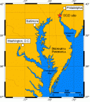
Delmarva Peninsula
THE 5,940-square-mi (15,384 square km) Delmarva Peninsula is located in the mid-Atlantic area of the UNITED STATES and borders the Chesapeake Bay, the Delaware Bay and the ATLANTIC OCEAN. The historic importance of the area is that it formed an important political and social demarcation between the North and the South of the United States: […]
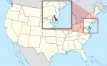
Delaware
DELAWARE IS ONE OF the Middle Atlantic states of the UNITED STATES. It is also the country's second smallest state after RHODE ISLAND, covering 2,057 square mi (5,328 square km) within the DELMARVA PENINSULA. It is bordered by MARYLAND on the west and south, NEW JERSEY to the northeast across the Delaware Bay and Delaware […]
Deccan Plateau
LOCATED IN INDIA, in the southern part of the peninsula south of the Indo-Gangetic Plain, the Deccan Plateau can be considered the cultural and historical heart of India, defining the subcontinent. The great epic poems of the Vedas tell of the coming of the Aryan-speaking peoples that dominate all of northern Indian today. However, the […]
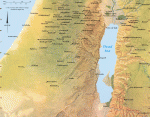
Dead Sea
THE DEAD SEA IS a 390-square-mi (1,010-squarekm) salt lake located on the borders of PALESTINE, ISRAEL, and JORDAN. It is the lowest water point in the world, and its coast, at 1,292 ft below sea level (-395 m), is the lowest dry point on Earth. The lake is divided into two unequal parts by el-Lisan […]
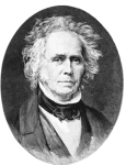
Davis, William M. (1850–1934)
WILLIAM DAVIS WAS among the leading geographers of the early part of the 20th century. Today, Davis might be more narrowly considered a geomorphologist based on his major research interests. But in his time, Davis enjoyed considerable influence over the direction and conduct of geographical science, in the UNITED STATES and in Europe. Born to […]
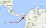
Darien Gap
STRADDLING THE BORDER of the republics of PANAMA and COLOMBIA, the Darien Gap is home to one of the least exploited and most diverse ecosystems in the world. Flanked by the PACIFIC OCEAN to the north and west and the CARIBBEAN SEA to the east, the area includes two national parks, Darien National Park in Panama […]
Danubian Gates
FOR CENTURIES, traffic along the DANUBE RIVER was hindered by a stretch of treacherous rocks and narrow gorges at the point at which the river cut through the Southern Carpathian mountain range. This stretch, about 62 mi (100 km) in length, along the border of ROMANIA and Yugoslavia (SERBIA), is known as the Danubian or […]
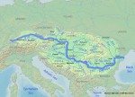
Danube River
THE DANUBE RIVER IS the longest river in western Europe, surpassed in Europe as a whole only by the VOLGA in RUSSIA. Fourteen countries are drained by its watershed, covering over 312,000 square mi (800,000 square km): GERMANY, AUSTRIA (and small parts of eastern SWITZERLAND), the CZECH REPUBLIC, SLOVAKIA, HUNGARY (and a small corner of […]
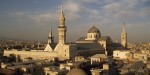
Damascus
DAMASCUS (in Arabic, “Dimashq”) is the capital and chief city of SYRIA, with a population of 1.7 million people (2002). The ancient city is also known in Arabic as “as-Sham” meaning “the Northern,” indicating its geographical position north of the traditional Arab homelands. Damascus is situated in the Ghutah Oasis on a plateau 2,263 ft […]
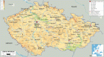
Czech Republic
Area 30,450 square mi (78,866 square km) Population 10.51 million 2014 Capital Prague Highest Point 5,256 ft (1,602 m) Lowest Point 377 ft (115 m) GDP $205.5 billion 2014 Primary Natural Resources graphite, coal, timber. THE CZECH REPUBLIC consists of the two historic regions of Bohemia and Moravia. The Czech Republic borders SLOVAKIA to the […]
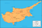
Cyprus
Area 3,604 square mi (9,250 square km) Population 1.153 million 2014 Capital Nicosia Highest Point 6,407 ft (1,951 m) Lowest Point 0 m GDP $23.23 billion 2014 Primary Natural Resources copper, pyrites, asbestos. CYPRUS IS AN island in the eastern MEDITERRANEAN SEA, 70 mi (113 km) south of TURKEY. For thousands of years, its civilization […]
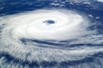
cyclones
CYCLONES ARE HAZARDOUS weather conditions distinguished by extreme blasts of wind moving in a circular pattern. Cyclones generally appear over tropical waters; however, some are able to reach land, where they inflict significant damage on buildings and communities. Cyclones can be placed into categories such as hurricane (Western Hemisphere) and typhoon (Eastern Hemisphere). The categorization […]
cultural geography
CULTURAL GEOGRAPHY IS a subdiscipline of HUMAN GEOGRAPHY. The founding father of cultural geography in North America is Carl Ortwin SAUER, and most of the research in cultural geography from the 1920s to the beginning of the 1980s was carried out by cultural geographers walking in the footsteps of Sauer and the so-called Berkeley School. […]
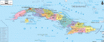
Cuba
Area 68,885 square mi (110,860 square km) Population 11.26 million 2014 Capital Havana Highest Point 6,578 ft (2,005 m) Lowest Point 0 m GDP $77.15 billion 2013 Primary Natural Resources sugar, tobacco, citrus, coffee, rice. CUBA, THE 15th largest island in world, is part of the West Indies in the CARIBBEAN SEA. This island, which […]
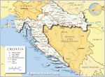
Croatia
Area 22,000 square mi (56,542 square km) Population 4.236 million 2014 Capital Zagreb Highest Point Dinara 604 ft (1,830 m) Lowest Point 0 m GDP $57.22 billion 2014 Primary Natural Resources oil, coal, bauxite, hydropower. CROATIA IS AT once one of the oldest and newest states in Europe. There has been a Croatian state of […]
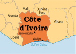
Cote d’Ivoire
Area 124,501 square mi (322,460 square km) Population 20.80 million (2014) Capital Yamoussoukro Highest Point 5,748 ft (1,752 m) Lowest Point 0 m GDP $34.25 billion (2014) Primary Natural Resources petroleum, natural gas, diamonds, manganese. COTE D'IVOIRE (Ivory Coast) is bordered by MALI and BURKINA FASO on the north, by LIBERIA and GUINEA on the […]
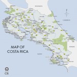
Costa Rica
Area 19,729 square mi (51,100 square km) Population 4.938 million 2014 Capital San Jose Highest Point 12,500 ft (3,810 m) Lowest Point 0 m GDP $49.55 billion 2014 Primary Natural Resources coffee, bananas, agricultural products. THE REPUBLIC OF Costa Rica, home to almost 3.9 million people, is located in Central America between NICARAGUa and PANAMA […]
core and periphery
CORE AND PERIPHERY are terms used in geographic models to describe areas of differing economic production and political power and can be applied to both intra- and interstate variations. Core areas are described as the engines of economic growth and are characterized by modern, technologically advanced production methods as well as highly skilled and highwage […]
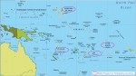
Cook Islands
PART OF NEW ZEALAND, the Cook Islands consist of 15 islands in the south PACIFIC OCEAN, about halfway between HAWAII and NEW ZEALAND. They are about the same size as RHODE ISLAND. The islands are scattered over an area of more than 706,566 square mi (1.83 million square km). The nine islands in the southern […]
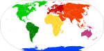
continents
THE EARTH IS AN ocean-dominated planet. Only one-third of the planet's surface is dry land. The Earth's land areas include innumerable islands and several larger expanses of land termed continents. A continent is defined as a mass of land significantly larger than an island, completely or nearly surrounded by ocean water. By common agreement among […]
continentality
CONTINENTALITY IS A climatic effect that results from a continental interior being insulated from oceanic influences. Winds and air masses of moderate temperature that originate over oceans move onshore to diminish differences in winter and summer temperatures in coastal areas of continents. Interiors of continents are too distant to experience the moderating effect. As a […]
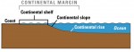
continental shelf
A CONTINENTAL SHELF is the submerged top of the continent's edge, lying between the shoreline and the continental slope that forms a border to a continent. In other words, the surface of the Earth lies at two general levels: a lower, which is the floor of the ocean basins, and an upper, the parts of […]
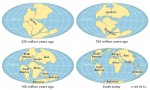
continental drift
CONTINENTAL DRIFT INVOLVES large-scale horizontal movements of continents relative to one another and to the ocean basins during one or more episodes of geologic time. The hypothesis of large-scale movement or displacement of continents has a long history. About 1800, Alexander von Humboldt, a German naturalist, noted the apparent fit of the bulge of eastern South […]