Latin America: Landforms and Resources
A HUMAN PERSPECTIVE Simon Bolivar was a general who led the South American wars of independence against Spain. In August 1819, Bolivar led approximately 2,500 soldiers on a daring march from Venezuela over the mountains into present-day Colombia. Coming from this direction, over the massive barrier of the Andes Mountains, Bolivar and his troops were able to advance unseen. Bolivar's soldiers surprised the Spanish army and won a great victory. Military leaders such as Bolivar were able to use the geography of the region to help the South American republics win their independence from Spain.
Mountains and Highlands
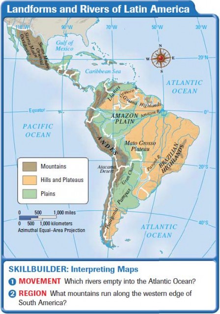
Latin America has an enormous span from north to south, as you can see from the map on page 191. It reaches from the border between the United States and Mexico down to Tierra del Fuego at the southernmost tip of South America, a distance of about 7,000 miles. It covers part of North America, all of Central and South America, and the Caribbean Islands. Its highlands, lowlands, rain forests, and plains are bounded by the Atlantic and Pacific oceans, the Gulf of Mexico, and the Caribbean Sea. The mountains of Latin America form one of the great ranges of the world.
THE ANDES MOUNTAINS
The Andes Mountains of the South American continent are part of a chain of mountain ranges that run through the western portion of North, Central, and South America. This range is called the Rockies in the United States, the Sierra Madre in Mexico, and the Andes in South America. There are many active volcanoes throughout the region.
All along the west and south coasts of South America, the Andes Mountains are a barrier to movement into the interior. As a result, more settlement in South America has occurred along the eastern and northern coasts. Even so, the mountain ranges of Latin America were the home of some of the most important civilizations in the hemisphere, including the Inca in Peru.
HIGHLANDS
Other ranges in Latin America include the Guiana Highlands in the northeast section of South America. Highlands are made up of the mountainous or hilly sections of a country. The highlands of Latin America include parts of Venezuela, Guyana, Suriname, French Guiana, and Brazil. The Brazilian Highlands are located along the east coast of Brazil.
Plains for Grain and Livestock
South America has wide plains that offer rich soil for growing crops and grasses for grazing livestock.
LLANOS OF COLOMBIA AND VENEZUELA
Colombia and Venezuela contain vast plains called llanos, which are grassy, treeless areas used for livestock grazing and farming. They are similar to the Great Plains in the United States and the pampas of Argentina.
PLAINS OF AMAZON RIVER BASIN
Brazil also contains expansive plains in the interior of the country. These are the cerrado, savannas with flat terrain and moderate rainfall that make them suitable for farming. Much of this land is undeveloped. However, the government of Brazil is encouraging settlers to move into the interior and develop the land.
PAMPAS OF ARGENTINA AND URUGUAY
In parts of South America, the plains are known as pampas), areas of grasslands and rich soil. Pampas are found in northern Argentina and Uruguay. The main products of the pampas are cattle and wheat grain. A culture of the gaucho has grown up in the region, centered on the horsemen of the pampas.
The Amazon and Other Rivers
The countries of Central America and the Caribbean do not have the extensive river systems that are found in South America. In North America, the Rio Grande, which forms part of the border between the United States and Mexico, is longer than any other river in Mexico, Central America, or the Caribbean. However, these areas are all bordered by water. As a result, they are less dependent on river systems for transportation than is South America.
South America has three major river systems. The Orinoco is the northernmost river system, with the Amazon also in the north, and the Parana in the south of the continent.
ORINOCO RIVER
The Orinoco River winds through the northern part of the continent, mainly in Venezuela. It flows more than 1,500 miles, partly along the Colombia-Venezuela border, to the Atlantic. The Orinoco River basin drains the interior lands of both Venezuela and Colombia. Some of the areas drained by the Orinoco are home to the few remaining Native American peoples, such as the Yanomamo.
AMAZON RIVER
Farther south, the Amazon River flows about 4,000 miles from west to east, emptying into the Atlantic Ocean. Its branches start in the Andes Mountains of South America, close to the Pacific. Yet it flows eastward across the central lowlands toward the Atlantic. The Amazon River is fed by over 1,000 tributaries, some of which are large rivers in themselves.
The Amazon carries more water to the ocean than any other river in the world. In fact, it carries more water to the ocean than the next seven largest rivers of the world combined.
PARANA RIVER
The Parana River has its origins in the highlands of southern Brazil. It travels about 3,000 miles south and west through Paraguay and Argentina, where it is fed by several rivers, and then turns eastward. The last stretch of the river, where it turns into an estuary of the Parana and Uruguay rivers between Argentina and Uruguay, is called the Rio de la Plata. An estuary is the wide lower course of a river where its current is met by the tides.
Major Islands of the Caribbean
The Caribbean Islands consist of three major groups: the Bahamas, the Greater Antilles, and the Lesser Antilles. These islands together are sometimes called the West Indies and were the first land encountered by Christopher Columbus when he sailed to the Western Hemisphere in 1492. They served as a base of operations for the later conquest of the mainland by the Spanish.
The Bahamas are made up of hundreds of islands off the southern tip of Florida and north of Cuba. They extend southeast into the Atlantic Ocean. Nassau is the capital and largest city in the Bahamas.
THE GREATER ANTILLES
The Greater Antilles are made up of the larger islands in the Caribbean. These include Cuba, Jamaica, Hispaniola, and Puerto Rico. The island of Hispaniola is divided between the countries of Haiti and the Dominican Republic.
THE LESSER ANTILLES
The Lesser Antilles are the smaller islands in the region southeast of Puerto Rico. The Lesser Antilles are divided into the Windward Islands and Leeward Islands. The Windward Islands face winds that blow across them. The Leeward Islands enjoy a more sheltered position from the prevailing northeasterly winds.
Resources of Latin America
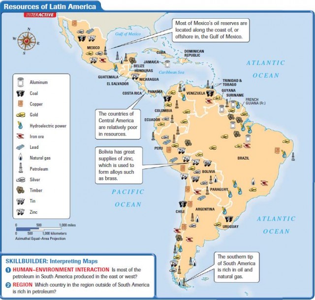
Latin America is a treasure house of natural resources. These include mineral resources, such as gold and silver, as well as energy resources, such as oil and natural gas. In addition, the region is rich in agricultural and forest resources, such as timber. These resources have drawn people to the region for centuries.
MINERAL RESOURCES
Gold, silver, iron, copper, bauxite (aluminum ore), tin, lead, and nickel—all these minerals are abundant in Latin America. In addition, mines throughout the region produce precious gems, titanium, and tungsten. In fact, South America is among the world's leaders in the mining of raw materials.
Many of these minerals are mined and then exported to other parts of the world, where they are made into valuable goods. For example, Jamaica was originally a plantation economy that depended on the sale of bananas and sugar for its livelihood. Then it turned to the mining and processing of bauxite (aluminum ore) in an attempt to make the country less dependent on agriculture and tourism. Today, this resource is mainly an export that is shipped elsewhere for industrial use.
ENERGY RESOURCES
Oil, coal, natural gas, uranium, and hydroelectric power are all plentiful in Latin America. Venezuela and Mexico have major oil reserves. Brazil is rich in hydroelectric power because of its many rivers (including the mighty Amazon) and waterfalls. It is also rich in oil and gas.
Trinidad has discovered vast reserves of natural gas. New factories have turned Trinidad into a major exporter of methanol and ammonia. Natural gas has also attracted developers to the island.
In Mexico and Venezuela, oil has been a very important resource. Venezuela sits on top of major oil deposits. This resource was developed into a significant oil industry. Mexico has huge oilfields centered along the Gulf coast. Because of its reserves, Mexico is able to export oil to other countries. However, changes in the global price of oil have had a great impact on the economies of these countries.
Latin America has great variety in its climate and vegetation. You will read about each in the next section.
- Latin America: The Income Gap
- Latin America: Giving Citizens a Voice
- Latin America: Rain Forest Resources
- Latin America: Brazil
- Spanish-Speaking South America
- Latin America: Central America and the Caribbean
- Latin America: Mexico
- Latin America: Human–Environment Interaction
- Latin America: Climate and Vegetation