Global Wind and Pressure Patterns
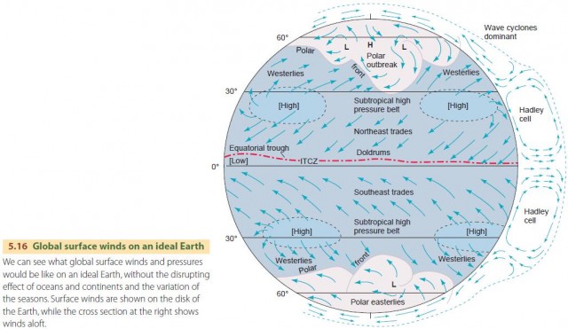
For simplicity, let's begin by looking at surface winds and pressure patterns on an ideal Earth that does not have oceans and continents, or seasons (Figure 5.16). Hadley cells are key to an understanding of the wind patterns on our ideal Earth. These form because the Equator is heated more strongly by the Sun than other places, creating thermal circulations. Air rises over the Equator and is drawn poleward by the pressure gradient. But as the air moves poleward, the Coriolis force turns it westward, so it eventually descends at about a 30° latitude, completing the thermal circulation loop. This is a Hadley cell.
The rising air at the equator produces a zone of surface low pressure known as the equatorial trough. Air in both hemispheres moves toward this equatorial trough. There it converges and rises as part of the Hadley circulation. The narrow zone where the air converges is called the intertropical convergence zone (ITCZ). Because the air is largely moving upward, surface winds are light and variable. This region is known as the doldrums. Air descends on the poleward side of the Hadley cell circulation, so there surface pressures are high. This produces two subtropical high-pressure belts, each centered at about 30° latitude. Two, three, or four very large and stable anticyclones form within these belts. At the centers of these anticyclones, air descends and winds are weak. The air is calm as much as onequarter of the time.

Winds around the subtropical high-pressure centers spiral outward and move toward equatorial as well as middle latitudes. The winds moving equatorward are the dependable trade winds that drove the sailing ships of merchant traders. North of the Equator, they blow from the northeast and are called the northeast trade winds. South of the equator, they blow from the southeast and are the southeast trades. Poleward of the subtropical highs, air spirals outward, producing southwesterly winds in the northern hemisphere and northwesterly winds in the southern hemisphere.
Between about 30° and 60° latitude, the pressure and wind patterns become more complex. This is a zone of conflict between air bodies with different characteristics—masses of cool, dry air—polar outbreaks— move into the region, heading eastward and equatorward along a border known as the polar front. This results in highly variable pressures and winds. On average, however, winds are more often from the west, so the region is said to have prevailing westerlies. At the poles, the air is intensely cold and high pressure occurs. At the South Pole, outspiraling of winds around this polar anticyclone creates surface winds from a generally easterly direction, known specifically as polar easterlies. In the north polar region, polar easterlies are weaker and other wind directions are common.
SUBTROPICAL HIGH-PRESSURE BELTS
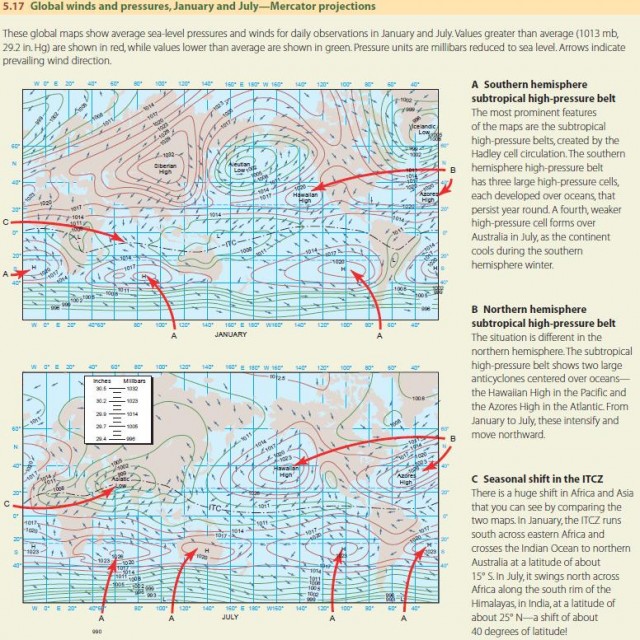
So far we've looked at wind and pressure patterns for a seasonless, featureless Earth. Let's turn now to actual global surface wind and pressure patterns, shown in Figure 5.17.
The subtropical high-pressure belts, created by the Hadley cell circulation, are important features. In the northern hemisphere, they include two large high-pressure cells that flank North America—the Hawaiian and Azores highs. In the southern hemisphere, similar high-pressure cells flank South America and southern Africa.

We've seen that insolation is most intense when the Sun is directly overhead, and the latitude at which the Sun is directly overhead changes with the seasons. This cycle causes the Hadley cells to intensify and move poleward during their high-sun season, which also moves the subtropical high-pressure belts.
When the Hawaiian and Azores highs intensify and move northward in the summer, the east and west coasts of North America feel their effects. On the west coast, dry, descending air from the Hawaiian high dominates, so fair weather and rainless conditions prevail. On the east coast, air from the Azores high flows across the continent from the southeast.
These winds travel long distances across warm, tropical ocean surfaces before reaching land, picking up moisture and heat. So they generally produce hot, humid weather for the central and eastern United States. In winter, these two anticyclones weaken and move to the south—leaving North America's weather at the mercy of colder winds and air masses from the north and west.
ITCZ AND THE MONSOON CIRCULATION
The ITCZ also shifts along with the Hadley cell circulation. The shift in the ITCZ is moderate in the western hemisphere, with the ITCZ moving a few degrees north from January to July over the oceans (Figure 5.17). In South America, the ITCZ lies across the Amazon in January and swings northward by about 20°.
However, there is a huge shift of the ITCZ in Asia— about 40° of latitude—that is readily visible on the two Mercator maps of Figure 5.17C. Why does such a large shift occur? In winter (January map), the snow cover and low insolation in eastern Siberia create an intense and very cold surface high-pressure center—the Siberian high. In summer (July map), this high-pressure center has disappeared and is replaced by a surface low centered over the Middle Eastern region. This Asiatic low is produced by the intense summer heating of the desert landscape.
The movement of the ITCZ and the change in these surface pressure patterns with the seasons create a reversing wind pattern in Asia known as the monsoon. In the winter, there is a strong outflow of dry, continental air from the north across China, Southeast Asia, India, and the Middle East. During this winter monsoon, dry conditions prevail. In the summer monsoon, warm, humid air from the Indian Ocean and the southwestern Pacific moves northward and northwestward into Asia. The cool, dry winter weather is replaced with steamy summer showers.
North America also experiences a monsoon effect, but it is considerably weaker. During summer, warm, moist air from the Gulf of Mexico tends to move northward across the central and eastern United States. In winter, the airflow across North America generally reverses, and dry, continental air from Canada moves south and eastward.
WIND AND PRESSURE FEATURES OF HIGHER LATITUDES
The northern hemisphere has two large continental masses separated by oceans and an ocean at the pole. The southern hemisphere has a large ocean with a cold, ice-covered continent at the center. These differing land– water patterns strongly influence the development of highand low-pressure centers with the seasons.
Now, continents are colder in winter and warmer in summer than oceans at the same latitude. We know that cold air is associated with surface high pressure and warm air with surface low pressure. So, continents have high pressure in winter and lower pressure in summer. In January in the northern hemisphere, we see a pattern of strong high pressure (Siberian and Canadian highs) over continents and strong low pressure (Icelandic low and Aleutian low) over northern oceans that is driven by winter temperature contrasts. In July, this pattern nearly disappears as continents and northern oceans warm to similar temperatures.
In the southern hemisphere, there is a permanent anticyclone—the South Polar high—centered over Antarctica that varies little from January to July. It occurs because the continent is covered by thousands of meters of ice and is always cold. Surrounding the high is a band of deep low pressure, with strong, inward-spiraling westerly winds on its northern side. As early mariners sailed southward, they encountered this band, where wind strength intensifies toward the pole. Because of the strong prevailing westerlies, they named these southern latitudes the “roaring forties,” “flying fifties,” and “screaming sixties.”