How Are Variations in Insolation Expressed Between the North and South Poles?
VARIATIONS IN INSOLATION, both as a function of latitude and from season to season, help explain many aspects of our world — average temperatures, hours of daylight, type of climate and weather, the type of landscape, and the overall livability of a place. For a transect down the west coasts of the Americas, from the Arctic to the Antarctic, we examine the average monthly amounts of insolation, length of day, and temperature, as a way to connect concepts in this chapter with actual places. Examine the photographs, graphs, and text for each place, and think about what explains the patterns for that place and the variations from one place to the next.
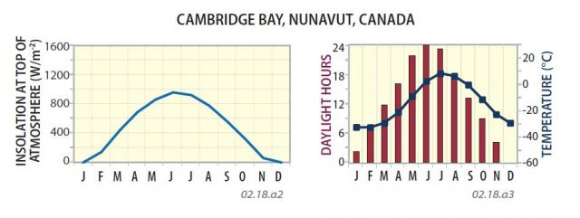
Northern Alaska and Canada
The North Pole is located in the Arctic Ocean, but parts of Alaska and Canada are north of the Arctic Circle (66.5° N). Compare the graphs to the right, which show the monthly variation in insolation (first graph), number of daylight hours (bar graph) and average temperatures (line graph). Note that during parts of winter there is no daylight.
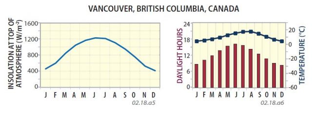
Pacific Northwest
The northwestern part of the mainland U.S. and adjacent parts of British Columbia, Canada, straddle the famous 49th parallel (49° N latitude). They are squarely in the mid-latitudes. Like most of the places on this page, the region is near the ocean, so its temperature variations are moderated somewhat by the waters of the adjacent ocean.
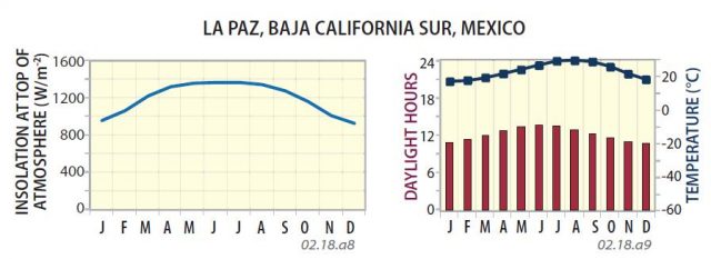
Baja California
Baja California, part of Mexico, is a desert peninsula bordered by the Pacific Ocean to the west and the Gulf of California to the east. La Paz, the capital of Baja California Sur, is at a latitude of 24° N, just north of the Tropic of Cancer (23.5° N). Note that the graphs for Baja and the two previous places display a maximum centered on June to August (summer).
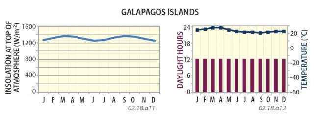
Ecuador
The South American country of Ecuador is named for its position on the equator. It is on the west coast of the continent and contains parts of the Andes, Amazon rain forest, and the Gal?pagos Islands, famous for their active volcanoes and unusual animals. Note the pattern on the length-of-day bar graph and the minor variation in monthly insolation for the equator.
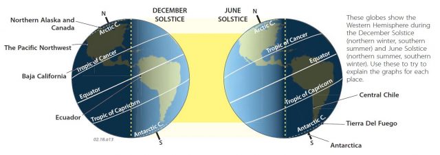
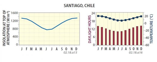
Central Chile
About halfway down the western coast of South America is the central part of Chile. The country's capital of Santiago is at a latitude of 33.5° S, south of the Tropic of Capricorn. It is inland and higher than the coast. Note that in the Southern Hemisphere, the graphs of insolation, hours of daylight, and temperatures now have central troughs rather than peaks.
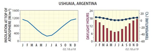
Tierra Del Fuego
Tierra del Fuego is the southernmost tip of South America, in southern Chile and Argentina. Ushuaia, Argentina, at a latitude of 54.8° S, is called the southernmost city in the world. It is not within the Antarctic Circle, so every day has some daylight and darkness. The southern tip of South America, surrounded by cold seas, is a frigid, stormy place.
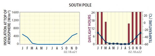
Antarctica
Antarctica, centered over the South Pole, consists of vast plains of ice with some impressive mountain ranges. The main part of the continent is within the Antarctic Circle, so it has months of darkness. The South Pole has continuous darkness from April to September (the southern winter), but 24 hours of sunlight from October to February. It is always a very cold place.