How Do the Coriolis Effect and Friction Influence Atmospheric Circulation?
THE CORIOLIS EFFECT AND FRICTION affect the patterns of air movement set in motion by pressure gradients. These phenomena influence wind direction from local scales, affecting the rotation and wind patterns of individual storms, to global scales, affecting wind patterns of the entire planet. How do pressure gradients, the Coriolis effect, and friction explain wind patterns at such diverse scales? These two pages provide an overview of global and regional patterns of air circulation, with more in-depth coverage to follow in subsequent sections.
What Influences the Patterns of Airflow Around High- and Low-Pressure Areas?
Once the pressure-gradient force starts air moving, the air is affected by the Coriolis effect and, if close to Earth’s surface, is acted on by friction with the surface. The results of these interactions produce distinctive and familiar patterns of wind and circulation of air around areas of high and low pressure.
Low- and High-Pressure Areas
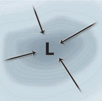
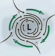
1. In an area of low pressure, the pressure-gradient force pushes air laterally into the low from all directions. If the Earth were not rotating and therefore had no Coriolis effect, this simple inward flow pattern would remain intact. Friction would likewise not perturb this pattern because friction does not change the direction of airflow, only the speed.
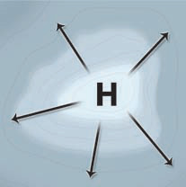
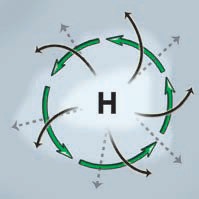
2. In an area of high pressure, the pressure-gradient force pushes air laterally out in all directions. As with a low pressure, this outward flow of air is influenced by the Coriolis effect and by friction near Earth’s surface. As air flows outward from the high, it is replaced by air flowing down from higher in the atmosphere.
Northern Hemisphere
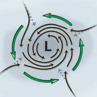
3. Earth does rotate, so the Coriolis effect, represented in this figure by green arrows, deflects the inward-flowing air associated with a low-pressure area. This deflection causes an inwardspiraling rotation pattern called a cyclone. In the Northern Hemisphere, the Coriolis deflection is to the right of its intended path, causing a counterclockwise rotation of air around the lowpressure zone. This counterclockwise rotation is evident in Northern Hemisphere storms.
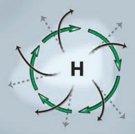
4. In a Northern Hemisphere highpressure area, the Coriolis effect deflects winds to the right, but friction again slows the winds. This results in an outwardspiraling rotation pattern called an anticyclone. In the Northern Hemisphere, circulation around an anticyclone is clockwise around the high-pressure zone.
Southern Hemisphere
5. For a low-pressure area in the Southern Hemisphere, the air flowing inward toward a low is deflected to the left by the Coriolis effect. This causes air within a cyclone in the Southern Hemisphere to rotate clockwise, opposite to what is observed in the Northern Hemisphere. In either hemisphere, friction causes wind patterns within cyclones to be intermediate between straight-inward winds and circular gradient winds.
6. For a high in the Southern Hemisphere, the air flowing outward from the high is deflected to the left by the Coriolis effect. This causes the air within an anticyclone in the Southern Hemisphere to rotate counterclockwise, opposite to the pattern in the Northern Hemisphere. Therefore, cyclones and anticyclones can rotate either clockwise or counterclockwise, depending on hemisphere.
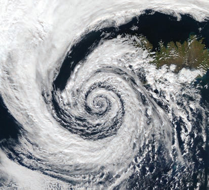
7. This satellite image shows a cyclone near Iceland (Northern Hemisphere). It is characterized by a circular rotation of strong winds around the innermost part of the storm. It displays a distinctive inward-spiraling flow of the clouds and air around an area of low air pressure. Within a cyclone, air moves rapidly down the pressure gradient toward the very low pressure at the center of the storm. In the Northern Hemisphere, the air is deflected to the right of its intended path, resulting in an overall counterclockwise rotation of the storm. The distinctive spiral pattern results from a combination of the pressure-gradient force (which started the air moving), the Coriolis effect, and friction with Earth’s surface. A hurricane, which is a huge tropical cyclone, shows a similar pattern of rotation around the center of the storm — the eye of the hurricane.
What Factors Influence Global Wind Patterns?
Insolation warms equatorial regions more than the poles, setting up pressure differences that drive large-scale atmospheric motion. Once set in motion, the moving air is acted upon by the Coriolis effect and by friction with Earth’s surface. These factors combine to produce curving patterns of circulating wind that dominate wind directions, climate, and weather.
Rotation and Deflection
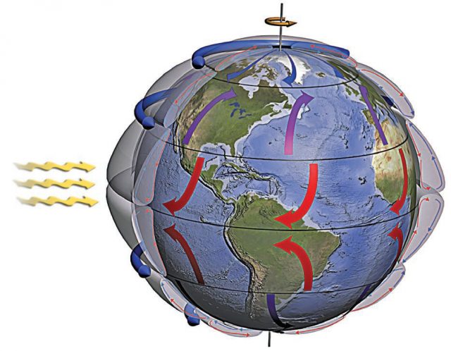
1. Earth is a spinning globe, with the equatorial region having a higher velocity than polar regions. As a result, air moving north or south is deflected from its intended path by the Coriolis effect.
2. Equatorial regions receive more sunlight than do areas closer to the poles and so preferentially heat up. As Earth rotates, the Sun’s heat forms a band of warm air that encircles the globe and is re-energized by sunlight each day.
3. Warmed equatorial air rises and flows north and south, away from the equator. Air at the surface flows toward the equator to replace the air that rises. The Coriolis effect deflects this equatorial-flowing surface wind toward the west (to the left in the Southern Hemisphere and to the right in the Northern Hemisphere).
4. These flows of air combine into huge, tube-shaped cells of circulating winds, called circulation cells. Very fast flows of air along the boundaries of some circulation cells are jet streams.
Prevailing Winds
5. Wind direction is referenced by the direction from which it is coming. A wind coming from the west is said to be a “west wind.” A wind that generally blows from the west is a westerly.
6. Polar regions receive the least solar heating and are very cold. Surface winds move away from the poles, carrying cold air with them. Polar easterlies blow away from the North Pole and have a large apparent deflection toward the west because the Coriolis effect is strong at high latitudes.
7. Westerlies dominate a central belt across the U.S. and Europe, so weather in these areas generally moves from west to east.
8. Northeast trade winds blow from the northeast and were named by sailors, who took advantage of the winds to sail from the so-called Old World to the New World.
9. Southeast trade winds blow from the southeast toward the equator. Near the equator, they meet the northeast trade winds in a stormy boundary called the Intertropical Convergence Zone (ITCZ).
10. Westerlies also occur in the Southern Hemisphere and are locally very strong because this belt is mostly over the oceans and has few continents to generate additional friction to disrupt the winds.
11. Polar easterlies flow away from the South Pole and deflect toward the west but are mostly on the back side of the globe in this view. The Coriolis effect causes this large apparent deflection due to the very high latitudes.
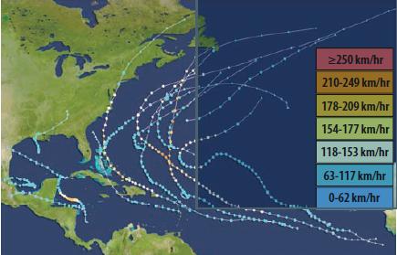
12. The origins and paths of hurricanes in the North Atlantic and Caribbean basins in 2011 are shown here. Note that few storms originate in the far southern part of this map, partly because the Coriolis effect is so small at these latitudes that it fails to impart the necessary rotation to the storms. Once formed, the paths of hurricanes are steered by the global wind patterns, which generally move Atlantic hurricanes west (guided by the trade winds) and then north and east once they enter the latitudes of the westerlies.